

Mori Atlas logo
Nature reserveTorsa Strict Nature Reserve

Mapping the protected boundaries and natural terrain of this key nature reserve in the Eastern Himalayas.

Torsa Strict Nature Reserve: Protected Landscape Identity and Geographic Context in Bhutan

(Jigme Khesar Strict Nature Reserve)

Explore Torsa Strict Nature Reserve, a significant protected area located within the mountainous geography of Bhutan. This atlas-focused page details the park's identity as a nature reserve, providing crucial context for understanding its mapped landscape, protected boundaries, and regional significance within the Eastern Himalayas. Discover the unique geographic character of this protected land and its place in Bhutan's conservation landscape.

Strict Nature ReserveHimalayan ForestsAlpine EcosystemsSnow Leopard HabitatBhutan Protected AreasTemperate Forests

Torsa Strict Nature Reserve

Nature reserve

Park overview

Structured park overview, official facts, and landscape profile for Torsa Strict Nature Reserve

Torsa Strict Nature Reserve park facts, protected area profile, and essential visitor context

Review the core facts for Torsa Strict Nature Reserve, including designation, size, terrain, visitor scale, habitats, and operating context in one park-focused overview.

About Torsa Strict Nature Reserve

Torsa Strict Nature Reserve represents one of Bhutan's most significant conservation achievements, established as part of the kingdom's pioneering approach to maintaining at least 60% of its territory under forest cover in perpetuity. The reserve's strategic location along Bhutan's northwestern border places it at a critical junction between Himalayan temperate ecosystems and the broader East Himalayan biodiversity hotspot. Its elevation gradient from 1,400 to 4,800 meters encompasses a complete sequence of Himalayan forest types, from broadleaf monsoon forests through coniferous forests to alpine grasslands and rock outcrops. The reserve's connection to Jigme Dorji National Park via a designated biological corridor creates a larger conservation landscape that facilitates wildlife movement across elevational zones and seasonal habitats. The absence of permanent human settlement within the reserve boundaries distinguishes it from many Himalayan protected areas and contributes to its ecological integrity.

Quick facts and research context for Torsa Strict Nature Reserve

Torsa Strict Nature Reserve protects Bhutan's westernmost temperate forests, ranging from broadleaf woodlands at 1,400 meters elevation through subalpine zones to alpine meadows at 4,800 meters. The reserve contains the small lakes of Sinchulungpa and is drained by the Torsa Chu river, which flows into the valley from Tibet's Chumbi Valley. Founded in 1993 by royal decree, the reserve is managed in coordination with the Bhutan Trust Fund for Environmental Conservation. Its strict protection status reflects both the ecological sensitivity of its alpine and forest habitats and the absence of human settlement within its boundaries.

Protection and recognition

Understanding terrestrial boundaries and global transboundary conservation frameworks.

Documented Protection Status and Transboundary Framework of Torsa Strict Nature Reserve

Environmental researchers can assess the terrestrial protection status and documented transboundary frameworks of Torsa Strict Nature Reserve. Verifying official designation histories and spatial records provides critical geographic context for evaluating contiguous cross-border habitats.

Protection details

Protection scope
Terrestrial
Transboundary protection
Yes
Park context

Deeper park guide and search-rich context for Torsa Strict Nature Reserve

Torsa Strict Nature Reserve history, landscape, wildlife, and travel context

Explore Torsa Strict Nature Reserve through its history, landscape character, ecosystems, wildlife, conservation priorities, cultural context, and seasonal travel timing in a structured park guide built for atlas discovery and search intent.

Why Torsa Strict Nature Reserve stands out

Torsa Strict Nature Reserve is distinguished by its position as Bhutan's westernmost temperate forest reserve and its remarkable altitudinal range spanning over 3,400 meters. The reserve protects significant populations of endangered species including the snow leopard, red panda, and rufous-necked hornbill. It contains the only endemic poppy species in Bhutan, the white poppy, which grows nowhere else in the country. The reserve's lack of resident human population makes it one of Bhutan's most ecologically intact protected areas, with forest and alpine ecosystems functioning largely without anthropogenic interference.

Torsa Strict Nature Reserve history and protected-area timeline

Torsa Strict Nature Reserve was established in 1993 through a decision of Bhutan's royal government, which at that time created a comprehensive national park and protected area system to safeguard the kingdom's extraordinary biodiversity. The establishment of Torsa and other reserves marked a transition from earlier conservation approaches toward a more systematic framework aligned with modern biodiversity conservation principles. The reserve was officially named Jigme Khesar Strict Nature Reserve in honor of the current Druk Gyalpo (king) of Bhutan, reflecting the tradition of commemorating royal figures through protected area designations. Since its founding, the reserve has been managed with strict protection protocols appropriate to its designation as a Strict Nature Reserve, which prohibits human habitation and limits visitor access to preserve ecological integrity.

Torsa Strict Nature Reserve landscape and geographic character

The terrain of Torsa Strict Nature Reserve exemplifies the dramatic Himalayan landscape, with steep river valleys carving through mountainous terrain that rises from the subtropical foothills into high alpine zones. The reserve encompasses the upper reaches of the Torsa Chu river system, which originates in Tibet's Chumbi Valley and flows through the reserve as it descends toward the Himalayan foothills. The small glacial lakes of Sinchulungpa add ecological diversity to the reserve's high-altitude landscape. Forest cover transitions with elevation from dense broadleaf forests in the lower valleys through mixed conifer forests to rhododendron-dominated shrublands and finally to alpine meadows and rocky terrain above the tree line. The western boundary follows natural topographic features along the border regions adjacent to Sikkim and Tibet.

Torsa Strict Nature Reserve ecosystems, habitats, and plant life

The ecological diversity of Torsa Strict Nature Reserve reflects its extensive altitudinal range and position at the western edge of Bhutan's forest zone. The reserve contains the westernmost extent of Bhutan's temperate forests, representing a biogeographic transition zone between Himalayan and eastern Himalayan forest communities. Broadleaf forests dominated by oak, maple, and birch give way at higher elevations to coniferous forests of pine, spruce, and fir before the forest line gives way to alpine meadows. These diverse habitats support remarkable plant diversity, including the white poppy, Bhutan's only endemic poppy species, which occurs nowhere else in the country. The ecological corridor connecting Torsa to Jigme Dorji National Park allows species to migrate seasonally across elevational gradients in response to changing snow conditions and resource availability.

Torsa Strict Nature Reserve wildlife and species highlights

Torsa Strict Nature Reserve supports a remarkable assemblage of endangered and charismatic species that depend on its intact forest and alpine habitats. The snow leopard, one of the world's most elusive large cats, inhabits the high alpine zones where its cryptic camouflage and remote habitat provide relative security. The red panda, a distinctive species of the Himalayan temperate forests, occupies the middle elevation zones where bamboo and dense vegetation provide cover and food. The rufous-necked hornbill, a striking bird species with an imposing casqued bill, inhabits the broadleaf forests of the lower elevations. The Tibetan snowcock, a gamebird adapted to high-altitude environments, is among the specialized species that have evolved to thrive in the reserve's alpine meadows and rock-strewn terrain.

Torsa Strict Nature Reserve conservation status and protection priorities

The conservation significance of Torsa Strict Nature Reserve derives from multiple factors: its role as a strict protected area with no human population, its position protecting Bhutan's westernmost temperate forests, and its function as part of a larger connected conservation landscape. The reserve's strict nature reserve designation reflects its ecological sensitivity and the need to minimize disturbance to allow natural processes to continue unimpeded. Its inclusion in the network of protected areas connected by biological corridors enables landscape-scale conservation that accommodates species requiring large home ranges and seasonal movement corridors. The protection of habitat for endangered species including snow leopard, red panda, and rufous-necked hornbill contributes to Bhutan's role as a critical stronghold for Himalayan biodiversity.

Torsa Strict Nature Reserve cultural meaning and human context

Torsa Strict Nature Reserve differs from many of Bhutan's protected areas in that it has no resident human population, making it one of the country's strictest wilderness reserves. The Haa District surrounding the reserve contains traditional Bhutanese communities, and the cultural landscape of the broader region includes Buddhist monasteries and traditional agricultural practices. However, the reserve itself functions as a wilderness area with minimal direct human influence. The Torsa Chu river carries cultural significance as a transboundary watercourse flowing from Tibet into Bhutan, and the valley has historically served as a route for traditional trade and pilgrimage between the two regions.

Top sights and standout views in Torsa Strict Nature Reserve

Torsa Strict Nature Reserve stands as one of Bhutan's premier wilderness areas, protecting an exceptional altitudinal gradient from subtropical forests to alpine peaks. The reserve's endangered wildlife includes snow leopard, red panda, and rufous-necked hornbill, making it significant for global biodiversity conservation. Its status as a population-free strict nature reserve ensures that ecosystems function naturally without human interference. The reserve forms part of a larger connected conservation landscape with Jigme Dorji National Park, enabling wildlife movement across the Himalayan altitudinal gradient. Bhutan's commitment to maintaining 60% forest cover is embodied in this reserve's pristine forests and alpine meadows.

Best time to visit Torsa Strict Nature Reserve

The optimal seasons for experiencing Torsa Strict Nature Reserve align with Bhutan's general tourism patterns, with spring and autumn offering the most stable weather conditions. The spring months of March through May bring blooming rhododendrons and mild temperatures at lower elevations, while autumn from September through November provides clear skies and excellent visibility for mountain views. Summer monsoon months bring heavy rainfall to the lower elevations and may affect access to higher terrain. Winter months bring cold temperatures and snowfall at higher elevations, transforming the landscape but potentially limiting accessibility. Visitors seeking wildlife viewing opportunities may find different seasons offer varying advantages depending on species behavior and visibility.

Monthly climate preview

Long-term representative measurements of temperature and precipitation for Torsa Strict Nature Reserve

Torsa Strict Nature Reserve Climate Normals and Annual Weather Patterns

Historical data records a measured annual rhythm of monthly temperature variations and precipitation shifts across the representative coordinate. Detailed twelve-month records provide complete context for long-term climate normals and seasonal patterns.
Annual mean6 °C
-2 °C13 °C
Jan-2°
Feb-1°
Mar
Apr
May
Jun12°
Jul13°
Aug12°
Sep11°
Oct
Nov
Dec
Warmest month
July

12.6 °C

Coolest month
January

-1.9 °C

Wettest month
July

7.5 mm/day

Driest month
December

0.1 mm/day

Park location guide

Geography guide, regional context, and park location map for Torsa Strict Nature Reserve

Torsa Strict Nature Reserve park geography, regions, and map view in Bhutan

Understand where Torsa Strict Nature Reserve sits in Bhutan through a broader geographic reading of the surrounding landscape, nearby location context, and its mapped position within the national park landscape.

How Torsa Strict Nature Reserve fits into Bhutan

Bhutan, officially the Kingdom of Bhutan, is a landlocked country in South Asia situated in the Eastern Himalayas. With a population of approximately 727,000 and an area of 38,394 km², it is a constitutional monarchy ruled by the Wangchuck dynasty. The country is known for its Gross National Happiness philosophy, pristine mountain landscapes, and commitment to preserving its Buddhist culture.

Wider geography shaping Torsa Strict Nature Reserve in Bhutan

Bhutan is located in the Eastern Himalayas in South Asia, bordered by China to the north and northwest and India to the south and southeast. The country's terrain is predominantly mountainous with steep valleys, ranging from elevations around 100 meters in the southern foothills to peaks exceeding 7,000 meters in the northern highlands. The major river systems flow southward from the Himalayas into India's Brahmaputra basin.

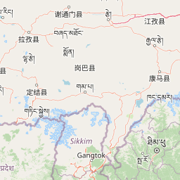
Map view of Torsa Strict Nature Reserve

Use this park location map to pinpoint Torsa Strict Nature Reserve in Bhutan, understand its exact geographic position, and read its mapped placement within the surrounding landscape more clearly.

Pigeon | © OpenStreetMap contributors
Park atlas

Explore adjacent Himalayan protected landscapes and compare nearby conservation zones, tracing Bhutan's unique park geography.

Discover Related Protected Areas and National Parks Near Torsa Strict Nature Reserve

Continue exploring protected areas surrounding Torsa Strict Nature Reserve, comparing its unique Himalayan forest and alpine ecosystems with other significant conservation landscapes across Bhutan and the wider region. Examining nearby parks allows for deeper understanding of interconnected protected area geography, revealing how these reserves form vital corridors in the eastern Himalayas.
National parkKalimpong district
About 34 km away#1 closest

Southwest

Neora Valley National Park: India's Protected Landscape in Kalimpong District

Explore mapped boundaries and regional geography.

Neora Valley National Park is a significant protected area designated as a national park in India, located within the Kalimpong district. This dedicated page provides detailed geographic information, focusing on its mapped boundaries and its role as a natural landscape within the region. Understand the specific protected-area context of Neora Valley National Park for atlas-based discovery.

Area
88 km²
Established
1986
IUCN
II
Relief
Mountain
National parkBhutan
About 36 km away#2 closest

Northeast

Jigme Dorji National Park: Bhutan's Vast Protected Landscape and Himalayan Geography

Explore mapped boundaries and diverse ecosystems within this national park.

Jigme Dorji National Park, located in the heart of Bhutan, is a testament to the country's commitment to conservation, covering over 4,300 square kilometers of pristine Himalayan terrain. This national park encompasses diverse ecosystems, from lush subtropical forests in its lower reaches to barren alpine meadows and permanent snowfields at its highest elevations. The park's extensive mapped boundaries showcase a landscape vital for unique wildlife and sacred cultural sites, offering a comprehensive view for atlas-based geographic discovery.

Area
4,316 km²
Established
1974
IUCN
II
Relief
Mountain
National parkSikkim
About 52 km away#3 closest

Northwest

Khangchendzonga National Park: National Park in Sikkim with Mapped Boundaries

Explore protected landscapes and regional geography.

Understand Khangchendzonga National Park as a key protected area within Sikkim, India. This entry provides focused atlas information on the park's geographic features, mapped boundaries, and its role as a national park, offering essential context for regional landscape discovery and exploration.

Area
1,784 km²
Established
1977
IUCN
II
Relief
Mountain
Wildlife reserveBhutan
About 57 km away#4 closest

East

Motithang Takin Preserve: Bhutan Wildlife Reserve with Unique Protected Landscape Context

Explore the mapped geography and national animal sanctuary.

The Motithang Takin Preserve offers a unique glimpse into Bhutan's dedication to its national animal, the takin. This wildlife reserve, located near the capital city, provides a defined protected area where the distinctive goat-antelope thrives. By examining the preserve's mapped boundaries and its forested terrain, users gain insight into Bhutan's approach to conservation and the cultural significance of this iconic species within the Himalayan landscape.

Area
0.034 km²
IUCN
IV
Relief
Upland
Climate
Temperate
National parkAlipurduar district
About 74 km away#5 closest

South

Jaldapara National Park: India's Premier Grassland and Rhino Conservation Landscape

Explore mapped boundaries and savanna terrain in Alipurduar district.

Jaldapara National Park is a protected national park in India's Alipurduar district, celebrated for its expansive rolling grasslands and significant population of Indian one-horned rhinoceros. This protected area showcases a distinctive savanna landscape, an unusual feature among Indian national parks, interspersed with riverine forests. Its elevation of 61 meters above sea level positions it at the edge of the Eastern Himalayas, offering a unique geographic setting for understanding regional biodiversity and conservation efforts.

Area
216.51 km²
Established
1941
IUCN
II
Relief
Lowland
National parkJalpaiguri district
About 74 km away#6 closest

South

Gorumara National Park: India National Park Atlas and Protected Landscape Geography

Discover the mapped boundaries and regional terrain.

Gorumara National Park stands as a vital protected natural area within India's Jalpaiguri district. This entry provides detailed atlas-focused information, detailing the park's geographic identity and its position within the regional landscape context. Understand the mapped protected boundaries and explore the unique terrain that characterizes Gorumara National Park as a key national park entity. It serves as a foundational point for geographic discovery within India's network of protected lands.

Area
79.99 km²
Established
1992
IUCN
II
Relief
Mixed relief
National parkAlipurduar district
About 91 km away#7 closest

Southeast

Buxa Tiger Reserve National Park: Protected Landscape Exploration in Alipurduar District

Mapped boundaries and diverse ecosystems within India's easternmost tiger reserve.

Buxa Tiger Reserve, a designated national park in India's Alipurduar district, offers a profound look into a protected landscape at the crossroads of major biogeographic zones. Its terrain ascends from the Gangetic Plains to the Himalayan foothills, showcasing a rich tapestry of forest types and supporting significant faunal diversity. This reserve functions as a crucial international elephant corridor, facilitating wildlife movement between India and Bhutan, and stands as a testament to the importance of mapped protected areas in transboundary conservation efforts.

Area
760 km²
Established
1983
IUCN
II
Relief
Mixed relief
National parkDarjeeling District
About 101 km away#8 closest

West

Singalila National Park: A High-Altitude Protected Landscape on the Eastern Himalayan Ridge

Explore mapped terrain and alpine park geography in Darjeeling District.

Singalila National Park represents a crucial protected natural landscape within the Eastern Himalayas, located in India's Darjeeling District. Defined by its dramatic ridgeline that ascends to over 4,000 meters, the park offers a unique alpine environment with stunning panoramic views. Its designation as a national park highlights its importance for conservation and its role in the regional geographic atlas. Discover the mapped boundaries and ecological context of this remarkable mountain wilderness, from its dense forests to its open alpine meadows.

Area
78.6 km²
Established
1986
IUCN
II
Relief
Mountain

Common questions about visiting, size, designation, and location context for Torsa Strict Nature Reserve

Torsa Strict Nature Reserve FAQs for park facts, access, geography, and protected area context

Find quick answers about Torsa Strict Nature Reserve, including protected-area facts, park geography, trail and visitor context, and how the park fits into its surrounding country and regional landscape.
MoriAtlas Explorer

Continue Your Protected Areas Search Across the Global Atlas

Deepen your exploration by continuing the structured search for national parks and protected areas worldwide. Utilize the comprehensive filtering capabilities to compare different conservation landscapes and refine your understanding of global park geography. Discover more about the distribution and characteristics of protected natural areas.

Global natural geography