

Mori Atlas logo
National parkTully Gorge National Park

Discover the mapped boundaries and natural terrain of this national park in Queensland.

Tully Gorge National Park: Queensland's Protected Landscape and Geographic Context

Tully Gorge National Park represents a significant protected landscape within Queensland, Australia, offering a unique lens for geographic discovery. As a designated national park, its mapped boundaries define a critical area for understanding regional natural terrain and landscape context. This page serves as an entry point to explore the park's geographic identity and its place within the broader Queensland atlas, providing structured information for atlas-based analysis and exploration of protected lands.

National ParkWaterfallsGorgeRainforestWet TropicsQueensland

Tully Gorge National Park

National park

Park overview

Structured park overview, official facts, and landscape profile for Tully Gorge National Park

Tully Gorge National Park park facts, protected area profile, and essential visitor context

Review the core facts for Tully Gorge National Park, including designation, size, terrain, visitor scale, habitats, and operating context in one park-focused overview.

About Tully Gorge National Park

Tully Gorge National Park occupies a significant position in Far North Queensland's protected area network, preserving a rugged landscape of deep gorges, waterfalls, and dense tropical rainforest. The park is centred around the Tully River, which has carved a spectacular gorge over millions of years, creating the dramatic terrain that defines the area. Tully Falls represents the park's most iconic feature, a powerful waterfall that descends 300 metres down a steep rock face during the wet season months. The surrounding landscape features towering cliff walls covered in verdant rainforest, creating a striking contrast between the lush vegetation and the exposed rock. The park lies within the Wet Tropics of Queensland bioregion, an area recognized internationally for its extraordinary biological diversity and ecological significance. Visitors can access the park via Tully Falls Road, which branches from Mount Garnet Road near Ravenshoe, leading to viewing platforms and walking tracks that showcase the gorge and waterfall.

Quick facts and research context for Tully Gorge National Park

Tully Gorge National Park covers 543 square kilometres of Far North Queensland terrain and was established in 1923, making it one of Queensland's older protected areas. The park is located near the town of Ravenshoe and features the spectacular Tully Falls, which only flow during the wet season but remain a striking geological feature year-round. The park is part of the Wooroonooran Important Bird Area, identified by BirdLife International for its populations of bird species endemic to Queensland's Wet Tropics. The landscape is characterized by deep gorges carved by the Tully River, dense rainforest covering steep valley walls, and mountainous terrain rising from the river basin.

Protection and recognition

Documenting the terrestrial boundaries, management scope, and official designation status.

Tully Gorge National Park Protection Status and Terrestrial Designation

Verifying the terrestrial protection status of Tully Gorge National Park provides essential insight into its defined geographic limits and official designation framework. Documented classification data and official registration records assist researchers in tracking how the park fits into broader global conservation frameworks.

Protection details

Protection scope
Terrestrial
Transboundary protection
No
Park context

Deeper park guide and search-rich context for Tully Gorge National Park

Tully Gorge National Park history, landscape, wildlife, and travel context

Explore Tully Gorge National Park through its history, landscape character, ecosystems, wildlife, conservation priorities, cultural context, and seasonal travel timing in a structured park guide built for atlas discovery and search intent.

Why Tully Gorge National Park stands out

Tully Gorge National Park is best known for its dramatic waterfall and gorge landscape, particularly Tully Falls, which drops 300 metres through rainforest-covered rock faces into the Tully River gorge. The park is also renowned as part of the Wet Tropics of Queensland, one of Earth's most biodiversity-rich regions, and is recognized as an Important Bird Area supporting endemic species. The contrast between the dry, sheer rock walls and the lush green rainforest creates a distinctive visual character that draws visitors seeking to experience one of Queensland's most impressive natural landmarks.
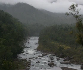
A river with rocks flows through a forested gorge with mountains in the background under overcast skies
River flowing through a misty gorge in Tully Gorge National Park

Tully Gorge National Park history and protected-area timeline

Tully Gorge National Park was established in 1923, representing one of Queensland's earliest efforts to protect significant natural landscapes. The creation of the park reflected growing recognition of the scenic and ecological value of the Wet Tropics region. Over the decades, the park has been managed by the Queensland Parks and Wildlife Service, which continues to oversee protection of its natural values while providing visitor access to appropriate areas. The park's long-standing protected status has helped preserve its dramatic landscape and biodiversity through periods of regional development and changing land use patterns.

Tully Gorge National Park landscape and geographic character

The landscape of Tully Gorge National Park is defined by the deep incision of the Tully River through the mountainous terrain of Far North Queensland. The river has carved a spectacular gorge with steep walls rising from the watercourse, creating a landscape of considerable vertical relief. Tully Falls marks a dramatic point where the river plunges over a 300-metre rock face, creating one of the most impressive waterfalls in Queensland. The gorge walls and surrounding terrain are heavily forested with tropical rainforest, though the falls themselves are characterized by sheer rock faces that stand in contrast to the green vegetation surrounding them. The park encompasses the broader catchment area and associated landscape features that contribute to the gorges dramatic character.

Tully Gorge National Park ecosystems, habitats, and plant life

Tully Gorge National Park sits within the Wet Tropics of Queensland, a globally significant bioregion known for its exceptional plant and animal diversity. The parks diverse habitats range from riparian zones along the Tully River to steep rainforest-covered slopes and rocky cliff faces. The tropical rainforest environment supports an array of species adapted to the warm, wet conditions of northern Queensland. The park forms part of the Wooroonooran Important Bird Area, recognized by BirdLife International for its significance to endemic bird species. The combination of intact rainforest, clean watercourses, and protected status provides important habitat connectivity within the broader Wet Tropics landscape.

Tully Gorge National Park wildlife and species highlights

The wildlife of Tully Gorge National Park is particularly significant due to the parks location within the Wet Tropics of Queensland, a region renowned for its high levels of endemism. As part of the Wooroonooran Important Bird Area, the park supports populations of bird species found nowhere else on Earth, including several species restricted to Queenslands wet tropics. The diverse habitats from riverine environments to rainforest canopy support varied wildlife communities. While specific species details are limited in available sources, the parks Important Bird Area designation indicates significant avifauna populations, particularly species associated with intact tropical rainforest.

Tully Gorge National Park conservation status and protection priorities

Tully Gorge National Park contributes to the conservation of one of Earths most biologically significant regions. The Wet Tropics of Queensland is recognized internationally as a biodiversity hotspot, and protected areas like Tully Gorge form essential nodes within the regional conservation network. The parks designation as part of the Wooroonooran Important Bird Area demonstrates its specific importance for bird conservation, with BirdLife International identifying it as supporting populations of endemic species. The long-standing protected status since 1923 has helped maintain the landscapes integrity, preserving both its scenic values and ecological functions within the broader regional ecosystem.

Tully Gorge National Park cultural meaning and human context

The Tully Gorge area lies within the traditional country of the Jirrbal people, an Indigenous Australian group with historical connections to the lands and waterways of the Wet Tropics region. The Tully River and gorge landscape would have held cultural significance for local Aboriginal communities, as rivers and prominent landscape features often feature in Indigenous heritage and traditional knowledge. Ravenshoe, the nearby town that provides access to the park, was established as a timber-getting settlement and later became a service centre for the surrounding agricultural and mining areas.

Top sights and standout views in Tully Gorge National Park

The central highlight of Tully Gorge National Park is the spectacular Tully Falls, a 300-metre waterfall that thunders over sheer rock walls during the wet season. The Tully Gorge Lookout provides visitors with views of the waterfall and the deep gorge below. An 800-metre walking track leads walkers to the Tully River above the falls, allowing close appreciation of the rivers power and the surrounding rainforest. The parks location within the Wet Tropics of Queensland provides a backdrop of pristine tropical rainforest that enhances the dramatic gorge landscape. The Important Bird Area designation adds ecological significance to the visitor experience.

Best time to visit Tully Gorge National Park

The best time to visit Tully Gorge National Park depends on what visitors wish to experience. The wet season, typically from November to April, brings the flowing waterfall as the Tully River swells with rainfall, creating the spectacular cascade that defines the parks most famous view. However, the wet season also means the waterfall is at its most impressive, and the surrounding rainforest is at its most verdant. The dry season may offer easier access and clearer conditions, though visitors should note that Tully Falls may not flow during this period. The dramatic rock walls and gorge remain impressive year-round, and the rainforest maintains its appeal in all seasons.

Monthly climate preview

Comparing long-term temperature ranges and daily precipitation averages in Queensland

Tully Gorge National Park Average Temperatures and Weather by Month

Long-term averages at this Queensland reserve show warm peak mean temperatures reaching 24.7 degrees Celsius alongside significant daily rainfall earlier in the year. Accessing the complete climate profile reveals detailed monthly fluctuations in minimum and maximum temperatures across the entire seasonal cycle.
Annual mean21 °C
16 °C25 °C
Jan24°
Feb24°
Mar23°
Apr21°
May19°
Jun17°
Jul16°
Aug17°
Sep20°
Oct22°
Nov24°
Dec25°
Warmest month
December

24.7 °C

Coolest month
July

16.3 °C

Wettest month
February

13.4 mm/day

Driest month
September

1.1 mm/day

Park location guide

Geography guide, regional context, and park location map for Tully Gorge National Park

Tully Gorge National Park park geography, regions, and map view in Australia

Understand where Tully Gorge National Park sits in Australia through a broader geographic reading of the surrounding landscape, nearby location context, and its mapped position within the national park landscape.

How Tully Gorge National Park fits into Australia

Australia is a constitutional monarchy and federal parliamentary democracy comprising six states and ten territories. With a population of nearly 28 million, it is one of the world's most urbanised countries, with most people concentrated on the eastern seaboard. The country has a high Human Development Index and is known for its cultural diversity, ancient Aboriginal heritage, and unique wildlife.

Wider geography shaping Tully Gorge National Park in Australia

Australia occupies the entire Australian continent, the island of Tasmania, and numerous smaller islands. It is the world's flattest and driest inhabited continent, featuring vast deserts in the interior (the Outback), tropical rainforests along the eastern coast, and a coastline bordering the Indian and Pacific Oceans.

Map view of Tully Gorge National Park

Use this park location map to pinpoint Tully Gorge National Park in Australia, understand its exact geographic position, and read its mapped placement within the surrounding landscape more clearly.

Pigeon | © OpenStreetMap contributors

Location context for Tully Gorge National Park

Queensland

Explore the visual character of Tully Gorge National Park, tracing its unique gorge, waterfalls, and tropical rainforest environment.

Tully Gorge National Park Photos: Discover the Stunning Landscape and Wilderness Scenery

Browse a curated collection of imagery showcasing Tully Gorge National Park's spectacular waterfall, deep river gorge, and lush tropical rainforest. These photographs offer a vital visual reference for understanding the park's dramatic terrain, unique habitats, and the distinctive protected-area environment of Far North Queensland.

A river with rocks flows through a forested gorge with mountains in the background under overcast skies

Park atlas

Trace the geographic spread of protected landscapes across Far North Queensland and the Wet Tropics region.

Explore Other National Parks and Protected Areas Near Tully Gorge National Park

After exploring Tully Gorge National Park, browse other national parks and protected areas mapped across Far North Queensland, including more sites within the remarkable Wet Tropics of Queensland World Heritage Area. Compare the distinct features of adjacent rainforests, gorges, and waterfall landscapes, gaining deeper insight into regional conservation efforts and diverse protected-area geography.
National parkTablelands Region
About 6.7 km away#1 closest

Southwest

Koombooloomba National Park: Endangered Wet Sclerophyll Forest Atlas & Geographic Discovery

Mapping the protected landscape of this Queensland national park.

Koombooloomba National Park serves as a vital sanctuary for one of eastern Australia's most endangered forest types, wet sclerophyll forest. Its inclusion within the Wet Tropics World Heritage Area highlights its global ecological importance, preserving ancient rainforest ecosystems and unique regional biodiversity. This detailed entry offers an atlas-driven perspective on the park's protected boundaries and its distinct landscape, situated within the Tablelands Region's geography.

Area
292.58 km²
IUCN
II
Climate
Tropical
Scope
Terrestrial
National parkQueensland
About 6.8 km away#2 closest

North

Wooroonooran National Park: Queensland's Protected Landscape Atlas Explorer

Mapping the geography and protected area context of Queensland.

Delve into the specifics of Wooroonooran National Park, a nationally designated protected area situated in Queensland. This section offers detailed geographic insights, focusing on its mapped boundaries and the surrounding natural landscape. Understand how Wooroonooran National Park fits within the broader regional geography of northeastern Australia, supporting structured atlas exploration of protected lands.

Area
798 km²
Established
1991
IUCN
II
Relief
Mountain
National parkQueensland
About 11 km away#3 closest

Northeast

Japoon National Park: Protected Landscape Exploration and Geographic Mapping in Queensland

Discover mapped boundaries and regional context.

Uncover the protected landscape of Japoon National Park, a designated national park situated in Queensland, Australia. This entry facilitates a deeper understanding of its geographic position and mapped boundaries, essential for atlas-based exploration of Australia's protected areas. Engage with the park's inherent geographic identity and its role within the wider regional context of northeastern Australia, focusing on structured discovery and landscape context.

Area
450 km²
Established
1992
IUCN
II
Climate
Tropical
National parkAustralia
About 32 km away#4 closest

Northwest

Malaan National Park: Protected Landscape Identity and Geographic Setting within Australia

Explore Malaan National Park's mapped boundaries and regional geography.

Malaan National Park represents a key protected area within Australia's geographic framework. This detailed entry offers insights into the park's unique landscape characteristics and its mapped extent, contributing to a structured atlas of Australia's natural protected lands. Understand the specific geography and protected land context that defines Malaan National Park, essential for detailed map-based exploration and regional geographic study.

IUCN
II
National parkQueensland
About 32 km away#5 closest

Northwest

Maalan National Park: A Geological Landmark and Protected Nature Reserve in Queensland

High elevation volcanic terrain and Wet Tropics biodiversity

Maalan National Park stands as a key protected area within the Atherton Tableland, characterized by its inclusion of Mount Fisher and unique volcanic landscape features. The park provides critical refuge for endangered species and supports over 500 native plant species, contributing to the broader ecological health of the Queensland wilderness network.

Area
24.73 km²
Established
2005
IUCN
II
Relief
Mixed relief
National parkAustralia
About 33 km away#6 closest

Southeast

Mount Mackay National Park: Australia's Protected Landscape and Geographic Identity

Explore the mapped boundaries and regional atlas context.

Mount Mackay National Park represents a key protected area within Australia, contributing to the nation's geographic atlas. This entry facilitates a deep understanding of its specific landscape character and mapped geographic position. Discover how this national park fits into the broader context of protected lands and regional terrain, providing rich data for atlas exploration.

Access
Access unknown
Water
No major water
Season
Year-round
National parkQueensland
About 33 km away#7 closest

Northwest

Millstream Falls National Park: Australia's Widest Single-Drop Waterfall and Queensland Geography

Explore the mapped boundaries and unique landscape of this significant national park.

Millstream Falls National Park, a protected area in Far North Queensland, Australia, stands out for its impressive Big Millstream Falls, recognized as the widest single-drop waterfall in the country. This national park provides a concentrated study of volcanic geology and tropical landscape, with the waterfall cascading over a basalt cliff amid lush vegetation. As a key component of Queensland's protected lands, its mapped boundaries and regional geographic context are essential for understanding this unique natural feature. The park's compact size and dramatic scenery offer a distinct atlas point for exploring Australia's diverse natural heritage.

Area
3.72 km²
IUCN
II
Scope
Terrestrial
Water
Minor water
National parkQueensland
About 33 km away#8 closest

Northeast

Palmerston Rocks National Park: National Park Protected Landscape and Regional Geography

Explore mapped boundaries within Queensland's diverse natural terrain.

Palmerston Rocks National Park serves as a vital component of Queensland's protected natural areas, offering a unique lens through which to understand Australia's broader geographic context. This national park designation highlights specific landscape features and mapped boundaries, providing essential data for atlas and geography enthusiasts seeking to explore protected lands. Its location within northeastern Australia anchors it within a region known for its wide-ranging natural environments.

Area
0.1 km²
IUCN
II
Scope
Terrestrial
Water
No major water

Common questions about visiting, size, designation, and location context for Tully Gorge National Park

Tully Gorge National Park FAQs for park facts, access, geography, and protected area context

Find quick answers about Tully Gorge National Park, including protected-area facts, park geography, trail and visitor context, and how the park fits into its surrounding country and regional landscape.
MoriAtlas Explorer

Continue Your Protected Areas Search Across the Global Atlas

Deepen your exploration by continuing the structured search for national parks and protected areas worldwide. Utilize the comprehensive filtering capabilities to compare different conservation landscapes and refine your understanding of global park geography. Discover more about the distribution and characteristics of protected natural areas.

Global natural geography