
Mori Atlas logo
Protected landscapeUm die Großwiese

A detailed geographic examination of meadow mosaics, orchard strips, and riparian forest corridors.

Um die Großwiese Protected Landscape: Mapping the Cultural Terrain of Northern Kraichgau

(Landschaftsschutzgebiet „Um die Großwiese“)

The Um die Großwiese protected landscape represents a coherent cultural geography within the northern Kraichgau region of Baden-Württemberg. This area features a mosaic of species-rich grassland, traditional orchard meadows, and oak-hornbeam forest sections. Through mapped boundaries and topographic analysis, discover the intersection of riparian woodland and vineyard slopes that define this designated recreation landscape.

protected landscapeLandschaftsschutzgebietKraichgaumeadowstraditional orchardsStreuobst
Stylized digital illustration showing a valley with mountains, a small waterfall, and coniferous trees in a pastel color palette.

Um die Großwiese

Protected landscape

Park overview

Structured park overview, official facts, and landscape profile for Um die Großwiese

Um die Großwiese park facts, protected area profile, and essential visitor context

Review the core facts for Um die Großwiese, including designation, size, terrain, visitor scale, habitats, and operating context in one park-focused overview.

About Um die Großwiese

Um die Großwiese is one of many landscape protection areas in the Landkreis Karlsruhe, but it stands out for capturing a complete slice of the Kraichgau's traditional land use within a single designated perimeter. Located east of Langenbrücken, a district of Bad Schönborn, the protected landscape stretches across the rolling terrain of the northern Kraichgau's foothills, where agricultural land, orchards, vineyards, and forest have long coexisted.

The area is bounded by recognizable reference points: the Bundesstraße 292 in the north, the Gründelgraben stream and the municipal boundary with Östringen in the east, and the boundary with Ubstadt-Weiher in the south. Within these limits, the protected landscape combines open, species-rich grassland, extensive traditional orchards, field hedgerows, small brooks lined by gallery woodland, vineyards, and a closed forest block on the eastern side. This mixture of habitats reflects centuries of small-scale land management in the Kraichgau, where vineyards, orchards, meadows, and woodland together form the regional cultural landscape.

Administered by the Landratsamt Karlsruhe under ordinance of 19 October 1990, the protection area is registered in the official Baden-Württemberg Schutzgebietsverzeichnis under the identifier 2.15.052 and is also referenced in the World Database on Protected Areas under WDPA ID 325275. It overlaps in part with the European FFH site Nördlicher Kraichgau, extending its conservation relevance beyond local landscape protection into the broader Natura 2000 ecological network. The natural monument Magerwiese Pfarrwald, a low-nutrient meadow feature, also lies within its scope, adding further ecological interest.

Beyond its ecological and landscape value, Um die Großwiese is explicitly designated to serve as a recreation area for nearby residents and spa guests, given Bad Schönborn's status as a health resort community. The combination of scenic diversity, traditional agricultural land use, and proximity to the town gives the protected landscape a strong local identity, both as a piece of working cultural countryside and as a nearby nature experience for the community.

Quick facts and research context for Um die Großwiese

Um die Großwiese is a protected landscape (Landschaftsschutzgebiet) located in the municipality of Bad Schönborn in Landkreis Karlsruhe, Baden-Württemberg, Germany. It was designated by ordinance of the Landratsamt Karlsruhe on 19 October 1990 and covers around 2.5 square kilometers in the northern Kraichgau.

The area lies in the foothill belt of the Kraichgau, east of the Langenbrücken district, and is bounded by the B 292 federal road to the north and the Gründelgraben stream and municipal boundaries to the east and south. Its core landscape ingredients include species-rich meadows, traditional orchards, field hedgerows, small streams with riparian woodland, vineyards, and a contiguous oak-hornbeam forest. The site partly overlaps with the FFH area Nördlicher Kraichgau, and the natural monument Magerwiese Pfarrwald lies within its boundaries.

Protection and recognition

Terrestrial conservation framework and official protected area records

Um die Großwiese Protection Status and Documented Conservation Scope

Um die Großwiese maintains a documented terrestrial protection status within official conservation databases. Recorded designation frameworks establish the foundational management scope and baseline geographic boundaries for the protected area.

Protection details

Protection scope
Terrestrial
Transboundary protection
No
WDPA ID
325275
Park context

Deeper park guide and search-rich context for Um die Großwiese

Um die Großwiese history, landscape, wildlife, and travel context

Explore Um die Großwiese through its history, landscape character, ecosystems, wildlife, conservation priorities, cultural context, and seasonal travel timing in a structured park guide built for atlas discovery and search intent.

Why Um die Großwiese stands out

Um die Großwiese is especially known for being a representative Kraichgau cultural landscape, where species-rich meadows, traditional Streuobst orchards, hedgerows, vineyards, and oak-hornbeam forest still coexist as a single protected mosaic. The area is recognized for preserving a large, contiguous tract of meadowland along with associated wetlands, riparian vegetation, and forest, rather than a single dominant feature. Its protection target explicitly bundles several landscape elements, including Feuchtwiesen (moist meadows), Streuobst (traditional orchards), Bachgehölze (streamside woodland), a sessile oak and hornbeam forest preserved as recreation forest, and a vineyard area within the Vorbergzone. The combination of grassland promotion, traditional orchard preservation, and forest retention gives the protected area a layered identity that distinguishes it from neighboring, more narrowly focused reserves in the Landkreis Karlsruhe.
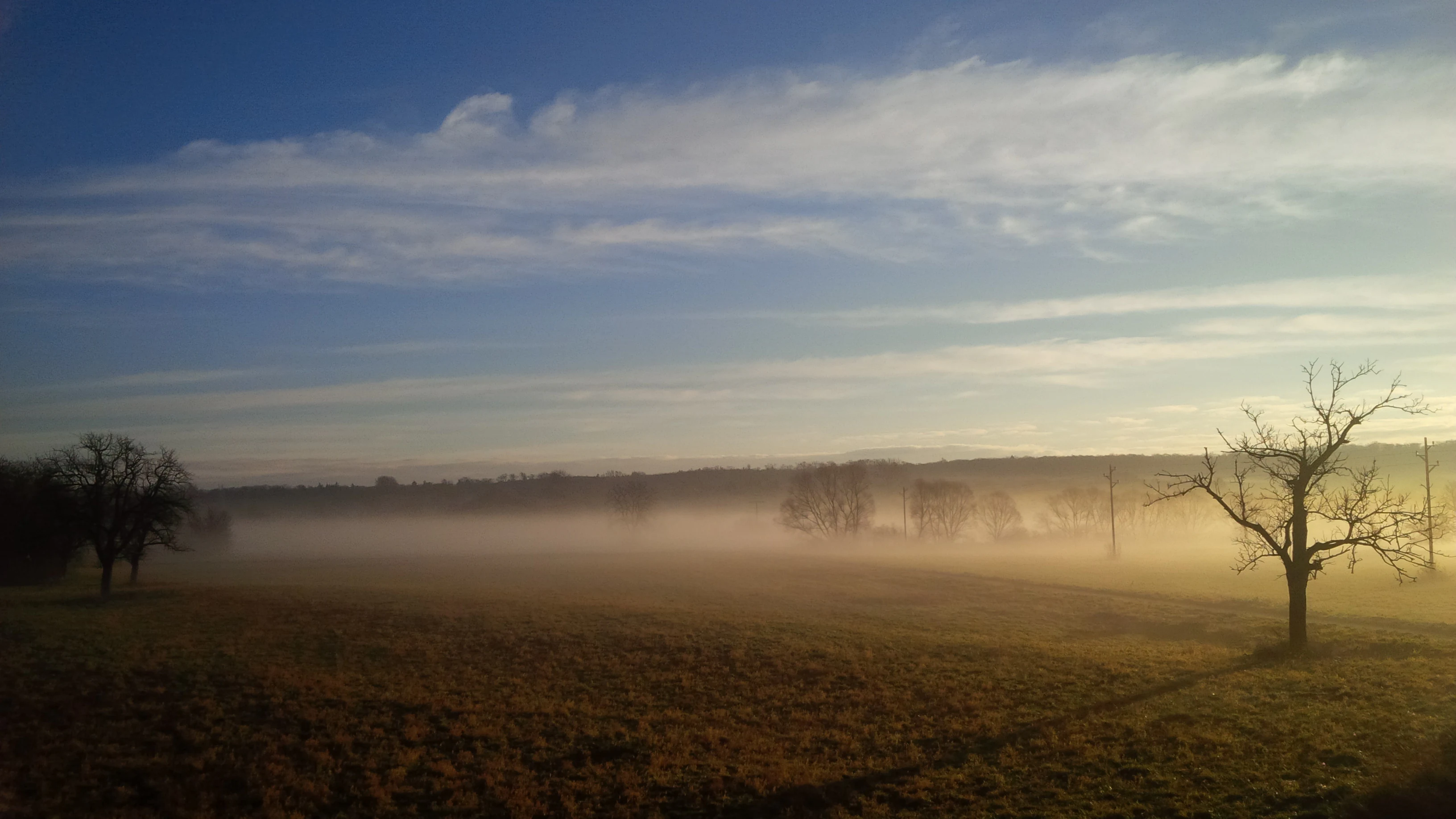
A wide, low-angle view of a flat meadow during golden hour, with thick fog clinging to the ground and silhouetted leafless trees on the horizon and in the foreground.
A misty meadow scene in the Um die Großwiese landscape protection area.

Um die Großwiese history and protected-area timeline

Um die Großwiese was formally designated as a protected landscape on 19 October 1990 through an ordinance issued by the Landratsamt Karlsruhe. The ordinance established the boundaries and conservation aims that still define the area today. Its creation reflects the broader tradition in Baden-Württemberg of using the Landschaftsschutzgebiet category to safeguard medium-sized cultural and ecological landscapes, rather than smaller natural monuments or strictly managed nature reserves.

The protection order explicitly emphasizes preserving a large, continuous meadow area with moist meadows, traditional orchards, and streamside woodland, alongside the maintenance of grassland, vineyards, and forest. It also names the area's role for Nah- und Kurerholung, or local and curative recreation, which connects the designation to Bad Schönborn's identity as a spa municipality. Subsequent integration with the FFH area Nördlicher Kraichgau has further anchored the site's significance within European habitat protection frameworks, though the foundational story remains a 1990 regional landscape protection designation.

Um die Großwiese landscape and geographic character

The protected area sits within the gently undulating foothills, or Vorbergzone, of the northern Kraichgau. This is a transitional landscape between the higher Kraichgau plateau and the Rhine plain, characterized by rolling relief, mixed land use, and a mosaic of small-scale habitat types rather than dramatic elevation. Within Um die Großwiese, this transitional character is expressed through the layering of meadowland, orchard strips, hedgerows, vineyards, and forest entries, all visible within a compact area.

The eastern part of the area contains a closed forest block in which the sessile oak and hornbeam association, a classic Central European woodland type, is preserved both for biodiversity and as recreation forest for the local population. Small brooks, including the Gründelgraben along the boundary, contribute riparian woodland strips and moist meadow fringes near the edges of the reserve. Vineyards occupy parts of the southern and central slopes, fitting the Kraichgau's long tradition of wine growing, while species-rich meadows and traditional orchards fill the remaining open ground. The overall terrain is mild and walkable, with the typical Kraichgau mix of arable recall, orchard lattice, and forest edge dictating the visual rhythm of the protected landscape.

Um die Großwiese ecosystems, habitats, and plant life

Um die Großwiese protects a representative slice of the Kraichgau's semi-natural cultural landscape, with emphasis on species-rich Grünland (grassland), moist meadows, traditional orchards, hedgerow networks, and small watercourses. The habitat mosaic is intentionally varied: open meadows provide grassland habitat, Streuobst orchards contribute old-growth tree features and dead wood, field hedges add structural connectivity, and streams with gallery woodland link aquatic and terrestrial habitats.

The eastern forest block is a particular ecological anchor, where the Traubeneichen-Hainbuchen-Wald, or sessile oak-hornbeam forest, is highlighted as a habitat to conserve. This forest type supports characteristic woodland flora and a layered canopy structure. The Gründelgraben and associated brook corridors extend moist conditions into the otherwise relatively dry Kraichgau terrain, supporting riparian vegetation and likely richer invertebrate and amphibian habitat. The inclusion of the natural monument Magerwiese Pfarrwald, a lean meadow, adds open-ground specialist habitat, while overlap with the FFH area Nördlicher Kraichgau extends the site's ecological relevance to habitat types of European interest.

Um die Großwiese wildlife and species highlights

The protected area is less a single-species wildlife site than a structured habitat complex whose mosaic of meadows, orchards, hedgerows, brooks, and oak-hornbeam forest supports a broad range of regional species. The combination of open grassland, traditional orchard trees with cavity and bark features, riparian woodland along the brooks, and closed forest on the eastern side creates nesting, foraging, and shelter opportunities for typical Kraichgau fauna, including common birdlife, small mammals, insects tied to traditional orchard and meadow habitats, and amphibians along the Gründelgraben and other small watercourses.

The site's overlap with the FFH area Nördlicher Kraichgau suggests that some habitats within or adjacent to Um die Großwiese may host species of European conservation interest, though the protected landscape itself is framed primarily in terms of habitat and landscape integrity rather than specific charismatic fauna. The traditional orchard meadows, in particular, are widely recognized in the region as important for invertebrates, hole-nesting birds, and bats, while the streamside woodland offers habitat connectivity for less mobile species.

Um die Großwiese conservation status and protection priorities

Um die Großwiese is, at its core, a regional instrument for preserving a representative Kraichgau cultural and ecological landscape. Its conservation purpose goes beyond a single habitat type: the protecting ordinance ties together the maintenance of species-rich meadows, moist meadows, traditional orchards, hedgerows, riparian woodland, vineyards, and a sessile oak-hornbeam forest, all within a single management vision. This integrated purpose is intended to keep the area's patchwork character intact rather than allowing one land use to dominate.

The site is also significant because it overlaps with the European FFH site Nördlicher Kraichgau, making it part of the Natura 2000 ecological network and giving its habitats a continental-scale conservation framing. The presence of the natural monument Magerwiese Pfarrwald within the protected area adds a stricter conservation layer for a particularly valuable open-ground habitat. Administration by the Landratsamt Karlsruhe and registration in both the Baden-Württemberg Schutzgebietsverzeichnis (identifier 2.15.052) and the World Database on Protected Areas (WDPA 325275) reflect its recognized standing in regional and international protected-area inventories.

Um die Großwiese cultural meaning and human context

The protected area sits within a working cultural landscape that has shaped the Kraichgau identity for centuries. Vineyards, traditional orchards, small meadows, and patches of forest are all part of the region's mixed agricultural heritage, and the protection ordinance explicitly references maintaining both the rural economy and the high scenic quality this mosaic produces. The designation's mention of Nah- und Kurerholung, or local and curative recreation, ties the landscape directly to Bad Schönborn's identity as a health resort community, where accessible green surroundings are part of the town's therapeutic appeal.

By preserving Streuobst and traditional grassland alongside vineyards, the protected landscape also sustains elements of regional food culture, local orchard traditions, and the longstanding visual character of the northern Kraichgau foothills. Although no specific indigenous or community management story is documented in the available source, the area's continued agricultural use implies an ongoing relationship between local residents, farmers, and the surrounding landscape that the protection is designed to support rather than exclude.

Top sights and standout views in Um die Großwiese

Um die Großwiese is notable for packing several classic Kraichgau landscape elements into one protected perimeter: species-rich meadows, traditional Streuobst orchards, field hedgerows, brooks with riparian gallery woodland, vineyards, and a closed oak-hornbeam forest. Its boundaries, anchored by the B 292 to the north and the Gründelgraben stream to the east, frame a coherent cultural landscape rather than a fragmented set of features.

The area's formal recognition spans multiple levels: regional landscape protection since 1990, inclusion within the FFH site Nördlicher Kraichgau, and listing in both the Baden-Württemberg Schutzgebietsverzeichnis and the World Database on Protected Areas. Its dual role as a conservation landscape and an officially recognized recreation area for the Bad Schönborn spa community gives it both ecological and social significance within the Landkreis Karlsruhe.

Best time to visit Um die Großwiese

Because Um die Großwiese is a cultural and ecological landscape rather than a heavily programmed visitor site, the experience shifts with the seasons in the same way the surrounding Kraichgau does. Spring and early summer bring fresh green meadows, blossoming traditional orchards, and active birdlife around hedgerows and stream corridors, while late spring into summer is when the species-rich meadows are at their most visually expressive. Late summer and early autumn align with the harvest season in the surrounding vineyards and orchards, giving the landscape its warmest, most productive character.

For quieter, contemplative walks through the oak-hornbeam forest and riparian strips, the cooler months of autumn and early winter offer softer light, fewer visitors, and a clearer view of the structural features of the landscape, such as hedgerow networks, solitary orchard trees, and the forest edge. Throughout the year, the accessible, low-relief terrain and the area's connection to Bad Schönborn's recreation function make it suitable for unhurried local exploration rather than time-critical visits.

Monthly climate preview

Track representative monthly temperature averages and precipitation rates for Um die Großwiese

Um die Großwiese Climate Normals and Long-Term Temperature Patterns

Long-term representative coordinate records outline the measured annual temperature rhythm and monthly precipitation patterns across Um die Großwiese. Reviewing the complete twelve-month statistical baseline provides clear context for comparing long-term climate normals.
Annual mean9 °C
0 °C20 °C
Jan
Feb
Mar
Apr
May13°
Jun17°
Jul20°
Aug19°
Sep15°
Oct10°
Nov
Dec
Warmest month
July

19.6 °C

Coolest month
January

-0 °C

Wettest month
May

2.7 mm/day

Driest month
April

1.7 mm/day

Park location guide

Geography guide, regional context, and park location map for Um die Großwiese

Um die Großwiese park geography, regions, and map view in Germany

Understand where Um die Großwiese sits in Germany through a broader geographic reading of the surrounding landscape, nearby location context, and its mapped position within the national park landscape.

How Um die Großwiese fits into Germany

Germany is a federal republic in Western and Central Europe with a population of over 83 million across sixteen constituent states. It is Europe's largest economy by nominal GDP and a major global exporter and importer. The capital is Berlin, and the country borders Denmark, Poland, Czech Republic, Austria, Switzerland, France, Luxembourg, Belgium, and the Netherlands.

Wider geography shaping Um die Großwiese in Germany

Germany is located in Western and Central Europe, spanning 357,022 km². It borders Denmark to the north, Poland and the Czech Republic to the east, Austria and Switzerland to the south, and France, Luxembourg, Belgium, and the Netherlands to the west. The country has coastlines on the Baltic Sea and North Sea to the north, with the Alps located in the southern region.

Map view of Um die Großwiese

Use this park location map to pinpoint Um die Großwiese in Germany, understand its exact geographic position, and read its mapped placement within the surrounding landscape more clearly.

Pigeon | © OpenStreetMap contributors

Location context for Um die Großwiese

Baden-WürttembergLandkreis Karlsruhe

Explore visual records of the Kraichgau foothills, traditional orchards, and forest mosaics.

Um die Großwiese Photos and Landscapes: Visual Guide to Protected Scenery

Visual documentation captures the undulating terrain, protected meadowlands, and diverse woodland habitats of Um die Großwiese. Examining these landscape photographs helps reveal the ecological composition and structural character of this protected regional environment.

A wide, low-angle view of a flat meadow during golden hour, with thick fog clinging to the ground and silhouetted leafless trees on the horizon and in the foreground.

Park atlas

Compare surrounding regional park geography and adjacent foothill reserves

Parks Near Um die Großwiese and Related Protected Landscapes in Baden-Württemberg

Browse other protected areas and regional reserves located near Um die Großwiese across the northern Kraichgau foothills. Comparing adjacent conservation landscapes provides broader context on local meadow networks and woodland habitats.
A watercolor painting showing a rolling landscape with purple hills, green vegetation, and light yellow fields.
Protected landscapeBaden-Württemberg
About 8.5 km away#1 closest

West

Obere Lußhardt Protected Landscape: Geography and Regional Woodland Mapping

A study of forest biotopes and meadow stream corridors

The Obere Lußhardt area stands as a central protected landscape on the Hardt plain, spanning municipalities within the Baden-Württemberg district. Through forest conservation and open grassland corridors like the Gemswiesen, the site provides a distinct look at the transition between Rhine lowland forest and local stream valley ecology.

Area
5.862 km²
Established
1973
IUCN
V
Relief
Lowland
A soft watercolor illustration of a rolling meadow landscape featuring green grasses and pink flowers against a light background.
Protected landscapeBaden-Württemberg
About 9.7 km away#2 closest

West

Hambrücker Wiesen Protected Landscape: A Geographical Atlas of Baden-Württemberg Terrain

Mapped meadows, wetland corridors, and regional landscape boundaries

Spanning 107 hectares in the Hardtebenen, Hambrücker Wiesen functions as a critical protected landscape in Baden-Württemberg. The area anchors a diverse geographic profile featuring lowland hay meadows, reed beds along the Wagbach, and open agricultural terrain. Discover how this site integrates into the broader network of protected zones within the Upper Rhine Plain while preserving its traditional rural character against development.

Area
1.066 km²
Established
1991
IUCN
V
Relief
Lowland
A pale, minimalist watercolor painting showing a wide river flowing through a lush green floodplain with rolling hills in the background.
Nature reserveRhineland-Palatinate
About 17 km away#3 closest

Northwest

Speyerer Auwald Nature Reserve: Protected Alluvial Forest Geography in Rhineland-Palatinate

An essential Rhine valley floodplain and habitat mosaic

Located along the Upper Rhine, the Speyerer Auwald encompasses a vital protected landscape of alluvial forests, relic oxbows, and traditional meadows. This record traces the park boundaries, hydrological features, and the distinct ecological zones that make this floodplain forest a cornerstone of the regional geography in Rhineland-Palatinate.

Relief
Lowland
Climate
Temperate
Access
Easy access
Scope
Terrestrial
Nature reserveRheinland-Pfalz
About 19 km away#4 closest

Northwest

Flotzgrün Nature Reserve: Protected Floodplain Landscapes and Rhine Geography in Rheinland-Pfalz

Mapping historical island creation and modern conservation polders

Flotzgrün serves as a compelling geographic entity within the Upper Rhine, functioning as both an active flood management polder and a protected riparian environment. This site offers insights into the intersection of 19th-century river straightening and modern ecological restoration, revealing a landscape defined by controlled wetlands, old river arms, and managed floodplain habitats.

Area
3.4 km²
Relief
Lowland
Scope
Terrestrial
Water
Major water bodies
A horizontal watercolor painting depicting a soft-focus landscape with a central tree, calm water, and rolling hills in the background.
Nature reserveRhineland-Palatinate
About 20 km away#5 closest

West

Brückenkopf Nature Reserve: An Atlas of Protected Floodplain Geography in Rhineland-Palatinate

Detailed mapping of rare wetland habitats and regional floodplain zones

Brückenkopf offers a unique look at small-scale habitat conservation in the Germersheim district. This nature reserve protects a vital fragment of the Upper Rhine floodplain, serving as a sanctuary for specific wetland flora and rare invertebrates. Gain a better understanding of its location between major infrastructure corridors and the river, marking it as a significant component of regional conservation strategy.

Area
0.357 km²
Established
1982
IUCN
IV
Relief
Lowland
A pale, atmospheric watercolor painting showing a quiet river scene with green trees and a hanging branch in the foreground, rendered in a light and airy style.
Nature reserveRhineland-Palatinate
About 21 km away#6 closest

West

Schwarzwald Nature Reserve: A Protected Rhine Floodplain Landscape in Rhineland-Palatinate

Geographic atlas of alluvial forests and oxbow river dynamics

Schwarzwald represents a significant nature reserve in Germany, characterized by its position between the modern Rhine and the Lingenfelder Altrhein. The area contains a rich collection of floodplain features, including alluvial forests, pollarded willows, and standing gravel pit lakes, offering a comprehensive look at the riparian geography of the Upper Rhine.

Area
3.41 km²
Established
1997
Protected landscapeBaden-Württemberg
About 21 km away#7 closest

Southwest

Weingartener Wiesental Protected Landscape: Geography and Meadow Valley Overview

Historic irrigation heritage in the Baden-Württemberg region.

The Weingartener Wiesental provides a clear example of a managed meadow valley landscape, featuring an extensive network of historical irrigation ditches and a surviving aqueduct. Situated within the Hardtebenen natural region, this protected area serves as an ecological buffer and a window into the traditional land management practices characteristic of the Kinzig-Murg-Rinne river corridor.

Area
1.109 km²
Established
1991
IUCN
V
Relief
Lowland
Watercolor painting of a tranquil wetland landscape with soft green vegetation and a calm water body, reflecting the floodplain environment of the Rhine river.
Nature reserveLandkreis Germersheim
About 21 km away#8 closest

West

Hördter Rheinaue Nature Reserve: Landscape and Geographic Context in Landkreis Germersheim

Examining the hydrology and floodplain forest of the German Rhine.

Hördter Rheinaue serves as a critical node in the Palatinate Rhine floodplains, preserving a vast mosaic of willow and poplar forests alongside stable hardwood stands. Analyze the mapped terrain shaped by centuries of river activity, including the meandering Michelsbach and associated oxbow systems that define this essential protected corridor in western Germany.

Area
8.18 km²
Established
1966
IUCN
IV
Relief
Lowland

Common questions about visiting, size, designation, and location context for Um die Großwiese

Um die Großwiese FAQs for park facts, access, geography, and protected area context

Find quick answers about Um die Großwiese, including protected-area facts, park geography, trail and visitor context, and how the park fits into its surrounding country and regional landscape.
MoriAtlas Explorer

Continue Your Protected Areas Search Across the Global Atlas

Deepen your exploration by continuing the structured search for national parks and protected areas worldwide. Utilize the comprehensive filtering capabilities to compare different conservation landscapes and refine your understanding of global park geography. Discover more about the distribution and characteristics of protected natural areas.

Global natural geography