
Mori Atlas logo
Nature reserveUnterer Großhartmannsdorfer Teich

A study of artificial wetland landscapes, sixteenth-century mining water systems, and protected habitats in Saxony

Unterer Großhartmannsdorfer Teich: Mapped Geography of the Historic Ore Mountains Nature Reserve

Unterer Großhartmannsdorfer Teich stands as the largest historic mining reservoir within the Freiberg water management system in Saxony, Germany. This protected nature reserve integrates deep industrial heritage with a rich ecological mosaic of peat bogs, marshy shorelines, and aquatic habitats. The site functions as a key component of the Natura 2000 network, offering essential insights into the intersection of early modern engineering and contemporary conservation of wetland biodiversity.

Ore MountainsSaxonyReservoirMining heritageArtisanal mining pondNature reserve
A flat, vector-style illustration of a winding river flowing through a forested mountain valley with a small village in the distance under a bright sun.

Unterer Großhartmannsdorfer Teich

Nature reserve

Park overview

Structured park overview, official facts, and landscape profile for Unterer Großhartmannsdorfer Teich

Unterer Großhartmannsdorfer Teich park facts, protected area profile, and essential visitor context

Review the core facts for Unterer Großhartmannsdorfer Teich, including designation, size, terrain, visitor scale, habitats, and operating context in one park-focused overview.

About Unterer Großhartmannsdorfer Teich

The Untere Großhartmannsdorfer Teich is a large historic reservoir in the eastern German Ore Mountains (Erzgebirge), located in the Landkreis Mittelsachsen in Saxony. It belongs to the Revierwasserlaufanstalt Freiberg, a centuries-old network of ponds, ditches, and tunnels originally designed to keep the silver mines around Freiberg supplied with process water even during dry periods.

The reservoir lies northeast of Großhartmannsdorf, between that village and Helbigsdorf, set in a gently rolling section of the upper Ore Mountains. Its catchment is fed by the Großhartmannsdorfer Dorfbach, the Kuhbach, and the Zethauer Kunstgraben, and the pond is further connected by small mine drainage tunnels (Röschen) and artificial channels to the Obere Großhartmannsdorfer Teich uphill, the Mittlerer Großhartmannsdorfer Teich downstream, and the nearby Rothbächer Teich. Together these waters form a tightly engineered mining landscape that has reshaped the local hydrology for more than four hundred years.

The dam is an earthen structure with a clay core seal and a water-facing tarras masonry wall, reflecting the traditional RWA construction style. Originally built between 1568 and 1572 on the site of a boggy depression with a small millpond, the dam has been raised repeatedly over the centuries, reaching a current crest length near 492 meters and a water surface of more than sixty hectares. While the reservoir's original purpose of supplying water to stamping mills and ore washhouses has faded along with the Freiberg mining industry, the pond today provides operational water and modest flood protection, and supports an active carp-based fishery that has continued since the earliest period of the pond's existence.

Surrounding the open water are relic peatland areas with peat layers up to three meters thick, historically worked for fuel and famously illustrated in Hans Carl von Carlowitz's classic Sylvicultura Oeconomica. Intensive peat cutting shaped the local land use from the eighteenth century until it was halted in 1961 under growing nature conservation pressure, leaving behind a mosaic of bog remnants, moist meadows, and shoreline habitat that frames the reservoir today.

Quick facts and research context for Unterer Großhartmannsdorfer Teich

The Untere Großhartmannsdorfer Teich sits in Landkreis Mittelsachsen in Saxony, at the northeastern edge of the village of Großhartmannsdorf. It is the largest standing water body operated by the historic Freiberg mining water authority and remains one of the largest reservoirs in the Ore Mountains alongside later twentieth-century dams.

The dam was constructed beginning in 1568 as an artisanal mining pond (Kunstteich), and the present-day embankment is roughly 492 meters long with a storage capacity of over 1.6 million cubic meters. The reservoir is fed by the Großhartmannsdorfer Dorfbach, the Kuhbach, and the Zethauer Kunstgraben, and is hydrologically linked to the Obere, Mittlere Großhartmannsdorfer Teich, and Rothbächer Teich through small drainage tunnels and artificial channels.

Protection and recognition

Terrestrial protected area records established in 1967

Unterer Großhartmannsdorfer Teich Protection Status and Designation History

Unterer Großhartmannsdorfer Teich holds a documented terrestrial protection status established in 1967. Protected area records outline the management scope and historical designation data for this location.

Protection details

Protection scope
Terrestrial
Designated year
1967
Transboundary protection
No
Park context

Deeper park guide and search-rich context for Unterer Großhartmannsdorfer Teich

Unterer Großhartmannsdorfer Teich history, landscape, wildlife, and travel context

Explore Unterer Großhartmannsdorfer Teich through its history, landscape character, ecosystems, wildlife, conservation priorities, cultural context, and seasonal travel timing in a structured park guide built for atlas discovery and search intent.

Why Unterer Großhartmannsdorfer Teich stands out

The reservoir is best known as the largest historic mining pond of the Freiberg Revierwasserlaufanstalt, an extensive artificial water system that once powered ore processing, stamp mills, and water wheels around the Freiberg silver mines. The site is equally recognized for its rich wetland character, with surrounding peat bogs, marshy shorelines, and reed beds that support a major waterbird population. Its combination of sixteenth-century industrial heritage and modern nature protection status, including Natura 2000 designation through the Freiberger Bergwerksteiche habitat area, makes it a distinctive cultural and ecological landmark in the Ore Mountains.
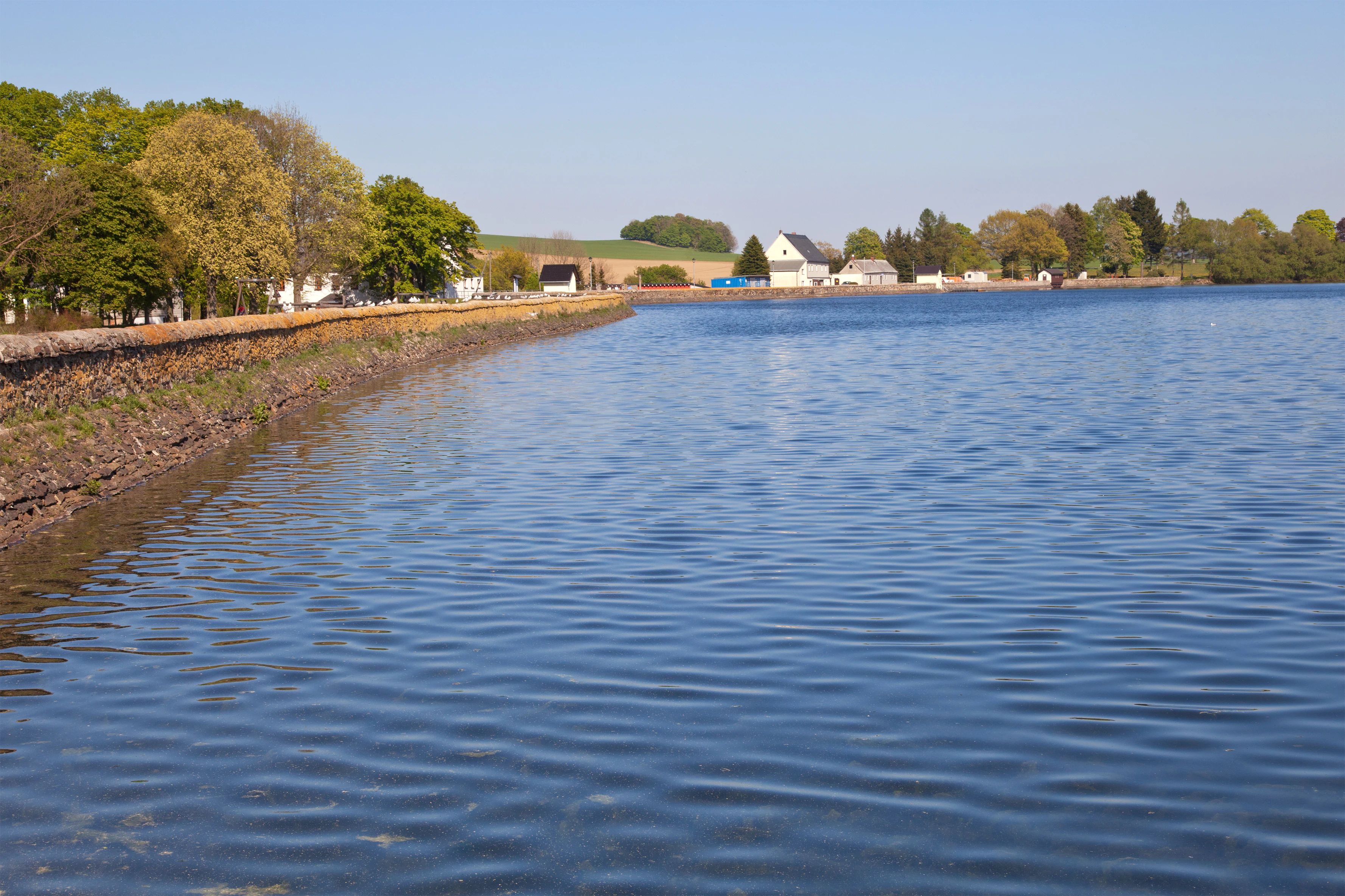
A wide angle view of a calm blue reservoir with a stone embankment wall on the left, leading to a small village with houses and trees in the distance under a clear sky.
A view along the historic reservoir embankment at Unterer Großhartmannsdorfer Teich.

Unterer Großhartmannsdorfer Teich history and protected-area timeline

The history of the Untere Großhartmannsdorfer Teich reaches back to the second half of the sixteenth century, when Saxon mining engineers sought to secure a reliable supply of Aufschlagwasser, the drive water for water wheels and stamp mills at the silver mines near Freiberg. In 1568 construction began on what had until then been a small millpond in a boggy depression, and between 1568 and 1572 the site was transformed into a Kunstteich, an artificial mining pond engineered to retain water through dry seasons.

Over the following centuries the dam was progressively raised to increase storage, and additional water was channeled in from the Großhartmannsdorfer Dorfbach, the Kuhbach, and the Zethauer Kunstgraben. Small drainage tunnels and connecting ditches integrated the pond with neighboring reservoirs in the wider RWA system, creating an interconnected network of mine water infrastructure across the upper Ore Mountains.

While the pond fulfilled its industrial purpose, the surrounding peat bogs became a local resource in their own right. From the eighteenth century onward, the peat deposits up to three meters thick were intensively cut for fuel, a practice documented in the famous forestry treatise Sylvicultura Oeconomica by Hans Carl von Carlowitz. Peat extraction continued into the twentieth century but was finally halted in 1961 under pressure from nature conservation interests.

With the decline of the Freiberg mining industry, the reservoir's role as a source of mining water ended. The pond was repurposed for operational water supply and modest flood control, while the long tradition of fish farming, especially carp, continued. In 1967 the area was officially designated as a nature reserve (Naturschutzgebiet), initially covering 110 hectares, and was expanded by another 45 hectares in 1997, formalizing its modern role as both industrial heritage and protected landscape.

Unterer Großhartmannsdorfer Teich landscape and geographic character

The Untere Großhartmannsdorfer Teich occupies a gently sloped basin in the eastern Ore Mountains, where rolling upland terrain has been shaped by centuries of water engineering. The dam forms a long, low earthen ridge across the valley, with a traditionally built water-side masonry face (Tarrasmauer) and a clay-sealed core, producing a broad, shallow reservoir rather than a deep alpine lake.

Around the open water, the landscape transitions into a mosaic of relict peat bogs, moist meadows, and shoreline marsh. The peat deposits in the surrounding ground reach depths of up to three meters and bear visible traces of past turf cutting, including the small drainage patterns and exposed peat faces that mark former extraction areas. Westward, the village of Großhartmannsdorf lies close to the dam, while the settlement of Helbigsdorf marks the eastern flank of the reservoir basin. The broader setting reflects the early modern industrial character of the Saxon Ore Mountains, where ponds, ditches, and tunnels sit within an otherwise rural, forested upland.

Unterer Großhartmannsdorfer Teich ecosystems, habitats, and plant life

Ecologically, the Untere Großhartmannsdorfer Teich is defined by the interplay between open water, wetland margins, and surrounding peat relicts, producing a layered habitat structure unusual for a historically engineered mining pond. The plant inventory of the protected area includes roughly 260 species, ranging from typical wetland vegetation such as scheidgras (sedge-like grasses) and schlammkraut (mudwort) to bog specialists like moorbirke (bog birch) and moosbeeren (bog cranberries).

The boggy zones around the pond retain a community of moisture-loving plants adapted to acidic, nutrient-poor peat soils, while the water margin develops reed and sedge communities that grade into the broader meadow and woodland matrix of the upper Ore Mountains. Because the pond sits at the head of an interconnected water system, its hydrology is shaped not just by local weather but by the regulated flow of neighboring reservoirs, the Zethauer Kunstgraben, and the historic drainage tunnels.

Unterer Großhartmannsdorfer Teich wildlife and species highlights

The reservoir is widely recognized as a significant breeding, molting, and resting site for waterfowl and marsh birds. Regular visitors and residents include mallard, teal, pochard, and tufted duck, alongside grebes such as great crested grebe, little grebe, and black-necked grebe. Other notable species recorded at the site include water rail, black tern, and dunlin, marking the pond as a regionally important wetland for migratory and breeding birds alike.

Bats also make use of the rich insect populations over the water and along the shoreline. In the open water itself, fish stocking for aquaculture has established populations of carp, tench, pike, rudd, and pikeperch. Amphibians such as common frog, pool frog, and moor frog, along with common toad, smooth newt, and alpine newt, use the margins and adjacent bog habitats, and grass snakes have been recorded around the pond.

Invertebrate surveys have documented over seventy spider species, around 146 butterfly and moth species, fourteen ground beetle species, and twelve grasshopper species, while the dragonfly fauna alone includes twenty-nine species, among them broad-bodied chaser, four-spotted chaser, and emperor dragonfly. Among mammals, the surroundings harbor harvest mouse, polecat, American mink, and, notably, Eurasian otter, signaling the continued ecological connectivity of the wetland system.

Unterer Großhartmannsdorfer Teich conservation status and protection priorities

The Untere Großhartmannsdorfer Teich has been formally protected as a Naturschutzgebiet since 1967, originally covering 110 hectares, and was expanded by an additional 45 hectares in 1997. It forms part of the larger Freiberger Bergwerksteiche Fauna-Flora-Habitat area, linking it into the European Natura 2000 network and giving it standing as a site of community importance for habitat conservation.

The area's conservation significance lies in the combination of open water, peatland remnants, and cultural landscape features that together sustain a rich community of wetland plants, breeding waterbirds, amphibians, bats, and invertebrates. The presence of sensitive bog species, large numbers of waterfowl, and the otter population demonstrates the continuing ecological value of the site, while the tension between its history of peat exploitation and modern protection reflects the broader narrative of land-use change in the Ore Mountains.

Unterer Großhartmannsdorfer Teich cultural meaning and human context

The reservoir is deeply woven into the cultural and industrial history of the Freiberg mining region. Built to keep the medieval and early modern silver mines operational during dry periods, it represents a tangible expression of how the Saxon state and mining administration engineered entire landscapes to sustain underground wealth. The pond's role in supporting fish farming since its earliest years further connects it to long-standing rural traditions of pond management in the Erzgebirge.

The surrounding peat bogs carry their own cultural imprint. Their intensive use as a fuel source from the eighteenth century onward left both physical scars in the landscape and a documented place in the history of forestry and resource management, most famously through Hans Carl von Carlowitz's Sylvicultura Oeconomica, one of the foundational texts of sustainable forestry. The eventual halt of peat cutting on conservation grounds in 1961 marks a transition from extraction to preservation that defines the modern cultural reading of the site.

Top sights and standout views in Unterer Großhartmannsdorfer Teich

Within the Freiberg mining water system, the Untere Großhartmannsdorfer Teich stands out for its sheer scale, with a dam close to half a kilometer long and a water surface exceeding sixty hectares, making it the largest historic mining pond commanded by the RWA. Its sixteenth-century origins, continuous modifications over four centuries, and survival as a working industrial water body give it unusual historical depth among Ore Mountains reservoirs.

Ecologically, the combination of open water, surrounding peat relicts, and a protected-area status since 1967 has produced a rich wetland mosaic. The site is a regional stronghold for breeding and migrating waterbirds, supports a wide cast of amphibians, bats, and invertebrates, and hosts an otter population, all of which mark it as a notable conservation area within the Saxon mining landscape.

Best time to visit Unterer Großhartmannsdorfer Teich

The reservoir and its surroundings offer distinct seasonal character throughout the year. Late spring and early summer are typically the most rewarding periods for observing breeding waterbirds, singing marsh birds, and active amphibians along the shoreline, while the vegetation around the bog relicts is at its most visible.

Late summer and early autumn tend to be productive for migratory and staging waterfowl, when the pond functions as a resting stop for ducks, grebes, and waders. Winter brings a quieter atmosphere, with reduced vegetation cover that can make the reservoir's waterbird and mammal life easier to observe from the surrounding paths, while the surrounding Ore Mountain villages retain their traditional character year-round.

Monthly climate preview

Long-term representative monthly temperature and precipitation data for Saxony

Unterer Großhartmannsdorfer Teich Climate Normals and Annual Temperature Rhythm

Representative coordinates record measured monthly temperature and precipitation variations across the representative elevation of Unterer Großhartmannsdorfer Teich. Deeper twelve-month climate profiles supply complete long-term averages for detailed regional comparison.
Annual mean9 °C
-1 °C19 °C
Jan-1°
Feb
Mar
Apr
May13°
Jun17°
Jul19°
Aug19°
Sep14°
Oct
Nov
Dec
Warmest month
July

18.9 °C

Coolest month
January

-1.4 °C

Wettest month
July

2.8 mm/day

Driest month
April

1.3 mm/day

Park location guide

Geography guide, regional context, and park location map for Unterer Großhartmannsdorfer Teich

Unterer Großhartmannsdorfer Teich park geography, regions, and map view in Germany

Understand where Unterer Großhartmannsdorfer Teich sits in Germany through a broader geographic reading of the surrounding landscape, nearby location context, and its mapped position within the national park landscape.

How Unterer Großhartmannsdorfer Teich fits into Germany

Germany is a federal republic in Western and Central Europe with a population of over 83 million across sixteen constituent states. It is Europe's largest economy by nominal GDP and a major global exporter and importer. The capital is Berlin, and the country borders Denmark, Poland, Czech Republic, Austria, Switzerland, France, Luxembourg, Belgium, and the Netherlands.

Wider geography shaping Unterer Großhartmannsdorfer Teich in Germany

Germany is located in Western and Central Europe, spanning 357,022 km². It borders Denmark to the north, Poland and the Czech Republic to the east, Austria and Switzerland to the south, and France, Luxembourg, Belgium, and the Netherlands to the west. The country has coastlines on the Baltic Sea and North Sea to the north, with the Alps located in the southern region.

Map view of Unterer Großhartmannsdorfer Teich

Use this park location map to pinpoint Unterer Großhartmannsdorfer Teich in Germany, understand its exact geographic position, and read its mapped placement within the surrounding landscape more clearly.

Pigeon | © OpenStreetMap contributors

Location context for Unterer Großhartmannsdorfer Teich

Saxony

Visual exploration of historic reservoir waters, peatlands, and upland habitats

Unterer Großhartmannsdorfer Teich Photos and Landscape Scenery

Visual records reveal the expansive water surface, earthen dam engineering, and surrounding peatland mosaics that define the protected reservoir basin. Photographic documentation captures the distinct wetland character and historic industrial topography of the Ore Mountains landscape.

A wide angle view of a calm blue reservoir with a stone embankment wall on the left, leading to a small village with houses and trees in the distance under a clear sky.

Park atlas

Compare surrounding regional reserves and connected historic water landscapes

Other Parks and Protected Areas Near Unterer Großhartmannsdorfer Teich

Visitors exploring Unterer Großhartmannsdorfer Teich can browse adjacent protected areas and regional reserves across the Ore Mountains. These connected locations provide broader geographic context for comparing wetland habitats and historic water management networks.
Nature reserveSachsen
About 11 km away#1 closest

East

Gimmlitztal Nature Reserve in the Ore Mountains: Mapped Protected Landscapes

Exploring the stream valley geography of Saxony, Germany.

Gimmlitztal is a significant nature reserve in the German state of Saxony that protects the unique hydrology and biodiversity of the Gimmlitz stream corridor. The terrain includes forested slopes and traditional meadow patches, reflecting a long history of human interaction with the Ore Mountain environment. This reserve functions as a continuous green ribbon for regional habitat preservation.

Area
2.578 km²
Established
2015
IUCN
IV
Nature reserveSaxony
About 22 km away#2 closest

Northeast

Weißeritztalhänge Nature Reserve: Protected Slope Forests and River Valley Geography

Regional landscape profile in Saxony, Germany

Weißeritztalhänge represents a significant nature reserve situated along the Wilde Weißeritz in Saxony. The protected area features expansive slope forests that transition from the Saxon lowlands into the Erzgebirge, providing a critical refuge for diverse woodland and river-dwelling species.

Area
4.486 km²
Established
1961
IUCN
IV
Relief
Upland
Nature reserveSachsen
About 24 km away#3 closest

West

Um den Eibsee: A Detailed Atlas and Geographic Overview of the Saxony Nature Reserve

Examining the terrain, lake basin, and regional landscape context.

Located near Chemnitz, the Um den Eibsee nature reserve represents a managed cultural landscape spanning 39 hectares. This area integrates the Eibsee lake with surrounding open pastures, protected specifically to prevent habitat loss through active conservation grazing. Gain insights into the boundary mapping and ecological structure that define this unique Saxon protected area.

Area
0.39 km²
Established
2000
IUCN
IV
Relief
Lowland
Nature reserveSächsische Schweiz-Osterzgebirge
About 29 km away#4 closest

East

Weicholdswald Nature Reserve: Mapped Protected Landscapes of the Eastern Ore Mountains

A preserved beech forest enclave within the Sächsische Schweiz-Osterzgebirge

Weicholdswald stands as a primary nature reserve in the Sächsische Schweiz-Osterzgebirge district, known for its 160-year-old beech trees and extensive deadwood habitats. This protected area provides a rare look at near-natural forest ecosystems that have remained free from historic clear-cutting or coniferous monocultures, maintaining rich biodiversity across its streams and granitic slopes.

Area
1.037 km²
Established
1961
IUCN
IV
Watercolor painting of a peat bog with a small meandering stream, scattered deadwood, and a distant mountain range under a pale sky.
Nature reserveSachsen
About 29 km away#5 closest

East

Georgenfelder Hochmoor Nature Reserve: A Protected Highland Bog in the Ore Mountains

Examining the geography and mapped peatland terrain in the Sachsen region

Georgenfelder Hochmoor is a distinct ridge-top raised bog located on the high plateau of the Osterzgebirge. This protected area maintains a significant ten-thousand-year peat profile and plays a vital role in the watershed divide of the Ore Mountains, offering a clear example of modern transboundary conservation and mountain moorland development.

Area
0.135 km²
Established
1961
IUCN
IV
Visitors
17.5K annual
Nature reserveSaxony
About 29 km away#6 closest

South

Steinbach Nature Reserve: Regional Geography and Protected Landscape Map

Ecological connectivity in the Saxon Ore Mountains

Steinbach Nature Reserve encompasses a significant mosaic of beech, spruce, and floodplain forest communities across the Saxon Ore Mountains. This protected area plays an essential role in the ecological network of the Preßnitz catchment, where it preserves rare species and traditionally managed highland meadows within a distinct mountain terrain.

Area
4.406 km²
Established
2008
IUCN
IV
Relief
Highland
A soft watercolor illustration featuring a panoramic view of a peat bog landscape with evergreen trees and distant rolling mountains under a white background.
Nature reserveÚstecký kraj
About 30 km away#7 closest

East

Rašeliniště U jezera, Cínovecké rašeliniště: Protected Nature Reserve and Bog Landscape

Geography and environmental context in the Ústecký kraj mountain range.

Situated at high elevations in the Ore Mountains, Rašeliniště U jezera, Cínovecké rašeliniště protects a functioning example of a rare raised bog ecosystem. This reserve contains diverse bog-pool flora and peat-forming habitats, standing as a significant site for understanding the montane geography of northern Bohemia and the ongoing conservation of Krušné hory wilderness areas.

Area
0.601 km²
Established
2001
IUCN
IV
Relief
Mountain
Watercolor painting of a panoramic mountain landscape with rolling green hills, patches of forest, and distant peaks under a soft sky.
Nature reserveSaxony
About 31 km away#8 closest

East

Geisingberg Nature Reserve: A Volcanic Basalt Peak in the Eastern Ore Mountains of Saxony

Exploration of protected mountain terrain and volcanic geology

Geisingberg serves as a rare volcanic Quellkuppe rising above the Saxon mining landscapes of Altenberg. The nature reserve protects 300 hectares of high-altitude bogs, species-rich meadows, and historic forest clearings. Gain a deeper understanding of this mountain through detailed mapped terrain, topographic features, and long-standing protected-area status within the Ore Mountains.

Area
3 km²
Established
1960
Relief
Mountain
Climate
Temperate

Common questions about visiting, size, designation, and location context for Unterer Großhartmannsdorfer Teich

Unterer Großhartmannsdorfer Teich FAQs for park facts, access, geography, and protected area context

Find quick answers about Unterer Großhartmannsdorfer Teich, including protected-area facts, park geography, trail and visitor context, and how the park fits into its surrounding country and regional landscape.
MoriAtlas Explorer

Continue Your Protected Areas Search Across the Global Atlas

Deepen your exploration by continuing the structured search for national parks and protected areas worldwide. Utilize the comprehensive filtering capabilities to compare different conservation landscapes and refine your understanding of global park geography. Discover more about the distribution and characteristics of protected natural areas.

Global natural geography