

Mori Atlas logo
Nature reserveVápenka v Háji u Loučné pod Klínovcem

Examining the ecological value of dolomitic limestone terrain and historic lime kiln ruins.

Vápenka v Háji u Loučné pod Klínovcem: A Protected Nature Reserve in the Ore Mountains

(Přírodní památka Vápenka v Háji u Loučné pod Klínovcem)

Vápenka v Háji u Loučné pod Klínovcem represents a unique confluence of industrial history and high priority species conservation within the Ústecký kraj region. This protected area safeguards rare calcareous habitats on dolomitic bedrock, providing a sanctuary for critically endangered fungi and flora that thrive on mineral-rich substrates. The site serves as a vital case study in mountain terrain restoration and the persistence of rare botanical communities within the broader forested expanse of the Krušné hory.

Krušné horyOre Mountainsnatural monumentcalcareous habitatsdolomitic limestonerare flora
A flat-design illustration showing a mountain valley with steep cliffs, coniferous trees, waterfalls, and a river flowing through the center.

Vápenka v Háji u Loučné pod Klínovcem

Nature reserve

Park overview

Structured park overview, official facts, and landscape profile for Vápenka v Háji u Loučné pod Klínovcem

Vápenka v Háji u Loučné pod Klínovcem park facts, protected area profile, and essential visitor context

Review the core facts for Vápenka v Háji u Loučné pod Klínovcem, including designation, size, terrain, visitor scale, habitats, and operating context in one park-focused overview.

About Vápenka v Háji u Loučné pod Klínovcem

Vápenka v Háji u Loučné pod Klínovcem is one of the most recently designated protected areas in the Czech Krušné hory. Its formal category is přírodní památka, the national equivalent of a natural monument, and it is recorded under IUCN management Category IV, recognizing its role in conserving specific species and habitat features rather than entire ecosystems.

The protected area sits within the Klínovecká hornatina, a highland subsection of the Ore Mountains near Loučná pod Klínovcem. Geologically, the substrate is unusual for this part of the Krušné hory. Beneath the surface lie two-mica and muscovite schists, together with outcrops of dolomitic limestone. These calcareous rocks have driven the development of distinctive soils, including gley and peat-like profiles, which in turn support the rare flora and fungi that justify the site's protection.

The area's identity is inseparable from its industrial past. A lime kiln, founded around the mid-19th century by the Buquoy family who then owned the local estate, processed dolomitic limestone from the adjacent quarry. Quarrying continued until the mid-1920s. For a time the lime kiln complex and quarry remained open, with sheep grazing persisting into the 1980s, which helped keep the ground open and base-rich. After grazing and quarrying ceased, much of the surrounding land gradually became forested, largely through planted Norway spruce and later blue spruce and larch, particularly around 1990.

Today, Vápenka v Háji u Loučné pod Klínovcem functions as a compact conservation site that protects both the surviving ruins of the lime kiln, a piece of regional industrial heritage, and a tightly focused set of species and habitats. The area is crossed by the green-marked tourist trail between Háj and Kovářská, making it accessible to hikers exploring the broader Krušné hory landscape.

Quick facts and research context for Vápenka v Háji u Loučné pod Klínovcem

Vápenka v Háji u Loučné pod Klínovcem is a Czech přírodní památka (natural monument) classified under IUCN Category IV. It was designated on 24 February 2024 by the Krajský úřad Ústeckého kraje and covers 8.37 hectares. The site lies in the Krušné hory, specifically in the Klínovecká hornatina subunit and the Jáchymovská hornatina okrsek, in the Chomutov district of the Ústecký Region. Its defining character is shaped by a historical lime kiln and an associated former quarry on dolomitic limestone, where rare calcareous-flora species and fungi are protected.

Protection and recognition

Documented terrestrial protection history established in 2024

Vápenka v Háji u Loučné pod Klínovcem Protection Status and Designation Record

Vápenka v Háji u Loučné pod Klínovcem maintains documented terrestrial protection established through regional designation records in 2024. Structured conservation data details the official management scope and regulatory framework governing the protected landscape.

Protection details

Protection scope
Terrestrial
Designated year
2024
Transboundary protection
No
Park context

Deeper park guide and search-rich context for Vápenka v Háji u Loučné pod Klínovcem

Vápenka v Háji u Loučné pod Klínovcem history, landscape, wildlife, and travel context

Explore Vápenka v Háji u Loučné pod Klínovcem through its history, landscape character, ecosystems, wildlife, conservation priorities, cultural context, and seasonal travel timing in a structured park guide built for atlas discovery and search intent.

Why Vápenka v Háji u Loučné pod Klínovcem stands out

The monument is best known for its rare species assemblage on calcareous substrates created by historic limestone quarrying and burning. It supports strong populations of critically endangered plants such as Gentianella amarella subsp. amarella and Ophioglossum vulgatum, several orchid species including Gymnadenia conopsea and Epipactis atrorubens, and a distinctive community of critically endangered fungi tied to the dolomitic bedrock. It is also notable for being a small, ecologically focused protected area where centuries of human industrial activity, lime burning followed by sheep grazing and later spruce afforestation, have produced the exact open, base-rich conditions that these specialists require.
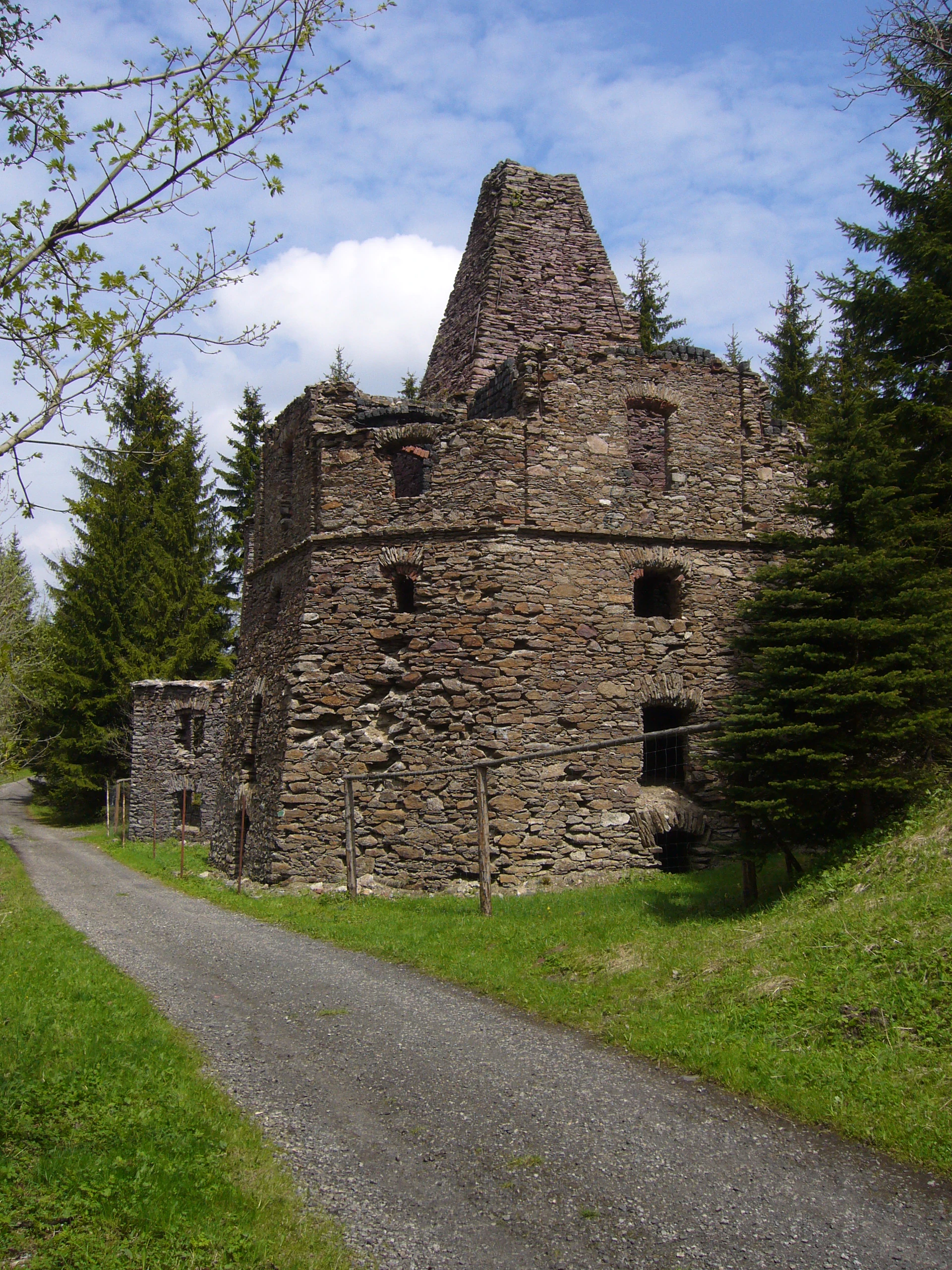
A weathered, multi-story stone lime kiln building with a tall chimney-like structure, situated next to a gravel path and surrounded by spruce trees under a partly cloudy sky.
The historic stone lime kiln in the nature reserve of Vápenka v Háji u Loučné pod Klínovcem.

Vápenka v Háji u Loučné pod Klínovcem history and protected-area timeline

The area's history is essentially the history of small-scale limestone industry in the northern Krušné hory. The lime kiln at Háj was established around the middle of the 19th century by the Buquoy family, former owners of the local estate, who used local dolomitic limestone from the adjacent quarry. The kiln operated for several decades, and quarrying of dolomitic limestone continued in parallel until the mid-1920s.

Even after industrial extraction stopped, the landscape around the kiln remained largely open. Sheep grazing continued in the former quarry and along the adjacent stream at least into the 1980s, helping to maintain clearings on the calcareous substrate. As grazing declined, Norway spruce began to spread across much of the surrounding former open ground from the mid-20th century onward, and around 1990 the quarry itself was planted with blue spruce, while some areas were additionally afforested with larch. Soil profiles were sometimes scraped back to bedrock before planting, leaving exposed calcareous ground.

Recognition of the site's conservation value came relatively late. Decades after the kiln and quarry fell silent, the Regional Authority of the Ústecký Region formally designated the area as a přírodní památka, with effect from 24 February 2024, protecting both the industrial heritage features and the rare species communities they support.

Vápenka v Háji u Loučné pod Klínovcem landscape and geographic character

The protected area lies within the Krušné hory, more specifically in the Klínovecká hornatina subunit and the Jáchymovská hornatina okrsek. The terrain reflects the rolling, mid-elevation character typical of this part of the Ore Mountains, with forested slopes and small valley systems.

The defining landscape features, however, are small-scale. The ruins of the historic lime kiln and the adjacent former quarry dominate the local topography, creating an unusual mix of exposed bedrock, mineral substrates, and recovering vegetation. The site is drained by the Černá voda stream, a tributary of the Přísečnice, which crosses the area before joining the larger watercourse downstream in Germany, near the settlement of Schmalzgrube. Drainage channels around the site lower groundwater levels and influence the hydrology of these small calcareous communities.

Surrounding the protected core is a matrix of spruce forest, much of it planted and partly dominated by blue spruce and larch, which frames the open, base-rich habitats and gives the protected area a distinct, abruptly open character within an otherwise forested upland landscape.

Vápenka v Háji u Loučné pod Klínovcem ecosystems, habitats, and plant life

Ecologically, the site is defined by calcareous conditions on dolomitic limestone within a wider acidic, spruce-dominated mountain environment. Soils developed on the limestone include gley soils and peat-like profiles, with groundwater influenced by old drainage channels. The combination of base-rich rock, historically grazed open ground, and cold mountain climate has produced a habitat mosaic that supports several specialized species.

Vegetation patterns shift sharply across short distances. Open, restored calcareous grassland and clearings around the former quarry support light-demanding specialists such as Gentianella amarella subsp. amarella, Ophioglossum vulgatum, and several orchid species. Adjacent shaded spruce stands harbor forest-floor specialists such as Monotropa hypophegea and the coralroot orchid Corallorhiza trifida. The result is an ecologically concentrated patchwork of calcareous grassland relics, mineral clearings, and damp spruce forest, unusually rich for the size of the protected territory.

A persistent conservation concern at the site is the spread of spruce and other non-native conifer cover onto formerly open calcareous ground, as well as ongoing groundwater lowering caused by historical drainage channels. These pressures directly affect the viability of the open-ground species that the monument was designated to protect.

Vápenka v Háji u Loučné pod Klínovcem wildlife and species highlights

Wildlife records from Vápenka v Háji u Loučné pod Klínovcem are modest in scale but ecologically meaningful, reflecting the small size of the protected area and its focus on plants and fungi rather than large mammal fauna.

Among invertebrates, bumblebees of the genus Bombus and ants of the genus Formica are documented throughout the site. Reptiles are a particular point of interest: the critically endangered common European adder (Vipera berus) has been observed, and populations of the strongly endangered common lizard (Zootoca vivipara) number in the tens of individuals, taking advantage of the open, sun-exposed limestone habitats.

These few components are significant because they help define the broader ecological character of the protected area. The reptile and invertebrate communities, together with the rich flora and fungal assemblage, indicate that the monument functions as a small but well-defined refugium of base-rich, open-habitat biodiversity within an otherwise forested mountain environment.

Vápenka v Háji u Loučné pod Klínovcem conservation status and protection priorities

The monument's conservation purpose is tightly defined and unusually specific for such a small site. Protection focuses on habitats shaped by historical limestone extraction and burning, together with the rare plant and fungal species they support. The explicit goal is to maintain viable populations of these species and to preserve or improve the conditions of their habitats, rather than to manage the area as a broad ecosystem reserve.

Conservation priority species include the plants hadilka obecná (Ophioglossum vulgatum), hnilák lysý (Monotropa hypophegea), hořeček nahořklý pravý (Gentianella amarella subsp. amarella), jednokvítek velekvětý (Moneses uniflora), korálice trojklaná (Corallorhiza trifida), and pětiprstka žežulník (Gymnadenia conopsea), and the fungi chřapáč lesní (Wynnella silvicola), límcovka natřená (Stropharia inuncta), plesňák karafiátový (Thelephora caryophyllea), voskovička černotečkovaná (Camarophyllopsis atropuncta), and voskovka hořká (Hygrocybe mucronella). Several of these are classified as critically endangered at the national level.

A central management challenge is the encroachment of spruce and other conifers onto formerly open calcareous habitats, compounded by drainage channels that continue to lower groundwater levels. Effectively conserving the site depends on maintaining open conditions on the calcareous substrates while safeguarding the integrity of the surrounding spruce stands where forest-dependent species persist.

Vápenka v Háji u Loučné pod Klínovcem cultural meaning and human context

The cultural dimension of the site is small but distinct: it preserves the physical remains of a lime kiln that operated from around the mid-19th century until the mid-20th century, built and developed under the ownership of the Buquoy estate. These ruins are not only a conservation-relevant habitat feature, but also a tangible record of the minor industrial activity that once characterized the Krušné hory borderland.

The historical cycle of use, from limestone quarrying and burning through sheep grazing to eventual abandonment and spruce reforestation, has shaped both the landscape and the ecology of the protected area. The site therefore links industrial heritage with present-day biodiversity conservation in a compact, locally meaningful way.

Top sights and standout views in Vápenka v Háji u Loučné pod Klínovcem

Vápenka v Háji u Loučné pod Klínovcem stands out for the unusual concentration of rare species packed into its 8.37 hectares, anchored by calcareous habitats on dolomitic limestone within the otherwise acidic Krušné hory. The strongest single feature is the population of critically endangered Gentianella amarella subsp. amarella, growing in the hundreds along a colonizing forest path and slope.

Equally distinctive is the site's assemblage of rare fungi tied to calcareous substrates, including critically endangered species such as Stropharia inuncta, Thelephora caryophyllea, Camarophyllopsis atopuncta, and Hygrocybe mucronella. Combined with the surviving ruins of a 19th-century lime kiln and its associated quarry, the monument offers a rare combination of industrial heritage and high-priority species conservation.

Best time to visit Vápenka v Háji u Loučné pod Klínovcem

The site's high-elevation position in the Krušné hory means it experiences a cold mountain climate, with long winters, short summers, and a long transitional shoulder season. January mean temperatures around -4 to -5 degrees Celsius, July means around 14 to 15 degrees Celsius, and 120 to 140 days of snow cover per year define the local seasonality. Summer frost-free periods are limited.

For visitors interested in the monument's flora and the broader mountain landscape, the warmer half of the year, roughly late spring through early autumn, offers the most accessible conditions along the green-marked trail between Háj and Kovářská. Winter visits are possible for those prepared for snow-covered terrain, with the cultural heritage features of the lime kiln ruins providing a year-round point of interest regardless of season.


Monthly climate preview

Long-term temperature and precipitation patterns sampled from representative park coordinates

Vápenka v Háji u Loučné pod Klínovcem Climate Normals and Annual Temperature Rhythm

Representative coordinates for Vápenka v Háji u Loučné pod Klínovcem trace a measured annual rhythm of shifting monthly temperatures and steady precipitation values from 1991 to 2020. Examining the complete twelve-month statistical profile reveals broader baseline averages across every seasonal transition point.
Annual mean7 °C
-3 °C18 °C
Jan-3°
Feb-2°
Mar
Apr
May12°
Jun16°
Jul18°
Aug18°
Sep13°
Oct
Nov
Dec-2°
Warmest month
July

17.8 °C

Coolest month
January

-2.7 °C

Wettest month
July

2.7 mm/day

Driest month
April

1.4 mm/day

Park location guide

Geography guide, regional context, and park location map for Vápenka v Háji u Loučné pod Klínovcem

Vápenka v Háji u Loučné pod Klínovcem park geography, regions, and map view in Czechia

Understand where Vápenka v Háji u Loučné pod Klínovcem sits in Czechia through a broader geographic reading of the surrounding landscape, nearby location context, and its mapped position within the national park landscape.

How Vápenka v Háji u Loučné pod Klínovcem fits into Czechia

Czech Republic is a landlocked Central European country with a population of approximately 10.9 million people. The nation was established as an independent state on January 1, 1993, following the dissolution of Czechoslovakia. Its capital and largest city is Prague, with other major urban centers including Brno, Ostrava, Plzeň, and Liberec.

Wider geography shaping Vápenka v Háji u Loučné pod Klínovcem in Czechia

The Czech Republic is a landlocked country in Central Europe. It is bordered by Germany to the west, Austria to the south, Poland to the northeast, and Slovakia to the southeast. The landscape is predominantly hilly, with the territory covering 78,871 square kilometers.

Map view of Vápenka v Háji u Loučné pod Klínovcem

Use this park location map to pinpoint Vápenka v Háji u Loučné pod Klínovcem in Czechia, understand its exact geographic position, and read its mapped placement within the surrounding landscape more clearly.

Pigeon | © OpenStreetMap contributors

Location context for Vápenka v Háji u Loučné pod Klínovcem

Ústecký kraj

Visual reference collection showcasing protected habitats, terrain, and industrial heritage

Vápenka v Háji u Loučné pod Klínovcem Photos and Landscape Scenery

Visual records document the distinct topography of Vápenka v Háji u Loučné pod Klínovcem, revealing rare calcareous substrates and surrounding mountain forest environments. Photographic documentation provides clear insight into the microhabitats and industrial remnants that shape this protected natural monument.

A weathered, multi-story stone lime kiln building with a tall chimney-like structure, situated next to a gravel path and surrounded by spruce trees under a partly cloudy sky.

Park atlas

Compare nearby mountain reserves and regional protected landscapes across the Ore Mountains.

Parks Near Vápenka v Háji u Loučné pod Klínovcem and Surrounding Protected Areas

Browsing other protected areas near Vápenka v Háji u Loučné pod Klínovcem reveals broader ecological patterns across the regional upland terrain. Examining adjacent mountain reserves and forest habitats expands the geographic scope of local conservation landscapes.
Nature reserveSachsen
About 5.6 km away#1 closest

West

Fichtelberg Nature Reserve: Mapped Protected Landscapes and Geography of the Saxon Erzgebirge

High-altitude mountain meadows, subalpine mires, and rare periglacial landforms.

Fichtelberg Nature Reserve protects a mosaic of high-altitude habitats across the Erzgebirge mountain range. This area features rare Nardus grasslands, spruce forests, and waterlogged mire systems. The landscape is defined by its complex ice-age legacy, containing notable frost-patterned ground structures that provide an essential window into the natural history of Saxony.

Area
2.09 km²
Established
2008
IUCN
IV
Natural monumentKarlovarský kraj
About 10 km away#2 closest

South

Malý Stolec Natural Monument: Volcanic Landscape and Regional Protected Area Atlas

Exposing neovolcanic rock and ancient feeder conduits in Karlovarský kraj

Malý Stolec provides a focused view into the volcanic processes of the Doupovské hory. This natural monument displays rare geologic features including columnar jointing, coarse agglomeratic tuffs, and an intruded lava body. Its location on the southern slopes above the Ohře river offers a distinct landscape character that demonstrates how localized protected areas contribute to broader European conservation frameworks.

Area
0.06 km²
Established
2016
IUCN
IV
Relief
Mountain
A horizontal watercolor painting depicting a soft-focus landscape with rolling green meadows, distant hills, and patches of trees.
Natural monumentÚstecký kraj
About 14 km away#3 closest

East

Na loučkách II Natural Monument: Mapped Geography and Protected Upland Landscapes

Conservation areas in the Ore Mountains of the Ústecký kraj

Na loučkách II encompasses a substantial upland territory in the Czech Republic, characterized by a mix of peatland basins, heathland, and montane meadow mosaics. This natural monument serves as an essential ecological link within the Ore Mountains, protecting diverse highland terrain and supporting sensitive habitats in the Ústecký kraj administrative region.

Area
6.623 km²
Established
2013
IUCN
IV
Relief
Highland
A horizontal watercolor painting showing a soft, atmospheric landscape with a marshy pool in the foreground, grassy plains in the midground, and rolling mountains in the distance.
Nature reserveÚstecký kraj
About 16 km away#4 closest

Northeast

Prameniště Chomutovky: Nature Reserve Boundaries and Regional Landscape Context

Protected peatland ecosystems in the Czech Republic

Prameniště Chomutovky serves as a pivotal protected area in the Ore Mountains, characterized by its deep peat deposits and open bog-pine mosaics. This documentation of the reserve includes its role as a black grouse habitat, its connection to the Novodomské rašeliniště network, and the distinct geomorphology that shapes its montane environment.

Area
18.82 km²
Established
2012
IUCN
IV
Relief
Mountain
Natural monumentKarlovarský kraj
About 18 km away#5 closest

West

Vlčí jámy Natural Monument: Protected Geological and Industrial Heritage in Bohemia

Ore Mountains mining collapse and relict microclimate landscape

Vlčí jámy protects a rare intersection of medieval mining history and environmental significance in the Karlovarský kraj. The site is defined by two deep collapse features, Ledová jáma and Vlčí jáma, which function as persistent cold traps. These geological anomalies support critically endangered mosses and bat colonies, illustrating how abandoned industrial landscapes in the Ore Mountains evolve into essential, small-scale protected habitats.

Area
0.014 km²
Established
1975
IUCN
III
Relief
Mountain
Nature reserveSaxony
About 19 km away#6 closest

Northeast

Steinbach Nature Reserve: Regional Geography and Protected Landscape Map

Ecological connectivity in the Saxon Ore Mountains

Steinbach Nature Reserve encompasses a significant mosaic of beech, spruce, and floodplain forest communities across the Saxon Ore Mountains. This protected area plays an essential role in the ecological network of the Preßnitz catchment, where it preserves rare species and traditionally managed highland meadows within a distinct mountain terrain.

Area
4.406 km²
Established
2008
IUCN
IV
Relief
Highland
A watercolor painting showing a rolling landscape with green hills, scattered trees, blossoming pink trees, and several large dark boulders in the foreground.
Natural monumentÚstecký kraj
About 22 km away#7 closest

Southeast

Sluňáky Natural Monument: Geological Mapping and Protected Landscape Context

A preserved quartzite boulder field in the Ústecký kraj

Sluňáky represents a vital geological record within the Czech Republic, encompassing a distinctive group of silicified sandstone boulders. This natural monument serves as an important protected territory that illustrates the intersection of Tertiary geology and historical industrial extraction. The surrounding terrain reflects the complex volcanic and sedimentary history of the Doupovské hory foothills.

Area
0.032 km²
Established
1966
IUCN
III
Relief
Upland
Nature reserveÚstecký kraj
About 23 km away#8 closest

Southeast

Vinařský rybník Nature Reserve: Geographic Map and Protected Wetland Landscape

Lowland basin geography and habitat boundaries in Ústecký kraj.

Vinařský rybník represents a vital nature reserve and lowland wetland in the Ústecký kraj region, showcasing a distinct landscape of shallow ponds, reedbeds, and alluvial sediments. This site forms a key component of the regional avian habitat network, offering a concentrated look at the geological and hydrological features of the Žatecká pánev basin through detailed landscape mapping.

Area
0.151 km²
Established
1990
IUCN
IV
Relief
Upland

Common questions about visiting, size, designation, and location context for Vápenka v Háji u Loučné pod Klínovcem

Vápenka v Háji u Loučné pod Klínovcem FAQs for park facts, access, geography, and protected area context

Find quick answers about Vápenka v Háji u Loučné pod Klínovcem, including protected-area facts, park geography, trail and visitor context, and how the park fits into its surrounding country and regional landscape.
MoriAtlas Explorer

Continue Your Protected Areas Search Across the Global Atlas

Deepen your exploration by continuing the structured search for national parks and protected areas worldwide. Utilize the comprehensive filtering capabilities to compare different conservation landscapes and refine your understanding of global park geography. Discover more about the distribution and characteristics of protected natural areas.

Global natural geography