Mori Atlas logo
Natural monumentVeský mlýn

Analyzing the protected landscape boundaries and geological features within the Český les border zone

Veský mlýn Natural Monument: Mapping Protected Peatlands and Meadow Habitats in Western Bohemia

(Přírodní památka Veský mlýn)

Veský mlýn represents a significant natural monument situated within the undulating terrain of the Bohemian Forest near the border of the Czech Republic. This protected area features a complex mosaic of transitional peatlands, spring-fed meadows, and hydrological corridors that remain preserved due to the site's historical position along the former Iron Curtain. The geography here is defined by crystalline gneiss bedrock and acidic, nutrient-poor soils that support a specialized range of rare botanical and faunal communities.

peatlandtransitional mirewet meadowrare florareptilesbirdlife

Veský mlýn

Natural monument

Park overview

Structured park overview, official facts, and landscape profile for Veský mlýn

Veský mlýn park facts, protected area profile, and essential visitor context

Review the core facts for Veský mlýn, including designation, size, terrain, visitor scale, habitats, and operating context in one park-focused overview.

About Veský mlýn

Veský mlýn is a protected natural site in the Bohemian Forest where small-scale peatlands and wet meadows have been preserved largely by accident of geopolitics. Located in the westernmost part of the Czech Republic, it sits within the Kadani and Domažlice hills region of the Český les mountain range, only a short distance from the German border crossing of Pleš/Fridrichshäng. The name of the site comes from a former mill that once stood near the border, traces of which are still reflected in the local landscape.

The protected area covers roughly thirty-two hectares and is classified as a nature monument within the broader Český les Protected Landscape Area. Its legal framework emphasizes the protection of transitional peatland and short-grass meadow habitats, which together form one of the characteristic open-wetland complexes of the Bohemian Forest foothills. The site lies on slightly acidic soils developed from cordierite gneiss bedrock, at elevations that are modest by mountain standards but high enough to support cool, moisture-retaining conditions favorable for peat formation.

The hydrology of Veský mlýn is shaped by the Plešský potok, a headwater stream that flows through the site on its way toward the Danube watershed. Historically, the stream supported small water mills, and remnants of old mill races and water management features can still be traced in the terrain. Today, the same hydrological network sustains the wetlands that give the reserve its conservation value, while also providing habitat for amphibians, dragonflies, and stream-dependent invertebrates.

Because Veský mlýn lies just inside a former heavily restricted border zone, it experienced nearly fifty years of limited access, first through the 1948 closures and later through the formal Iron Curtain regime. This unusual history allowed traditional land uses to fade away and prevented new development. The absence of intensive agriculture, drainage, or forestry has left the open peatland mosaic unusually intact compared with similar low-mountain wetlands elsewhere in Central Europe.

Today, Veský mlýn is best understood as a compact but ecologically dense component of the larger Český les Protected Landscape Area. It represents one of the smaller, highly specialized units in a network of reserves that together maintain some of the least disturbed natural and semi-natural habitats of the western Czech borderlands.

Quick facts and research context for Veský mlýn

Veský mlýn is a nature monument (přírodní památka) in the Plzeň Region of the Czech Republic, declared on 1 July 2002 by the former Domažlice District Office. It occupies roughly thirty-two hectares in the cadastral area of Pleš within the Český les Protected Landscape Area, near the German border. The site lies between roughly seven hundred and seven hundred twenty meters above sea level and is managed by the Czech Agency for Nature Conservation and Landscape Protection (AOPK ČR).

The protection focuses on transitional peatland and short-grass meadow communities with rare plant and animal species. The underlying geology belongs to the Moldanubicum of the Čerchovský les sub-unit, with cordierite gneiss forming the bedrock. Average annual precipitation in the area is around eight hundred to nine hundred millimeters, supporting the wetland character of the reserve.

Protection and recognition

Terrestrial conservation management scope and official recognition details.

Veský Mlýn Protection Status and Documented Designation History

Veský mlýn maintains a documented terrestrial protection status established in 2002. Structured conservation records provide clear insight into the protected area designation history and management scope.

Protection details

Protection scope
Terrestrial
Designated year
2002
Transboundary protection
No
Park context

Deeper park guide and search-rich context for Veský mlýn

Veský mlýn history, landscape, wildlife, and travel context

Explore Veský mlýn through its history, landscape character, ecosystems, wildlife, conservation priorities, cultural context, and seasonal travel timing in a structured park guide built for atlas discovery and search intent.

Why Veský mlýn stands out

Veský mlýn is best known for its transitional peatlands and species-rich wet meadows, which harbor rare and protected plants such as the critically endangered crested shield fern (Dryopteris cristata), bogbean, marsh helleborine, and creeping willow. It is also recognized as an important refuge for the common European adder, a species that thrives in the open mosaic habitats created by decades of restricted border-zone access. The site is a textbook example of how former Iron Curtain exclusion zones in the Bohemian Forest have become biodiversity hotspots. Its protected status combines relatively small area with rich, specialized habitat diversity, making it a reference site for peatland conservation within the Český les Protected Landscape Area.
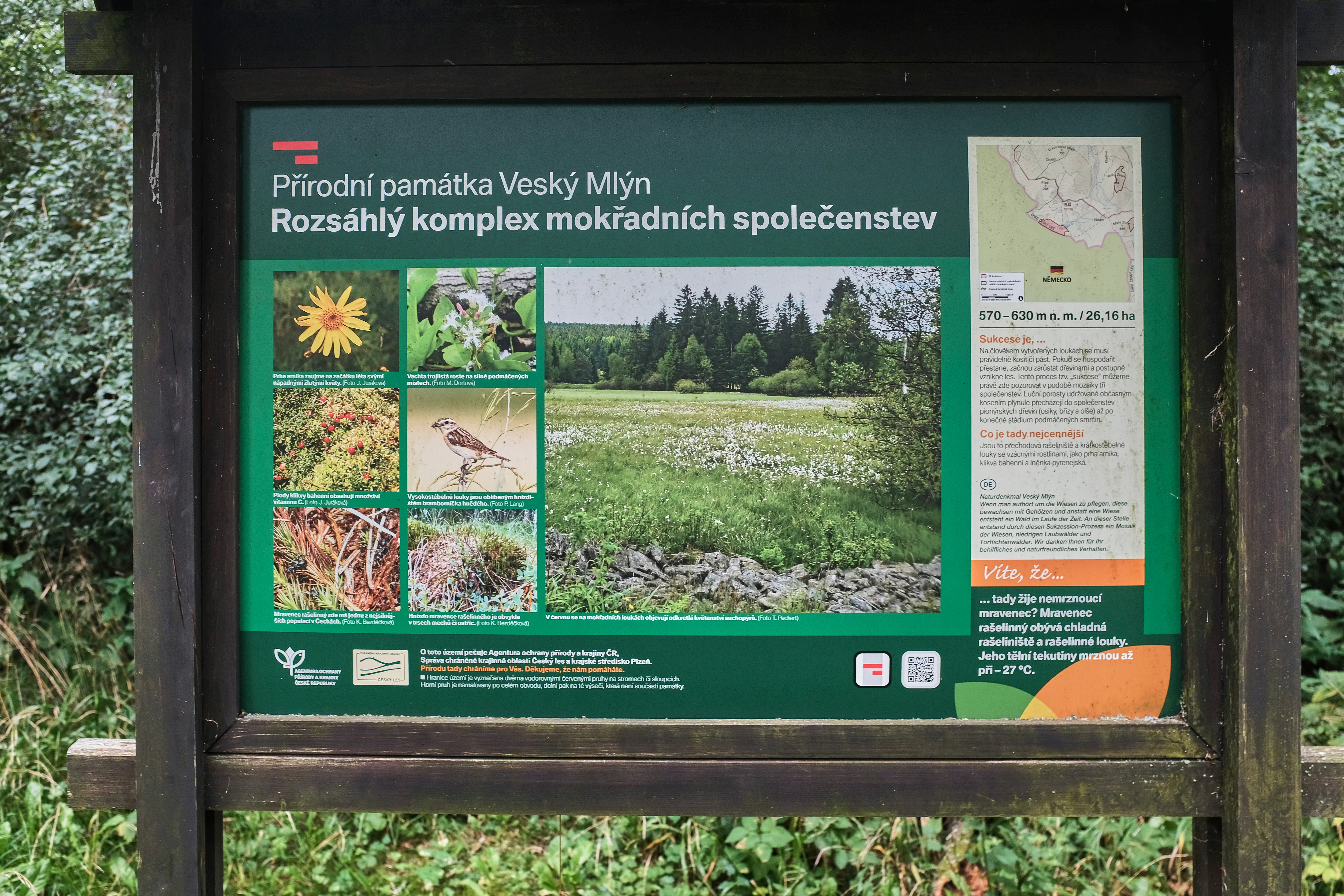
An information panel for the natural monument Veský mlýn located on a wooden frame, featuring a map, text, and several small photographs of local flora and fauna.
Information panel describing the natural monument Veský mlýn.

Veský mlýn history and protected-area timeline

The history of Veský mlýn is closely tied to the geopolitical shifts of twentieth-century Central Europe. The protected site takes its name from a former mill, the Veský mlýn, which once stood in the immediate vicinity of the present-day reserve near the German border. Before the Second World War, the surrounding landscape was inhabited predominantly by ethnic German communities, part of the broader Sudetenland region.

After the Second World War, the expulsion of the German population transformed the demographic character of the area, and many settlements were gradually abandoned. The Veský mlýn mill itself was abandoned and fell into ruin, leaving only its name as a local landmark. Beginning in 1948, the proximity to the Czechoslovak–German border made the area increasingly inaccessible to the civilian public. In 1950, with the formal establishment of the restricted border zone and later the fully prohibited zone, the entire population of the remaining villages was displaced.

The site remained part of the heavily guarded Iron Curtain border strip from the 1950s through the late 1980s. In the nearby village of Pleš, which in 1930 had more than a hundred houses and nearly five hundred inhabitants, a border guard unit was installed in 1951. The combination of depopulation and restricted access effectively removed the usual pressures of agriculture, forestry, and development from the land, which allowed the peatland and meadow habitats to persist without active management for several decades.

Following the political changes of 1989, the area gradually became accessible again. The present-day nature monument was designated on 1 July 2002 by the Domažlice District Office, formalizing the recognition of the site's ecological significance. The Czech Agency for Nature Conservation and Landscape Protection now manages the area as part of the Český les Protected Landscape Area, with a focus on preserving the open peatland character and restoring traditional hydrological conditions where possible.

Veský mlýn landscape and geographic character

The landscape of Veský mlýn is characteristic of the low-mountain foothills of the western Bohemian Forest. The terrain consists of gently undulating slopes and shallow valleys at elevations between seven hundred and seven hundred twenty meters above sea level, with no dramatic mountain summits but a continuous sequence of ridges and wet depressions. Geomorphologically the site belongs to the Český les geomorphological unit and the Čerchovský les sub-unit, where ancient crystalline rocks of the Moldanubicum shape the underlying structure.

The bedrock is dominated by cordierite gneiss, which produces slightly acidic, nutrient-poor soils. Combined with the relatively cool, moist climate, these conditions favor the development of peat-forming wetlands rather than richer forest soils. The result is a landscape in which open mires, rushes, and short-grass wet meadows alternate with surrounding spruce-dominated forest and small clearings. The transitions between bog, meadow, and forest are often gradual, creating the mosaic structure that defines the reserve.

Water is a defining element of the scenery. The Plešský potok flows through the site, fed by springs and small seepage areas along its course. In the broader catchment there are traces of old water-management features from the lost mills, including partial mill races and balancing reservoirs that once regulated water levels for industrial use. Although these structures no longer function, they remain as subtle reminders of the landscape's former human use and they still influence local hydrology.

Annual precipitation in the area is relatively high for the Czech context, reaching roughly eight hundred to nine hundred millimeters per year. This rainfall, retained in the peaty soils and slow-moving stream, sustains the wet conditions even during drier summer periods and gives the reserve its characteristic open, watery appearance.

Veský mlýn ecosystems, habitats, and plant life

Veský mlýn lies at the ecological interface between upland peatland and managed meadow. The vegetation is dominated by transitional peatland communities and short-grass wet meadows, which together form one of the rarer habitat types in the Bohemian Forest foothills. The peat-forming process is generally weak compared with classic raised bogs, but the combination of seepage, spring water, and acidic bedrock allows Sphagnum mosses, sedges, and specialized flowering plants to co-exist with more typical meadow species.

A particularly valuable component of the flora is the assemblage of protected and rare plant species that depend on this open habitat. These include the critically endangered crested shield fern (Dryopteris cristata), the strongly endangered marsh lousewort (Pedicularis sylvatica), the endangered small cranberry (Oxycoccus palustris) as a stable population, and several orchids and willows typical of nutrient-poor wetlands such as bogbean (Menyanthes trifoliata), May marsh orchid (Dactylorhiza majalis), and creeping willow (Salix repens). Arnica (Arnica montana) also occurs in scattered localities, reflecting the meadow element of the vegetation.

The animal life is closely tied to the same habitat mosaic. Open, sun-exposed peatland edges and meadows provide basking and hunting habitat for reptiles such as the common European adder, while wet, vegetation-rich ground supports breeding snipe and other wetland birds. The combination of old trees, water, and undisturbed ground offers roosting and foraging conditions for bats, including the long-eared bat (Plecotus auritus). Ravens and whinchats are also part of the breeding bird community, taking advantage of the open structure of the landscape.

Although the reserve is small, the concentration of specialized species is unusually high for an area of this size, which is why it has been given formal protection at the national level.

Veský mlýn wildlife and species highlights

The wildlife of Veský mlýn reflects the open and partially waterlogged character of the reserve. The common European adder (Vipera berus) is one of the most characteristic inhabitants, occurring here in a stable and abundant population despite being classified as critically endangered in the Czech Republic. The mix of sunny bog edges, tussock vegetation, and adjacent forest creates ideal basking and hunting conditions for the species.

The reserve is also significant for birdlife, especially for ground-nesting wetland and meadow species. The common snipe (Gallinago gallinago), classified as strongly endangered, breeds in the wetter parts of the peatland and along the Plešský potok. The whinchat (Saxicola rubetra) and the common raven (Corvus corax) also appear regularly, the former using open meadow edges and the latter nesting in the surrounding forest fringe. Together with other typical birds of the Bohemian Forest foothills, they contribute to a distinct and relatively species-rich bird community for such a small area.

Among mammals, the long-eared bat (Plecotus auritus), a strongly endangered species, is notable for its presence in the reserve. The combination of standing water, open space for foraging, and older trees near the reserve boundary provides suitable hunting and roosting habitat. Smaller mammals, amphibians, and invertebrates connected with peatland and wet meadow habitats are also part of the local fauna, although they are less specifically documented in publicly available sources.

The conservation value of the wildlife here is closely linked to the absence of intensive human activity over recent decades. Open habitats that would elsewhere be lost to drainage, fertilization, or afforestation have remained largely intact, allowing species that are increasingly rare in the wider Czech landscape to persist here.

Veský mlýn conservation status and protection priorities

Veský mlýn is a conservation unit of unusually focused character. It was established to protect a small but ecologically rich area of transitional peatland and short-grass meadow, two habitat types that have declined sharply across Central Europe over the past century. By formally designating the site as a nature monument, the Czech authorities aimed to safeguard rare plant and animal species that depend on this open, wet, and nutrient-poor environment.

The site is administered within the larger Český les Protected Landscape Area, which provides a higher-level framework for landscape-scale conservation. This nested arrangement allows Veský mlýn to benefit from broader regional planning while retaining its own strict species- and habitat-focused protection regime. Management is handled by the Czech Agency for Nature Conservation and Landscape Protection, which coordinates activities such as monitoring, hydrological maintenance, and, where necessary, control of invasive species.

The conservation relevance of the site is amplified by its border-zone history. Because the area was effectively sealed off during the Communist period, it escaped many of the destructive changes that affected similar habitats elsewhere in Bohemia: drainage of wet meadows, conversion to fertilized grassland, afforestation, or peat extraction. The open character and hydrological conditions observed today are therefore largely a consequence of this passive protection, and current management focuses on maintaining and gently restoring those conditions.

At the international level, the site is classified within the IUCN framework as a Category IV protected area, indicating a focus on the conservation of specific species or habitats through active management. This classification underlines the role of Veský mlýn as a complement to larger wilderness-oriented reserves nearby and as a refuge for biodiversity in one of the most species-rich low-mountain regions of the western Czech Republic.

Veský mlýn cultural meaning and human context

The cultural context of Veský mlýn is shaped by the layered history of the Czech-German borderland. The site lies in an area that was, until the mid-twentieth century, a living landscape of small villages, mills, and mixed agricultural land, with a predominantly German-speaking population. The local economy was based on forestry, livestock, and small-scale water-powered industry, including the mills whose names are still preserved in the landscape, such as the Veský mlýn itself.

The expulsion of the German population after 1945 and the subsequent creation of the restricted border zone erased much of this social fabric. Whole communities, including the village of Pleš with its former hundred-plus houses, depopulated within a few years, and the everyday rhythms of land use vanished with them. Today, the cultural imprint of that history is largely archaeological or toponymic: place names, ruined foundations, and old water-management structures visible in the reserve.

Since 1989, the border has gradually opened, and cross-border links have been slowly re-established. The nearby border crossing of Pleš/Fridrichshäng allows visitors to reach the edge of the reserve from the German side. This reconnection has created new opportunities for joint conservation work and cross-border ecological management, reviving in a different form the long-standing cultural connections between communities on either side of the Bohemian Forest ridge.

Top sights and standout views in Veský mlýn

Veský mlýn is a compact but ecologically rich reserve whose main highlights lie in the combination of rare peatland flora, specialized fauna, and a preserved post-Iron Curtain landscape. Among its most notable features are the stable population of the endangered small cranberry, the presence of the critically endangered crested shield fern, and one of the few robust populations of the common European adder in the region. The bog-meadow mosaic and the headwater Plešský potok also give the site its distinct scenic character.

Best time to visit Veský mlýn

The reserve itself is generally accessible only at its edges, and its character changes relatively little through the year. Late spring and early summer are the most rewarding periods for visitors interested in the flora, when the orchids, marsh lousewort, and other flowering plants of the wet meadows are at their peak. Early morning and evening during warmer months also offer the best chance to observe reptile and bat activity.

In autumn, the surrounding forests of the Český les add color to the broader landscape, while the peatland itself takes on a more subdued, waterlogged appearance. Winter visits are feasible for those interested in the broader scenery of the Bohemian Forest, though access to the reserve's interior remains restricted in all seasons, consistent with its protected status.


Monthly climate preview

Long-term representative measurements and monthly weather patterns

Veský mlýn Climate Normals, Annual Temperature and Precipitation Rhythm

Historical records from 1991 to 2020 document the measured annual temperature and precipitation rhythm across Veský mlýn at a representative elevation of 503.79 meters. Examining the complete twelve-month climatology dataset reveals detailed variations in average minimum and maximum temperatures for each month.
Annual mean8 °C
-3 °C19 °C
Jan-3°
Feb-2°
Mar
Apr
May13°
Jun16°
Jul19°
Aug19°
Sep14°
Oct
Nov
Dec-1°
Warmest month
July

18.7 °C

Coolest month
January

-2.6 °C

Wettest month
June

2.7 mm/day

Driest month
April

1.3 mm/day

Park location guide

Geography guide, regional context, and park location map for Veský mlýn

Veský mlýn park geography, regions, and map view in Czechia

Understand where Veský mlýn sits in Czechia through a broader geographic reading of the surrounding landscape, nearby location context, and its mapped position within the national park landscape.

How Veský mlýn fits into Czechia

Czech Republic is a landlocked Central European country with a population of approximately 10.9 million people. The nation was established as an independent state on January 1, 1993, following the dissolution of Czechoslovakia. Its capital and largest city is Prague, with other major urban centers including Brno, Ostrava, Plzeň, and Liberec.

Wider geography shaping Veský mlýn in Czechia

The Czech Republic is a landlocked country in Central Europe. It is bordered by Germany to the west, Austria to the south, Poland to the northeast, and Slovakia to the southeast. The landscape is predominantly hilly, with the territory covering 78,871 square kilometers.

Map view of Veský mlýn

Use this park location map to pinpoint Veský mlýn in Czechia, understand its exact geographic position, and read its mapped placement within the surrounding landscape more clearly.

Pigeon | © OpenStreetMap contributors

Location context for Veský mlýn

Domažlice DistrictPlzeňský kraj

Explore detailed imagery of transitional peatlands, wet meadow habitats, and regional terrain character.

Veský mlýn Photos and Landscape Scenery: Visualizing Western Bohemia Protected Areas

Visual documentation reveals the distinctive topography, spring-fed stream networks, and delicate botanical communities defining Veský mlýn. Photographic records provide clear insight into the protected landscape features and open habitat structure preserved within the Bohemian Forest foothills.

An information panel for the natural monument Veský mlýn located on a wooden frame, featuring a map, text, and several small photographs of local flora and fauna.

A narrow, grassy dirt path runs through a field of dry grass, bordered on the right by a dense conifer forest and on the left by open meadows.

Park atlas

Compare nearby transitional peatlands and connected protected landscapes across western Bohemia

Other Parks Near Veský Mlýn and Protected Areas in the Surrounding Bohemian Forest Region

Browse other protected areas and nature reserves located close to Veský mlýn in the Bohemian Forest foothills. Continuing into regional park exploration reveals broader ecological patterns across similar low mountain wetland habitats.
Protected landscapeBavaria
About 1.1 km away#1 closest

Northwest

Naturpark Nördlicher Oberpfälzer Wald: Protected Landscape and Regional Geography Map

Forested upland terrain and volcanic geology in Bavaria

Explore the structured geography of Naturpark Nördlicher Oberpfälzer Wald, a massive protected region in Bavaria. This detailed profile highlights the park's characteristic ridge and valley terrain, volcanic basalt landmarks, and its role as a vital ecological belt along the international border.

Area
1,380 km²
Water
Minor water
A soft, pastel watercolor painting of a serene pond landscape with gentle green hills, grassy banks, and a light pink and yellow sky.
Nature reservePlzeňský kraj
About 19 km away#2 closest

Southeast

Postřekovské rybníky Nature Reserve: A Detailed Geographic Atlas of Bohemian Wetlands

Protected fishpond landscapes and wetland geography in Plzeňský kraj.

Postřekovské rybníky is a protected nature reserve situated between Postřekov and Klenčí pod Čerchovem. The landscape features over twenty traditionally managed fishponds embedded in a mosaic of damp meadows and stream floodplains. This compact area functions as a significant migratory site and breeding ground, representing a vital remnant of traditional Bohemian land management and specialized wetland ecology.

Area
0.965 km²
Established
1990
IUCN
IV
Relief
Lowland
Protected landscapeBavaria
About 21 km away#3 closest

Southwest

Naturpark Oberpfälzer Wald: Geographic Atlas and Protected Landscape Overview in Bavaria

Examining the terrain, forest ridges, and regional drainage patterns.

Naturpark Oberpfälzer Wald serves as a prominent protected landscape in Bavaria, Germany. This area encompasses a complex of Scots pine and Norway spruce forests, rugged rock outcrops, and the historic Charlottenhofer Weihergebiet. The region connects seamlessly to broader European mountain belts, offering a unique opportunity to study the intersection of traditional land use and natural conservation within the Oberpfalz administrative district.

Area
823 km²
Established
1994
Relief
Mountain
Climate
Temperate
A soft watercolor illustration depicting a panoramic mountain landscape with evergreen trees in the foreground and rolling hills in the background in pastel shades of green, yellow, and pink.
Protected landscapeBavaria
About 33 km away#4 closest

South

Naturpark Oberer Bayerischer Wald: Protected Landscape Geography and Map

Mountain summits, river wetlands, and quartzite ridges in Bavaria

Spanning over 1,700 square kilometers, Naturpark Oberer Bayerischer Wald stands as a major protected area in Bavaria. This territory features a complex interplay of high-altitude forest, glacial lake basins, and unique geological landmarks including the 150-kilometer Pfahl ridge. Discover how these diverse landscapes, ranging from alpine terrain to river floodplains, are mapped and preserved within this significant regional protected zone.

Area
1,733 km²
Established
1989
Relief
Mountain
Climate
Temperate
Natural monumentKarlovarský kraj
About 47 km away#5 closest

North

Milhostovské mofety: Geological Atlas of Natural Monuments in Karlovarský kraj

Cold mofette gas vents and wetland floodplain habitat.

Milhostovské mofety is a specialized natural monument protecting a cluster of carbon dioxide mofettes in the Cheb District. This site offers insight into regional post-volcanic phenomena, featuring shallow craters, alder carr landscapes, and amphibolite bedrock structures that illustrate the unique geological character of the Slavkov Forest territory.

Area
0.002 km²
Established
1993
IUCN
III
Relief
Lowland
A soft, impressionistic watercolor painting depicting a wide, marshy landscape with green fields, low hills in the distance, and a small meandering stream.
Nature reserveKarlovarský kraj
About 52 km away#6 closest

North

Prameniště Teplé Nature Reserve: Protected Wetland and River Source Geography

A diverse springhead sanctuary in Karlovarský kraj

Prameniště Teplé stands as a significant nature reserve protecting the essential wetland mosaic surrounding the source of the Teplá River. Featuring a delicate balance of bogs, meadows, and forest fringes, this protected area preserves the ecological character of western Bohemian water-dominated landscapes through its unique spring-fed geography.

Area
0.429 km²
Established
1993
IUCN
IV
Relief
Upland
A watercolor illustration showing rolling green hills, small clusters of trees, and a distant forested ridgeline against a soft sky.
Protected landscapeBavaria
About 57 km away#7 closest

West

Naturpark Hirschwald: A Protected Landscape and Geographic Overview in Bavaria, Germany

Calcareous dry grassland habitats and regional forest mosaic

Naturpark Hirschwald is a compact, mosaic-like protected landscape located in Bavaria. The park integrates the Lauterach valley, sun-exposed limestone slopes, and juniper-rich heathlands. Recognized for its critical role in bat conservation and diverse regional terrain, it provides a clear example of the ecological transition between the Franconian Alb and northern Upper Palatinate forests.

Area
277.6 km²
Established
2006
Relief
Upland
Climate
Temperate
A soft, light watercolor illustration of a rocky outcrop surrounded by evergreen trees against a hazy, distant mountainous background.
Natural monumentPlzeňský kraj
About 58 km away#8 closest

Northeast

Malesická skála Natural Monument and Geological Heritage in Plzeňský kraj

Protecting rare sedimentary rock formations and oak-pine forest habitats

Malesická skála serves as a significant geological reserve, protecting a unique elliptical rock pillar that reveals the history of Carboniferous stream currents. Visitors can study the complex surface textures formed by iron-bearing cementation, including dramatic rock caps and weathered ledge systems. The surrounding woodland, characterized by an oak-pine bilberry forest, provides an essential natural context for this rare Bohemian landmark.

Established
1974
IUCN
III
Relief
Upland
Climate
Temperate

Common questions about visiting, size, designation, and location context for Veský mlýn

Veský mlýn FAQs for park facts, access, geography, and protected area context

Find quick answers about Veský mlýn, including protected-area facts, park geography, trail and visitor context, and how the park fits into its surrounding country and regional landscape.
MoriAtlas Explorer

Continue Your Protected Areas Search Across the Global Atlas

Deepen your exploration by continuing the structured search for national parks and protected areas worldwide. Utilize the comprehensive filtering capabilities to compare different conservation landscapes and refine your understanding of global park geography. Discover more about the distribution and characteristics of protected natural areas.

Global natural geography