
Why Villingen Süd stands out
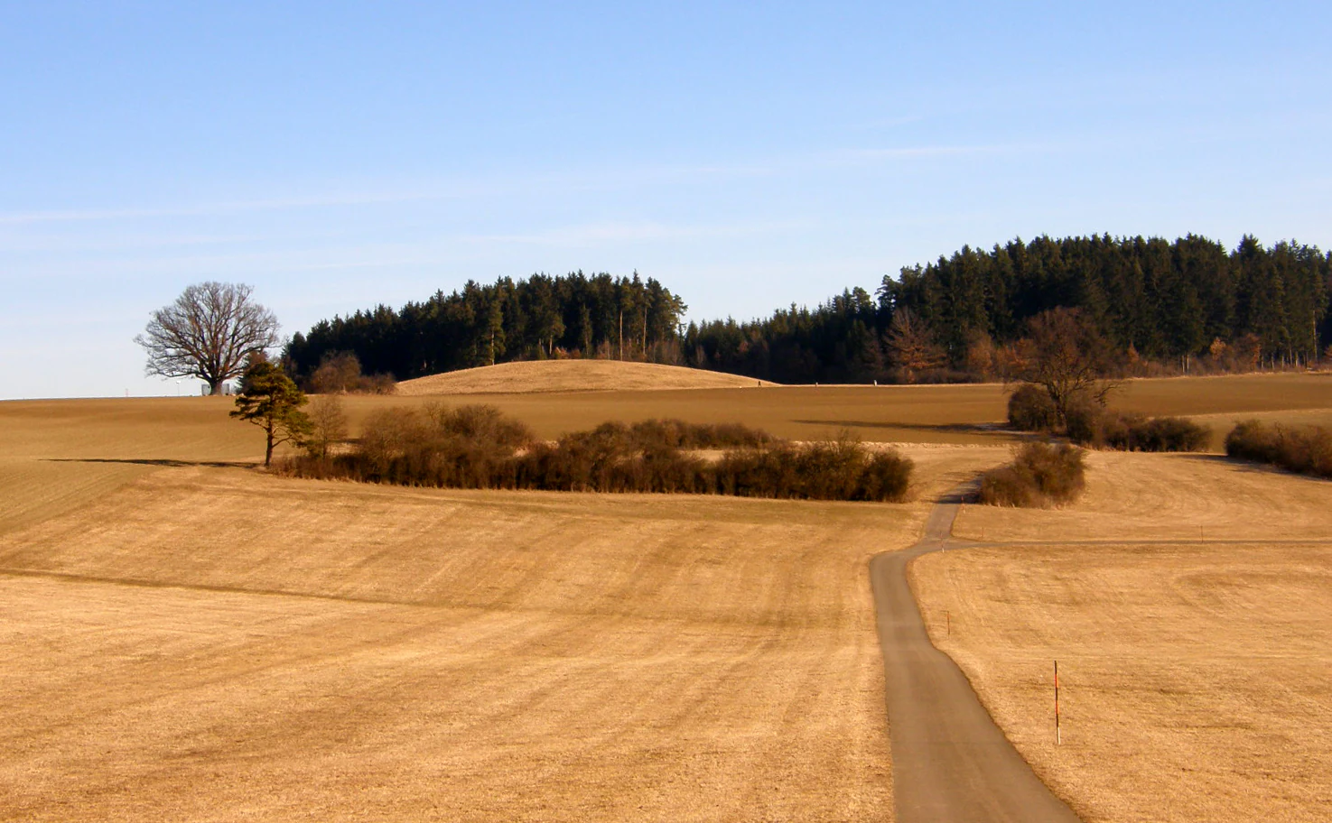
Villingen Süd is best known as a richly structured agricultural landscape at the foot of the Magdalenenberg, the prominent Iron Age burial mound that dominates the center of the protected area. It represents a typical Baar plateau mosaic of meadows, hedgerows, field copses, small water bodies, and scattered woodland, preserved within the expanding urban fringe of Villingen-Schwenningen.
Villingen Süd history and protected-area timeline
The protected landscape Villingen Süd was formally established on 16 April 1991 through an ordinance issued by the Landratsamt Schwarzwald-Baar-Kreis. Its designation came as part of a wider wave of landscape protection efforts in Baden-Württemberg during that period, aiming to preserve representative rural landscapes in the face of expanding urban development around growing towns such as Villingen-Schwenningen.
The landscape itself, however, is much older than its protected status. The area has been shaped by long-term agricultural use, with the hedges, field copses, meadows, and small woodland patches reflecting generations of farming practice on the Baar plateau. Most strikingly, the Magdalenenberg burial mound at the center of the area testifies to human activity in the region going back to the Iron Age, making the landscape a place where prehistoric and modern land use coexist within a single protected framework.
In the decades since its 1991 designation, Villingen Süd has been progressively integrated into larger European conservation frameworks through its overlap with the Baar Bird Protection Area and parts of the FFH area Baar, Eschach und Südostschwarzwald, placing it within the Natura 2000 network while remaining administered as a regional landscape protection area.
Villingen Süd landscape and geographic character
The setting of Villingen Süd reflects the gentle, rolling character of the Baar plateau. Unlike the deeply incised valleys of the inner Black Forest, this transitional landscape has a more open, agricultural feel, with broad areas of arable land, meadows, and pasture stitched together by hedgerows and small stands of trees.
At the heart of the area rises the Magdalenenberg, a prominent Iron Age burial mound that visually and culturally anchors the landscape. Around it, the terrain is dissected by small watercourses such as the Warenbach, which flows on toward the Brigach, one of the headwater streams of the Danube, and the smaller Lohwaldgraben. Between Rietheim and Marbach, a number of small artificial ponds add reflective surfaces and wetland edges to the otherwise terrestrial mosaic.
The overall impression is of a richly structured cultural landscape: not a wilderness, but a working countryside whose ecological value lies precisely in its diversity of small features, its hedgerow networks, woodland patches, and water elements, all set against the backdrop of the Schwarzwald-Baar-Kreis landscape on the edge of Villingen-Schwenningen.
Villingen Süd ecosystems, habitats, and plant life
Ecologically, Villingen Süd represents the kind of semi-open agricultural landscape that has become increasingly rare across much of western Europe. The hedges and field copses running through the area create ecological corridors across otherwise open farmland, offering shelter, nesting sites, and movement routes for birds, small mammals, and insects. Small woodland patches add structural variation and contribute to local biodiversity, while the meadows preserve habitat for grassland species.
Water features also play an important role in the area's ecology. In addition to the Warenbach and Lohwaldgraben, the ponds between Rietheim and Marbach provide wetland microhabitats and are likely to support amphibian and aquatic insect populations. These features, combined with the area's position within the Naturpark Südschwarzwald and its inclusion in the Baar Bird Protection Area, make the protected landscape a meaningful piece of the larger ecological network of the region.
The overlapping FFH area, Baar, Eschach und Südostschwarzwald, further underscores the conservation value of the habitats within and adjacent to Villingen Süd, placing the landscape within a transnational framework for the protection of European natural heritage.
Villingen Süd wildlife and species highlights
While wildlife is not the primary focus of the area's designation, the habitat mosaic of meadows, hedgerows, small woods, streams, and ponds supports a varied fauna typical of traditional Black Forest fringe and Baar plateau landscapes. The area's inclusion within the Baar Bird Protection Area reflects its particular importance for birdlife, especially for species associated with mixed agricultural landscapes, such as those that depend on hedges, field margins, and small water bodies.
The small ponds between Rietheim and Marbach, along with the Warenbach and Lohwaldgraben, provide habitat for amphibians and a range of aquatic invertebrates, while the hedgerow network offers breeding and foraging opportunities for typical farmland-associated bird species. Small mammals, bats, and pollinating insects are also likely to benefit from the structural diversity of the area, particularly where older hedgerows and small woodland patches are preserved.
Rather than being a wildlife spectacle, Villingen Süd is better understood as a quietly functioning landscape in which routine species interactions, nesting, and seasonal movements are supported across a network of modest but ecologically meaningful features.
Villingen Süd conservation status and protection priorities
The conservation significance of Villingen Süd rests less on a single flagship habitat and more on the preservation of a working, richly structured agricultural landscape at a time when such landscapes are under increasing pressure from urban expansion and intensification. By protecting the mosaic of meadows, fields, hedges, and small woodlands around the southern edge of Villingen-Schwenningen, the designation safeguards ecological functions that purely protected wilderness areas might not deliver.
The area's integration into the Natura 2000 network strengthens its conservation profile. Much of the protected landscape overlaps with the Baar Bird Protection Area, while parts extend into the FFH area Baar, Eschach und Südostschwarzwald. These overlapping designations connect Villingen Süd to broader European conservation goals for habitat protection, bird conservation, and ecological connectivity across the Baar plateau and into the surrounding Black Forest landscapes.
At the regional level, the continued administration by the Landratsamt Schwarzwald-Baar-Kreis and its inclusion in the Naturpark Südschwarzwald frame the area within a wider set of policies supporting sustainable land use, cultural landscape preservation, and biodiversity conservation in southwestern Germany.
Villingen Süd cultural meaning and human context
Villingen Süd has a layered cultural significance rooted in thousands of years of human presence on the Baar plateau. The most prominent cultural marker is the Magdalenenberg, an Iron Age burial mound that rises from the surrounding fields. Such mounds are characteristic of the prehistoric landscape of southwestern Germany, and the Magdalenenberg gives the protected area a tangible archaeological dimension, linking contemporary land use to much older traditions of settlement, ritual, and burial.
Beyond archaeology, the wider pattern of hedges, field copses, meadows, and small woods reflects generations of farming practice and rural life. The presence of several Kleingartenanlagen, or allotment gardens, in the northern part of the area points to strong modern ties between the local population and the landscape, with residents actively cultivating and enjoying this rural-fringe environment on the edge of a larger urban settlement.
Top sights and standout views in Villingen Süd
Villingen Süd stands out for combining an everyday working agricultural landscape with high heritage and conservation value. The Magdalenenberg burial mound is the area's most visually distinctive and historically resonant feature, set among meadows and fields that have been farmed for generations.
Its ponds and streams, especially between Rietheim and Marbach, add ecological variety and visual interest, while its hedges and field copses create a finely textured mosaic of habitats. The area's overlap with the Baar Bird Protection Area and parts of the FFH area Baar, Eschach und Südostschwarzwald gives it importance within the broader Natura 2000 network, complementing its role as a regional landscape protection area within the Naturpark Südschwarzwald.
Best time to visit Villingen Süd
Because Villingen Süd is a working agricultural landscape rather than a high-altitude or remote wilderness, it tends to be most atmospheric in the warmer months, when meadows are in bloom and hedgerows are in full leaf, and in early autumn, when harvested fields open up long views across the Baar plateau toward the Magdalenenberg. Cooler seasons still offer rewarding walking conditions, but bird and pond life are at their peak between spring and early summer, when the area's ecological diversity is most visible.