

Mori Atlas logo
National parkWasur National Park

Trace the mapped boundaries of this protected area within the South Papua regional context.

Wasur National Park: South Papua National Park Geography and Protected Landscape Atlas

(Taman Nasional Wasur)

Wasur National Park stands as a significant protected area within the expansive geography of South Papua, Indonesia. This national park offers a crucial point of discovery for understanding regional protected landscapes and their mapped boundaries. Explore its geographic context and unique place within South Papua's natural terrain, contributing to a structured atlas of conservation lands.

wetlandsavannaRamsar sitebird biodiversityPapuaendemic species

Wasur National Park

National park

Park overview

Structured park overview, official facts, and landscape profile for Wasur National Park

Wasur National Park park facts, protected area profile, and essential visitor context

Review the core facts for Wasur National Park, including designation, size, terrain, visitor scale, habitats, and operating context in one park-focused overview.

About Wasur National Park

Wasur National Park represents one of Indonesia's most significant protected wilderness areas, located in the sparsely populated southern region of the island of New Guinea. The park encompasses an extensive wetland system centered on the Rawa Biru Lake, which serves as the ecological heart of this vast protected area. Its remote location in South Papua has allowed the ecosystem to remain relatively undisturbed by human activity compared to other protected areas in Indonesia, preserving natural processes and wildlife populations that have been altered or lost elsewhere. The park forms part of a transboundary conservation landscape that includes the neighboring Tonda Wildlife Management Area in Papua New Guinea and, through a WWF-initiated Tri-National Wetlands Program, connects conservation efforts across to Australia's Kakadu National Park. This international cooperation reflects the park's ecological significance within the wider region, particularly as a coastal wetland system that supports migratory bird populations and maintains ecological processes across national boundaries.

Quick facts and research context for Wasur National Park

Wasur National Park occupies the Merauke Regency in South Papua, Indonesia, near the town of Merauke. The park spans roughly 4,138 square kilometers and was formally established as a national park in 1990, having previously functioned as a wildlife reserve since 1978. It was designated as a Ramsar Wetland of International Importance in 2006, recognizing its significance as a coastal and inland wetland ecosystem. The park shares a border with the Tonda Wildlife Management Area in Papua New Guinea and has been the focus of WWF conservation efforts since 1991.

Protection and recognition

Terrestrial boundary data, transboundary framework, and international Ramsar treaty details.

Wasur National Park Protection Status and Global Ramsar Designation

Researchers can evaluate the terrestrial framework of Wasur National Park through documented designation history and transboundary management agreements. Verifying official records like the global Ramsar site registry helps trace how international environmental treaties overlap with regional conservation landscapes.

International recognition

Protection details

Protection scope
Terrestrial
Designated year
2006
Transboundary protection
Yes
Park context

Deeper park guide and search-rich context for Wasur National Park

Wasur National Park history, landscape, wildlife, and travel context

Explore Wasur National Park through its history, landscape character, ecosystems, wildlife, conservation priorities, cultural context, and seasonal travel timing in a structured park guide built for atlas discovery and search intent.

Why Wasur National Park stands out

Wasur National Park is best known as the 'Serengeti of Papua' for its sweeping wetland savanna and prolific wildlife populations. The park's flagship feature is Rawa Biru Lake, a vast open wetland that attracts extraordinary concentrations of birds and other fauna. It is renowned for its exceptional bird diversity, with up to 358 recorded species including approximately 80 that are endemic to New Guinea. The park is particularly famous for its populations of birds of paradise, southern cassowary, and numerous waterbird species, as well as being home to both saltwater and New Guinea crocodiles.

Wasur National Park history and protected-area timeline

The Wasur area was first designated as a wildlife reserve in 1978, covering approximately 2,100 square kilometers. In 1990, the protected area was expanded to its current extent of 4,138 square kilometers and formally declared a national park. The year 2006 marked a significant milestone with the park's designation as a Ramsar Wetland of International Importance under the Ramsar Convention, recognizing its outstanding universal value as a coastal and inland wetland. Conservation organizations have played a substantial role in the park's development, with the World Wide Fund for Nature initiating a conservation and development project at Wasur in 1991. A Tri-National Wetlands Program was established in 1995, fostering collaborative management between Wasur National Park, the Tonda Wildlife Management Area in Papua New Guinea, and Kakadu National Park in Australia, culminating in a formal Memorandum of Understanding between the three government conservation agencies in 2002.

Wasur National Park landscape and geographic character

The physical landscape of Wasur National Park is dominated by vast wetland systems centered on Rawa Biru Lake, which forms a focal point for the park's ecological character. Approximately 70 percent of the total park area consists of open savanna, characterized by expansive grasslands that support large populations of grazing wildlife. The remaining landscape comprises a diverse mosaic of vegetation types including freshwater swamp forest, monsoon forest, coastal forest, bamboo forest, and extensive sago swamp forest. The dominant plant species include mangroves, Terminalia species, and various Melaleuca, creating distinct ecological zones throughout the park. The wetland landscape is intersected by numerous waterways and water bodies that create seasonal flooding patterns, supporting the diverse habitats that make this area so ecologically significant.

Wasur National Park ecosystems, habitats, and plant life

The ecological character of Wasur is defined by its complex wetland ecosystem that supports extraordinary biodiversity across multiple habitat types. The savanna grasslands represent the dominant vegetation, part of the broader Trans-Fly savanna and grasslands ecosystem that spans the southern region of New Guinea. The swamp forest communities, particularly the sago swamp forests, provide critical habitat for numerous species and function as important carbon stores. The park's position within the New Guinea biogeographic region contributes to its exceptional species richness, with the wetland habitats serving as ecological stepping stones for species movement between inland and coastal environments. The mixture of permanently flooded wetlands, seasonal grasslands, and forested areas creates a dynamic ecological system that supports both aquatic and terrestrial biodiversity.

Wasur National Park wildlife and species highlights

Wasur National Park supports an exceptional diversity of wildlife, with particularly outstanding bird populations that include approximately 358 species, of which around 80 are endemic to the island of New Guinea. The park provides critical habitat for all six species of birds of paradise found in Papua, including the greater bird-of-paradise, king bird-of-paradise, and red bird-of-paradise. Notable fauna includes the southern cassowary, blue crowned pigeon, Pesquet's parrot, and various waterbirds including the black-necked stork. The wetland habitats support populations of New Guinea crocodile and saltwater crocodile, while the grasslands are home to agile wallaby and other marsupials. The park contains several Red Listed species in viable populations, including the southern crowned pigeon, New Guinea harpy eagle, dusky pademelon, and the Fly River grassbird, a species endemic to the Fly River basin.

Wasur National Park conservation status and protection priorities

Wasur National Park holds significant conservation value both nationally and internationally, recognized through its Ramsar designation as a Wetland of International Importance. The park protects one of the least disturbed wetland ecosystems in Indonesia and serves as a critical refuge for numerous endemic species that are increasingly threatened elsewhere on New Guinea. Its transboundary conservation relationships with Papua New Guinea's Tonda Wildlife Management Area and Australia's Kakadu National Park create a network of protected wetlands that support migratory species and maintain ecological connectivity across national boundaries. The park's designation as a Ramsar site in 2006 reflects international recognition of its outstanding universal value as a coastal and inland wetland, while ongoing WWF conservation programs support management and protection efforts.

Wasur National Park cultural meaning and human context

Four indigenous peoples groups inhabit Wasur National Park, belonging to the Kanum, Marind, Marori Men-Gey, and Yei tribes. These communities number approximately 2,500 people distributed across 14 villages within and surrounding the park boundaries. The park name derives from the Marori language, in which 'Waisol' means garden, reflecting the historical relationship between these communities and the land. Local populations rely on the park's natural resources for their food and daily needs, consuming fish, sago, sweet potato, deer, bandicoot, and wallaby. Traditional cultural practices including festivals, pig feasts, dancing, weaving, and traditional cooking methods continue in some form, though many aspects of indigenous culture are experiencing pressures of change. The southern portion of the park contains ancient agricultural mounds of archaeological significance, and numerous sacred sites hold spiritual importance for the local communities.

Top sights and standout views in Wasur National Park

Wasur National Park stands out as one of Indonesia's most ecologically significant protected areas, offering visitors access to an untouched wetland wilderness that supports extraordinary concentrations of wildlife. The 'Serengeti of Papua' nickname captures the essence of this vast savanna landscape where wildlife viewing can rival Africa's famous reserves, particularly during the dry season when animals congregate around remaining water sources. The park's exceptional bird populations, including six species of birds of paradise and the remarkable southern cassowary, make it a destination of global significance for ornithologists and wildlife enthusiasts. The transboundary conservation network connecting Wasur to Papua New Guinea and Australia underscores its importance within the wider Oceania region.

Best time to visit Wasur National Park

The optimal time to visit Wasur National Park aligns with the dry season, typically from May to October, when water levels recede and wildlife becomes more concentrated around the remaining wetland areas. This period offers the best opportunities for wildlife observation, particularly for viewing large concentrations of waterbirds and mammals around Rawa Biru Lake. The wet season brings extensive flooding that can limit access to certain areas but also transforms the landscape into a dynamic water world. Visitors interested in bird-of-paradise viewing should note that these species can be observed throughout the year, though the dry season generally provides more reliable sightings. The park's remote location and limited infrastructure mean that visits should be planned well in advance, with the cooler dry season months generally considered more comfortable for travel.

Monthly climate preview

Long-term temperature and precipitation averages recorded at representative coordinates

Wasur National Park Climate Normals and Measured Monthly Weather Patterns

Wasur National Park experiences a measured annual temperature and precipitation rhythm spanning long-term averages from 24.68 to 28.5 degrees Celsius alongside distinct monthly rainfall variations. Examining the complete twelve-month climate profile provides deeper insight into historical meteorological patterns across the protected landscape.
Annual mean27 °C
25 °C29 °C
Jan27°
Feb27°
Mar27°
Apr27°
May26°
Jun25°
Jul25°
Aug25°
Sep26°
Oct27°
Nov29°
Dec28°
Warmest month
November

28.5 °C

Coolest month
July

24.7 °C

Wettest month
February

9.9 mm/day

Driest month
September

1 mm/day

Park location guide

Geography guide, regional context, and park location map for Wasur National Park

Wasur National Park park geography, regions, and map view in Indonesia

Understand where Wasur National Park sits in Indonesia through a broader geographic reading of the surrounding landscape, nearby location context, and its mapped position within the national park landscape.

How Wasur National Park fits into Indonesia

Indonesia is a vast archipelagic nation in Southeast Asia and Oceania, spanning over 17,000 islands between the Indian and Pacific Oceans. As the world's fourth-most populous country with 288 million people, it features extraordinary cultural and biological diversity, withJavanese and Sundanese being the largest ethnic groups. The country gained independence from the Netherlands in 1945 and operates as a unitary presidential republic.

Wider geography shaping Wasur National Park in Indonesia

Indonesia is situated in Southeast Asia and Oceania, spanning the equatorial region between the Indian Ocean to the west and the Pacific Ocean to the east. The archipelago includes major islands such as Sumatra, Java, Sulawesi, and parts of Borneo and New Guinea. It borders Papua New Guinea, Timor-Leste, and Malaysia by land, with extensive maritime boundaries throughout the region.

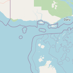
Map view of Wasur National Park

Use this park location map to pinpoint Wasur National Park in Indonesia, understand its exact geographic position, and read its mapped placement within the surrounding landscape more clearly.

Pigeon | © OpenStreetMap contributors

Location context for Wasur National Park

South Papua
Park atlas

Compare Wasur National Park's unique wetland savanna with other protected areas across the broader South Papua and New Guinea regions.

Explore National Parks and Protected Areas Near Wasur National Park, Indonesia

Browse a curated list of national parks and protected areas located near Wasur National Park, encompassing diverse wetland, savanna, and forest ecosystems within Indonesia's South Papua region. Deepen your geographic understanding by comparing their unique conservation landscapes, exploring contiguous natural habitats, and tracing the wider protected-area networks of the surrounding territory.
Wildlife reserveWestern Province
About 58 km away#1 closest

Southeast

Tonda Wildlife Management Area: Atlas of Protected Wetlands and Savanna Landscapes

Geographic overview of Papua New Guinea's largest wetland conservation zone

Spanning nearly 6,000 square kilometres of floodplain, Tonda Wildlife Management Area is defined by its exceptionally flat terrain and shifting mosaic of monsoon forest, tidal channels, and freshwater marshes. This protected landscape functions as an essential ecological bridge within the Trans-Fly ecoregion, maintaining deep connections to international conservation partners while preserving the integrity of its native bird and mammal habitats.

Area
5,900 km²
Established
1975
Protected areaQueensland
About 74 km away#2 closest

Southeast

Warul Kawa Indigenous Protected Area: A Geographic Profile of a Remote Torres Strait Sand Cay

Protecting northern Australian reef platforms and marine habitats

Warul Kawa Indigenous Protected Area, or Deliverance Island, defines a unique landscape of sand cays and shallow algal reef platforms in the far north of Queensland. As a key site for flatback turtle breeding and migratory green turtles, the area offers a rare example of a near-pristine marine environment. Its geography highlights the intersection of Indigenous land management and high-integrity tropical island ecosystems.

Established
2001
Relief
Lowland
Climate
Tropical
Access
Remote access
Marine protected areaQueensland
About 200 km away#3 closest

South

West Cape York Marine Park: Atlas and Geographic Context for Queensland Marine Reserves

Protected marine habitats in the Gulf of Carpentaria

Examine the extensive marine landscape of West Cape York Marine Park, a key component of the North Marine Parks Network. This protected area features deep basin waters and productive shelf margins that serve as a transition zone between the Gulf of Carpentaria and the Torres Strait, safeguarding high biodiversity levels.

Area
16,012 km²
Established
2018
IUCN
IV
Relief
Lowland
National parkAustralia
About 233 km away#4 closest

Southeast

Possession Island National Park: National Park Atlas and Mapped Geographic Context

Australia's protected natural terrain and park boundaries.

Possession Island National Park serves as a vital point of discovery for understanding Australia's protected lands. This national park provides detailed insights into its specific geographic setting and landscape character, contributing to a broader atlas of natural territories. Engage with its mapped boundaries and unique terrain to grasp its significance within the country's conservation landscape. It is an essential component for anyone exploring the geography of Australian national parks.

Marine protected areaQueensland
239 km away#5 closest

Southeast

Great Barrier Reef Marine Park: Atlas and Geographic Context for Queensland Protected Waters

Exploring the reef system and marine conservation zones in northeastern Australia

The Great Barrier Reef Marine Park stands as an internationally significant marine protected area. By spanning a massive stretch of the Queensland coast, this protected landscape provides a critical framework for marine governance and reef conservation. Users can examine the unique zoning and distribution of coral reef habitats that define this extensive tropical ecosystem.

Area
343,966 km²
Established
1975
Climate
Tropical
Scope
Marine
National parkQueensland
About 298 km away#6 closest

Southeast

Apudthama National Park: Queensland National Park Protected Landscape Geography

Explore the mapped boundaries and regional context.

Apudthama National Park offers a distinct national park experience within Queensland, Australia, focusing on its protected area identity and geographic landscape. This entry provides critical atlas-level information, detailing the park's mapped boundaries and its position within the regional geography. Understand the specific natural terrain and conservation context of this significant protected land.

Area
2,370 km²
Established
1994
IUCN
II
Relief
Lowland
National parkAustralia
About 310 km away#7 closest

Southeast

Yamarrinh Wachangan Islands (Denham Group) National Park: Australian Protected Landscape Map and Geography

Mapped boundaries and regional geographic context within Australia.

This detail entry for Yamarrinh Wachangan Islands (Denham Group) National Park provides specific geographic context and atlas information for this Australian national park. It focuses on the protected landscape identity, mapped features, and regional setting, offering a factual foundation for understanding the park's place within Australia's protected areas network. Explore its unique geographic characteristics and its designation as a national park.

Wildlife reserveSouthern Highlands Province
About 314 km away#8 closest

Northeast

Lake Kutubu Wildlife Reserve: Geographic Boundaries and Highland Ecosystem Mapping

Protected freshwater terrain in the Southern Highlands Province

Lake Kutubu represents an essential protected landscape in the Papua New Guinea highlands, serving as a critical upland basin for diverse freshwater species. This overview highlights the reserve's unique geographic setting, covering its expansive 19-kilometer stretch, surrounding montane forests, and its role within the Kikori River catchment. Access detailed landscape context and regional environmental data for this globally significant lacustrine ecosystem.

Area
51.84 km²
Relief
Mountain
Scope
Terrestrial
Water
Water-dominated

Common questions about visiting, size, designation, and location context for Wasur National Park

Wasur National Park FAQs for park facts, access, geography, and protected area context

Find quick answers about Wasur National Park, including protected-area facts, park geography, trail and visitor context, and how the park fits into its surrounding country and regional landscape.
MoriAtlas Explorer

Continue Your Protected Areas Search Across the Global Atlas

Deepen your exploration by continuing the structured search for national parks and protected areas worldwide. Utilize the comprehensive filtering capabilities to compare different conservation landscapes and refine your understanding of global park geography. Discover more about the distribution and characteristics of protected natural areas.

Global natural geography

