
Mori Atlas logo
Protected landscapeWdzydzki Park Krajobrazowy

Discover the intricate post-glacial lakeland geography, pine forest mosaic, and aquatic ecosystems of the Tuchola Forest region.

Wdzydzki Park Krajobrazowy: A Mapped Protected Landscape in Northern Poland's Pomeranian Voivodeship

Wdzydzki Park Krajobrazowy occupies a distinctive position in the Pomeranian Voivodeship, acting as a regional center for landscape conservation within the Tuchola Forest. This protected area centers on the archipelago-like Lake Wdzydze, featuring a complex network of glacial basins, interconnected smaller lakes, and peatlands. Its terrain is characterized by undulating sandy outwash plains and low moraine ridges, supporting vast coniferous woodlands and rare aquatic vegetation communities that define this unique post-glacial lakeland environment.

landscape parkPomeranian VoivodeshipKashubiaBory Tucholskiepost-glacial lakeslake archipelago
A flat-style illustration showing a sunlit mountain valley with a waterfall flowing into a winding river, surrounded by pine trees.

Wdzydzki Park Krajobrazowy

Protected landscape

Park overview

Structured park overview, official facts, and landscape profile for Wdzydzki Park Krajobrazowy

Wdzydzki Park Krajobrazowy park facts, protected area profile, and essential visitor context

Review the core facts for Wdzydzki Park Krajobrazowy, including designation, size, terrain, visitor scale, habitats, and operating context in one park-focused overview.

About Wdzydzki Park Krajobrazowy

Wdzydzki Park Krajobrazowy protects one of the most characteristic post-glacial lakeland landscapes in northern Poland. Its core is Lake Wdzydze, a large, multi-basin lake whose irregular shoreline, bays, and islands create a scenery that resembles an inland archipelago rather than a single body of water. Around this central lake system sit numerous smaller lakes, peatlands, and forested basins, all embedded within the broader landscape of the Bory Tucholskie.

The physical setting of the park reflects the legacy of Pleistocene glaciation. Glacial scour and outwash sediments produced the undulating terrain, sandy soils, and extensive mires that today shape the park's ecology. The lake basins, boggy hollows, and sandy uplands support a mosaic of habitats ranging from open water and floating vegetation mats to raised bogs, wet alder forests, dry pine forests, and small patches of more diverse deciduous woodland.

From a protection standpoint, the park is organized as a Polish park krajobrazowy, a landscape protection category that balances nature conservation with traditional land uses, recreation, and cultural continuity. The park's administrative seat and cultural surroundings lie within the historical region of Kashubia, and the area has long been associated with water-based recreation, fishing traditions, and the visual culture of Kashubian lake scenery. A system of nature reserves, planned reserves, and natural monuments further tightens the protection of the most sensitive lake, peatland, and forest sites.

For visitors and regional planners, the park functions as a major outdoor recreation hub. Long-distance hiking trails, including the Stone Circles Trail and the Kashubian Trail, cross the area, and water trails follow the Wda river and connecting lakes. Viewpoints and lakeshore landscapes offer the most accessible impressions of the park's identity, while the surrounding buffer zone helps maintain the ecological coherence of this large forested lakeland.

Quick facts and research context for Wdzydzki Park Krajobrazowy

Wdzydzki Park Krajobrazowy is a Polish landscape park (park krajobrazowy) located in the Pomeranian Voivodeship, overlapping the municipalities of Dziemiany, Karsin, Kościerzyna, Lipusz, and Stara Kiszewa.

The park lies within the Bory Tucholskie physical-geographical mesoregion, covers roughly 178 square kilometers with a surrounding buffer zone of about 152 square kilometers, and was established on 15 June 1983 by resolution of the Provincial National Council in Gdańsk.

Protection and recognition

Terrestrial protected area classification and documented management scope.

Wdzydzki Park Krajobrazowy Protection Status and Conservation Context

Wdzydzki Park Krajobrazowy maintains a documented terrestrial protection status with defined regional management boundaries. Official records detail the conservation scope and designation history for this protected landscape.

Protection details

Protection scope
Terrestrial
Transboundary protection
No
Buffer area
152.08 km²
Park context

Deeper park guide and search-rich context for Wdzydzki Park Krajobrazowy

Wdzydzki Park Krajobrazowy history, landscape, wildlife, and travel context

Explore Wdzydzki Park Krajobrazowy through its history, landscape character, ecosystems, wildlife, conservation priorities, cultural context, and seasonal travel timing in a structured park guide built for atlas discovery and search intent.

Why Wdzydzki Park Krajobrazowy stands out

Wdzydzki Park Krajobrazowy is best known for the large, archipelago-like Lake Wdzydze and its surrounding chain of smaller lakes, all encircled by the sandy pine forests of the Tuchola Forest. The combination of open water, islands, peat bogs, and pine-dominated forest communities creates a particularly distinctive post-glacial lakeland landscape, often associated with the traditional identity of Kashubia. The park is also recognized for its well-preserved aquatic and peatland flora, including fully developed water and bog vegetation communities, and for the dense network of nature reserves that protect fragments of lakes, bog islands, and rare forest stands within its boundaries.
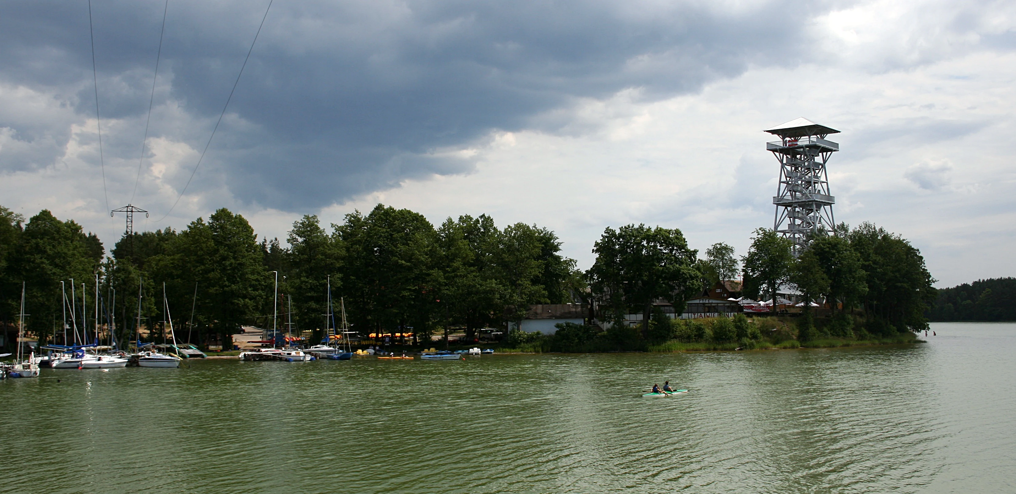
A metal observation tower rises above a tree line on the shore of a large lake, with several sailboats moored nearby under a cloudy sky.
A scenic lookout tower stands near the intersection of Lake Jelenie and Lake Golun in Wdzydzki Park Krajobrazowy.

Wdzydzki Park Krajobrazowy history and protected-area timeline

Wdzydzki Park Krajobrazowy was created on 15 June 1983 through a resolution of the Provincial National Council in Gdańsk (Uchwała nr XIX/83/83), during the period when Poland was developing its network of landscape parks to protect characteristic regional environments. Its establishment reflected growing recognition of the Bory Tucholskie as a nationally important forest and lake landscape that warranted a dedicated, large-scale protection framework centered on Lake Wdzydze.

Over the decades following its creation, the park's protection system was gradually strengthened through the designation of nature reserves, the documentation of natural monuments, and the planning of additional reserves around sensitive lakes, bogs, and forest stands. Mirror administrative changes, including the creation of the Pomeranian Voivodeship, placed the park within a new regional governance framework while maintaining its central role in the conservation of the Tuchola Forest landscape.

The park's history is also tied to the longer cultural genealogy of Kashubia, where Lake Wdzydze and its surroundings have long been a focal point of regional identity, summer recreation, and water-based livelihoods. Contemporary management continues to balance the preservation of this cultural-ecological landscape with its role as a recreational destination and ecological refuge.

Wdzydzki Park Krajobrazowy landscape and geographic character

The landscape of Wdzydzki Park Krajobrazowy is defined by the interplay between water and forest. Lake Wdzydze forms the park's centerpiece, a large and irregular body of water with deeply indented bays, peninsulas, and islands that visually fragment the lake into a series of interconnected basins. Smaller lakes such as Jelenie, Gołuń, and others create additional glacially carved water surfaces that punctuate the surrounding woodland.

The terrain is gently undulating, shaped by glacial processes that left sandy outwash plains, low moraine ridges, and numerous kettle hollows now occupied by bogs or lakes. Views from elevated points along these ridges or from dedicated lookout points provide broad panoramas across the combined landscape of water, bog, and pine forest. The sandy soils favor extensive tracts of dry coniferous woodland, while the wetter hollows host alder carrs, bog woodland, and open peatlands.

Rivers and water trails tie the lakescape together. The Wda river and its tributaries connect the lake basins, supporting both ecological processes and recreational water routes. The combination of glacial lakes, peatlands, sandy uplands, and pine-dominated forest creates a post-glacial lakeland scenery that visually distinguishes the park from both the coastal lowlands and the upland regions of northern Poland.

Wdzydzki Park Krajobrazowy ecosystems, habitats, and plant life

Ecologically, Wdzydzki Park Krajobrazowy represents a richly varied post-glacial ecosystem in which freshwater habitats, peatlands, and forest communities are tightly interwoven. The park's lake system supports a fully developed aquatic and peatland flora, with floating-leaved, submerged, and emergent vegetation communities occupying the bays, shallows, and peat-covered shorelines of Lake Wdzydze and the surrounding smaller lakes.

The forest cover of the park is dominated by dry coniferous communities, including fresh pine forest and lichen-rich pine forest typical of sandy Tuchola Forest soils. Boggy depressions carry bog pine communities on small but ecologically important surfaces, while richer sites support acid oak forests, alder-ash floodplain forests, alder swamps, and fragments of oak-lime-hornbeam woodland. This diversity of forest types reflects the underlying variability of soil moisture, nutrient status, and glacial landforms.

Peatlands are a particularly important ecological feature. Raised bogs, transitional mires, and lakeside peat formations create conditions for specialized plant communities and contribute to the park's role in carbon storage and hydrological regulation. The interaction between forests, wetlands, and open water supports a wide ecological gradient that sustains both common and more sensitive species across the protected landscape.

Wdzydzki Park Krajobrazowy wildlife and species highlights

The wildlife profile of Wdzydzki Park Krajobrazowy is shaped by its mosaic of lakes, peatlands, and forests. Aquatic habitats, including the open bays and quieter shorelines of Lake Wdzydze, support fish populations typical of large Pomeranian lakes as well as amphibians that rely on shallow, vegetated waters for breeding. The park's extensive bog and marsh complexes provide habitat for wetland-associated birdlife, including species linked to reedbeds, open peatland surfaces, and boggy lake margins.

The surrounding coniferous forests of the Tuchola Forest host a community of woodland birds typical of European pine-dominated landscapes, alongside mammals such as red deer, roe deer, and wild boar. Wet forest patches and mixed deciduous stands add further habitat complexity, supporting species that depend on structurally richer woodland. The interaction between undisturbed forest tracts, bogs, and lake shorelines gives the park a continuous ecological gradient that supports both resident and migratory wildlife.

Wdzydzki Park Krajobrazowy conservation status and protection priorities

Wdzydzki Park Krajobrazowy plays a significant role in the conservation of the Tuchola Forest region's freshwater, peatland, and forest heritage. As a park krajobrazowy, it provides a framework of landscape-level protection that integrates ecological preservation with controlled recreational use, helping to maintain large-scale ecological processes across the lake and forest complex.

The park's conservation significance is reinforced by a layered system of stricter reserves. A formally designated nature reserve, Krwawe Doły, and numerous proposed reserves target specific sensitive features: peatlands, bog islands, lake islands, lakeshore fragments, and rare forest stands such as the beech forest at Leśnictwo Głuchy Bór. Together with twenty-one natural monuments located within the park and its buffer zone, these reserves strengthen protection of elements that would otherwise be vulnerable within a working landscape.

In broader terms, the park contributes to the connectivity of protected natural areas across the Bory Tucholskie, preserving ecological corridors between lakes, mires, and forest tracts. Its protection of aquatic vegetation, peatland communities, and characteristic pine forest types makes it an important reference area for understanding and conserving the post-glacial lakeland landscapes of northern Poland.

Wdzydzki Park Krajobrazowy cultural meaning and human context

Wdzydzki Park Krajobrazowy is embedded in the cultural landscape of Kashubia, a region with a distinct language, traditions, and historical identity in northern Poland. The park's Kashubian name reflects this heritage, and Lake Wdzydze has long been a symbol of the Kashubian lake district, frequently depicted in regional culture, painting, and folklore.

The lake and its surroundings also carry a strong tradition of summer recreation, fishing, and waterborne transport that has shaped local communities for generations. Settlements around the park continue a regional culture linked to forestry, small-scale agriculture, and lake-based livelihoods. Kashubian heritage, combined with the area's natural beauty, gives the park an identity that is as much cultural as ecological.

Trail networks and visitor routes that pass through the park also reinforce its cultural role. Long-distance paths such as the Kashubian Trail link the protected area with broader regional identities, while local tourism persists around traditional lakeside villages, contributing to the continuity of Kashubian material and intangible heritage.

Top sights and standout views in Wdzydzki Park Krajobrazowy

The strongest highlights of Wdzydzki Park Krajobrazowy revolve around its post-glacial lakescape: the archipelago-like profile of Lake Wdzydze with its bays, islands, and lookout points, and the chain of smaller lakes such as Jelenie and Gołuń embedded within the Tuchola Forest. The combination of water surfaces, peatlands, and pine-dominated forest gives the park a unified and easily recognizable visual identity.

Equally distinctive is the ecological richness packed into a relatively compact area: fully developed aquatic and peatland vegetation, rare bog and lakeshore plant communities, and protected forest stands including an exceptional beech forest in Leśnictwo Głuchy Bór. The layered system of nature reserves, proposed reserves, and natural monuments underscores the park's function as a refuge for sensitive habitats within a working landscape.

For visitors, the highlights extend to long-distance trails and water routes that link the park to wider Kashubia, offering both landscape-scale scenic experiences and more focused encounters with lakeshore viewpoints, peat mires, and historical forest communities.

Best time to visit Wdzydzki Park Krajobrazowy

The character of Wdzydzki Park Krajobrazowy shifts meaningfully with the seasons. Late spring and early summer bring active aquatic vegetation, blooming bog margins, and full forest leaf cover, making water bodies and peatlands visually rich and biologically animated. This period is favorable for observing wetland flora and birdlife along the lake shores and quieter bays.

Summer is traditionally the most active period for water-based recreation on Lake Wdzydze and surrounding lakes, offering the park's broadest range of trail and water route experiences. Autumn transforms the mixed forest elements, especially the oak and beech stands, into warm displays of color that contrast with the persistent green of the coniferous forests and the still reflective lake surfaces.

Winter shifts the atmosphere significantly: frozen lakes, snow-dusted pine forests, and quieter trails create a more contemplative landscape. While some water routes become inaccessible in freezing conditions, the forest scenery and the subdued atmosphere of the bog and lake landscapes remain rewarding for visitors seeking a quieter perspective on the park.
Monthly climate preview

Long-term representative point measurements for temperature and monthly precipitation

Wdzydzki Park Krajobrazowy Climate Normals and Annual Temperature Rhythm

Representative coordinate records show average monthly temperatures ranging from sub-zero winter minimums to warm summer maximums alongside consistent daily precipitation rates. Examining the full twelve-month climatology profile reveals complete seasonal weather patterns across the protected landscape.
Annual mean8 °C
-3 °C19 °C
Jan-3°
Feb-2°
Mar
Apr
May12°
Jun16°
Jul19°
Aug18°
Sep14°
Oct
Nov
Dec-1°
Warmest month
July

18.5 °C

Coolest month
January

-2.9 °C

Wettest month
July

2.7 mm/day

Driest month
April

1.3 mm/day

Park location guide

Geography guide, regional context, and park location map for Wdzydzki Park Krajobrazowy

Wdzydzki Park Krajobrazowy park geography, regions, and map view in Poland

Understand where Wdzydzki Park Krajobrazowy sits in Poland through a broader geographic reading of the surrounding landscape, nearby location context, and its mapped position within the national park landscape.

How Wdzydzki Park Krajobrazowy fits into Poland

Poland, officially the Republic of Poland, is a Central European country spanning from the Baltic Sea in the north to the Carpathian Mountains in the south. It borders Germany, Czech Republic, Slovakia, Ukraine, Belarus, Lithuania, and Kaliningrad Oblast. The country has a temperate climate, diverse landscapes, and is known for its rich history, cultural heritage, and strong economic position within the EU.

Wider geography shaping Wdzydzki Park Krajobrazowy in Poland

Poland occupies 312,696 km2 in Central Europe, extending from the Baltic Sea coast in the north to the Sudetes and Carpathian Mountains in the south. It borders Germany to the west, Czech Republic and Slovakia to the south, Ukraine and Belarus to the east, and Lithuania and Kaliningrad Oblast to the northeast. The landscape includes lowland plains, uplands, and mountain ranges.

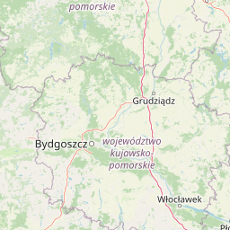
Map view of Wdzydzki Park Krajobrazowy

Use this park location map to pinpoint Wdzydzki Park Krajobrazowy in Poland, understand its exact geographic position, and read its mapped placement within the surrounding landscape more clearly.

Pigeon | © OpenStreetMap contributors

Location context for Wdzydzki Park Krajobrazowy

Pomeranian Voivodeship

Visual reference collection for post-glacial lakes, pine forests, and wetland habitats

Wdzydzki Park Krajobrazowy Landscape Photography and Protected Area Scenery

Visual records capture the distinctive post-glacial lakeland scenery of Lake Wdzydze and surrounding pine forests. Photographic documentation illustrates varied terrain features, aquatic habitats, and protected ecological communities across the region.

A metal observation tower rises above a tree line on the shore of a large lake, with several sailboats moored nearby under a cloudy sky.

Park atlas

Compare adjacent post glacial lakes and regional forest reserves in northern Poland

Other Parks Near Wdzydzki Park Krajobrazowy and Surrounding Protected Areas

Browsing nearby protected areas allows travelers to compare the post glacial lakes and pine forests of Wdzydzki Park Krajobrazowy with adjacent regional reserves. Evaluating surrounding conservation landscapes provides broader geographic context across the broader Kashubia terrain.
Protected landscapePomeranian Voivodeship
About 13 km away#1 closest

Southwest

Zaborski Park Krajobrazowy: Geographic Profile of a Polish Protected Landscape Area

Tuchola Forest region, Pomeranian Voivodeship

Investigate the unique terrain of Zaborski Park Krajobrazowy, a protected landscape defined by its dense network of glacial lakes and sandy outwash plains. This territory provides a comprehensive view of northern Polish lowland geography, highlighting the ecological significance of its river valleys and relic forest habitats within the broader Tuchola Forest ecosystem.

Area
340.3 km²
Established
1990
Relief
Lowland
Climate
Temperate
Nature reservePomeranian Voivodeship
About 15 km away#2 closest

East

Mechowisko Krag Nature Reserve: Mapping the Protected Peatlands of the Pomeranian Voivodeship

A specialized alkaline fen within the Bory Tucholskie forest region

Mechowisko Krag Nature Reserve serves as a key site for wetland conservation in Poland. This protected landscape preserves a rare alkaline peatland that sustains diverse moss communities and rare vascular flora, including bog Saxifrage, while providing shelter for wetland birds within the expansive Bory Tucholskie forest region.

Area
0.038 km²
Established
2016
Relief
Lowland
Scope
Terrestrial
Protected areaPomeranian Voivodeship
About 22 km away#3 closest

Southwest

Sandr Brdy: Protected Glacial Landscapes and Hydrological Networks in Pomeranian Voivodeship

A vital reference site for lowland habitat conservation and post-glacial terrain.

Sandr Brdy spans 7,492 hectares of outwash plains in northern Poland. Its terrain hosts a complex mosaic of calcareous fens, acid oak forests, and lobelia lakes, established to preserve fragile aquatic and terrestrial species like the gray wolf and lady's slipper orchid within a unique glacial framework.

Area
74.926 km²
Scope
Terrestrial
Water
Major water bodies
Nature reservePomeranian Voivodeship
About 23 km away#4 closest

Northwest

Studzienickie Torfowiska Nature Reserve: Geographic Atlas and Wetland Habitat Context

Protected peatland terrain in Pomeranian Voivodeship

Studzienickie Torfowiska represents a vital protected peatland system characterized by its mosaic of transitional mires, dystrophic lakes, and regenerating bog forests. The landscape focus lies on the interplay between saturated ground and peat accumulation, offering a clear regional perspective on wetland conservation within northern Poland's lowland geography.

Area
1.75 km²
Relief
Lowland
Climate
Temperate
Access
Access unknown
Watercolor painting of a soft, hazy wetland landscape with green foliage, pink marsh vegetation, and distant hills in pale tones.
Nature reservePomeranian Voivodeship
About 23 km away#5 closest

West

Rezerwat przyrody Dolina Kulawy: Mapping Peatlands and Wetlands in Pomeranian Voivodeship

A protected landscape featuring soligenous mires and glacial lakes.

Discover the intricate geography of Rezerwat przyrody Dolina Kulawy, a nature reserve centered on the Kulawa River valley in northern Poland. This protected area offers a unique look at soligenous peatlands, floodplain forests, and mesotrophic lake systems, providing essential context for the post-glacial landscape of the Bory Tucholskie region.

Area
1.546 km²
Established
2009
Relief
Lowland
Climate
Temperate
Nature reservePomeranian Voivodeship
About 25 km away#6 closest

North

Rezerwat przyrody Mechowiska Sulęczyńskie: Geography and Protected Area Landscape Analysis

Alkaline fen and peatland habitat in Pomeranian Voivodeship

Study the geographic distribution and protected status of Rezerwat przyrody Mechowiska Sulęczyńskie, an essential alkaline fen ecosystem in northern Poland. This reserve highlights the role of groundwater-fed landscapes in maintaining orchid populations and bryophyte-rich mires within a post-glacial region. The site serves as a reference point for peatland conservation and structural landscape integrity.

Area
0.252 km²
Established
2014
Relief
Lowland
Climate
Temperate
Biosphere reserveKuyavian-Pomeranian Voivodeship
About 25 km away#7 closest

South

Rezerwat Biosfery Bory Tucholskie: Protected Forest and Regional Landscape Map

Key protected zones in the Kuyavian-Pomeranian Voivodeship

Rezerwat Biosfery Bory Tucholskie encompasses the largest continuous forest complex in Poland, structured into a formal UNESCO framework. The terrain features postglacial outwash plains, chain lakes, and rare yew reserves that create a distinct ecological mosaic. This overview details the park's geographic layout, surrounding landscape parks, and the connection between its core nature reserves and the wider regional basin.

Area
3,195 km²
Established
2010
Relief
Lowland
Climate
Temperate
Protected landscapeKuyavian-Pomeranian Voivodeship
About 25 km away#8 closest

South

Tuchola Landscape Park: Mapped Protected Area and Riverine Geography in Poland

Pine-covered outwash plains and the meandering Brda River corridor

Covering a significant portion of northern Poland, Tuchola Landscape Park protects a distinctive postglacial landscape of sandy plains and dense pine forests. The park geography is anchored by the Brda River, which flows through a series of rapids and breakthroughs before reaching deep into the surrounding pine-clad outwash plain. Detailed map data provides insight into the park's eight nature reserves, which preserve critical wetland, bog, and riverine habitats.

Area
369.83 km²
Established
1985
Relief
Lowland
Climate
Temperate

Common questions about visiting, size, designation, and location context for Wdzydzki Park Krajobrazowy

Wdzydzki Park Krajobrazowy FAQs for park facts, access, geography, and protected area context

Find quick answers about Wdzydzki Park Krajobrazowy, including protected-area facts, park geography, trail and visitor context, and how the park fits into its surrounding country and regional landscape.
MoriAtlas Explorer

Continue Your Protected Areas Search Across the Global Atlas

Deepen your exploration by continuing the structured search for national parks and protected areas worldwide. Utilize the comprehensive filtering capabilities to compare different conservation landscapes and refine your understanding of global park geography. Discover more about the distribution and characteristics of protected natural areas.

Global natural geography