

Mori Atlas logo
Nature reserveWee Jasper Nature Reserve

Examine the mapped boundaries, forest diversity, and ecological terrain of this vital New South Wales nature reserve.

Wee Jasper Nature Reserve: A Detailed Geographic Profile of Protected Southern Tablelands Woodlands

Wee Jasper Nature Reserve represents a critical conservation landscape within the Southern Tablelands of New South Wales. This protected area preserves four distinct forest ecosystems across varied slope aspects, ranging from riparian she-oak corridors to dry eucalyptus woodlands. The reserve serves as a significant reference point for botanical diversity in eastern Australia, shielding rare and threatened plant species within its compact, undulating hill terrain.

Southern Tablelandsnature reservestrict nature reservewoodlandeucalypt forestshe-oak

Wee Jasper Nature Reserve

Nature reserve

Park overview

Structured park overview, official facts, and landscape profile for Wee Jasper Nature Reserve

Wee Jasper Nature Reserve park facts, protected area profile, and essential visitor context

Review the core facts for Wee Jasper Nature Reserve, including designation, size, terrain, visitor scale, habitats, and operating context in one park-focused overview.

About Wee Jasper Nature Reserve

Wee Jasper Nature Reserve occupies a modest footprint in the Southern Tablelands of New South Wales, but its ecological character is unusually concentrated. The reserve lies near the western edge of the Southern Tablelands, close to the Goodradigbee River and the impounded waters of Burrinjuck Dam, a landscape shaped by rivers, valleys, and rounded hill country typical of inland south-eastern Australia.

The reserve was formally protected in 1979 and has been incrementally expanded over the following decades through land additions in 1986 and 2001. It is administered by the NSW National Parks and Wildlife Service and is classified as a strict nature reserve, the highest conservation tier in the New South Wales reserve system. This category prioritises the maintenance of native ecosystems and ecological processes, with minimal provision for intensive recreation or development.

Ecologically, the reserve is characterised by a mosaic of eucalyptus-dominated woodlands and grassy forests on the slopes, transitioning to a distinct she-oak dominated community along the creek lines. The variation in slope aspect, exposure, and soil creates sharply different vegetation communities across short distances, and this ecological diversity is one of the reserve's defining scientific values.

The reserve has grown in conservation importance due to the discovery and confirmation of several threatened plant species within its boundaries. It remains an active focus for botanical interest in the region, particularly for researchers and managers concerned with rare woodland species and their habitat requirements in the Southern Tablelands.

Quick facts and research context for Wee Jasper Nature Reserve

Wee Jasper Nature Reserve is a strict nature reserve located in the Southern Tablelands of New South Wales, near the village of Wee Jasper and the Goodradigbee arm of Burrinjuck Dam. Established in November 1979 and managed by the NSW National Parks and Wildlife Service, it is classified under the strictest IUCN-style reserve category in New South Wales, reflecting its dedicated conservation purpose.

The reserve is small but ecologically rich, covering several distinct forest ecosystems arranged across south-eastern, eastern, and western slopes, as well as along the creek system. Its significance lies particularly in its populations of threatened plants, including species listed as vulnerable or endangered under New South Wales threatened-species legislation.

Protection and recognition

Examine documented conservation scope and formal international recognition data

Wee Jasper Nature Reserve Protection Status and Territorial Designation

Wee Jasper Nature Reserve maintains a terrestrial protection framework encompassing documented management scopes and administrative boundaries. Formal recognition records supply essential baseline facts regarding the conservation status and territorial designation.

Protection details

Protection scope
Terrestrial
Transboundary protection
No
Park context

Deeper park guide and search-rich context for Wee Jasper Nature Reserve

Wee Jasper Nature Reserve history, landscape, wildlife, and travel context

Explore Wee Jasper Nature Reserve through its history, landscape character, ecosystems, wildlife, conservation priorities, cultural context, and seasonal travel timing in a structured park guide built for atlas discovery and search intent.

Why Wee Jasper Nature Reserve stands out

Wee Jasper Nature Reserve is best known for protecting a cluster of rare and threatened plant species within an otherwise compact landscape of Southern Tablelands forest. Several plants recorded here are considered uncommon or restricted in New South Wales, including a vulnerable daisy species and an endangered grevillea that has become closely associated with the Wee Jasper area. The reserve is also recognised for the diversity of forest ecosystems packed into a relatively small area. Within just a few hundred hectares, four distinct plant communities occur on different slopes and along the creek corridor, making the reserve a useful reference point for understanding how aspect, soil, and drainage shape woodland communities in this part of eastern Australia.
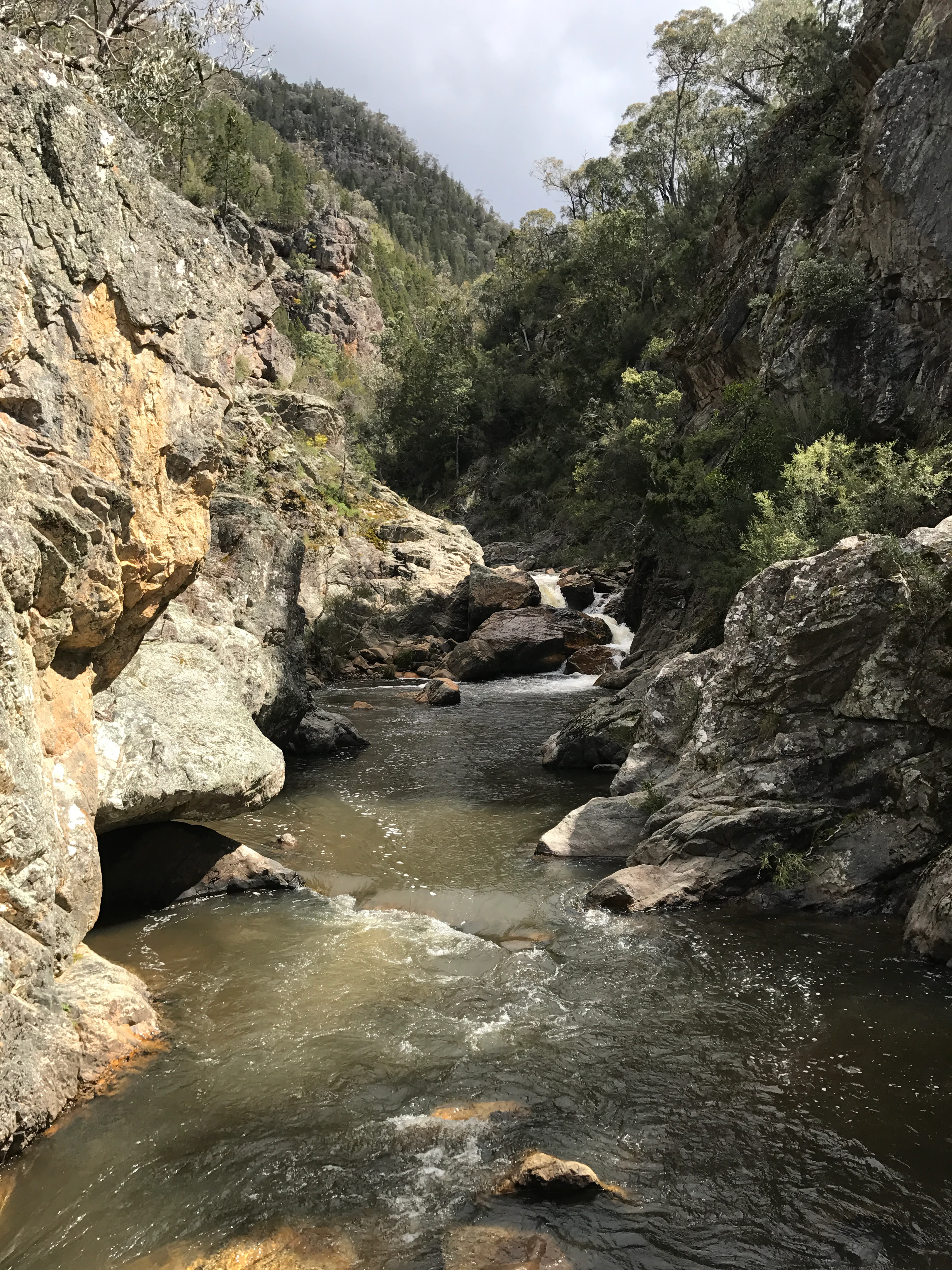
Wee Jasper Waterfalls
Rocky stream with small waterfalls in Wee Jasper Nature Reserve

Wee Jasper Nature Reserve history and protected-area timeline

Wee Jasper Nature Reserve was formally established in November 1979, when an initial area of around 426 hectares was set aside for nature conservation in the Southern Tablelands of New South Wales. The reserve was created as part of the broader system of protected areas managed by the NSW National Parks and Wildlife Service.

In 1986, a significant addition of approximately 205 hectares expanded the reserve, strengthening its capacity to represent the full range of forest communities present in the area. A further small addition of around 1.7 hectares was made in July 2001, refining the boundary and consolidating protection.

Since its establishment, the reserve has gained additional recognition for its conservation values, particularly the presence of threatened plant species. This has reinforced its classification as a strict nature reserve, dedicated to the long-term preservation of native flora, fauna, and ecological processes in the Wee Jasper region.

Wee Jasper Nature Reserve landscape and geographic character

The reserve sits within the gently undulating hill country of the Southern Tablelands of New South Wales, near the Goodradigbee River corridor and the wider catchment associated with Burrinjuck Dam. The terrain is shaped by rolling slopes, small valleys, and shallow drainage lines, with elevation differences between ridges and creeks producing a range of microclimates.

Slope aspect plays a particularly important role in shaping the physical setting. South-east facing slopes in the southern part of the reserve support moister, grassier forest communities, while east-facing slopes carry moderately exposed woodlands, and west-facing slopes in the south hold drier grassy forest types. The valley floor along Wee Jasper Creek supports a distinct riparian environment defined by river she-oak.

The combination of varied slopes, creek lines, and proximity to the broader river system gives the small reserve a layered physical landscape. Although the scale is limited, the variation in aspect and drainage produces a clear pattern of contrasting vegetation zones across short distances, which is one of the defining landscape characteristics of the area.

Wee Jasper Nature Reserve ecosystems, habitats, and plant life

Wee Jasper Nature Reserve protects four distinct forest ecosystems within its boundaries, a level of ecological diversity that is notable for an area of its size. Each ecosystem corresponds closely to a specific physical setting, illustrating how slope, exposure, and drainage shape woodland vegetation in this part of the Southern Tablelands.

On south-east facing slopes in the southern part of the reserve, an Apple box and Norton's box moist grass forest community occurs, taking advantage of cooler and more sheltered conditions. On moderately exposed east-facing slopes, a Brittle gum, broad-leaved peppermint, and Poa grass forest community dominates, reflecting the slightly drier, more open conditions of those hillsides.

A third community, characterised by Norton's box and Poa grass forest, occupies west-facing slopes in the south of the reserve, where solar exposure and drainage patterns produce yet another woodland composition. Along the corridor of Wee Jasper Creek in the south of the reserve, a distinct river she-oak forest community occurs, marking the transition from slope woodland to riparian vegetation.

Together these ecosystems form a compact but representative sample of Southern Tablelands woodland and forest types. Their close proximity within a single reserve makes the area particularly useful for ecological comparison and for understanding how minor physical differences produce distinct vegetation communities.

Wee Jasper Nature Reserve wildlife and species highlights

Wildlife records for Wee Jasper Nature Reserve include around sixty species of animal identified within its boundaries. While the reserve is more strongly recognised for its botanical values than its faunal ones, the diversity of habitats, including slope woodlands, grassy forests, and riparian she-oak communities, provides conditions for a range of native fauna typical of the Southern Tablelands.

The presence of varied vegetation structure, from moister south-facing forests to drier grassy woodlands and creek-line habitat, supports a mix of bird species, small mammals, reptiles, and invertebrates associated with eucalypt woodland environments in inland New South Wales. The reserve's strict protection status also means that fauna populations occur within habitat that is shielded from major land-use changes in the surrounding region.

Wee Jasper Nature Reserve conservation status and protection priorities

Wee Jasper Nature Reserve is significant from a conservation perspective because it concentrates multiple rare and threatened plant species within a small, highly protected area. The reserve holds records of the rare Australian anchor plant and limestone brittle-moss, as well as populations of the Yass daisy, which is listed as vulnerable under the New South Wales Threatened Species Conservation Act 1995.

The reserve is also a key site for the protection of two species listed as endangered under the same legislation: the Wee Jasper grevillea, a species closely associated with this locality, and the formbe pepper-cress. The presence of multiple threatened taxa within a single reserve underscores the importance of Wee Jasper for regional biodiversity conservation in the Southern Tablelands.

Around this botanical importance, the reserve's strict nature reserve status provides a high level of habitat protection. By limiting development and managing the land primarily for ecological values, the reserve helps safeguard the long-term survival of these threatened species and the forest communities on which they depend.

Top sights and standout views in Wee Jasper Nature Reserve

Wee Jasper Nature Reserve stands out for the unusual concentration of threatened plant species within a small area of Southern Tablelands forest. Its populations of the Yass daisy, the locally significant Wee Jasper grevillea, and other rare plants give it a botanical profile well beyond what its size alone would suggest.

The reserve's four distinct forest ecosystems, each tied to a specific combination of slope aspect and drainage, also make it a strong example of how ecological variation can be preserved in compact protected areas. Its strict nature reserve classification reinforces the durability of this protection for the long term.

Best time to visit Wee Jasper Nature Reserve

Information about seasonal access patterns and visitor conditions at Wee Jasper Nature Reserve is limited in publicly available sources. Visitors interested in the reserve should generally treat it as a low-key conservation area rather than a developed recreation destination, and plan visits around mild conditions typical of the Southern Tablelands, when bushland scenery, wildflowers, and forest atmosphere are most accessible.


Monthly climate preview

Long-term monthly temperature and precipitation patterns across the reserve

Wee Jasper Nature Reserve Climate Normals and Annual Temperature Rhythm

Representative coordinate records show measured monthly temperature and precipitation averages spanning thirty years of observation at Wee Jasper Nature Reserve. Examining the full twelve-month profile reveals detailed shifts in average temperature and precipitation across the regional landscape.
Annual mean14 °C
6 °C22 °C
Jan22°
Feb21°
Mar18°
Apr14°
May10°
Jun
Jul
Aug
Sep10°
Oct13°
Nov17°
Dec20°
Warmest month
January

22.4 °C

Coolest month
July

5.7 °C

Wettest month
November

2.3 mm/day

Driest month
April

1.1 mm/day

Park location guide

Geography guide, regional context, and park location map for Wee Jasper Nature Reserve

Wee Jasper Nature Reserve park geography, regions, and map view in Australia

Understand where Wee Jasper Nature Reserve sits in Australia through a broader geographic reading of the surrounding landscape, nearby location context, and its mapped position within the national park landscape.

How Wee Jasper Nature Reserve fits into Australia

Australia is a constitutional monarchy and federal parliamentary democracy comprising six states and ten territories. With a population of nearly 28 million, it is one of the world's most urbanised countries, with most people concentrated on the eastern seaboard. The country has a high Human Development Index and is known for its cultural diversity, ancient Aboriginal heritage, and unique wildlife.

Wider geography shaping Wee Jasper Nature Reserve in Australia

Australia occupies the entire Australian continent, the island of Tasmania, and numerous smaller islands. It is the world's flattest and driest inhabited continent, featuring vast deserts in the interior (the Outback), tropical rainforests along the eastern coast, and a coastline bordering the Indian and Pacific Oceans.

Map view of Wee Jasper Nature Reserve

Use this park location map to pinpoint Wee Jasper Nature Reserve in Australia, understand its exact geographic position, and read its mapped placement within the surrounding landscape more clearly.

Pigeon | © OpenStreetMap contributors

Location context for Wee Jasper Nature Reserve

New South Wales
Recorded earthquake history

Examine Historical Seismic Data for Wee Jasper Nature Reserve

Access a detailed catalogue of recorded seismic events associated with the geography of Wee Jasper Nature Reserve. Explore event documentation including magnitude, depth, and distance to understand the historical seismic profile of this Southern Tablelands protected area.

Wee Jasper Nature Reserve Earthquake History

Catalogued events

3 events

Strongest magnitude

Magnitude 3.7

Most recent event

Apr 19, 2012

This history includes earthquakes recorded inside the park or within 50 km of its borders

Visual reference of Southern Tablelands forest habitats and woodland terrain

Wee Jasper Nature Reserve Photos, Landscapes, and Protected Area Scenery

Visual records capture the undulating hill country, eucalyptus woodland, and riparian she-oak habitats across the protected reserve. Photographic documentation reveals how slope aspect and drainage shape the diverse vegetation zones of the Southern Tablelands.

Wee Jasper Waterfalls

Park atlas

Compare nearby Southern Tablelands conservation reserves and forest habitats

Parks Near Wee Jasper Nature Reserve and Surrounding Protected Areas

Continue exploring protected areas near Wee Jasper Nature Reserve to discover other woodland ecosystems across the Southern Tablelands. Comparing adjacent forest reserves reveals broader patterns in regional plant diversity and river valley geography.
Nature reserveNew South Wales
About 2.9 km away#1 closest

North

Oak Creek Nature Reserve: Regional Forest Conservation and Geographic Mapping

Strictly protected eucalypt forest in the Southern Tablelands

Oak Creek Nature Reserve represents an ecologically focused protected area within southeastern Australia. Spanning roughly 400 hectares of forest and woodland, this nature reserve illustrates the critical role of small, strictly managed sites in maintaining habitat connectivity across the diverse topography of the New South Wales Southern Tablelands region.

Area
4.04 km²
Established
2001
IUCN
Ia
Scope
Terrestrial
National parkNew South Wales
4 km away#2 closest

Southeast

Brindabella National Park: A Protected Mountain Landscape in New South Wales' Australian Alps

Discover its mapped terrain and regional geographic context.

Brindabella National Park offers a unique perspective on the mountainous terrain of the Brindabella Range, forming a vital protected area within the Australian Alps. Located in New South Wales, its landscape features rugged ridgelines and diverse subalpine vegetation, recognized for its national environmental significance. This park serves as a key destination for understanding protected area geography and the mapped context of Australia's high country.

Area
184.54 km²
Established
1996
IUCN
II
Relief
Mountain
Nature reserveNew South Wales
About 7.1 km away#3 closest

Northwest

Black Andrew Nature Reserve: Protected Landscape and Geographic Mapping in New South Wales

Strict conservation habitat within the Murrumbidgee River catchment

Black Andrew Nature Reserve features an intricate landscape of undulating slopes and riparian gullies on the south west slopes of New South Wales. The reserve is notable for its high botanical richness, with seven distinct vegetation communities mapped across substrates that range from granite to basalt. This protected area provides essential habitat for multiple threatened species while maintaining vital forest connectivity along the Burrinjuck Dam shoreline.

Area
15.59 km²
Established
2001
IUCN
Ia
Relief
Upland
Nature reserveNew South Wales
About 15 km away#4 closest

North

Burrinjuck Nature Reserve: Protected Inland Forest Geography and Conservation Mapping

Diverse eucalypt forest mosaic in the south west slopes of New South Wales

Located within the south west slopes of New South Wales, Burrinjuck Nature Reserve is a significant protected landscape known for its remarkably high diversity of forest types in a compact area. From moist grass forests to heathy woodlands, the reserve provides critical habitat for threatened plant populations and an unusually rich variety of woodland birds. Its terrain offers a glimpse into the ecological complexity of inland Australian catchments and ridge systems.

Area
52.5 km²
Established
1984
IUCN
Ia
Relief
Upland
Watercolor painting showing mountains, fields, and a river
National parkNew South Wales
23 km away#5 closest

South

Kosciuszko National Park: Australia's Highest Alpine Terrain and Mapped Protected Landscape

Discover unique glacial landscapes and geographic context in New South Wales.

Kosciuszko National Park represents the pinnacle of Australia's alpine geography, preserving the continent's only true alpine ecosystems. This extensive national park in New South Wales features dramatic glacial landforms, including its namesake Mount Kosciuszko, Australia's highest peak. Users can explore the park's mapped boundaries, surrounding natural terrain, and unique landscape features for a comprehensive understanding of this significant protected area.

Area
6,900 km²
Established
1944
IUCN
II
Visitors
3.3M annual
National parkAustralian Capital Territory
24 km away#6 closest

Southeast

Namadgi National Park: Protected Landscape and Geographic Context in Australian Capital Territory

Explore the mapped boundaries and regional geography of this national park.

Namadgi National Park is a designated national park situated in the Australian Capital Territory. This dedicated page offers detailed information on its protected status, geographic features, and its role within the regional landscape atlas of Australia. Dive into the mapped terrain and understand the park's environmental significance and its contribution to the conservation landscape of the Australian Capital Territory.

Area
1,060.95 km²
Established
1984
IUCN
II
Relief
Mountain
Nature reserveAustralian Capital Territory
About 43 km away#7 closest

Southeast

Tidbinbilla Nature Reserve Protected Area: Landscape and Geographic Context

A vital conservation valley in the Australian Capital Territory

Tidbinbilla Nature Reserve functions as a significant ecological anchor on the fringe of the Australian Capital Territory. Defined by the contrast between deep valley basins and steep escarpments, this nature reserve integrates long-standing Aboriginal heritage with ongoing conservation programs for native wildlife in a rugged bushland environment.

Area
54.5 km²
Established
1971
IUCN
II
Relief
Mountain
Nature reserveAustralian Capital Territory
44 km away#8 closest

East

Mulligans Flat Woodland Sanctuary: A Detailed Geographic and Protected Landscape Overview

Ecological restoration and woodland geography in the Australian Capital Territory

Mulligans Flat Woodland Sanctuary operates as a fenced nature reserve in northern Canberra, protecting expansive grassy woodland habitats and native ecosystems. The site provides a unique look at temperate woodland recovery, featuring a diverse mix of remnant eucalypt forests, seasonal wetlands, and volcanic terrain that serves as a key component of regional ecological connectivity.

Area
12.53 km²
Established
1994
IUCN
IV
Relief
Upland

Common questions about visiting, size, designation, and location context for Wee Jasper Nature Reserve

Wee Jasper Nature Reserve FAQs for park facts, access, geography, and protected area context

Find quick answers about Wee Jasper Nature Reserve, including protected-area facts, park geography, trail and visitor context, and how the park fits into its surrounding country and regional landscape.
MoriAtlas Explorer

Continue Your Protected Areas Search Across the Global Atlas

Deepen your exploration by continuing the structured search for national parks and protected areas worldwide. Utilize the comprehensive filtering capabilities to compare different conservation landscapes and refine your understanding of global park geography. Discover more about the distribution and characteristics of protected natural areas.

Global natural geography