
Mori Atlas logo
Nature reserveWeißer Graben

Analyzing the ecological boundaries and renaturation zones within the Lichtenmoor peatland complex

Weißer Graben Nature Reserve: Protected Peatland Landscapes and Regional Geography Map

(Naturschutzgebiet Weißer Graben (NSG HA 174))

Weißer Graben is a significant nature reserve situated in Landkreis Nienburg/Weser, Lower Saxony, representing a complex mosaic of restored peatland, birch swamp forests, and wet meadows. This atlas-focused entry details the two distinct parcels that compose the reserve, highlighting its role in the wider Lichtenmoor landscape. By tracing the hydrology of the Alpegraben and Weißer Graben streams, users can examine the connection between industrial peat cutting legacies and modern habitat restoration for meadow bird species.

peatlandraised bogrenaturationwet grasslandmeadow birdsbirch swamp forest
A stylized vector illustration of a mountain valley featuring dramatic cliffs, evergreen trees, and a small waterfall, rendered in a soft pastel color palette.

Weißer Graben

Nature reserve

Park overview

Structured park overview, official facts, and landscape profile for Weißer Graben Nature Reserve

Weißer Graben Nature Reserve park facts, protected area profile, and essential visitor context

Review the core facts for Weißer Graben Nature Reserve, including designation, size, terrain, visitor scale, habitats, and operating context in one park-focused overview.

About Weißer Graben Nature Reserve

Weißer Graben is a Lower Saxon nature reserve focused on the conservation of a raised bog landscape in the Lichtenmoor, a broad peatland area between Nienburg/Weser and Steimbke. Although small compared with major national parks, the reserve carries meaningful ecological importance because it combines active restoration of damaged peatland with the long-term protection of a more natural bog mosaic, all within a working agricultural and forest landscape.

The reserve stretches across parts of the Samtgemeinde Heemsen and the Samtgemeinde Steimbke and consists of two non-contiguous sections. Its geography is typical of the northwestern German plain: low elevation, gently undulating peatland, slow-moving drainage ditches, and a patchwork of open marshy meadows, regenerating bog surfaces, and bog woodland.

The core identity of the area lies in the contrast between its two halves. The southwestern part tells the story of industrial peat exploitation, with large sections that were once cut for fuel and horticulture now being brought back to a more functional bog state through rewetting and conversion to wet grassland. The northeastern part, by contrast, retains more of the original structure, including birch swamp forests that have regrown naturally on old peat soils, hand-cut peat pits of historical origin, and a varied mix of lightly and more intensively used farmland.

The reserve is also defined by its hydrology. Two small streams, the Alpegraben and the Weißer Graben, run through the area and ultimately feed into the Alpe and Wölpe, both tributaries of the Aller. This water network is essential to the regeneration of the bog and to the wet grassland that supports the reserve's meadow bird populations.

Quick facts and research context for Weißer Graben Nature Reserve

Weißer Graben is a designated nature reserve in the district of Nienburg/Weser in Lower Saxony, Germany, classified under IUCN Category IV as a Habitat/Species Management Area. Its official designation is NSG HA 174 and it has been under protection since 11 May 1995.

The reserve covers approximately 502 hectares and consists of two separate parcels. It protects a raised bog landscape embedded in the larger Lichtenmoor area, including formerly industrially cut peatlands now in renaturation and a northeastern section with intact birch swamp forest. Management is led by the district of Nienburg/Weser as the responsible lower nature protection authority, with the NLWKN providing oversight.

Protection and recognition

Examining documented protected area designation records and regulatory status

Weißer Graben Protection Status and International Recognition Data

Examine official records detailing the administrative protection status and regulatory designation parameters established for Weißer Graben. Review structured conservation metrics and international database identifiers compiled for protected area research.

Protection details

WDPA ID
166233
Park context

Deeper park guide and search-rich context for Weißer Graben Nature Reserve

Weißer Graben Nature Reserve history, landscape, wildlife, and travel context

Explore Weißer Graben Nature Reserve through its history, landscape character, ecosystems, wildlife, conservation priorities, cultural context, and seasonal travel timing in a structured park guide built for atlas discovery and search intent.

Why Weißer Graben Nature Reserve stands out

The reserve is best known for its combination of active peatland renaturation and the protection of meadow bird habitat in wet grassland. The southwestern portion has become a notable example of how industrially cut high moor can be rewetted and restored, while the more structurally diverse northeastern section offers a mix of birch swamp forest, traditional hand peat cuttings, and meadows of different intensities. It is also valued for its integration within the wider Lichtenmoor landscape, an important peatland complex in the northern German lowlands, and for the conservation role played by its small waterways, the Alpegraben and Weißer Graben, in maintaining the hydrology that the bog ecosystem depends on.
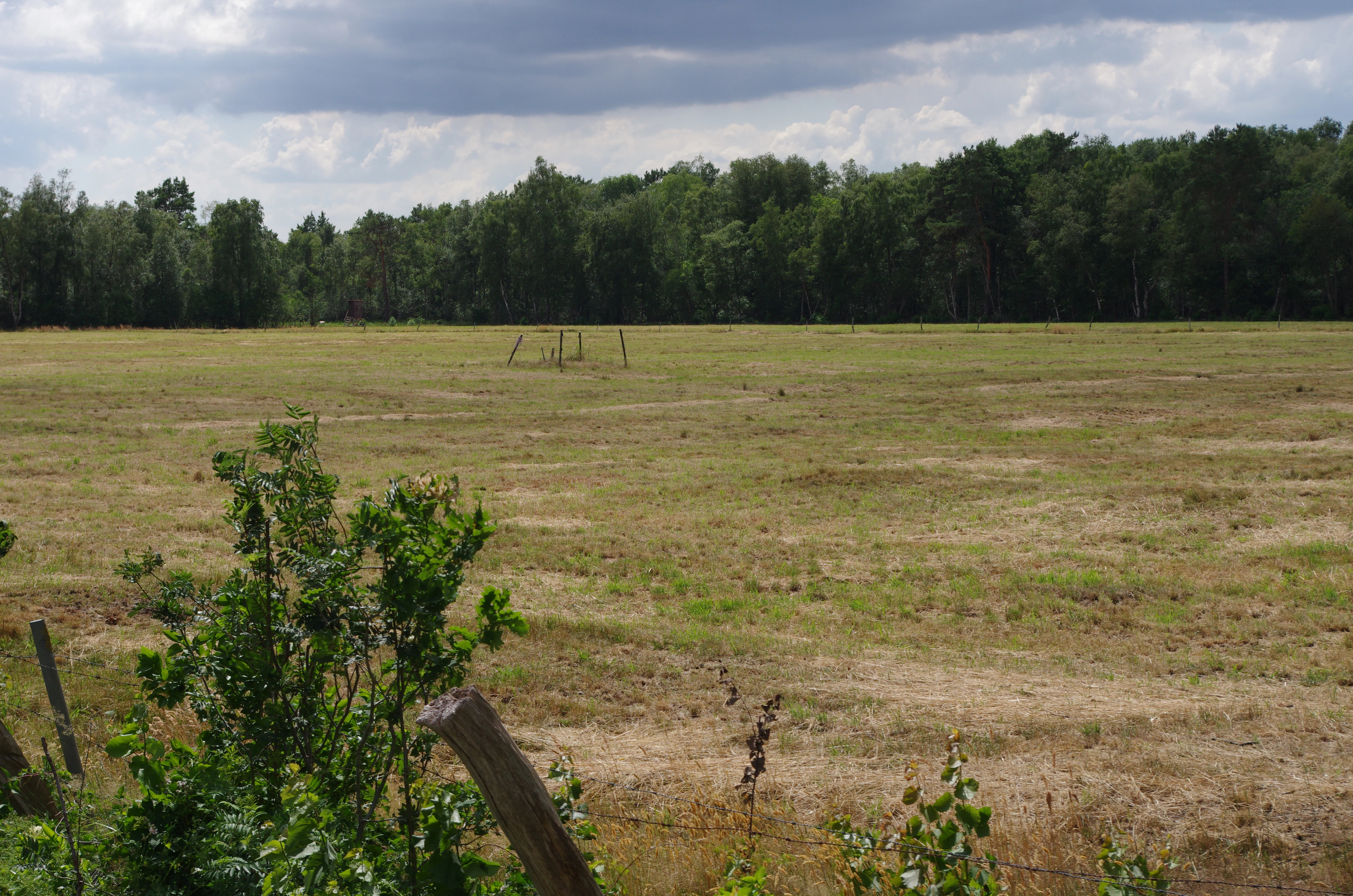
A wide shot of an open, dry, grassy field bordered by a dense green forest under a cloudy sky.
A wide view of the open landscape and bordering forest at the Weißer Graben nature reserve.

Weißer Graben Nature Reserve history and protected-area timeline

The area that is now Weißer Graben has a long history of peat-related human activity. Before modern protection, parts of the Lichtenmoor, including the southwestern zone of the present reserve, were subjected to large-scale industrial peat cutting for commercial use.

A second layer of historical land use is visible in the northeastern section, where older hand-dug peat cuttings survive alongside naturally established birch swamp forests. These hand cuttings reflect a traditional, lower-impact form of peat extraction that contrasted sharply with later industrial operations and now form part of the area's cultural landscape heritage.

The turning point in the reserve's modern history came on 11 May 1995, when the area was formally designated under the official code NSG HA 174. Designation brought the active management responsibility for the former peat cuttings, the surviving wet grassland, and the bog woodland under the protection framework of Lower Saxony's Naturschutzgebiet system, with the district of Nienburg/Weser as the responsible lower nature protection authority and the NLWKN providing statewide oversight.

Weißer Graben Nature Reserve landscape and geographic character

The landscape of Weißer Graben is a classic example of the northern German lowland peatland environment. Elevations across the reserve range only from about 24 to 34 metres above sea level, producing the flat, slightly undulating terrain typical of raised bogs that have formed in former glacial and post-glacial wetland basins.

The southwestern parcel shows clear signs of its industrial peat-cutting past. Vast open surfaces, drained channels, and altered microtopography dominate the view, with many areas converted to moist grassland or actively managed through rewetting to encourage bog regeneration.

The northeastern parcel has a more varied and visually richer structure. Here, regenerating birch swamp forests form a low, dense canopy over peat soils, interspersed with shallow pools from historic hand-dug peat pits. Around and between these wooded patches lie meadows and pastures of different use intensities, occasionally broken by small arable fields and forested strips. Streams and drainage ditches, especially the Alpegraben and the Weißer Graben itself, weave through the area and reinforce the wet, open character of the landscape.

Weißer Graben Nature Reserve ecosystems, habitats, and plant life

Ecologically, the reserve is defined by its peatland character. The fundamental ecosystem is the raised bog, a habitat built up over centuries from successive layers of sphagnum and other mosses and partially decomposed plant material. Even where the bog surface has been disturbed, the underlying peat soils and the hydrology that feeds them remain the defining ecological feature.

The current vegetation pattern is strongly tied to human history. In the southwest, former peat cuttings now support a mix of regenerating bog vegetation and cultivated wet grassland, actively shaped by rewetting measures that aim to restore the original water regime. In the northeast, the birch swamp forests represent a later successional stage of bog development, where bog woodland has re-established itself naturally over old peat soils.

Interspersed with these forested and rewetted zones are wet meadows of varying intensity, small arable patches, and patches of forest plantation. This mosaic is what gives the reserve its high structural diversity and makes it especially valuable for species that require a combination of open wet ground, taller vegetation, and transitional edge habitats.

Weißer Graben Nature Reserve wildlife and species highlights

The reserve's wildlife significance is tied primarily to its wet grassland and bog habitats. The active improvement of moist meadows as habitat for meadow birds (Wiesenvögel) is an explicit conservation goal of the area, reflecting the importance of open, structurally diverse wet grasslands for species that depend on regularly mowed or lightly grazed meadows.

The mosaic of wet meadows, regenerating bog surfaces, drainage ditches, and birch swamp woodland creates habitat for a broader community of wetland-associated fauna. The small streams and ditches that run through the area also support aquatic and semi-aquatic life typical of lowland peatland catchments in northwestern Germany.

Although the reserve is relatively small and intensively managed compared with wilderness reserves, its combination of actively restored peatland, permanent wet grassland, and structurally rich bog woodland gives it a meaningful role for biodiversity at the regional scale, especially within the Lichtenmoor peatland complex.

Weißer Graben Nature Reserve conservation status and protection priorities

From a conservation perspective, Weißer Graben is significant both for what it protects and for what it actively restores. The designation as a Naturschutzgebiet under Lower Saxony's nature protection framework places it in the country's principal category for area-based species and habitat protection, and its IUCN Category IV classification reflects its role as a Habitat/Species Management Area.

Restoration is a central pillar of the reserve's conservation work. The formerly industrially cut peatlands in the southwest are being recovered through rewetting and conversion into wet grassland, partly in cooperation with landowners. Together with the undisturbed bog woodland and meadows in the northeast, this makes the reserve an important example of integrated peatland conservation in the Lichtenmoor area.

The reserve's hydrology is itself a conservation asset. The Alpegraben and Weißer Graben, both of which flow through the protected area, link it to a larger network of streams that ultimately connect to the Alpe, the Wölpe, and the Aller. Maintaining the water balance of these streams is essential to the long-term success of both the bog renaturation and the wet grassland management on which meadow bird conservation depends.

Weißer Graben Nature Reserve cultural meaning and human context

The area around Weißer Graben carries a layered cultural history of human interaction with peatland. The surviving hand-dug peat cuttings in the northeastern section are evidence of an older, locally embedded way of using the bog, in which small-scale peat extraction was part of the rural economy and everyday practice.

Later, the industrial peat cutting that shaped large parts of the southwestern zone represented a more modern, mechanised phase of the same land use tradition. The current renaturation effort can therefore be read both as an ecological restoration and as a shift in the long relationship between local communities and the Lichtenmoor landscape.

While the reserve today is primarily a conservation landscape rather than a living cultural site, its management ethos, which combines ecological restoration with continued low-intensity agricultural and forestry use, reflects a regional tradition of working with, rather than excluding people from, protected peatlands.

Top sights and standout views in Weißer Graben Nature Reserve

Weißer Graben stands out for combining active peatland restoration with the protection of wet grassland meadow bird habitat within a single, manageable reserve. Its two-part structure offers an unusually clear contrast between disturbed, recovering peatland and more intact bog woodland with historic hand peat cuttings.

The reserve is also notable for its place within the broader Lichtenmoor peatland complex, one of the more important peatland landscapes in Lower Saxony, and for the role played by its streams in sustaining the hydrology of both the bog and its associated wet meadows.

Best time to visit Weißer Graben Nature Reserve

The character of a visit to Weißer Graben is shaped most strongly by the seasons of the northern German lowlands. Spring and early summer are typically the most rewarding periods for observing wet grassland and meadow bird activity, when the meadows are at their greenest and the bird life associated with open wet habitats is most active.

Late spring and summer also tend to be the best times to appreciate the contrast between the two halves of the reserve, with the regenerating bog surfaces in the southwest and the leafy birch swamp forests in the northeast both in full growth. Autumn and winter bring a quieter, more open atmosphere, with frost-sensitive bog surfaces and reduced vegetation cover making the area's hydrology and surface structure easier to read in the landscape.


Monthly climate preview

Long-term monthly temperature and precipitation patterns recorded at baseline coordinates

Weißer Graben Climate Normals and Annual Temperature Rhythm

Representative coordinate records show measured monthly temperature ranges and daily precipitation rates across the sampled baseline. Examining the complete twelve-month climatology profile reveals detailed shifts in average temperature and precipitation normals.
Annual mean9 °C
1 °C18 °C
Jan
Feb
Mar
Apr
May13°
Jun16°
Jul18°
Aug18°
Sep14°
Oct10°
Nov
Dec
Warmest month
July

18.4 °C

Coolest month
January

0.6 °C

Wettest month
July

2.4 mm/day

Driest month
April

1.4 mm/day

Park location guide

Geography guide, regional context, and park location map for Weißer Graben Nature Reserve

Weißer Graben Nature Reserve park geography, regions, and map view in Germany

Understand where Weißer Graben Nature Reserve sits in Germany through a broader geographic reading of the surrounding landscape, nearby location context, and its mapped position within the national park landscape.

How Weißer Graben Nature Reserve fits into Germany

Germany is a federal republic in Western and Central Europe with a population of over 83 million across sixteen constituent states. It is Europe's largest economy by nominal GDP and a major global exporter and importer. The capital is Berlin, and the country borders Denmark, Poland, Czech Republic, Austria, Switzerland, France, Luxembourg, Belgium, and the Netherlands.

Wider geography shaping Weißer Graben Nature Reserve in Germany

Germany is located in Western and Central Europe, spanning 357,022 km². It borders Denmark to the north, Poland and the Czech Republic to the east, Austria and Switzerland to the south, and France, Luxembourg, Belgium, and the Netherlands to the west. The country has coastlines on the Baltic Sea and North Sea to the north, with the Alps located in the southern region.

Map view of Weißer Graben Nature Reserve

Use this park location map to pinpoint Weißer Graben Nature Reserve in Germany, understand its exact geographic position, and read its mapped placement within the surrounding landscape more clearly.

Pigeon | © OpenStreetMap contributors

Location context for Weißer Graben Nature Reserve

Landkreis Nienburg/Weser

Visualizing the raised bogs, birch swamp forests, and protected wetland terrain

Weißer Graben Photos and Landscape Scenery in Lower Saxony

Visual records capture the distinctive lowland terrain, regenerating peatlands, and birch swamp forests that define the protected environment of Weißer Graben. Examining these natural habitats and wetland features helps visitors understand the ecological character and ongoing restoration work across the reserve.

A wide shot of an open, dry, grassy field bordered by a dense green forest under a cloudy sky.

Park atlas

Compare regional lowland wetlands, raised bogs, and connected conservation landscapes.

Exploring Parks Near Weißer Graben and Surrounding Lower Saxony Protected Areas

Browse protected areas and lowland nature reserves located close to Weißer Graben in northern Germany. Comparing adjacent wetland terrain and regional peatland geography helps trace wider ecological patterns across the district.
Nature reserveLower Saxony
About 17 km away#1 closest

Northwest

Wiedesee Nature Reserve: Mapped Geography and Protected Landscapes in Lower Saxony

A compact waterbird habitat in the Lower Saxony agricultural region

Wiedesee stands as a refined example of a managed nature reserve in Germany. Spanning 26 hectares, this former quarrying lake is defined by its concentric transition from open water and reed belts to wet meadow fringes. The site serves as a vital island of biodiversity, offering a clear case study in how active conservation interventions support migratory bird species within an otherwise intensively farmed landscape.

Area
0.26 km²
Established
1984
Water
Water-dominated
Nature reserveLower Saxony
About 22 km away#2 closest

South

Steinhuder Meer mit Randbereichen: Protected Nature Reserve and Wetland Geography

Lowland lake, fen meadows, and bog ecosystems in Lower Saxony

Steinhuder Meer mit Randbereichen stands as a primary conservation site in northwestern Germany. The protected landscape combines a vast, shallow lowland lake with extensive reed belts and peatland remnants, creating a complex wetland gradient that defines the regional geography of the Weser-Aller lowlands.

Area
53.71 km²
Established
2004
Nature reserveNienburg/Weser
About 23 km away#3 closest

Southwest

Wellier Schleife/Staustufe Landesbergen: A Protected River Oxbow and Floodplain Geography

Mapping protected habitats in the Middle Weser valley of Germany.

This nature reserve protects the Wellier Schleife, a significant oxbow arm created by the Landesbergen weir. The 278-hectare area encompasses former gravel pits, wetland fringes, and agricultural floodplains. It stands as a vital component of the Wesertalaue bei Landesbergen bird protection network, reflecting the interplay between river engineering and conservation efforts.

Area
2.78 km²
Established
1996
IUCN
IV
Relief
Lowland
Nature reserveLower Saxony
About 24 km away#4 closest

North

Verdener Moor Nature Reserve: Geographic Atlas and Protected Area Context

Preserving raised bog ecosystems in Lower Saxony, Germany

Located in the municipality of Kirchlinteln, Verdener Moor functions as a protected nature reserve that demonstrates lowland peatland conservation. The landscape features a distinct mosaic of open water resulting from historical peat extraction, wet heath, and rewilded forest edges. This site offers valuable insight into the restoration of bog habitats through rewetting and bush removal within the broader geography of Lower Saxony.

Area
0.91 km²
Established
1989
IUCN
IV
Relief
Lowland
Nature reserveLower Saxony
About 28 km away#5 closest

South

Westufer Steinhuder Meer Nature Reserve: Geographic Profile and Wetland Boundaries

Protected mosaic of swamp forest and bog in Lower Saxony

Westufer Steinhuder Meer represents a significant wetland complex within the Natura 2000 network of Lower Saxony. The protected area features a unique concentric gradient ranging from lakeshore reedbeds to inland fen and bog forest. By mapping these interconnected peat habitats, the reserve highlights its role as a key stopover for migratory waterfowl and a sanctuary for rare breeding species on the North German Plain.

Area
6.63 km²
Established
2020
A wide panoramic watercolor illustration showing a winding river or stream flowing through a landscape of green pine trees and pink flowering bushes under a pale sky.
Nature reserveRegion Hannover
About 31 km away#6 closest

South

Wadebruch Nature Reserve: Geographic Analysis of a Lower Leine Floodplain Protected Area

A dense mosaic of alder swamps, oxbow channels, and sandy terrace forest in Germany.

Wadebruch serves as a compact, ecologically rich example of a lower Leine floodplain environment. Located in the Hannover Region, this protected site preserves a historic river meander, including an aging oxbow and alder swamp forest, contrasted against steep sandy banks. The site provides essential insights into the natural river patterns that once characterized this part of Lower Saxony.

Area
0.16 km²
Established
1985
IUCN
IV
Relief
Lowland
Nature reserveNiedersachsen
About 32 km away#7 closest

North

Waller Flachteiche Nature Reserve: Exploring the Geography of Protected Landscapes in Niedersachsen

Mapped habitats of a former sand quarry wetland

Waller Flachteiche is a state-recognized nature reserve covering over 22 hectares of sandy, lowland terrain in Germany. The protected area offers a look at a recovered industrial site, where periodically drying ponds and diverse scrubland create a specialized habitat for rare amphibians and wetland flora. Its defined boundaries highlight a critical Natura 2000 component within the broader Niedersachsen region.

Area
0.227 km²
Established
2018
IUCN
IV
Nature reserveLower Saxony
About 32 km away#8 closest

North

Wedeholz Nature Reserve: Geographic Overview of Lower Saxony Protected Forest Landscapes

Ancient oak forests, Geest terrain, and protected wetland habitats

Wedeholz represents a dense forest conservation area in Lower Saxony, defined by its mature oak and beech communities. The reserve terrain transitions from dry sandy Geest soils to delicate pine swamp forests and floating bogs, supporting a high density of deadwood-dependent species and woodland biodiversity within a compact, protected boundary.

Area
1.83 km²
Established
2019
IUCN
IV
Relief
Upland

Common questions about visiting, size, designation, and location context for Weißer Graben Nature Reserve

Weißer Graben Nature Reserve FAQs for park facts, access, geography, and protected area context

Find quick answers about Weißer Graben Nature Reserve, including protected-area facts, park geography, trail and visitor context, and how the park fits into its surrounding country and regional landscape.
MoriAtlas Explorer

Continue Your Protected Areas Search Across the Global Atlas

Deepen your exploration by continuing the structured search for national parks and protected areas worldwide. Utilize the comprehensive filtering capabilities to compare different conservation landscapes and refine your understanding of global park geography. Discover more about the distribution and characteristics of protected natural areas.

Global natural geography