Mori Atlas logo
Nature reserveWeißeritztalhänge

Examining the ecological terrain, valley forest mosaic, and Wilde Weißeritz river corridor

Weißeritztalhänge Nature Reserve: Mapped Protected Landscapes and Regional Geography in Saxony

(Naturschutzgebiet Weißeritztalhänge)

Weißeritztalhänge constitutes a vital protected landscape at the northern edge of the Erzgebirge in Saxony. This nature reserve maps a complex intersection of slope forests and the Wilde Weißeritz river valley. The region presents a structurally diverse mosaic of forest communities, varying by elevation and aspect, creating a unique conservation corridor within the broader Saxon landscape.

forest reserveslope forestbeech forestmixed woodlandriver valleyWilde Weißeritz

Weißeritztalhänge

Nature reserve

Park overview

Structured park overview, official facts, and landscape profile for Weißeritztalhänge

Weißeritztalhänge park facts, protected area profile, and essential visitor context

Review the core facts for Weißeritztalhänge, including designation, size, terrain, visitor scale, habitats, and operating context in one park-focused overview.

About Weißeritztalhänge

Weißeritztalhänge is a long-established nature reserve in Sachsen, Germany, covering roughly 449 hectares of forest slopes and valley habitat along the Wilde Weißeritz on the northern edge of the Erzgebirge (Ore Mountains). It lies within the Landkreis Sächsische Schweiz-Osterzgebirge, branching out east and south of the town of Tharandt and north of Höckendorf in the municipality of Klingenberg. The protected landscape sits in the natural area known as the Dippoldiswalder Riedelland, more precisely the Tharandter Weißeritz-Tal micro-region, which is characterized by a steep transition from lowland to mid-mountain terrain.

The reserve's core value is ecological. Its slope forests vary considerably with altitude and aspect, producing a structurally complex landscape in which different woodland communities meet and intergrade. This makes it one of the more forest-diverse protected areas in the northern Erzgebirge foothills, and an important refuge for species that depend on continuous, mature, and structurally varied woodland habitat.

At the same time, the reserve protects the Wilde Weißeritz itself as a flowing water body with near-natural structure and dynamics. The combination of well-developed slope forests and an intact stream system creates the conditions for both forest-dependent and aquatic species to thrive in close proximity. The reserve was placed under protection in 1961, making it one of the older Naturschutzgebiete in the region, and today it sits within the wider Natura 2000 framework, contributing both to the Habitats Directive site and to the European bird protection area network.

Quick facts and research context for Weißeritztalhänge

Weißeritztalhänge is a German Naturschutzgebiet of about 448.6 hectares, identified as NSG D 38 and listed in the World Database on Protected Areas as WDPA 14511. It was designated in 1961 and is part of the Natura 2000 site DE-4947-301 "Täler von Vereinigter und Wilder Weißeritz", which in turn overlaps with the European bird protection area "Weißeritztäler". The reserve is assigned to IUCN Category IV (Habitat/Species Management Area) and lies in the natural region of the Dippoldiswalder Riedelland, specifically the Tharandter Weißeritz-Tal micro-region.

Protection and recognition

Terrestrial protected area records, management details, and recognition data

Weißeritztalhänge Protection Status and Documented Conservation Scope

Terrestrial conservation records outline the documented protection status and management scope established for Weißeritztalhänge. Official administrative data compiles available designation history and international recognition sources for structured analysis.

Protection details

Protection scope
Terrestrial
Transboundary protection
No
WDPA ID
14511
Park context

Deeper park guide and search-rich context for Weißeritztalhänge

Weißeritztalhänge history, landscape, wildlife, and travel context

Explore Weißeritztalhänge through its history, landscape character, ecosystems, wildlife, conservation priorities, cultural context, and seasonal travel timing in a structured park guide built for atlas discovery and search intent.

Why Weißeritztalhänge stands out

Weißeritztalhänge is best known for its extensive slope forests at the Erzgebirge northern edge, where variations in altitude and exposure create a rich patchwork of beech, oak-hornbeam, and ravine-mixed forest communities. The reserve is equally recognized for protecting the near-natural stretch of the Wilde Weißeritz, a stream whose dynamic structure remains largely intact and supports river-dwelling species of conservation concern. It also stands out as a refuge for forest-dwelling bats such as Bechstein's bat and the western barbastelle, and for breeding birds including the black woodpecker, grey-headed woodpecker, red kite, and Eurasian kingfisher.
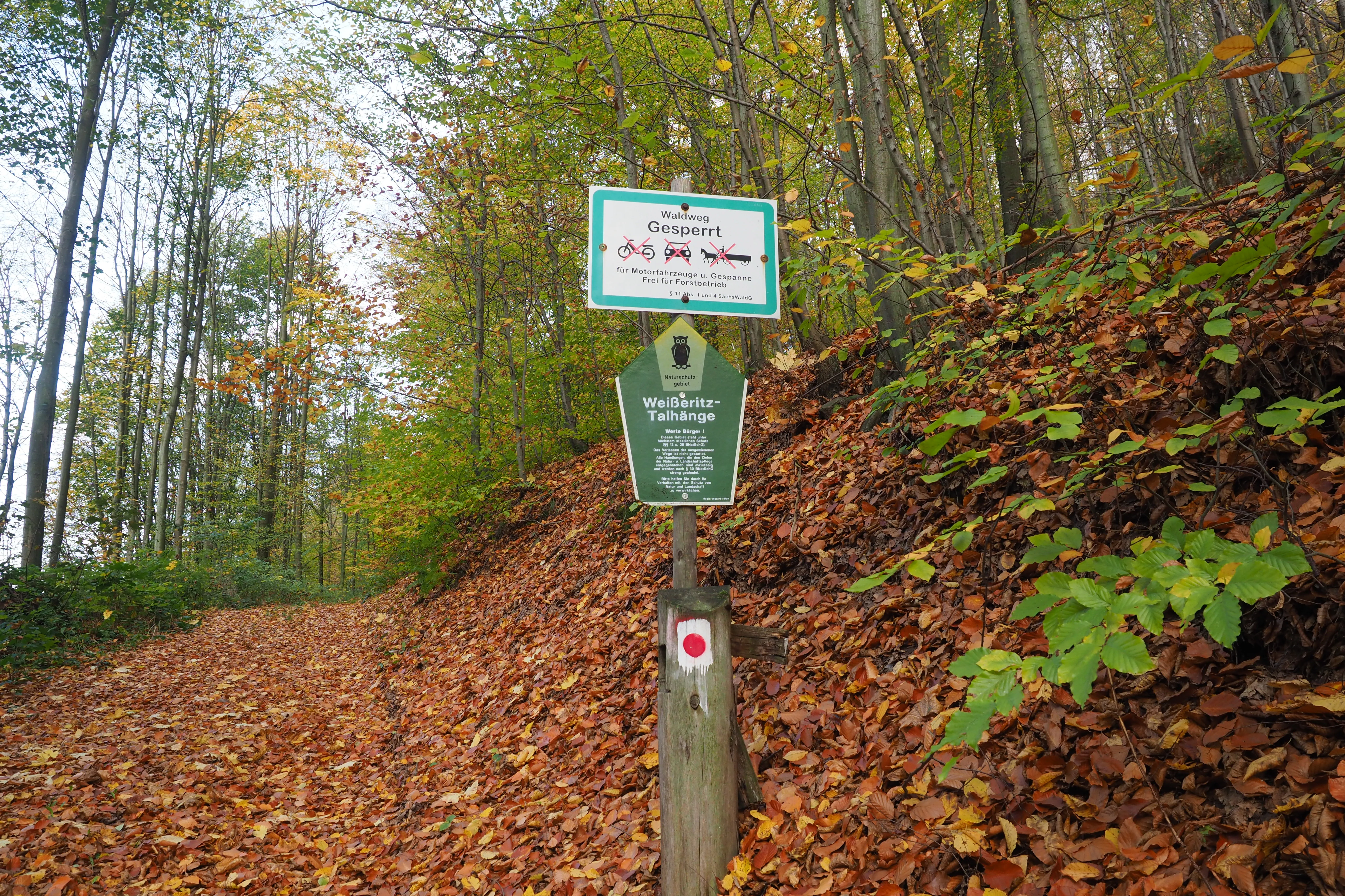
A wooden trail sign post with an information panel for the Weißeritztalhänge nature reserve and a red and white trail marker, standing on a forest path covered in autumn leaves.
A trail sign at the Weißeritztalhänge nature reserve marking restricted access.

Weißeritztalhänge history and protected-area timeline

Weißeritztalhänge was designated as a Naturschutzgebiet in 1961, placing a roughly 449-hectare section of forest and valley along the Wilde Weißeritz under formal protection. The designation predates many of the modern European conservation frameworks, but the site was later integrated into the Natura 2000 network as part of the Habitats Directive site "Täler von Vereinigter und Wilder Weißeritz" (DE-4947-301) and the associated bird protection area "Weißeritztäler".

The forest landscape itself carries traces of older human land use. Historical coppice-style management (Niederwaldbewirtschaftung) of the slopes left cultural-historically valuable use relicts that are recognized within the reserve's conservation purpose. Scholarly work on the reserve's forest soils, published by Fiedler, Hunger, and Hofmann in 1989, also documents long-running interest in the area's soils, land use, and soil protection, indicating that the reserve has been treated as a reference site for research and conservation management for several decades.

Weißeritztalhänge landscape and geographic character

The landscape of Weißeritztalhänge is shaped by the steep transition from the Saxon lowlands into the northern Erzgebirge. The reserve's two component areas follow the slopes of the valley of the Wilde Weißeritz as it cuts northward out of the Ore Mountains, with terrain that dips and rises with the irregular relief typical of the Dippoldiswalder Riedelland. East and south of Tharandt and north of Höckendorf, the protected area traces both the stream corridor and the surrounding wooded hillsides.

The terrain is defined more by wooded slopes than by open ground. Forest stretches across the valley flanks, while the stream itself runs through a narrow, partly rocky valley floor. Exposure and elevation differences across the slopes produce a visibly varied forest mosaic, ranging from sheltered ravine-like sites to drier, sun-exposed upper slopes. The combination of steep slopes, varied aspect, and a dynamic mountain stream gives the area a visually layered character with shifting forest types over short distances.

Weißeritztalhänge ecosystems, habitats, and plant life

Ecologically, Weißeritztalhänge is defined by its hill and slope forests, which form the largest share of the protected habitat and form a connective forest corridor (Leitenwaldkomplex) along the valley. Multiple forest community types occur here in close proximity, each tied to altitude and aspect. Hainsimsen beech forests, Waldmeister beech forests, Galium oak-hornbeam forests, and steep-slope ravine-mixed forests are all represented, creating a richly structured woodland mosaic.

The stream ecology of the Wilde Weißeritz adds a second major component. The reserve specifically aims to preserve and develop the river's near-natural structure and dynamics, which in turn supports sensitive aquatic species. Together, the forests and the river form a connected habitat complex that supports both woodland and riparian species of conservation concern, including habitat types and species listed under the European Habitats Directive.

Weißeritztalhänge wildlife and species highlights

Weißeritztalhänge supports a varied fauna shaped by its extensive mature forests and its near-natural river corridor. The reserve has documented populations of several bat species of European conservation concern, including Bechstein's bat, the greater mouse-eared bat, and the western barbastelle. The river habitat of the Wilde Weißeritz supports otter, the western bullhead, and the brook lamprey, along with the green snaketail dragonfly.

The birdlife of the reserve is equally notable. Breeding species include the Eurasian kingfisher along the stream, the red kite over the valley, and woodland specialists such as the black woodpecker, grey-headed woodpecker, and red-breasted flycatcher in the older forest stands. Eagle owls have also been observed displaying in the area, indicating the presence of suitable large forest tracts and cliff-like or woody structures for nesting.

Weißeritztalhänge conservation status and protection priorities

Weißeritztalhänge has conservation significance that extends well beyond its formal designation as a Naturschutzgebiet. As a large, structurally diverse forest complex at the Erzgebirge northern edge, it serves as a refuge for woodland habitat types of European importance, including Hainsimsen beech forests, Waldmeister beech forests, Galium oak-hornbeam forests, and steep-slope ravine-mixed forests.

Its integration into the Natura 2000 network through the FFH site "Täler von Vereinigter und Wilder Weißeritz" and the bird protection area "Weißeritztäler" anchors the site in the European-wide conservation framework and connects it to broader efforts to protect forest and river habitats across the northern Erzgebirge.

The official conservation purpose of the reserve emphasizes the long-term maintenance and documentation of a species-rich forest mosaic, the preservation of the near-natural structure and dynamics of the Wilde Weißeritz, and the safeguarding and promotion of indigenous plant and animal populations and their habitats within a wider regional connection. The persistence of relicts of historical coppice woodland management also adds a cultural-ecological layer to the conservation value of the area.

Top sights and standout views in Weißeritztalhänge

Among the strongest distinguishing features of Weißeritztalhänge are its large, species-rich slope forests, which vary with elevation and exposure to form a rare structural mosaic along the Erzgebirge northern edge. The reserve protects multiple European forest habitat types within a single connected valley complex, giving it unusually high habitat diversity for its size.

Equally notable is the near-natural state of the Wilde Weißeritz within the reserve, including its dynamic flow regime and intact stream structure. The site combination of mature, structurally varied forests with an intact mountain stream is rare in the region, and together they support both sensitive forest species such as Bechstein's bat and river-dwelling species such as otter, brook lamprey, and western bullhead.

Best time to visit Weißeritztalhänge

Weißeritztalhänge is a forest and river valley reserve without formalized visitor infrastructure, so the most rewarding times to experience the landscape depend on the character of interest. Late spring and early summer bring fresh foliage to the beech and oak-hornbeam stands and stronger activity from breeding birds along the stream and in the canopy. Late spring and early summer are also the most reliable period for hearing woodpeckers, flycatchers, and riverine species in active use of the valley.

Autumn showcases the broadleaf forest in full color and is a good period for observing the structural richness of the woodland, including the older trees and the relicts of historical coppice management documented in the reserve. Winter offers quieter, more open visibility into the valley structure, though conditions in the steep forest slopes are typically cold and damp year-round, and visitors should treat the terrain as rugged rather than recreational.


Monthly climate preview

Long-term representative point measurements tracking monthly thermal and moisture trends

Weißeritztalhänge Climate Normals, Annual Temperature and Precipitation Rhythm

Representative baseline coordinates for Weißeritztalhänge record measured monthly shifts in average temperature and precipitation accumulation from 1991 to 2020. Examining the full twelve-month dataset clarifies the comprehensive annual climate rhythm captured across the protected landscape.
Annual mean8 °C
-2 °C19 °C
Jan-2°
Feb-1°
Mar
Apr
May13°
Jun17°
Jul19°
Aug19°
Sep14°
Oct
Nov
Dec-1°
Warmest month
July

19.1 °C

Coolest month
January

-1.8 °C

Wettest month
July

2.8 mm/day

Driest month
April

1.3 mm/day

Park location guide

Geography guide, regional context, and park location map for Weißeritztalhänge

Weißeritztalhänge park geography, regions, and map view in Germany

Understand where Weißeritztalhänge sits in Germany through a broader geographic reading of the surrounding landscape, nearby location context, and its mapped position within the national park landscape.

How Weißeritztalhänge fits into Germany

Germany is a federal republic in Western and Central Europe with a population of over 83 million across sixteen constituent states. It is Europe's largest economy by nominal GDP and a major global exporter and importer. The capital is Berlin, and the country borders Denmark, Poland, Czech Republic, Austria, Switzerland, France, Luxembourg, Belgium, and the Netherlands.

Wider geography shaping Weißeritztalhänge in Germany

Germany is located in Western and Central Europe, spanning 357,022 km². It borders Denmark to the north, Poland and the Czech Republic to the east, Austria and Switzerland to the south, and France, Luxembourg, Belgium, and the Netherlands to the west. The country has coastlines on the Baltic Sea and North Sea to the north, with the Alps located in the southern region.

Map view of Weißeritztalhänge

Use this park location map to pinpoint Weißeritztalhänge in Germany, understand its exact geographic position, and read its mapped placement within the surrounding landscape more clearly.

Pigeon | © OpenStreetMap contributors

Location context for Weißeritztalhänge

Saxony

Explore protected area views, woodland habitats, and stream valley terrain.

Weißeritztalhänge Photos and Landscape Scenery: Visualizing Forest Valleys

Visual documentation captures the steep slope forests and rocky stream corridors defining Weißeritztalhänge across the Erzgebirge northern edge. Field photography reveals shifting forest communities and valley topography, providing concrete visual context for regional conservation habitats.

A wooden trail sign post with an information panel for the Weißeritztalhänge nature reserve and a red and white trail marker, standing on a forest path covered in autumn leaves.

Park atlas

Compare surrounding valley reserves, hill forests, and adjacent protected natural areas.

Explore Other Parks Near Weißeritztalhänge and Protected Landscapes Across the Region

Browse other parks near Weißeritztalhänge to examine connected forest reserves and mountain stream corridors throughout the surrounding region. Extending geographic comparison beyond a single protected area reveals broader patterns in regional terrain and woodland conservation.
Nature reserveFreistaat Sachsen
About 8.9 km away#1 closest

Northeast

Windberg Nature Reserve: Mapping the Forested Ridge and Protected Landscape of Saxony

Geology, mining heritage, and protected oak-beech forest ecosystems

Windberg serves as the prominent local landmark for Freital, defined by its elongated forested plateau and complex tectonic geography. This nature reserve offers a study in the intersection of environmental conservation and human industrial history, featuring Saxony's deepest cave and varied habitats within the eastern Ore Mountains foothills.

Established
1967
Relief
Mountain
Climate
Temperate
Access
Easy access
Nature reserveSachsen
About 16 km away#2 closest

South

Gimmlitztal Nature Reserve in the Ore Mountains: Mapped Protected Landscapes

Exploring the stream valley geography of Saxony, Germany.

Gimmlitztal is a significant nature reserve in the German state of Saxony that protects the unique hydrology and biodiversity of the Gimmlitz stream corridor. The terrain includes forested slopes and traditional meadow patches, reflecting a long history of human interaction with the Ore Mountain environment. This reserve functions as a continuous green ribbon for regional habitat preservation.

Area
2.578 km²
Established
2015
IUCN
IV
A watercolor illustration depicting rolling, soft hills and green vegetation with distant, faded mountains in the background, set against a plain white background.
Nature reserveGermany
About 20 km away#3 closest

East

Spargründe bei Dohna: Nature Reserve and Protected Valley Landscapes in Germany

Examining the crystalline ravines and forest ecosystems of the Saxon landscape

Spargründe bei Dohna stands as a distinct nature reserve at the northern margin of the Elbtalschiefergebirge. The site encompasses narrow, steeply-sided valleys carved into Dohna Granodiorite, creating a rugged terrain of rocky ridges and shaded deciduous woodland. This geographic overview examines the boundaries and natural features of the reserve, highlighting its role within the wider Müglitztal protected area network.

Area
0.373 km²
Relief
Upland
Climate
Temperate
Access
Easy access
Nature reserveSächsische Schweiz-Osterzgebirge
About 20 km away#4 closest

Southeast

Weicholdswald Nature Reserve: Mapped Protected Landscapes of the Eastern Ore Mountains

A preserved beech forest enclave within the Sächsische Schweiz-Osterzgebirge

Weicholdswald stands as a primary nature reserve in the Sächsische Schweiz-Osterzgebirge district, known for its 160-year-old beech trees and extensive deadwood habitats. This protected area provides a rare look at near-natural forest ecosystems that have remained free from historic clear-cutting or coniferous monocultures, maintaining rich biodiversity across its streams and granitic slopes.

Area
1.037 km²
Established
1961
IUCN
IV
Nature reserveSaxony
About 22 km away#5 closest

Southwest

Unterer Großhartmannsdorfer Teich Protected Landscape and Historic Mining Reservoir

Essential wetland geography in the Ore Mountains of Saxony

The Unterer Großhartmannsdorfer Teich reservoir serves as a critical example of mining water engineering within Saxony. Today, the area functions as a protected nature reserve, preserving an extensive network of peatlands, reed beds, and diverse aquatic habitats that support significant waterbird populations and regional biodiversity.

Area
1.55 km²
Established
1568
Relief
Upland
Climate
Temperate
Watercolor painting of a soft landscape featuring distant hills and foreground vegetation in shades of green, yellow, and soft red.
Nature reserveSachsen
About 22 km away#6 closest

East

Dresdner Elbtalhänge Nature Reserve: Geography, Mapped Boundaries, and Landscape Context

An essential nature reserve along the Elbe valley in Sachsen

Dresdner Elbtalhänge captures the striking transition between the flat Elbe floodplain and the Westlausitz hill region. This detailed atlas entry covers the reserve's unique geomorphology, including its incised ravine systems, south-facing oak forests, and exposed rock formations that define its protected character within Sachsen.

Area
203.6 km²
Established
2007
IUCN
IV
A pale, soft watercolor illustration showing a horizontal landscape of light green trees, shrubs, and rolling grassy plains on a white background.
Nature reserveGermany
About 22 km away#7 closest

East

Elbinseln Pillnitz und Gauernitz: A Study in Protected Saxon River Landscapes

Examining floodplain geography and rare river island ecosystems

Located in the Elbe valley between Dresden and Meissen, Elbinseln Pillnitz und Gauernitz preserves the final natural river islands within the state of Saxony. This protected nature reserve anchors a vital network of alluvial soils, riparian woodlands, and unarmored riverbanks, offering a unique perspective on the dynamic floodplain geography of Germany's major river corridors.

Area
0.235 km²
Established
2006
IUCN
IV
Relief
Lowland
Watercolor painting of a panoramic mountain landscape with rolling green hills, patches of forest, and distant peaks under a soft sky.
Nature reserveSaxony
About 23 km away#8 closest

Southeast

Geisingberg Nature Reserve: A Volcanic Basalt Peak in the Eastern Ore Mountains of Saxony

Exploration of protected mountain terrain and volcanic geology

Geisingberg serves as a rare volcanic Quellkuppe rising above the Saxon mining landscapes of Altenberg. The nature reserve protects 300 hectares of high-altitude bogs, species-rich meadows, and historic forest clearings. Gain a deeper understanding of this mountain through detailed mapped terrain, topographic features, and long-standing protected-area status within the Ore Mountains.

Area
3 km²
Established
1960
Relief
Mountain
Climate
Temperate

Common questions about visiting, size, designation, and location context for Weißeritztalhänge

Weißeritztalhänge FAQs for park facts, access, geography, and protected area context

Find quick answers about Weißeritztalhänge, including protected-area facts, park geography, trail and visitor context, and how the park fits into its surrounding country and regional landscape.
MoriAtlas Explorer

Continue Your Protected Areas Search Across the Global Atlas

Deepen your exploration by continuing the structured search for national parks and protected areas worldwide. Utilize the comprehensive filtering capabilities to compare different conservation landscapes and refine your understanding of global park geography. Discover more about the distribution and characteristics of protected natural areas.

Global natural geography