
Mori Atlas logo
Nature reserveWestliche Hainleite

Analyzing the ridgeline topography, stream valley incisions, and ecological connectivity of this German nature reserve

Westliche Hainleite Nature Reserve: An Atlas of Protected Forested Escarpments in Northern Thuringia

(Naturschutzgebiet Westliche Hainleite)

Westliche Hainleite encompasses a vital forested escarpment landscape at the northwestern edge of the Hainleite mountain ridge in Thuringia. This nature reserve serves as a critical link in a broader Natura 2000 conservation network, protecting rare slope habitats, narrow erosional valleys, and the historic landscape context of the Burg Lohra ridge spur. The mapped terrain reveals a complex transition zone where the Hainleite range meets the neighboring Dün hill country, defining a unique topographic profile within the Wipper watershed.

nature reserveThuringiaHainleiteforest reservelow mountain ridgeescarpment landscape
A stylized digital illustration of a valley landscape at sunset, featuring a tree in the foreground, rolling green hills, and a small village nestled in the valley.

Westliche Hainleite

Nature reserve

Park overview

Structured park overview, official facts, and landscape profile for Westliche Hainleite

Westliche Hainleite park facts, protected area profile, and essential visitor context

Review the core facts for Westliche Hainleite, including designation, size, terrain, visitor scale, habitats, and operating context in one park-focused overview.

About Westliche Hainleite

Westliche Hainleite is a nature reserve in the northern part of Thuringia that captures one of the most scenic and ecologically valuable stretches of the Hainleite, a prominent northwest-to-southeast oriented ridge of the Thuringian low mountain country. The reserve sits in the southwestern portion of Landkreis Nordhausen, directly adjacent to the Kyffhäuserkreis, and represents the part of the ridge that drops toward the Wipper valley and the Dün, a neighboring hill landscape.

The protected area is dominated by the characteristic Hainleite profile: a broad, gently sloping plateau on one side and a steeper, often cliff-like escarpment edge on the other. Where small streams have cut erosional gullies along this escarpment, narrow valleys carry water into the Wipper river system. These slopes and valleys form the essential habitat structure of the reserve, supporting the woodland types and species assemblages that the protection is designed to maintain.

Several named summits give the landscape its identity. Der Berg reaches approximately 451 meters and is the highest point, while Steckenberg and Kains rise to around 424 and 415 meters respectively. On a ridge spur at roughly 410 meters elevation stands Burg Lohra, a historical castle site that is itself part of the area's cultural geography and lies at the edge of the protected zone. Together, these summits and the connecting forest give the reserve a recognizable topographic character.

Ecologically, Westliche Hainleite is significant not just as a stand-alone reserve but as the western anchor of a larger protected complex. The 1,170-hectare 'Westliche Hainleite – Wöbelsburg' Fauna-Flora-Habitat and bird protection area ties the reserve to the Wöbelsburg nature reserve a short distance to the east, ensuring that forest and slope habitats remain connected across administrative boundaries. This makes Westliche Hainleite an important component of Thuringia's Natura 2000 network and a meaningful refuge for woodland and cliff-associated wildlife in an otherwise agricultural region.

Quick facts and research context for Westliche Hainleite

Westliche Hainleite is a Thuringian nature reserve located in the southwestern part of Landkreis Nordhausen, on the boundary with the Kyffhäuserkreis. It protects the northwestern end of the Hainleite ridge, where the range transitions toward the Dün hills. The reserve was designated in 2004 and covers roughly 946 hectares of forested slope and valley terrain.

The area is part of a larger Natura 2000 complex that includes the neighboring Wöbelsburg reserve and the wider 'Westliche Hainleite – Wöbelsburg' Fauna-Flora-Habitat and bird protection zone, which spans approximately 1,170 hectares. The landscape is defined by steep escarpment edges, narrow erosional stream valleys feeding into the Wipper river system, scattered hill summits around 410 to 450 meters in elevation, and the prominent Burg Lohra on a ridge spur.

Protection and recognition

Examine the documented conservation framework and international recognition data

Westliche Hainleite Protection Status and Official Designation Records

Westliche Hainleite brings together verified protection status records and designation details within the global database. Documented administrative frameworks and international recognition sources define the official conservation profile for this protected area.

Protection details

WDPA ID
329716
Park context

Deeper park guide and search-rich context for Westliche Hainleite

Westliche Hainleite history, landscape, wildlife, and travel context

Explore Westliche Hainleite through its history, landscape character, ecosystems, wildlife, conservation priorities, cultural context, and seasonal travel timing in a structured park guide built for atlas discovery and search intent.

Why Westliche Hainleite stands out

Westliche Hainleite is best known for its protected forested escarpment landscape along the northwestern Hainleite ridge. The reserve showcases the transition zone between the Hainleite and the adjoining Dün hills, a geologically and ecologically distinct corner of northern Thuringia. It is also notable for being integrated into a larger Natura 2000 network, where the Westliche Hainleite reserve and the nearby Wöbelsburg reserve together form one of the region's most important contiguous forest and slope habitat complexes. The presence of the medieval Burg Lohra on a ridge spur adds a cultural landscape dimension to an otherwise purely natural reserve.
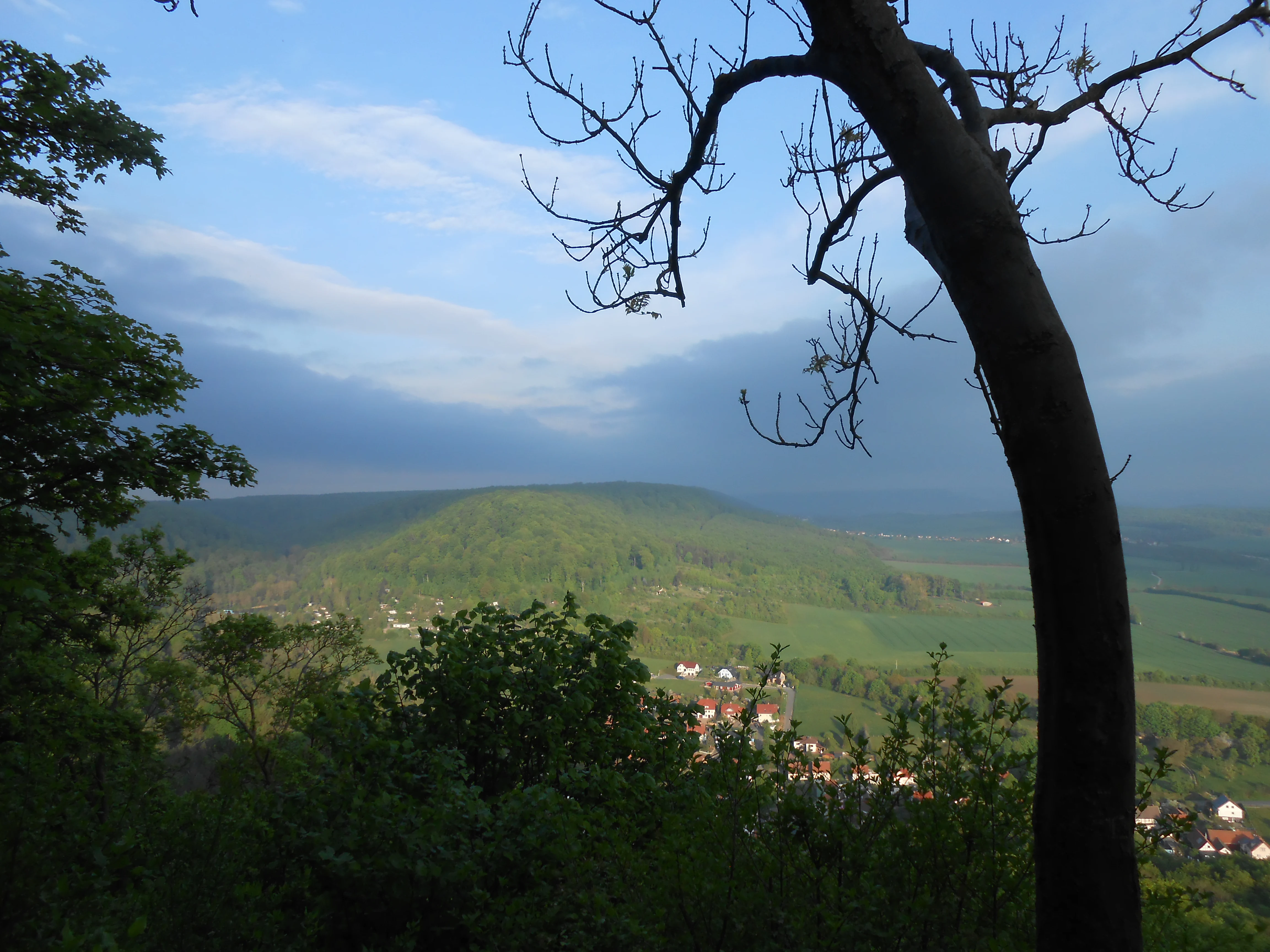
A wide view looking over a green forested valley and rolling hills in Germany, framed by tree branches in the foreground.
A scenic view over the hilly forest landscape of the Westliche Hainleite near Hainrode.

Westliche Hainleite history and protected-area timeline

The Westliche Hainleite nature reserve was formally designated in 2004, giving formal protection status to a section of the Hainleite that had long been recognized for its forest and slope habitats. Its establishment followed the broader European push to identify and protect representative natural and semi-natural landscapes under the Natura 2000 framework.

The reserve was created as part of a coordinated effort with the neighboring Wöbelsburg reserve. Together, the two areas underpin the larger 'Westliche Hainleite – Wöbelsburg' Fauna-Flora-Habitat and bird protection zone, a cross-boundary designation that integrates both sites into a single conservation planning unit. Burg Lohra, a castle ruin perched on one of the ridge spurs near the reserve, predates modern conservation by centuries and reflects the long-standing human presence in this part of the Hainleite, though the reserve itself is oriented around protecting natural rather than built heritage.

Westliche Hainleite landscape and geographic character

The landscape of Westliche Hainleite is shaped by the ridge-and-escarpment topography that defines the entire Hainleite range, but with distinctive features at its northwestern end. The reserve captures the part of the ridge that faces the Wippertal and transitions into the Dün hill country, which gives it a more open, broken profile than the central sections of the Hainleite.

The dominant landform is a steep escarpment edge that drops from the forested ridge plateau into the lower countryside. Along this edge, erosion has carved out the upper catchments of small streams that drain to the Wipper. Two of the most notable of these are the Renkgraben near Friedrichslohra and the Hainröder Bach near Hainrode, both of which begin as narrow gully-like incisions along the Hainleite's broken slope.

The skyline of the reserve is marked by a series of named summits. Der Berg, at roughly 451 meters, is the highest, followed by Steckenberg at about 424 meters and Kains at around 415 meters. A ridge spur at approximately 410 meters elevation carries the Burg Lohra, whose position on the edge of the protected area adds a strong vertical landmark to the skyline. Together, these features give the reserve a rolling, ridgeline-dominated character that feels distinctly Thuringian.

Westliche Hainleite ecosystems, habitats, and plant life

The ecological profile of Westliche Hainleite is built around the forest communities that occupy its slopes, plateaus, and valleys. The reserve protects extensive woodlands on the Hainleite ridge, with the escarpment edges and stream-cut gullies adding structural diversity that supports a wider range of habitats than the surrounding agricultural land.

Although the reserve lies in a part of Thuringia where farmland dominates the lowlands, the protected forests of the Hainleite function as an island of native woodland habitat. The combination of mature forest on the plateau, slope forests along the escarpment, and valley vegetation along the small tributaries of the Wipper creates a layered habitat mosaic typical of low mountain landscapes in central Germany.

The integration of the reserve into the larger 'Westliche Hainleite – Wöbelsburg' Fauna-Flora-Habitat and bird protection zone is a defining feature of its ecological role. By linking with the adjacent Wöbelsburg reserve, the area forms a continuous habitat corridor for forest interior species, cliff-nesting and slope-associated species, and the bird communities that the larger bird protection area is specifically designated to conserve.

Westliche Hainleite wildlife and species highlights

Because Westliche Hainleite is integrated into the 'Westliche Hainleite – Wöbelsburg' Fauna-Flora-Habitat and bird protection zone, the area is recognized for its value to bird species that depend on forest and slope habitats in the Hainleite. The combination of mature woodland on the ridge and structured, partially open escarpment edges makes the reserve suitable for typical central German forest and edge-of-forest bird assemblages.

The forested slopes and stream valleys also provide habitat for the broader community of woodland mammals, insects, and other fauna associated with low mountain forests in Thuringia. The exact local species mix is shaped by the transition between the Hainleite ridge and the Dün hills, which introduces habitat variety along the reserve's western boundary. While the publicly available documentation for the reserve emphasizes its Natura 2000 significance rather than a detailed species inventory, the reserve's protected status implies a focus on maintaining conditions for the characteristic forest and slope-associated wildlife of the region.

Westliche Hainleite conservation status and protection priorities

Westliche Hainleite holds a recognized conservation position through its formal designation as a Naturschutzgebiet, a status that gives it strong protection against activities that could alter its forest and slope habitats. The designation, granted in 2004, places the reserve among Thuringia's formally protected natural areas and links it administratively to the state's broader habitat protection system.

At the European level, the reserve's significance is amplified by its inclusion in the 'Westliche Hainleite – Wöbelsburg' Fauna-Flora-Habitat and bird protection area. This combined designation, which encompasses roughly 1,170 hectares, ties Westliche Hainleite to the European Natura 2000 network and gives it international recognition as habitat worthy of coordinated conservation management. The reserve is also classified under IUCN Category IV as a Habitat/Species Management Area, indicating a focus on active management of specific habitats and species alongside general protection.

The reserve's conservation value lies in its ability to act as a forested refuge along a ridge that is otherwise embedded in a heavily farmed landscape. By protecting the steep edges, the small tributary valleys, and the connections to forest of the wider Hainleite range, the reserve helps sustain ecological processes that would otherwise be lost to fragmentation in this part of central Germany.

Westliche Hainleite cultural meaning and human context

The cultural layer of Westliche Hainleite is modest but distinct, anchored primarily by the Burg Lohra, a medieval castle site that sits on a ridge spur at around 410 meters elevation near the boundary of the reserve. While the castle is not the focus of the nature reserve, its position within sight of the protected landscape ties the area to the longer human history of the Hainleite ridge, where hilltop fortifications have marked the landscape for centuries.

The reserve itself is otherwise a strongly nature-focused area, with its surrounding villages such as Großlohra, Friedrichslohra, and Hainrode reflecting the traditional pattern of small rural settlements embedded in the Hainleite landscape. These communities have long coexisted with the forests of the ridge, and the formal protection of Westliche Hainleite represents a more recent chapter in that long relationship between local land use and the natural features of the Hainleite.

Top sights and standout views in Westliche Hainleite

Westliche Hainleite stands out for the way it protects the northwestern end of the Hainleite ridge, including the transition zone between the main Hainleite range and the neighboring Dün hills. This transitional geography gives the reserve a distinct topographic identity within Thuringia's protected area system.

The reserve's integration with the larger Wöbelsburg reserve and the joint 'Westliche Hainleite – Wöbelsburg' Natura 2000 site is another defining highlight, creating one of the more coherent forest conservation complexes in the northern Thuringian hill country. Combined with the scenic ridgeline summits of Der Berg, Steckenberg, and Kains and the cultural landmark of Burg Lohra, the reserve offers a layered combination of natural and historical landscape features.

Best time to visit Westliche Hainleite

Westliche Hainleite is a forested low-mountain reserve, and its character shifts with the seasons in ways typical of central German hill country. Spring brings fresh leaf cover and active bird presence in the broadleaf and mixed forests along the ridge, while the small stream valleys that drain into the Wipper system become especially green and quiet.

Summer offers the densest forest experience, with full canopy cover along the plateau and shaded conditions along the escarpment edges. Autumn is arguably the most visually distinctive season, when the mixed forests of the Hainleite turn color and the views from ridges like Der Berg and Steckenberg open up over the surrounding landscape. Winter, when conditions allow, brings a quieter atmosphere, with frozen gullies and frost-edged slopes offering a more austere but striking view of the reserve's topography. The reserve's Natura 2000 status means visitors should plan around general good-practice nature reserve behavior rather than seasonal access restrictions.

Monthly climate preview

Track long-term temperature ranges and precipitation patterns across the year

Westliche Hainleite Climate and Monthly Weather Normals Overview

Representative point records for Westliche Hainleite outline measured monthly temperature swings from sub-zero winter minimums to warm summer maximums alongside consistent daily precipitation. Reviewing the complete twelve-month climatology data provides deeper context on long-term regional weather normals and seasonal averages.
Annual mean8 °C
-1 °C18 °C
Jan-1°
Feb-1°
Mar
Apr
May12°
Jun15°
Jul18°
Aug18°
Sep13°
Oct
Nov
Dec
Warmest month
July

17.7 °C

Coolest month
January

-1.4 °C

Wettest month
July

2.8 mm/day

Driest month
April

1.5 mm/day

Park location guide

Geography guide, regional context, and park location map for Westliche Hainleite

Westliche Hainleite park geography, regions, and map view in Germany

Understand where Westliche Hainleite sits in Germany through a broader geographic reading of the surrounding landscape, nearby location context, and its mapped position within the national park landscape.

How Westliche Hainleite fits into Germany

Germany is a federal republic in Western and Central Europe with a population of over 83 million across sixteen constituent states. It is Europe's largest economy by nominal GDP and a major global exporter and importer. The capital is Berlin, and the country borders Denmark, Poland, Czech Republic, Austria, Switzerland, France, Luxembourg, Belgium, and the Netherlands.

Wider geography shaping Westliche Hainleite in Germany

Germany is located in Western and Central Europe, spanning 357,022 km². It borders Denmark to the north, Poland and the Czech Republic to the east, Austria and Switzerland to the south, and France, Luxembourg, Belgium, and the Netherlands to the west. The country has coastlines on the Baltic Sea and North Sea to the north, with the Alps located in the southern region.

Map view of Westliche Hainleite

Use this park location map to pinpoint Westliche Hainleite in Germany, understand its exact geographic position, and read its mapped placement within the surrounding landscape more clearly.

Pigeon | © OpenStreetMap contributors

Location context for Westliche Hainleite

Thuringia

Visualizing the forested escarpments and ridge terrain of Thuringia

Westliche Hainleite Photos and Protected Area Landscapes

Photographic records capture the steep forested escarpments, narrow stream valleys, and ridge topography that define the protected natural character of Westliche Hainleite. Examining these visual habitats provides a clearer understanding of the protected slope ecosystems and rolling upland terrain across northern Thuringia.

A wide view looking over a green forested valley and rolling hills in Germany, framed by tree branches in the foreground.

Park atlas

Compare nearby low mountain ridges and connected forest reserves across Thuringia

Parks Near Westliche Hainleite and Surrounding Protected Landscapes

Browse other parks near Westliche Hainleite to uncover contiguous forest reserves and ridge habitats across northern Thuringia. Comparing adjacent protected areas reveals broader regional conservation patterns and connected slope ecosystems.
Nature reserveThuringia
About 2.9 km away#1 closest

East

Wöbelsburg Nature Reserve: Protected Plateau Landscapes and Geography in Thuringia, Germany

Mapped shell limestone escarpment and Iron Age hillfort site.

Wöbelsburg offers a focused look at the rugged Muschelkalk terrain characteristic of the northwestern Hainleite. As a protected nature reserve, the site features a prominent mountain spur that drops steeply toward the Wipper lowland, providing a clear example of geological undercutting and plateau formation in central Germany.

Area
0.659 km²
Established
1961
Relief
Upland
Water
Minor water
A soft watercolor illustration depicting layered green and pale pink rolling hills under a light sky.
Protected areaThuringia
About 7 km away#2 closest

West

Bleicheröder Berge: Geographic Profile and Protected Landscape Context in Thuringia

Mapping the forested ridges and Muschelkalk geology of the Thuringian region.

Investigate the Bleicheröder Berge as a vital protected area in Thuringia. This resource outlines the range's formation as a series of isolated hill remnants, its fossil-bearing limestone cliffs, and the botanical diversity characterizing its beech forests and rare orchid populations.

Area
16 km²
Relief
Mountain
Climate
Temperate
Access
Easy access
A horizontal watercolor painting showing rolling green and yellow hills with distant purple-toned forests against a white background.
Nature reserveThuringia
About 12 km away#3 closest

Southwest

Keulaer Wald Nature Reserve: Geographic Overview of the Dün Plateau Forest in Thuringia

Mapped beech-dominated plenterwald and limestone escarpment terrain

Located in northern Thuringia, Keulaer Wald is a designated nature reserve characterized by its continuous beech canopy on shell limestone bedrock. This site serves as a vital protected area within the regional forest belt, offering high-elevation viewpoints over the surrounding Eichsfeld Basin and the distant Harz mountain range.

Area
2.97 km²
Established
1961
Relief
Mountain
Climate
Temperate
A soft watercolor illustration showing a panoramic view of rolling green hills, trees, and soft-toned landscape features on a plain white background.
Nature reserveThuringia
About 18 km away#4 closest

Northeast

Rüdigsdorfer Schweiz: Protected Gypsum Karst Nature Reserve in Thuringia, Germany

A rare mapped landscape of karst sinkholes and dry valleys.

Rüdigsdorfer Schweiz stands as a critical protected area in Thuringia, known for its intact gypsum karst terrain. This landscape of gentle hills, earth collapses, and soluble rock formations serves as a vital ecological anchor in the Harz foothills. Explore the geography of this nature reserve to understand its layered protection and the distinctive geological history carved into its irregular surface.

Area
3.006 km²
Established
1997
IUCN
IV
A horizontal watercolor painting depicting rolling green hills and a dense forest canopy against a soft, light background.
Nature reserveThuringia
About 20 km away#5 closest

Northeast

Alter Stolberg Nature Reserve: Mapping the Karst Landscapes of the South Harz

A study of Zechstein geology and forested ridge geography in Thuringia

The Alter Stolberg serves as a primary example of karst topography within the South Harz Zechstein Belt, offering a compact and heavily wooded plateau landscape. This protected area includes distinct geological features like the Heimkehle gypsum cave and historical medieval ruins, illustrating the integration of natural processes and cultural history in central Germany. Explore the geographic boundaries and terrain characteristics that define this essential protected area.

Area
6.233 km²
Established
1961
IUCN
IV
Relief
Upland
Watercolor painting of a green, rolling valley with muted pastel tones.
Nature reserveThuringia
About 20 km away#6 closest

Southwest

Flachstal Nature Reserve: Geographic Profile and Protected Valley Landscapes in Thuringia

Ecologically rich calcareous dry valley and protected habitat mosaic

Flachstal represents a significant nature reserve within Thuringia, defined by its steep flanks of Muschelkalk limestone and centuries of traditional sheep grazing. This dry valley functions as both a hotspot for grassland species and a vital climate corridor for the surrounding plateau. The site offers an opportunity to study the intersection of geological history, fossil-rich streambeds, and modern conservation management within the Natura 2000 network.

Area
1.876 km²
Established
1999
IUCN
IV
Relief
Upland
Nature reserveThuringia
About 21 km away#7 closest

Northwest

Sülzensee, Mackenröder Wald: A Detailed Look at Thuringia's Protected Nature Reserve

Exploring the beech forest landscapes and stream-carved terrain of northern Thuringia.

Sülzensee, Mackenröder Wald is a protected nature reserve in northern Thuringia known for its expansive beech forests and diverse geological foundation. Spanning over 280 hectares, the area features undulating ridges, deep-cut stream valleys, and a unique position atop the Elbe-Weser watershed. This geography-focused overview details the reserve's status as a corridor for wildlife and its significant role in regional habitat conservation.

Area
2.802 km²
Established
2000
IUCN
IV
A watercolor painting showing a panorama of soft green rolling hills and meadows under a hazy, pale sky.
Nature reserveThuringia
About 23 km away#8 closest

Southwest

Grabsche Berge Nature Reserve: Thuringia Protected Hill and Cuesta Geography

Steppe-like terrain within the Thuringian Basin

The Grabsche Berge nature reserve encompasses a series of low hills forming a notable cuesta landscape in central Germany. This protected area provides a focal point for understanding dry grassland vegetation and geological transitions on the edge of the Unstrut floodplain, offering a distinct botanical and environmental study site in the heart of the Thuringian Basin.

Area
0.544 km²
Established
1996

Common questions about visiting, size, designation, and location context for Westliche Hainleite

Westliche Hainleite FAQs for park facts, access, geography, and protected area context

Find quick answers about Westliche Hainleite, including protected-area facts, park geography, trail and visitor context, and how the park fits into its surrounding country and regional landscape.
MoriAtlas Explorer

Continue Your Protected Areas Search Across the Global Atlas

Deepen your exploration by continuing the structured search for national parks and protected areas worldwide. Utilize the comprehensive filtering capabilities to compare different conservation landscapes and refine your understanding of global park geography. Discover more about the distribution and characteristics of protected natural areas.

Global natural geography