

Mori Atlas logo
Nature reserveWindelberg

A rare fragment of historic sandy heath and oak woodland within the Hümmling ridge landscape

Windelberg Nature Reserve: Protected Inland Dune and Heathland Geography in Lower Saxony

(Naturschutzgebiet Windelberg)

Windelberg encompasses a sixteen hectare nature reserve in the Emsland district of Lower Saxony, representing a distinct inland dune environment shaped by glaciation and historic land use. This protected area preserves complex ecological patterns, including dry heaths, juniper thickets, and relict oak woodlands, all thriving on acidic sandy soils. As an integral part of the European Natura 2000 network, it serves as a critical example of traditional landscape management within a managed military training zone.

inland dunessand heathjuniper heathacidic soilspodsolcoppice woodland

Windelberg

Nature reserve

Park overview

Structured park overview, official facts, and landscape profile for Windelberg

Windelberg park facts, protected area profile, and essential visitor context

Review the core facts for Windelberg, including designation, size, terrain, visitor scale, habitats, and operating context in one park-focused overview.

About Windelberg

Windelberg is a compact yet ecologically rich nature reserve in the Emsland district of Lower Saxony. Although modest in size, the protected area ranks as one of the more representative inland-dune heath sites in the region, preserving the ecological memory of the sandy Hümmling uplands through a layered mosaic of dry habitat types.

The reserve lies on a glacial ground-moraine ridge that has weathered into poor, sandy soils with classic podsol profiles developed under long continued heathland use. On this substrate the landscape dries out quickly, and over centuries a recognisably low-nutrient, open vegetation has established itself. Patches of inland dune support true sand heaths, dotted with juniper bushes and gorse, while older woodland stands survive as remnants of historic coppice management.

The protected area also holds considerable conservation significance at the European level. Windelberg's footprint is identical to the Habitats Directive site FFH 267 and therefore forms part of Germany's Natura 2000 contribution. This dual designation underscores the site's value both as a regional nature reserve under Lower Saxon law and as a habitat of community importance under EU nature policy.

Beyond its ecological character, Windelberg illustrates the long-running relationship between people and landscape in northwest Germany. Its heaths, juniper stands and oak-coppice woods collectively document how past land use, especially grazing and woodcutting, once shaped large parts of the Emsland. Today, sustaining those habitats depends on continued active management to prevent forest regrowth and to keep the sandy soils open for their specialised plant communities.

Quick facts and research context for Windelberg

Windelberg is a nature reserve (Naturschutzgebiet) of about sixteen hectares located northwest of the village of Börger in the Emsland district of Lower Saxony. It sits on the Hümmling, a glacial ground-moraine ridge, and its protected status is administered by the Emsland district under the oversight of the Lower Saxony Agency for Water Management, Coastal Defence, and Nature Conservation. The reserve's statistical code is NSG WE 028 and its elevation ranges from roughly thirty-two to thirty-six metres.

Protection and recognition

Examine official designation records and international conservation frameworks.

Windelberg Protection Status and Natura 2000 Recognition Details

Windelberg maintains documented protection status and official Natura 2000 recognition records within global databases. Conservation analysts evaluate these verified designation frameworks and administrative boundaries for environmental research.
Park context

Deeper park guide and search-rich context for Windelberg

Windelberg history, landscape, wildlife, and travel context

Explore Windelberg through its history, landscape character, ecosystems, wildlife, conservation priorities, cultural context, and seasonal travel timing in a structured park guide built for atlas discovery and search intent.

Why Windelberg stands out

Windelberg is especially known for its inland dune sand heaths and juniper-dominated vegetation growing on acidic sandy soils. The reserve preserves a textbook example of how traditional grazing and coppicing once shaped northwestern German landscapes, producing patches of dry heath with common heather, English and hairy gorse, crowberry, blueberry and lingonberry alongside old pedunculate-oak woodland. Its position entirely inside a Bundeswehr training ground has, paradoxically, kept much of the original vegetation intact.
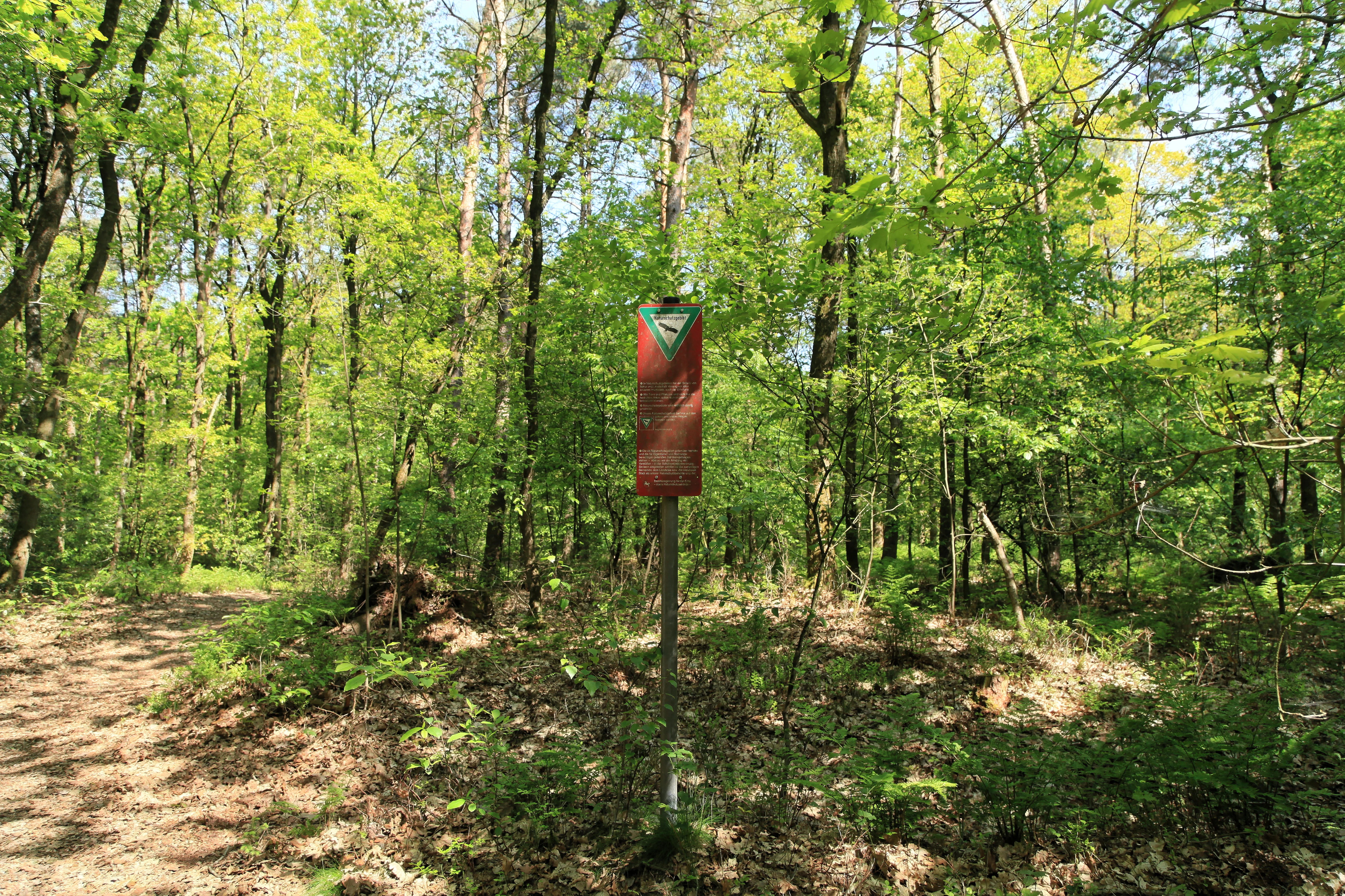
Wacholderhain and Windelberg Nature Reserve
Path to the prayer site at the edge of the Windelberg nature reserve in Borger.

Windelberg history and protected-area timeline

The Windelberg was first placed under protection on 18 January 1938, making it one of the older nature reserves in the Emsland region. The original protection order recognised the area's particular value as a habitat for sensitive species and as a landscape of distinctive character.

The current protection order dates from 30 January 2009 and was issued by the Emsland district authority. The 2009 decree reiterated the reserve's purpose, the long-term preservation, care, and development of the Windelberg as a refuge for protected animal and plant species, and as a landscape of notable rarity, character, diversity, and outstanding scenic qualities.

Alongside the renewed national designation, the Windelberg's surface has been integrated into the European Natura 2000 network through identification as FFH-Gebiet 267. This expansion of formal recognition reflects the continuing conservation priority placed on inland-dune heaths and the wider Hümmling landscape.

Windelberg landscape and geographic character

The reserve lies on a glacial ground-moraine ridge, the Hümmling, that rises only slightly above its surroundings. Elevations within the area sit roughly between thirty-two and thirty-six metres, but despite its modest relief the terrain is geologically distinctive, formed by sandy deposits left behind by former glaciation.

Across this low ridge, sandy inland dunes have developed into the most prominent geomorphological feature of the reserve. Their loose, nutrient-poor substrate has produced the conditions for an unusual inland dune landscape quite different from the wetter moors and river valleys otherwise common in the Emsland.

The relief is further shaped by vegetation patterns, with open dry heaths and dune ridges alternating against denser juniper thickets and oak woodland. Traversing the area, one moves repeatedly between exposed sandy patches and shaded, structurally richer woodland, giving the small reserve considerable scenic variety.

Windelberg ecosystems, habitats, and plant life

Ecologically, Windelberg is dominated by dry, sand-loving vegetation growing on acidic, nutrient-poor soils. Podsol profiles developed over long centuries of heath use characterise the substrate, while inland dunes provide the micro-topography that supports the most specialised plant communities.

Reserve management particularly promotes juniper-rich heaths and berry-rich open sand heath alongside relict oak woodland that originated under historic coppice management. The natural heritage of Windelberg therefore combines two complementary ecological processes: long-term cultural landscape formation and the persistence of dry, acidic habitats that today are scarce across much of northwest Germany.

Windelberg wildlife and species highlights

The Wikipedia source emphasises the reserve's plant communities rather than its fauna, and specific animal information is limited. The 2009 protection order, however, highlights the site's role as a refuge for protected animal and plant species, underscoring that the dry heath, juniper, and oak woodland mosaic supports distinctive fauna typical of northwest German inland dunes. Detailed species information was not provided in the source and has not been added here.

Windelberg conservation status and protection priorities

Windelberg's conservation importance rests on its position as a surviving fragment of an inland-dune sand-heath landscape on the Hümmling. Its small area holds disproportionately high habitat value because the nutrient-poor sandy soils and the long continuity of traditional land use have produced plant communities that are now uncommon across the Emsland and Lower Saxony more broadly.

The reserve also has notable European recognition. Its footprint coincides exactly with FFH-Gebiet 267, a site designated under the EU Habitats Directive, adding an EU-level layer of conservation responsibility to the national nature reserve designation. The conservation goal stated by the Emsland district explicitly stresses the preservation, care, and development of the area for protected species and as a landscape of exceptional quality.

A distinctive feature of Windelberg's conservation status is that the entire reserve sits within the Bundeswehr's Schiessplatz Meppen, the training area of the Technical Centre for Weapons and Ammunition. Restricting public access and conventional agricultural use has, over decades, sheltered the heath vegetation from the intensification that affected much of the surrounding countryside.

Windelberg cultural meaning and human context

Windelberg belongs to a class of Lower Saxon reserves whose ecological value is inseparable from centuries of traditional land use. The plant communities of the area bear the imprint of historic grazing practice and of coppice-style oak woodland management, in which trees were periodically cut back to ground level to provide firewood, browse, and timber. The reserve thus preserves a living record of how rural communities once shaped the sandy Hümmling landscape. No broader indigenous or regional cultural narrative is described in the source.

Top sights and standout views in Windelberg

Windelberg's highlights lie in the concentration of rare habitat types within a very small footprint. In one protected area visitors, in principle, can encounter dry inland-dune sand heaths, juniper thickets, calcareous-edge sand dry grassland species such as silvergrass, and old coppice-derived pedunculate oak woodland, all supported by podsol soils on the Hümmling ground-moraine ridge. The site's dual status as a Lower Saxon nature reserve and as FFH-Gebiet 267 underscores that what survives here is both regionally and European-level significant.

Best time to visit Windelberg

The source does not provide seasonality or visitor information for the Windelberg reserve, and no detailed seasonal guidance has been added.

Monthly climate preview

Track monthly averages and historical climate data for Windelberg in Lower Saxony

Windelberg Climate Normals, Long Term Temperature and Precipitation Patterns

Representative coordinate measurements reveal the long-term annual temperature and precipitation rhythm across Windelberg from 1991 to 2020. Examining the complete twelve-month climate profile provides detailed historical context regarding monthly temperature ranges and precipitation distributions.
Annual mean9 °C
2 °C18 °C
Jan
Feb
Mar
Apr
May13°
Jun16°
Jul18°
Aug18°
Sep14°
Oct10°
Nov
Dec
Warmest month
July

17.9 °C

Coolest month
January

1.5 °C

Wettest month
December

2.5 mm/day

Driest month
April

1.4 mm/day

Park location guide

Geography guide, regional context, and park location map for Windelberg

Windelberg park geography, regions, and map view in Germany

Understand where Windelberg sits in Germany through a broader geographic reading of the surrounding landscape, nearby location context, and its mapped position within the national park landscape.

How Windelberg fits into Germany

Germany is a federal republic in Western and Central Europe with a population of over 83 million across sixteen constituent states. It is Europe's largest economy by nominal GDP and a major global exporter and importer. The capital is Berlin, and the country borders Denmark, Poland, Czech Republic, Austria, Switzerland, France, Luxembourg, Belgium, and the Netherlands.

Wider geography shaping Windelberg in Germany

Germany is located in Western and Central Europe, spanning 357,022 km². It borders Denmark to the north, Poland and the Czech Republic to the east, Austria and Switzerland to the south, and France, Luxembourg, Belgium, and the Netherlands to the west. The country has coastlines on the Baltic Sea and North Sea to the north, with the Alps located in the southern region.

Map view of Windelberg

Use this park location map to pinpoint Windelberg in Germany, understand its exact geographic position, and read its mapped placement within the surrounding landscape more clearly.

Pigeon | © OpenStreetMap contributors

Location context for Windelberg

Lower Saxony
Recorded earthquake history

Explore Historical Earthquake Records Associated with Windelberg

Examine the archive of recorded seismic events documented near the Windelberg nature reserve in Lower Saxony. MoriAtlas provides a structured view of historical event parameters to support a deeper geographic understanding of the region.

Windelberg Earthquake History

Catalogued events

1 event

Strongest magnitude

Magnitude 3

Most recent event

Jul 2, 2006

This history includes earthquakes recorded inside the park or within 50 km of its borders

Explore detailed imagery of inland dunes, juniper thickets, and relict oak woodland across the reserve.

Windelberg Photos and Protected Landscape Scenery: Visualizing the Sand Heath Terrain

Visual documentation of Windelberg reveals the distinctive sandy topography and rare heath habitats preserved on the Hümmling ridge. Examining protected-area photography provides clear insight into the complex mosaic of dry heaths and woodland patches that define the local ecosystem.

Wacholderhain and Windelberg Nature Reserve

Park atlas

Compare nearby protected landscapes and sandy heath terrain across Lower Saxony

Explore Other Parks Near Windelberg And Protected Areas In The Surrounding Region

Visitors exploring Windelberg can continue browsing other protected areas sharing similar sandy terrain and rare dune habitats. Examining adjacent regional reserves provides broader context on northwestern German conservation landscapes.
Nature reserveLandkreis Emsland
About 9.6 km away#1 closest

West

Stillgewässer bei Kluse Nature Reserve: Geographic Overview and Protected Wetland Landscape

Mapping the distinctive aquatic corridors of Landkreis Emsland.

Stillgewässer bei Kluse features a compact yet diverse mosaic of standing water pools, floating bog fringes, and oak woodlands on sandy soils. As a protected nature reserve, it functions as a crucial ecological refuge within the Emsland agricultural landscape, offering a unique opportunity to study man-made wetlands that have evolved into mature natural habitats.

Area
0.521 km²
Established
2018
Relief
Lowland
Climate
Temperate
Protected landscapeEmsland
About 10 km away#2 closest

Southeast

Naturpark Hümmling: Geographic Overview of Emsland Protected Landscapes

Tracing glacial sand ridges, moorlands, and prehistoric cultural sites.

Naturpark Hümmling stands as a prominent protected landscape in Lower Saxony, characterized by its distinctive geest ridge, extensive raised bogs, and dense concentration of Neolithic stone monuments. The area map highlights a complex interplay of river valleys, heathland remnants, and historic cultural landmarks that define the geographical identity of this Emsland treasure.

Area
576 km²
Established
2015
Relief
Upland
Climate
Temperate
Nature reserveLower Saxony
About 21 km away#3 closest

South

Südtannenmoor Nature Reserve in Lower Saxony: An Atlas of Protected Bog Wetlands

Mapping rare heath pool ecosystems in the Emsland region

This nature reserve protects a fragile intersection of raised-bog remnants and shallow heath pools framed by coniferous forests. The site serves as a key reference for the restoration of specialized wetland vegetation in northwestern Germany, offering a clear view of how small-scale geography influences biodiversity in the Emsland landscape.

Area
0.049 km²
Established
2009
IUCN
IV
Relief
Lowland
Nature reserveLandkreis Leer
About 23 km away#4 closest

Northwest

Vellage Nature Reserve: Protected Wetland and Ems Floodplain Geography in Landkreis Leer

A study of floodplain terrain, wetland habitats, and dike-protected ecosystems.

Vellage is a significant nature reserve in the district of Leer, characterized by its cluster of inland freshwater ponds and deadwood-rich alder woodlands. Located within the Ems floodplain landscape, the reserve functions as a critical habitat mosaic for native amphibians and aquatic species, providing a clear example of protected lowland river geography in Lower Saxony.

Area
0.084 km²
Established
2018
Nature reserveLower Saxony
About 25 km away#5 closest

Southwest

Tausendschrittmoor Nature Reserve: Peatland Recovery and Raised Bog Geography in Emsland

A study in protected lowland peatland landscapes and recovery trajectories

Tausendschrittmoor serves as a vital nature reserve in Lower Saxony, protecting a rare pocket of raised bog habitat amidst an agricultural landscape. The reserve features two contrasting habitats: a rewetted western bog and an eastern bog woodland, each illustrating unique patterns of peatland regeneration on the North German Plain.

Area
0.655 km²
Established
1988
Nature reserveEmsland
About 25 km away#6 closest

South

Zitterteiche Nature Reserve in Emsland: Mapped Protected Landscapes and Geography

A study of lowland heath ponds and environmental history

Zitterteiche represents a specific, small-scale nature reserve in the Emsland of Germany, consisting of two shallow heath ponds defined by their surrounding agricultural plains. This detailed entry maps the physical terrain and ecological shift of these protected waters, offering a focused perspective on the regional geography and the historical trajectory of this unique, formally protected wetland area.

Area
0.029 km²
Established
1937
IUCN
IV
Relief
Lowland
Nature reserveLandkreis Cloppenburg
About 28 km away#7 closest

East

Talsperre Thülsfeld Nature Reserve: Geography and Protected Land Profile

Inland dune and wetland conservation in Landkreis Cloppenburg

Talsperre Thülsfeld functions as a protected nature reserve showcasing the traditional northwest German lowland landscape. The site contains a five kilometer long reservoir, expansive heathlands, and bog communities, offering a clear view of how glacial geography shapes modern conservation areas. Researchers and observers can examine the transition between dry sandy dunes and damp riverine floodplains within this concentrated ecological boundary.

Area
4.62 km²
Established
1957
Relief
Lowland
Climate
Temperate
Nature reserveEmsland
About 32 km away#8 closest

Southwest

Versener Heidesee Nature Reserve: Mapped Protected Areas in Emsland, Lower Saxony

Heathland habitats and aquatic ecosystems in the Bourtanger Moor region

Versener Heidesee represents a significant example of post-industrial landscape reclamation, where a motorway extraction site was transformed into a protected nature reserve. The site spans 40 hectares, featuring a 16-hectare lake and managed heathland that sustains rare algae species and diverse avian populations. Its location within the International Nature Park Bourtanger Moor-Bargerveen highlights the importance of small-scale, managed terrain for regional ecological health.

Area
0.4 km²
Established
2008
Relief
Lowland
Climate
Temperate

Common questions about visiting, size, designation, and location context for Windelberg

Windelberg FAQs for park facts, access, geography, and protected area context

Find quick answers about Windelberg, including protected-area facts, park geography, trail and visitor context, and how the park fits into its surrounding country and regional landscape.
MoriAtlas Explorer

Continue Your Protected Areas Search Across the Global Atlas

Deepen your exploration by continuing the structured search for national parks and protected areas worldwide. Utilize the comprehensive filtering capabilities to compare different conservation landscapes and refine your understanding of global park geography. Discover more about the distribution and characteristics of protected natural areas.

Global natural geography