


Mori Atlas logo
Nature reserveWisłok Środkowy z Dopływami

Mapping the freshwater habitats and riparian landscapes of the Wisłok and Stobnica river system

Wisłok Środkowy z Dopływami Nature Reserve and Protected River Corridor in Podkarpackie

Wisłok Środkowy z Dopływami represents a vital protected river corridor spanning the Jasielsko-Krośnieńska Basin and the outer Western Carpathians in southeastern Poland. This nature reserve protects a mosaic of floodplain forests, oak-hornbeam woodlands, and wet meadows that support rare freshwater fish and butterfly populations. The geographic scope encompasses the middle reaches of the Wisłok River and its Stobnica tributary, forming a continuous natural terrain that transitions across diverse foothills.

river valleyNatura 2000Habitats Directive sitefreshwater fishfloodplain forestoak-hornbeam forest
A flat, stylized vector illustration of a river flowing through a mountain valley with a waterfall in the distance under a pale sun.

Wisłok Środkowy z Dopływami

Nature reserve

Park overview

Structured park overview, official facts, and landscape profile for Wisłok Środkowy z Dopływami

Wisłok Środkowy z Dopływami park facts, protected area profile, and essential visitor context

Review the core facts for Wisłok Środkowy z Dopływami, including designation, size, terrain, visitor scale, habitats, and operating context in one park-focused overview.

About Wisłok Środkowy z Dopływami

Wisłok Środkowy z Dopływami is one of the Polish sites in the European Union's Natura 2000 ecological network, established under the EU Habitats Directive and identified by the code PLH180030. Its designation reflects the ecological value of a substantial length of the middle Wisłok River and one of its key tributaries, the Stobnica, in a region where the Wisłok flows through a sequence of foothills and submontane basins before eventually joining the San.

The site follows the natural geography of the valley rather than administrative boundaries. Its western anchor is the dam at Sieniawa in Krosno County, and its eastern anchor is the dam at Rzeszowie, the regional capital. Between these two points, the protected designation covers the river corridor itself and the habitats that depend on it. The Stobnica component runs from the bridge on the Domaradz to Golcowa road down to its confluence with the Wisłok, adding a tributary sub-unit to the main stretch.

In physical-geographical terms, the area lies within three mesoregions of the Western Carpathians. The western and central portions belong to the Jasielsko-Krośnieńska Basin, a depression carved by the Wisłok and its predecessors, while the eastern portions belong to the Strzyżowskie and Dynowskie Foothills, which form a transitional landscape between the basin and the higher Carpathian ranges to the south.

Ecologically, the site's value centers on the integrity of the river environment. The watercourse supports populations of protected freshwater fish, while the riparian zone retains patches of floodplain forest, oak-hornbeam forest, and wet meadows that match Annex I habitat types listed under the Habitats Directive. Together, these elements make the middle Wisłok valley a coherent ecological corridor rather than a fragmented patchwork of small habitat patches.

Quick facts and research context for Wisłok Środkowy z Dopływami

Wisłok Środkowy z Dopływami (Natura 2000 code PLH180030) is a Habitats Directive site in the Podkarpackie Voivodeship of southeastern Poland. It covers roughly 1,064 hectares along the middle Wisłok between the Sieniawa and Rzeszowie dams and along a section of the Stobnica tributary. The area spans three physical-geographical mesoregions: the Kotlina Jasielsko-Krośnieńska, Pogórze Strzyżowskie, and Pogórze Dynowskie. The site is recognized for its concentration of Annex II freshwater fish species and for supporting key Annex I habitat types associated with the river valley.

Protection and recognition

Documented terrestrial protection scope and official designation records

Wisłok Środkowy z Dopływami Protection Status and Natura 2000 Recognition

Wisłok Środkowy z Dopływami holds recorded terrestrial protection status backed by official Natura 2000 designation sources. Reviewing these documented recognition details provides clear insight into the conservation framework governing the protected area.
Park context

Deeper park guide and search-rich context for Wisłok Środkowy z Dopływami

Wisłok Środkowy z Dopływami history, landscape, wildlife, and travel context

Explore Wisłok Środkowy z Dopływami through its history, landscape character, ecosystems, wildlife, conservation priorities, cultural context, and seasonal travel timing in a structured park guide built for atlas discovery and search intent.

Why Wisłok Środkowy z Dopływami stands out

The site is best known as a riverine Natura 2000 area protecting one of the more biologically rich middle-course stretches of the Wisłok and its tributary system. Its defining feature is the combination of natural river habitats with floodplain forests and wet meadows, creating a corridor that supports protected fish in the water column and protected butterflies on the adjacent meadows. The area is also notable for hosting a set of Annex II fish species that depend on clean, well-oxygenated gravel sections of the river, including the brook lamprey, the Kessler's gudgeon, the white-finned gudgeon, the Peloponnese barbel, the asp, the bitterling, the bullhead, the spined loach, and the weatherfish. The wet meadows within the site add a complementary fauna of Annex II butterflies, tying the freshwater and grassland values of the valley together.
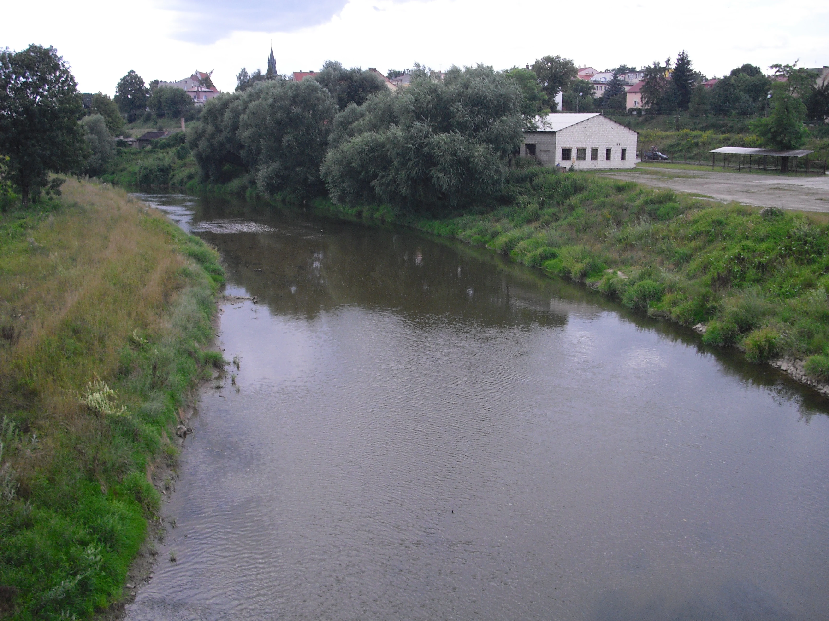
A wide, calm river flows through a green valley with a small white building and a town visible in the background under a cloudy sky.
The Wisłok River flowing through the town of Strzyżów.

Wisłok Środkowy z Dopływami history and protected-area timeline

Wisłok Środkowy z Dopływami was formally recognized as an area of Community importance under the EU Natura 2000 framework, with a recorded establishment year of 2011 in Polish conservation records. The designation built on earlier ecological surveys that had identified the middle Wisłok and its tributaries as hosting habitats and species listed in the annexes of the Habitats Directive.

The site was proposed for further protection as a Special Area of Conservation, or Specjalny obszar ochrony siedlisk, under Polish Natura 2000 procedures, extending the original Community-importance recognition into a fuller conservation regime. Documentation of the site was consolidated in a 2012 regional overview of Natura 2000 areas in Podkarpacie, edited by D. Rogała and A. Marcela for the Regional Directorate for Environmental Protection in Rzeszów, with the site described in the chapter authored by K. Kukuła and A. Bylak.

Wisłok Środkowy z Dopływami landscape and geographic character

The landscape of Wisłok Środkowy z Dopływami is shaped by the middle Wisłok valley as it crosses the transition between the Jasielsko-Krośnieńska Basin to the west and the Dynowskie and Strzyżowskie Foothills to the east. The terrain falls into a long, broadly north-trending corridor where the river has carved a comparatively gentle valley through soft Carpathian-flysch uplands.

The river itself forms the central thread of the area, while the Stobnica adds a tributary valley that joins the Wisłok from the south. Together, the two watercourses create a dendritic pattern of lowland and gentle slopes, dissected by side streams and small valleys that have historically supported riparian woodland, wet meadows, and pastoral land use.

In the eastern, footslope portion of the site, the terrain becomes more rolling as the foothills rise toward the higher Carpathian skyline. Forest cover on the slopes contrasts with open meadows and the braided mosaic of rural land along the river, producing the layered river-valley scenery visible from towns such as Strzyżów, which sits along the protected Wisłok corridor.

Wisłok Środkowy z Dopływami ecosystems, habitats, and plant life

The site's natural character is defined by the river and the habitats woven around it. The Wisłok and Stobnica channels provide the freshwater backbone of the area, with gravel and stony substrates, natural meanders, and side channels that retain much of their riverine dynamics.

Bordering the watercourse is a sequence of woodland types. Floodplain forests, known locally as łęgi, occupy the lowest, frequently flooded levels next to the river, while oak-hornbeam forests, or grądy, occupy slightly higher, better-drained terraces and footslopes. These two woodland types, both Annex I habitat categories under the Habitats Directive, frame the river with a continuous band of native deciduous cover.

Open habitats complement the forests. Fresh meadows, or łąki świeże, and moisture-variable meadows, called łąki zmiennowilgotne, occupy flatter areas along the valley where soil moisture and traditional management support herb-rich grassland. These wet meadows are particularly important as habitat for protected butterflies whose lifecycles depend on specific host plants and appropriate mowing or grazing regimes.

Wisłok Środkowy z Dopływami wildlife and species highlights

Wildlife interest in Wisłok Środkowy z Dopływami is dominated by freshwater fauna, with the river corridor sheltering nine fish species listed in Annex II of the Habitats Directive. These include the brook lamprey (Lampetra planeri), Kessler's gudgeon (Gobio kessleri), white-finned gudgeon (Gobio albipinatus), Peloponnese barbel (Barbus peloponessius), asp (Aspius aspius), bitterling (Rhodeus sericeus amarus), bullhead (Cottus gobio), spined loach (Cobitis taenia), and weatherfish (Misgurnus fossilis). Each of these has particular habitat requirements, ranging from clean gravel spawning areas for the lamprey and bullhead to slower margins and backwaters favored by the weatherfish and spined loach, and their joint presence is an indicator of a relatively well-functioning river system.

The wet meadows of the site add a distinctive invertebrate dimension. Three Annex II butterflies are recorded on the moisture-variable meadows: the scarce large blue (Phengaris teleius), the dusky large blue (Phengaris nausitous), and the large copper (Lycaena dispar). These species are tightly linked to specific plant communities and to traditional meadow management, giving the open habitats a conservation value that complements the riverine fauna.

Together, the freshwater fish and meadow butterflies form the two clearest faunal signals of the protected area, while the surrounding forests and hedgerows provide additional habitat for typical Carpathian foothills wildlife.

Wisłok Środkowy z Dopływami conservation status and protection priorities

Conservation importance at Wisłok Środkowy z Dopływami rests on its role within the EU's Natura 2000 network. As a designated obszar mający znaczenie dla Wspólnoty, or area of Community importance, the site contributes to the broader European effort to maintain habitats and species of Community interest. Its planned designation as a Special Area of Conservation would extend this recognition into a stronger management regime under Polish law.

The site's conservation value is closely tied to the integrity of the river environment and the surrounding habitat mosaic. The presence of nine Annex II freshwater fish species makes the middle Wisłok a priority for aquatic habitat protection, while the Annex I woodland and meadow habitats underpin the ecological coherence of the valley. Maintaining clean water, natural flow patterns, and continuity of forest and meadow habitat is central to keeping the site functioning as a coherent ecological corridor.

Regional conservation planning has integrated the site into Podkarpackie voivodeship-level Natura 2000 documentation, ensuring that the area is recognized in national inventories and protected-area databases maintained by the General Directorate for Environmental Protection in Poland.

Wisłok Środkowy z Dopływami cultural meaning and human context

The valley protected by the site is a long-settled rural landscape. Small towns and villages such as Sieniawa, Strzyżów, Domaradz, and Golcowa line the watersheds included in the designation, and the Wisłok has shaped the identity of the region through its role as a transport corridor, a source of hydropower at the dams that bound the site, and a focus of valley agriculture.

Traditional land use is reflected in the persistence of fresh meadows and moisture-variable meadows, which depend on mowing or grazing to retain their botanical character. This agricultural mosaic, combined with the small-scale villages and the wooded slopes of the foothills, gives the protected area a strongly human-shaped but ecologically productive character, characteristic of the outer Western Carpathians.

Top sights and standout views in Wisłok Środkowy z Dopływami

The site's strongest features are the length and continuity of the protected river corridor, the unusually rich set of Annex II freshwater fish in the Wisłok and Stobnica, and the pairing of river habitats with ecologically important meadows and forests. The combination of foothills and basin landscapes across three mesoregions gives the area a varied setting, while the planned Special Area of Conservation status signals long-term protection intent.

Key points of distinction include the joint presence of brook lamprey and weatherfish, rare fish indicators in Polish lowland and foothills rivers, and the occurrence of three protected butterfly species tied directly to the moisture-variable meadows of the valley floor.

Best time to visit Wisłok Środkowy z Dopływami

The middle Wisłok valley is most appealing in late spring and summer, when fresh and moisture-variable meadows are at their botanical peak and traditional management practices are visible across the valley floor. Late spring supports flowering meadows and active butterfly populations, while summer offers lush riparian woodland and stable river levels suitable for observing the freshwater environments that underpin the site's conservation value.

Autumn brings colorful deciduous canopy along the floodplain forests, and winter provides quieter conditions for understanding the overall valley structure. The transitional seasons of late spring and early autumn are generally the most informative times to experience the interplay of river, forest, and meadow that defines the area.

Monthly climate preview

Long-term representative temperature ranges and monthly precipitation patterns across the protected landscape

Wisłok Środkowy z Dopływami Climate Normals and Annual Weather Rhythms

Representative coordinates record sustained freezing winter averages alongside warm summer maximums and varied monthly precipitation totals. Detailed twelve-month climate tables provide comprehensive comparative metrics for the protected area.
Annual mean8 °C
-4 °C20 °C
Jan-4°
Feb-2°
Mar
Apr
May14°
Jun18°
Jul20°
Aug20°
Sep14°
Oct
Nov
Dec-2°
Warmest month
July

20 °C

Coolest month
January

-3.8 °C

Wettest month
July

3.1 mm/day

Driest month
January

1.3 mm/day

Park location guide

Geography guide, regional context, and park location map for Wisłok Środkowy z Dopływami

Wisłok Środkowy z Dopływami park geography, regions, and map view in Poland

Understand where Wisłok Środkowy z Dopływami sits in Poland through a broader geographic reading of the surrounding landscape, nearby location context, and its mapped position within the national park landscape.

How Wisłok Środkowy z Dopływami fits into Poland

Poland, officially the Republic of Poland, is a Central European country spanning from the Baltic Sea in the north to the Carpathian Mountains in the south. It borders Germany, Czech Republic, Slovakia, Ukraine, Belarus, Lithuania, and Kaliningrad Oblast. The country has a temperate climate, diverse landscapes, and is known for its rich history, cultural heritage, and strong economic position within the EU.

Wider geography shaping Wisłok Środkowy z Dopływami in Poland

Poland occupies 312,696 km2 in Central Europe, extending from the Baltic Sea coast in the north to the Sudetes and Carpathian Mountains in the south. It borders Germany to the west, Czech Republic and Slovakia to the south, Ukraine and Belarus to the east, and Lithuania and Kaliningrad Oblast to the northeast. The landscape includes lowland plains, uplands, and mountain ranges.

Map view of Wisłok Środkowy z Dopływami

Use this park location map to pinpoint Wisłok Środkowy z Dopływami in Poland, understand its exact geographic position, and read its mapped placement within the surrounding landscape more clearly.

Pigeon | © OpenStreetMap contributors

Location context for Wisłok Środkowy z Dopływami

Podkarpackie Voivodeship
Recorded earthquake history

Browse the Historical Earthquake Catalogue for Wisłok Środkowy z Dopływami

Explore recorded seismic events identified near the Wisłok Środkowy z Dopływami nature reserve. This catalogue from MoriAtlas offers a transparent look at historical epicentre data within the surrounding Podkarpackie landscape.

Wisłok Środkowy z Dopływami Earthquake History

Catalogued events

3 events

Strongest magnitude

Magnitude 4.2

Most recent event

Mar 1, 1993

This history includes earthquakes recorded inside the park or within 50 km of its borders

Visualizing river valleys, floodplain forests, and foothill habitats

Wisłok Środkowy z Dopływami Landscape and Protected Area Scenery

Visual records capture the distinctive river corridors, wet meadows, and Carpathian foothill terrain defining Wisłok Środkowy z Dopływami. Detailed photographic evidence illustrates the freshwater habitats and protected landscapes preserved across the region.

A wide, calm river flows through a green valley with a small white building and a town visible in the background under a cloudy sky.

Park atlas

Compare regional river valleys and connected conservation areas across the Western Carpathians

Explore Parks Near Wisłok Środkowy z Dopływami and Surrounding Protected Landscapes

Compare Wisłok Środkowy z Dopływami with adjacent river valley reserves and protected landscapes across the surrounding region. Broadening regional park discovery helps trace similar freshwater ecosystems and foothill terrains throughout southeastern Poland.
Protected areaPodkarpackie Voivodeship
0.1 km away#1 closest

Southwest

Łąki nad Wojkówką: Geographic Overview of Protected Grassland Habitats in Podkarpackie

Mapped protected areas and terrain across the Polish Carpathian foothills

Focusing on the convergence of xerothermic grasslands and fresh Arrhenatheretum meadows, Łąki nad Wojkówką represents a vital conservation site. This overview details its distribution across three enclaves, providing mapped context within the Wisłok River valley and its integration into the Czarnorzecko-Strzyżowski Landscape Park.

Area
0.096 km²
Established
2011
Relief
Upland
Scope
Terrestrial
Nature reservePodkarpackie Voivodeship
0.9 km away#2 closest

South

Ostoja Czarnorzecka Nature Reserve: Mapped Protected Landscapes in Podkarpackie Voivodeship

Carpathian foothills forest and cave habitat mapping

Ostoja Czarnorzecka is a protected nature reserve located in the Dynów Foothills of Poland. The area is defined by its dense Carpathian beech forests and a network of small, undisturbed caves. As a critical component of the regional conservation framework, it provides unique ecological benefits through its mature woodland cover and protected bat habitats found across the Sucha Góra and Królewska Góra ridges.

Area
19.466 km²
Established
2009
Relief
Upland
Scope
Terrestrial
Protected areaPodkarpackie Voivodeship
1.3 km away#3 closest

South

Rymanów Protected Area: Map and Landscape Overview in Podkarpackie Voivodeship

Forested foothill geography and Natura 2000 site boundaries

Located in the Podkarpackie Voivodeship, Rymanów is a 52-square-kilometer protected area defined by its rolling Bukowskie Foothills terrain. This site highlights the intersection of traditional architecture and subcarpathian forest, providing critical habitat within the larger Beskid Niski Protected Landscape Area. Examine the spatial relationship between its protected roosts and surrounding foraging zones.

Area
52.41 km²
Established
2009
Relief
Upland
Scope
Terrestrial
Nature reservePoland
1.6 km away#4 closest

South

Łąki w Komborni Nature Reserve: Geographic Insights and Protected Meadow Atlas

Subcarpathian grassland conservation in southeastern Poland

Examine the ecological landscape of Łąki w Komborni, a protected site in the Jasielsko-Krośnieńska Basin. This analysis focuses on the meadow habitat structure and its role as a representative Natura 2000 conservation area within the Polish landscape.

Area
0.131 km²
Established
2011
Relief
Lowland
Climate
Temperate
Protected areaPodkarpackie Voivodeship
3.5 km away#5 closest

South

Ostoja Jaśliska Protected Area: Carpathian Forest Landscapes and Ecological Geography

Exploring Natura 2000 boundaries in Podkarpackie Voivodeship

The Ostoja Jaśliska protected area sits within the Beskid Niski range, offering a deep look into Carpathian beech forest communities and rare peatland habitats. The region holds nine distinct nature reserves and provides essential connectivity for apex predator populations. This geographic profile details the terrain and environmental importance of this expansive protected polygon in southeastern Poland.

Area
292.521 km²
Established
2009
Relief
Mountain
Climate
Temperate
Protected areaPodkarpackie Voivodeship
4.2 km away#6 closest

Southeast

Patria nad Odrzechową: A Detailed Geographic Study of Protected Polish Carpathian Forest Lands

Deciduous forest mosaic in the Bukowskie Foothills

Patria nad Odrzechową is a key protected area in Poland, renowned for its concentration of European-priority beech and oak-hornbeam forests. The site provides a compact, representative look at the transitional forest ecology of the Subcarpathian region, preserved within the larger Beskid Niski landscape framework. Explore the specific habitat boundaries and terrain features that define this essential woodland corridor.

Area
5.73 km²
Established
2011
Relief
Upland
Scope
Terrestrial
Protected areaPodkarpackie Voivodeship
5.1 km away#7 closest

Southwest

Wisłoka z dopływami Protected Area: River Valley Landscape and Carpathian Foothills Atlas

Freshwater habitat mapping in southern Poland

Wisłoka z dopływami covers a long, ecologically rich segment of the Wisłoka river valley in the Carpathian foothills. This protected area connects diverse riparian, floodplain, and alluvial forests, serving as a critical habitat for six Annex II fish species and sixteen distinct riparian woodland types.

Area
26.51 km²
Established
2011
Relief
Mixed relief
Scope
Terrestrial
A watercolor illustration showing a landscape with a calm body of water, grassy banks, and rolling hills in the background.
Nature reservePodkarpackie Voivodeship
About 13 km away#8 closest

East

Mójka Nature Reserve: A Detailed Atlas View of Carpathian Foothill Protected Landscapes

Examining beech-fir forest and wetland habitats in Podkarpackie

Mójka Nature Reserve protects a 288 hectare forest environment within the Hyżnieńsko-Gwoźnicki Protected Landscape Area. This geographic entity showcases a mosaic of moist forest and aquatic habitats, documenting 340 vascular plant species and significant beaver-influenced hydrology in the rolling terrain of the Pogórze Dynowskie foothills.

Area
2.884 km²
Established
1997
Relief
Upland
Climate
Temperate

Common questions about visiting, size, designation, and location context for Wisłok Środkowy z Dopływami

Wisłok Środkowy z Dopływami FAQs for park facts, access, geography, and protected area context

Find quick answers about Wisłok Środkowy z Dopływami, including protected-area facts, park geography, trail and visitor context, and how the park fits into its surrounding country and regional landscape.
MoriAtlas Explorer

Continue Your Protected Areas Search Across the Global Atlas

Deepen your exploration by continuing the structured search for national parks and protected areas worldwide. Utilize the comprehensive filtering capabilities to compare different conservation landscapes and refine your understanding of global park geography. Discover more about the distribution and characteristics of protected natural areas.

Global natural geography