
Mori Atlas logo
Nature reserveWöbelsburg

Discover the shell limestone escarpment and prehistoric hillfort archaeology within the Hainleite plateau.

Wöbelsburg Nature Reserve: Mapped Protected Landscapes and Geological Terrain in Thuringia

Wöbelsburg serves as a compact nature reserve situated on the Hainleite plateau in Thuringia, Germany. This protected area preserves a dramatic mountain spur defined by its steep Muschelkalk escarpment rising above the Wipper river lowland. Beyond its geological significance, the site contains evidence of an Iron Age hillfort, illustrating the interplay between natural landforms and early human earthworks across this central German landscape.

nature reserveMuschelkalk escarpmentHainleite plateaushell limestonedry grasslandcliff habitat
A stylized flat-design illustration featuring a forested hill, a central waterfall cascading down a cliff face, and a river flowing through the foreground valley under a pale sun.

Wöbelsburg

Nature reserve

Park overview

Structured park overview, official facts, and landscape profile for Wöbelsburg Nature Reserve

Wöbelsburg Nature Reserve park facts, protected area profile, and essential visitor context

Review the core facts for Wöbelsburg Nature Reserve, including designation, size, terrain, visitor scale, habitats, and operating context in one park-focused overview.

About Wöbelsburg Nature Reserve

Wöbelsburg occupies one of the most distinctive spurs along the Hainleite ridge in northern Thuringia. The reserve protects a compact, elevated landform that projects northwestward from the Teilberg, with its three exposed flanks shaped by the erosional retreat of the softer layers beneath the Muschelkalk. This produces the steep, cliff-like faces that give the spur its fortress-like character and that made it attractive to prehistoric communities as a defensive position.

The landscape setting is transitional between the open plateau of the Hainleite and the deeper valley lowland of the Wipper. To the west and north, the slope drops sharply into the valley; to the southeast, the terrain merges more gradually with the surrounding plateau. The Hainröder Bach flows past the northwestern side of the reserve, and the L 2080 state road passes along its western edge, separating the spur visually from the adjoining countryside. Just to the north rises Schloss Hainrode, while the much larger Westliche Hainleite nature reserve lies to the west.

The protected area is small, but it concentrates a high density of features: scenic Muschelkalk cliffs, open plateau grassland and scrub, dry slopes favored by specialized flora, and an archaeological monument that has survived largely intact. This makes Wöbelsburg a representative example of a Hainleite spur reserve, where geological exposure, semi-open habitats, and prehistoric land use come together in a single, easily readable landform.

Quick facts and research context for Wöbelsburg Nature Reserve

Wöbelsburg is a protected nature reserve (NSG) in the Landkreis Nordhausen, Thuringia, in central Germany. It covers roughly 66 hectares on a 429.2 m spur that forms the northernmost extension of the Teilberg on the northwestern Hainleite plateau. The Muschelkalk escarpment falls steeply toward the Wipper valley to the west, north, and east, while the gentler slope descends toward the plateau interior. The reserve was placed under protection in 1961 and carries the official designation NSG-Nr. 005. The site is also documented in the World Database on Protected Areas.

Protection and recognition

Examine documented conservation standing and official database entries

Wöbelsburg Protection Status and International Recognition Records

Wöbelsburg protection status records compile verified administrative data, designation histories, and international recognition metrics where available. Structured protection profiles organize baseline management details and reference data for professional conservation analysis.

Protection details

WDPA ID
166344
Park context

Deeper park guide and search-rich context for Wöbelsburg Nature Reserve

Wöbelsburg Nature Reserve history, landscape, wildlife, and travel context

Explore Wöbelsburg Nature Reserve through its history, landscape character, ecosystems, wildlife, conservation priorities, cultural context, and seasonal travel timing in a structured park guide built for atlas discovery and search intent.

Why Wöbelsburg Nature Reserve stands out

Wöbelsburg is best known for its dramatic shell-limestone escarpment rising above the Wipper lowland, and for the well-preserved prehistoric hillfort enclosure that sits on the isolated spur. The combination of a clearly visible rampart and ditch, a near-triangular plateau protected by natural cliffs, and dating evidence from the late Hallstatt period gives the site a strong archaeological identity layered onto its geological setting.
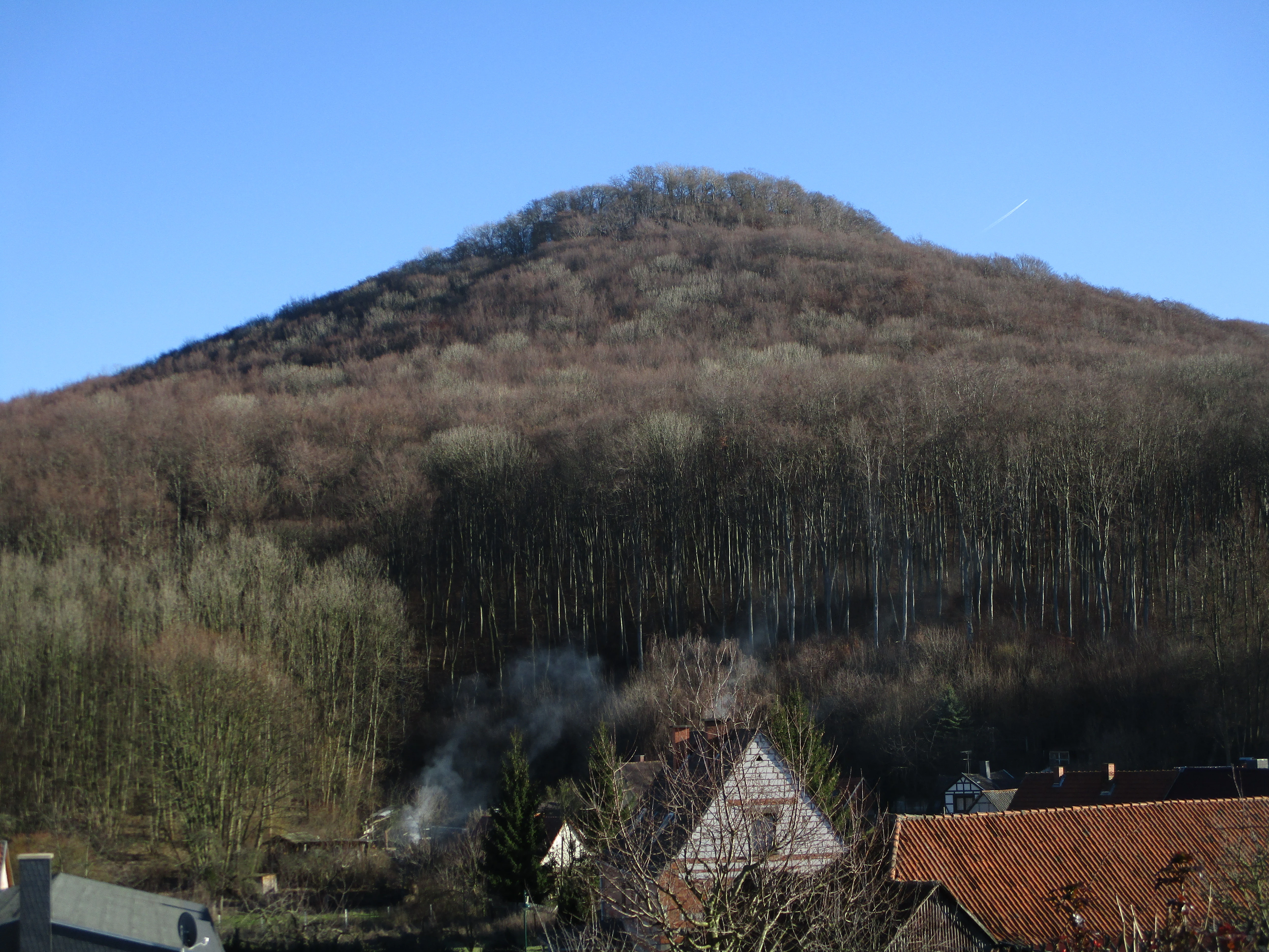
A conical hill covered in dense, leafless forest stands behind a village with red-tiled rooftops, under a clear blue sky.
The forested hill of Wöbelsburg rising above the village of Hainrode.

Wöbelsburg Nature Reserve history and protected-area timeline

The natural significance of the Wöbelsburg spur was formally recognized in 1961, when the area was placed under nature protection as NSG-Nr. 005. This made it one of the long-standing conservation designations in the Landkreis Nordhausen.

Long before any modern reserve, however, the spur served as a fortified site. The plateau is enclosed toward the mountain interior by an earthen rampart and ditch that remains clearly visible in the terrain, closing off the only non-cliff side of the spur. The interior of the enclosure measures roughly 140 by 300 meters. Archaeological finds date this hillfort to the late Hallstatt period of the early Iron Age, when communities across central Europe were establishing defended positions on prominent landforms.

The earliest written reference to the site appears in 1275, in the Latin phrasing 'a monte qui Wibelsberg nominatur', describing the mountain by the same name still in use today. This continuity of naming across centuries underlines how distinctive and recognizable the spur has long been within the Hainleite landscape.

Wöbelsburg Nature Reserve landscape and geographic character

The Wöbelsburg spur is fundamentally a product of layered sedimentary geology. The resistant Muschelkalk (shell limestone) cap forms the upper plateau and cliff edges, while the underlying, less resistant strata erode more quickly, undercutting the caprock and producing the steep slopes that bound the spur on three sides.

The highest point of the Wöbelsburg reaches about 429.2 meters, just below the Teilberg summit at 442.7 meters from which the spur extends northwestward. To the west, north, and east, the land falls in a sharp Muschelkalk escarpment toward the Wipper lowland, creating one of the more pronounced stage edges along the northwestern Hainleite plateau. Toward the southeast, the spur blends more smoothly into the broader plateau, which is also the direction from which access to the hillfort was historically controlled by the rampart and ditch.

The combination of steep rock faces, dry slope vegetation, plateau grassland, and the intervening valley of the Hainröder Bach gives the reserve a varied micro-topography despite its modest size.

Wöbelsburg Nature Reserve ecosystems, habitats, and plant life

The reserve protects the natural character of a classic Hainleite spur: shell-limestone cliffs, dry and semi-dry grassland on the slopes, scrubby transitions, and plateau-like vegetation on the flatter upper surfaces. These habitat types are typical of Muschelkalk escarpments in central Germany, where thin, calcium-rich soils support specialized plant communities adapted to dry, exposed conditions.

The juxtaposition of cliffs, slopes, and plateau creates a mosaic of microhabitats within a very small footprint. Steep south- and west-facing rock surfaces provide warm, dry conditions, while shaded cliff bases and small gullies offer cooler, more sheltered pockets. The plateau surface supports more continuous grassy and scrubby vegetation, and the transition to the surrounding agricultural and forested land occurs along the protected area's boundary.

Wöbelsburg Nature Reserve wildlife and species highlights

Wöbelsburg's cliff and dry-grassland habitats support the typical fauna associated with Muschelkalk escarpments along the Hainleite. Rock faces and rubble slopes provide nesting and shelter opportunities for cliff- and ground-nesting birds, while the open, flower-rich dry grasslands on the slopes and plateau attract insects, including bees, wasps, and butterflies that depend on warm, calcareous grassland conditions.

Small mammals, reptiles, and thermophilic invertebrates find refuge in the dry, stony slopes and along the rampart and ditch, where structural variation in the ground adds to the habitat diversity. Although the reserve is too small to host large mammal populations, its position at the edge of the Hainleite ridge means it functions as a stepping-stone within a broader mosaic of similar habitats extending along the plateau.

Wöbelsburg Nature Reserve conservation status and protection priorities

As a designated Naturschutzgebiet under German nature protection law, Wöbelsburg receives formal protection aimed at preserving its geological landform, its plant and animal communities, and its archaeological features. The reserve's small size makes it less about raw habitat area and more about protecting a representative and unusually well-defined example of a Muschelkalk spur ecosystem.

The conservation interest lies particularly in the dry and semi-dry grassland communities on the shell-limestone soils, the cliff and rock habitats, and the continuity of open land that has likely been maintained, in part, by the site's long history of use and its protected status. The reserve also contributes to the broader conservation network of the Hainleite, which includes the adjoining Westliche Hainleite protected area. Wöbelsburg is also recorded in the international World Database on Protected Areas, underlining its recognition beyond regional conservation listings.

Wöbelsburg Nature Reserve cultural meaning and human context

The Wöbelsburg hillfort is the key cultural layer of the site. The earthwork closure on the plateau side, combined with the natural protection of the cliffs, marks it as a deliberately chosen defensive location from the late Hallstatt period. Finds from the site place it within the wider network of late Hallstatt hilltop fortifications in central Germany, when promontory and spur sites were favored for settlement and control of movement through valleys and ridge lines. The 1275 written mention shows that the name itself has deep historical roots, predating modern conservation by several centuries.

Top sights and standout views in Wöbelsburg Nature Reserve

A compact nature reserve combining an Iron Age hillfort with a textbook Muschelkalk escarpment spur, on the edge of the Hainleite plateau overlooking the Wipper valley.

Best time to visit Wöbelsburg Nature Reserve

Spring and early summer are typically the most rewarding periods for visiting Wöbelsburg, when dry grassland vegetation on the slopes comes into flower and visibility along the escarpment edge is generally good. Late summer and early autumn bring drier, more open conditions on the plateau and clearer views across the Wipper valley, while the earthwork rampart and ditch remain visible year-round. Winter visits are possible but offer shorter daylight hours and reduced visibility into cliff details.


Monthly climate preview

Long-term temperature and precipitation averages for Wöbelsburg

Wöbelsburg Climate Normals and Measured Monthly Weather Patterns

Representative coordinate data records measured monthly temperature ranges and precipitation levels across Wöbelsburg. Detailed twelve-month climate profiles provide deeper analytical context for long-term regional weather tracking.
Annual mean8 °C
-1 °C18 °C
Jan-1°
Feb-1°
Mar
Apr
May12°
Jun15°
Jul18°
Aug18°
Sep13°
Oct
Nov
Dec
Warmest month
July

17.7 °C

Coolest month
January

-1.4 °C

Wettest month
July

2.8 mm/day

Driest month
April

1.5 mm/day

Park location guide

Geography guide, regional context, and park location map for Wöbelsburg Nature Reserve

Wöbelsburg Nature Reserve park geography, regions, and map view in Germany

Understand where Wöbelsburg Nature Reserve sits in Germany through a broader geographic reading of the surrounding landscape, nearby location context, and its mapped position within the national park landscape.

How Wöbelsburg Nature Reserve fits into Germany

Germany is a federal republic in Western and Central Europe with a population of over 83 million across sixteen constituent states. It is Europe's largest economy by nominal GDP and a major global exporter and importer. The capital is Berlin, and the country borders Denmark, Poland, Czech Republic, Austria, Switzerland, France, Luxembourg, Belgium, and the Netherlands.

Wider geography shaping Wöbelsburg Nature Reserve in Germany

Germany is located in Western and Central Europe, spanning 357,022 km². It borders Denmark to the north, Poland and the Czech Republic to the east, Austria and Switzerland to the south, and France, Luxembourg, Belgium, and the Netherlands to the west. The country has coastlines on the Baltic Sea and North Sea to the north, with the Alps located in the southern region.

Map view of Wöbelsburg Nature Reserve

Use this park location map to pinpoint Wöbelsburg Nature Reserve in Germany, understand its exact geographic position, and read its mapped placement within the surrounding landscape more clearly.

Pigeon | © OpenStreetMap contributors

Location context for Wöbelsburg Nature Reserve

Thuringia

Visual exploration of shell limestone cliffs, plateau habitats, and ridge terrain

Wöbelsburg Photos, Landscape Scenery, and Protected Area Views

Examine detailed visual records of Wöbelsburg, capturing the dramatic shell limestone escarpment and prehistoric earthworks across the Hainleite plateau. Photographic documentation reveals the rugged terrain, steep cliff habitats, and regional scenery that define this protected nature reserve.

A conical hill covered in dense, leafless forest stands behind a village with red-tiled rooftops, under a clear blue sky.

Park atlas

Compare adjacent plateau reserves and regional park geography

Exploring Parks Near Wöbelsburg and Surrounding Protected Landscapes

Browse protected areas near Wöbelsburg to examine similar limestone escarpments and plateau reserves across the region. Regional park comparison reveals connected geological formations and neighboring conservation landscapes.
Nature reserveThuringia
About 2.9 km away#1 closest

West

Westliche Hainleite Nature Reserve: Mapping the Protected Ridgeline Landscapes of Northern Thuringia

A study of forest escarpments, erosional valleys, and Natura 2000 ecological connectivity

Westliche Hainleite is a protected nature reserve in Thuringia defined by its steep ridgeline escarpments and transitionary geography between the Hainleite range and the Dün hills. This area preserves a mosaic of woodland, cliff, and slope habitats, maintaining essential ecological continuity across the northern German hill country. Its topography is characterized by deep erosional gullies and named summits like Der Berg, which create a distinctive vertical profile within the regional landscape.

Area
9.459 km²
Established
2004
IUCN
IV
A soft watercolor illustration depicting layered green and pale pink rolling hills under a light sky.
Protected areaThuringia
About 9.4 km away#2 closest

West

Bleicheröder Berge: Geographic Profile and Protected Landscape Context in Thuringia

Mapping the forested ridges and Muschelkalk geology of the Thuringian region.

Investigate the Bleicheröder Berge as a vital protected area in Thuringia. This resource outlines the range's formation as a series of isolated hill remnants, its fossil-bearing limestone cliffs, and the botanical diversity characterizing its beech forests and rare orchid populations.

Area
16 km²
Relief
Mountain
Climate
Temperate
Access
Easy access
A horizontal watercolor painting showing rolling green and yellow hills with distant purple-toned forests against a white background.
Nature reserveThuringia
About 15 km away#3 closest

Southwest

Keulaer Wald Nature Reserve: Geographic Overview of the Dün Plateau Forest in Thuringia

Mapped beech-dominated plenterwald and limestone escarpment terrain

Located in northern Thuringia, Keulaer Wald is a designated nature reserve characterized by its continuous beech canopy on shell limestone bedrock. This site serves as a vital protected area within the regional forest belt, offering high-elevation viewpoints over the surrounding Eichsfeld Basin and the distant Harz mountain range.

Area
2.97 km²
Established
1961
Relief
Mountain
Climate
Temperate
A soft watercolor illustration showing a panoramic view of rolling green hills, trees, and soft-toned landscape features on a plain white background.
Nature reserveThuringia
About 16 km away#4 closest

Northeast

Rüdigsdorfer Schweiz: Protected Gypsum Karst Nature Reserve in Thuringia, Germany

A rare mapped landscape of karst sinkholes and dry valleys.

Rüdigsdorfer Schweiz stands as a critical protected area in Thuringia, known for its intact gypsum karst terrain. This landscape of gentle hills, earth collapses, and soluble rock formations serves as a vital ecological anchor in the Harz foothills. Explore the geography of this nature reserve to understand its layered protection and the distinctive geological history carved into its irregular surface.

Area
3.006 km²
Established
1997
IUCN
IV
A horizontal watercolor painting depicting rolling green hills and a dense forest canopy against a soft, light background.
Nature reserveThuringia
About 18 km away#5 closest

Northeast

Alter Stolberg Nature Reserve: Mapping the Karst Landscapes of the South Harz

A study of Zechstein geology and forested ridge geography in Thuringia

The Alter Stolberg serves as a primary example of karst topography within the South Harz Zechstein Belt, offering a compact and heavily wooded plateau landscape. This protected area includes distinct geological features like the Heimkehle gypsum cave and historical medieval ruins, illustrating the integration of natural processes and cultural history in central Germany. Explore the geographic boundaries and terrain characteristics that define this essential protected area.

Area
6.233 km²
Established
1961
IUCN
IV
Relief
Upland
Nature reserveThuringia
About 22 km away#6 closest

Northwest

Sülzensee, Mackenröder Wald: A Detailed Look at Thuringia's Protected Nature Reserve

Exploring the beech forest landscapes and stream-carved terrain of northern Thuringia.

Sülzensee, Mackenröder Wald is a protected nature reserve in northern Thuringia known for its expansive beech forests and diverse geological foundation. Spanning over 280 hectares, the area features undulating ridges, deep-cut stream valleys, and a unique position atop the Elbe-Weser watershed. This geography-focused overview details the reserve's status as a corridor for wildlife and its significant role in regional habitat conservation.

Area
2.802 km²
Established
2000
IUCN
IV
Watercolor painting of a green, rolling valley with muted pastel tones.
Nature reserveThuringia
About 23 km away#7 closest

Southwest

Flachstal Nature Reserve: Geographic Profile and Protected Valley Landscapes in Thuringia

Ecologically rich calcareous dry valley and protected habitat mosaic

Flachstal represents a significant nature reserve within Thuringia, defined by its steep flanks of Muschelkalk limestone and centuries of traditional sheep grazing. This dry valley functions as both a hotspot for grassland species and a vital climate corridor for the surrounding plateau. The site offers an opportunity to study the intersection of geological history, fossil-rich streambeds, and modern conservation management within the Natura 2000 network.

Area
1.876 km²
Established
1999
IUCN
IV
Relief
Upland
Nature reserveThuringia
About 23 km away#8 closest

South

Großer Horn Nature Reserve: Protected Forest Geography and Mapped Landscape Context

A vital woodland reference site in the Thuringian Basin.

Großer Horn is a long-standing nature reserve located in northern Thuringia, notable for its strict totalreservat core and diverse forest composition. The protected area features an intricate soil mosaic of loess loam and limestone, supporting distinct oak and beech forest communities. This isolated habitat island provides essential insight into the ecological character of the subcontinental forest transition zone.

Area
0.159 km²
Established
1961
Relief
Upland
Climate
Temperate

Common questions about visiting, size, designation, and location context for Wöbelsburg Nature Reserve

Wöbelsburg Nature Reserve FAQs for park facts, access, geography, and protected area context

Find quick answers about Wöbelsburg Nature Reserve, including protected-area facts, park geography, trail and visitor context, and how the park fits into its surrounding country and regional landscape.
MoriAtlas Explorer

Continue Your Protected Areas Search Across the Global Atlas

Deepen your exploration by continuing the structured search for national parks and protected areas worldwide. Utilize the comprehensive filtering capabilities to compare different conservation landscapes and refine your understanding of global park geography. Discover more about the distribution and characteristics of protected natural areas.

Global natural geography