
Mori Atlas logo
Protected landscapeWolfschlugen

Examining the orchard meadows and mapped terrain of the Filder plateau

Wolfschlugen Protected Landscape and Regional Geography within Baden-Württemberg Germany

(Landschaftsschutzgebiet "Wolfschlugen")

The Wolfschlugen protected landscape comprises four distinct segments across the Filder plateau in Baden-Württemberg. This area serves as a vital example of traditional agricultural heritage, safeguarding extensive orchard meadows and grassland habitats within the broader Swabian landscape. MoriAtlas provides a detailed geographic view of these protected zones, highlighting the mosaic of open fields and local wetland features that define this representative region.

landscape protection areaStreuobstwiesenorchard meadowsmeadowstraditional farmlandFilder plateau
A flat, stylized digital illustration of a mountain valley scene featuring a waterfall cascading down a rocky cliff, a meandering river through a forest, and scattered clouds in the sky.

Wolfschlugen

Protected landscape

Park overview

Structured park overview, official facts, and landscape profile for Wolfschlugen Landscape Protection Area

Wolfschlugen Landscape Protection Area park facts, protected area profile, and essential visitor context

Review the core facts for Wolfschlugen Landscape Protection Area, including designation, size, terrain, visitor scale, habitats, and operating context in one park-focused overview.

About Wolfschlugen Landscape Protection Area

Wolfschlugen is a small but ecologically and culturally meaningful protected landscape on the Filder plateau, just south of Stuttgart in Baden-Württemberg. Although modest in size, the area captures an essential piece of the regional landscape character: traditional Swabian farmland shaped by centuries of meadow cultivation and scattered fruit-tree orchards. By grouping four separate parcels of land around the municipality of Wolfschlugen under a single landscape protection designation, the area links local ecological, agricultural, and recreational interests into one coherent conservation framework.

The protection area belongs to the natural region of the Filder, a relatively flat and fertile highland that has long supported mixed agricultural use. Within Baden-Württemberg's wider system of Landschaftsschutzgebiete, Wolfschlugen functions as a local-scale safeguard for traditional land use rather than a large wilderness reserve. Its focus is to keep the rural mosaic of meadows, old orchard stands, and seminatural elements intact, while also ensuring that residents of the densely settled Stuttgart region retain access to nearby open countryside for recreation.

The ordinance establishing Wolfschlugen came from the Landratsamt Esslingen and included the simultaneous repeal of an earlier 1981 protection order for the adjacent "Hattenloch-Starke Äcker" area, consolidating landscape protection in this part of the district into a single coherent designation. Today the area is administered by the district office of Esslingen and recorded in the state's Schutzgebietsverzeichnis, where it remains part of a wider network of landscape protection areas across the district.

Quick facts and research context for Wolfschlugen Landscape Protection Area

Wolfschlugen is a category V protected landscape (Protected Landscape/Seascape) under the IUCN system, located near the town of Wolfschlugen in the district of Esslingen in Baden-Württemberg, Germany. It sits in natural region 106, the Filder, within the major natural unit known as the Schwäbisches Keuper-Lias-Land. The protected area comprises four separate sections totaling roughly 51 hectares, established by ordinance of the Landratsamt Esslingen on 18 April 1985. Its official identification number is 1.16.067 and its WDPA ID is 325933. Management falls under the Landratsamt Esslingen, and the area is documented in the Schutzgebietsverzeichnis of the Landesanstalt für Umwelt Baden-Württemberg.

Protection and recognition

Examine the documented conservation framework and regulatory history for Wolfschlugen.

Wolfschlugen Protection Status and Official Designation Records

Wolfschlugen protection status records aggregate official administrative boundaries and baseline designation details for analytical review. Conservation framework documentation details regulatory oversight, management parameters, and verified international registry entries.

Protection details

WDPA ID
325933
Park context

Deeper park guide and search-rich context for Wolfschlugen Landscape Protection Area

Wolfschlugen Landscape Protection Area history, landscape, wildlife, and travel context

Explore Wolfschlugen Landscape Protection Area through its history, landscape character, ecosystems, wildlife, conservation priorities, cultural context, and seasonal travel timing in a structured park guide built for atlas discovery and search intent.

Why Wolfschlugen Landscape Protection Area stands out

Wolfschlugen is best known for protecting traditional Swabian Streuobstwiesen, the open meadows planted with scattered fruit trees that are emblematic of the regional agricultural heritage. The protected status safeguards these orchard meadows, the surrounding grasslands, and the recreational value they provide for the local population on the Filder plateau.
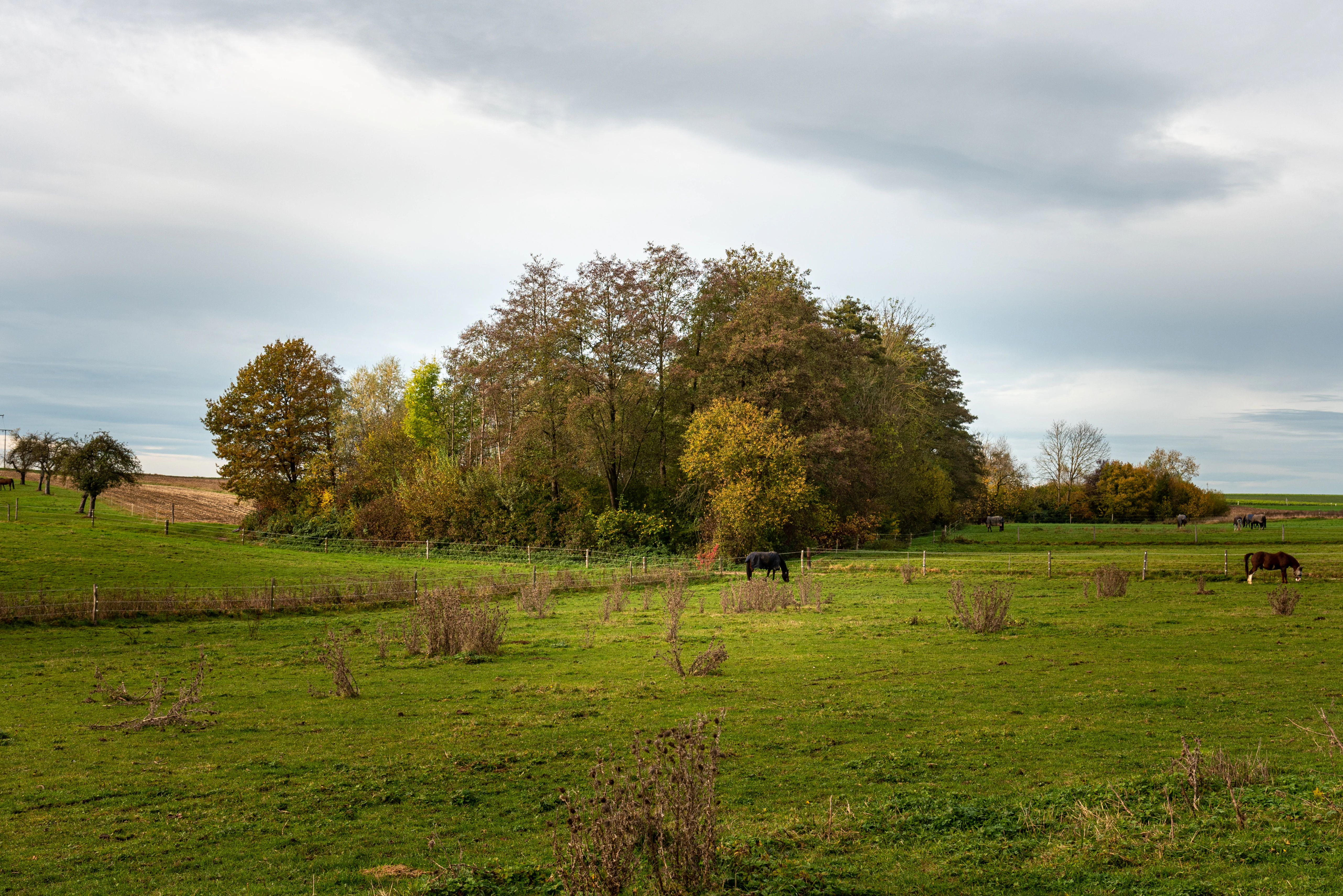
A wide view of a green meadow in Wolfschlugen with a cluster of autumn-colored trees in the center and horses grazing in the pasture under a cloudy sky.
The Bitzlenbach wetland area in Wolfschlugen, characterized by meadows and a central tree cluster, under a cloudy autumn sky.

Wolfschlugen Landscape Protection Area history and protected-area timeline

The protection of Wolfschlugen as a Landschaftsschutzgebiet was formalized on 18 April 1985 through an ordinance issued by the Landratsamt Esslingen. The designation brought together four distinct land parcels around the community of Wolfschlugen into a unified protection framework, covering approximately 51 hectares in the Filder natural region of southern Baden-Württemberg. At the same time, an earlier 1981 ordinance for the neighboring "Hattenloch-Starke Äcker" landscape protection area was rescinded, consolidating the broader landscape protection strategy for this part of the district.

The 1985 ordinance was issued during a period when Baden-Württemberg was actively expanding its catalogue of protected landscapes, particularly to preserve traditional agricultural landscapes such as the Streuobstwiesen that characterize much of the Swabian region. Wolfschlugen was documented in the 1985 publication "Landschaftsschutzgebiete im Kreis Esslingen" by the Landesanstalt für Umweltschutz Baden-Württemberg, placing it within the early wave of systematic landscape protection in the Esslingen district.

Wolfschlugen Landscape Protection Area landscape and geographic character

Wolfschlugen lies on the Filder plateau, a gently rolling highland south of Stuttgart characterized by flat to slightly undulating terrain and fertile agricultural soils derived from underlying Keuper and Lias sedimentary layers. The protected landscape reflects this setting through open meadows, field edges, and traditional orchard stands rather than dramatic topography. Within the broader context of the Schwäbisches Keuper-Lias-Land, the area represents a transition zone where the open Filder plains meet adjacent wooded ridges and small valleys.

The four protected sections are distributed around the settled area of Wolfschlugen, creating a mosaic of open farmland and grassland rather than a single contiguous block. A particular landscape feature referenced in the area is the Feuchtgebiet am Bitzlenbach, a wetland feature near the Bitzlenbach stream, which is designated as a natural monument (Naturdenkmal) within or near the protected area. This combination of dry meadow habitats alongside small wetland pockets gives the protected area a varied micro-geography despite its modest overall size.

Wolfschlugen Landscape Protection Area ecosystems, habitats, and plant life

Ecologically, Wolfschlugen centers on traditional, extensively used grassland habitats, with a particular emphasis on Streuobstwiesen, the species-rich meadows interspersed with old fruit trees. These orchard meadows are a hallmark of the Swabian agricultural landscape and serve as valuable secondary habitats that combine open ground for wildflowers and insects with structural diversity from mature trees. The mix of grass, herb, and tree layers supports a wide range of pollinators, birds, and other small fauna typical of traditional Central European farmland.

The inclusion of a wetland feature at the Bitzlenbach adds a contrasting habitat element, supporting moisture-loving plant communities and the invertebrates and amphibians associated with small wet depressions and stream margins. Together, the meadow and wetland components create a small but ecologically varied mosaic where dry grassland, orchard trees, and damp habitat coexist within a tightly bounded rural setting.

Wolfschlugen Landscape Protection Area wildlife and species highlights

The wildlife value of Wolfschlugen is closely tied to the traditional orchard meadow habitats it protects. Streuobstwiesen are well known in southern Germany for supporting cavity-nesting birds, a variety of bat species, butterflies and other pollinators associated with flower-rich grasslands, and small mammals that thrive at the interface of open meadow and scattered tree cover. The inclusion of a wetland area around the Bitzlenbach further extends the habitat range, providing conditions for amphibians, dragonflies, and moisture-dependent invertebrates that would not otherwise occur in a purely dry meadow landscape.

Because the protection area is small and embedded in a densely settled agricultural region, its role is primarily to maintain and connect existing habitat pockets rather than to host large or wide-ranging species. The conservation value lies in the continuity and quality of habitat that such small protected areas provide in an intensively used regional landscape.

Wolfschlugen Landscape Protection Area conservation status and protection priorities

As a category V protected landscape under the IUCN system, Wolfschlugen carries an IUCN classification that emphasizes the protection of long-lived landscapes and seascapes shaped by interaction with people. Within Baden-Württemberg's conservation framework, the area is part of a dense network of Landschaftsschutzgebiete in the district of Esslingen, each contributing to the preservation of regionally characteristic cultural landscapes.

The conservation purpose explicitly targets the maintenance of meadows and traditional orchard stands as natural habitats for plants and animals, while also safeguarding the area as a recreational space for the public. Protection measures address specific local pressures, including the prevention of further encroachment by small buildings and enclosures, ensuring that the open and traditional character of the protected sections around Wolfschlugen remains intact over time.

Wolfschlugen Landscape Protection Area cultural meaning and human context

Wolfschlugen reflects the cultural landscape tradition of the Filder plateau and the wider Schwäbisches Keuper-Lias-Land. Streuobstwiesen are deeply tied to the agricultural and rural identity of Swabia, historically supplying fruit for local households and small-scale processing, while also structuring the appearance of the countryside with their characteristic scattered, old-growth trees. Maintained as living heritage rather than purely ecological habitat, these orchard meadows embody a centuries-old relationship between farming communities and their land.

The choice to protect the landscape around Wolfschlugen also reflects the values of a densely populated region where nearby open countryside carries strong meaning for residents. By preventing fragmentation from small-scale construction and enclosures, the protection area helps preserve a sense of traditional Swabian rural character immediately adjacent to the urban edge of the Stuttgart metropolitan area.

Top sights and standout views in Wolfschlugen Landscape Protection Area

Wolfschlugen stands out as a compact but representative example of how Swabian Streuobstwiesen and traditional meadows are protected at the local level in Baden-Württemberg. Its four-part structure demonstrates how a small network of parcels around a single community can be assembled into a coherent protection area, while the inclusion of the Bitzlenbach wetland feature adds ecological variety to an otherwise meadow-dominated setting.

Best time to visit Wolfschlugen Landscape Protection Area

The most rewarding times to experience the Wolfschlugen landscape are spring and early summer, when wildflowers in the meadows are at their peak and fruit trees in the Streuobstwiesen are in blossom, and late summer to early autumn, when orchard meadows traditionally come alive with harvest activity and grasses attain their full golden character. Late spring is especially good for observing pollinators and birdlife in the orchard meadows, while the cooler months offer quieter, more open views across the Filder plateau landscape.

Monthly climate preview

Measured annual temperature and precipitation rhythms across twelve months

Wolfschlugen Climate Normals and Long Term Weather by Month

Long term climate data for Wolfschlugen records the annual progression of average temperatures and monthly precipitation patterns from representative coordinates. Reviewing the complete twelve month profile provides detailed context on recorded thermal ranges and precipitation amounts.
Annual mean8 °C
-1 °C18 °C
Jan-1°
Feb
Mar
Apr
May13°
Jun16°
Jul18°
Aug18°
Sep14°
Oct
Nov
Dec
Warmest month
July

18.2 °C

Coolest month
January

-1.1 °C

Wettest month
July

3.2 mm/day

Driest month
February

1.7 mm/day

Park location guide

Geography guide, regional context, and park location map for Wolfschlugen Landscape Protection Area

Wolfschlugen Landscape Protection Area park geography, regions, and map view in Germany

Understand where Wolfschlugen Landscape Protection Area sits in Germany through a broader geographic reading of the surrounding landscape, nearby location context, and its mapped position within the national park landscape.

How Wolfschlugen Landscape Protection Area fits into Germany

Germany is a federal republic in Western and Central Europe with a population of over 83 million across sixteen constituent states. It is Europe's largest economy by nominal GDP and a major global exporter and importer. The capital is Berlin, and the country borders Denmark, Poland, Czech Republic, Austria, Switzerland, France, Luxembourg, Belgium, and the Netherlands.

Wider geography shaping Wolfschlugen Landscape Protection Area in Germany

Germany is located in Western and Central Europe, spanning 357,022 km². It borders Denmark to the north, Poland and the Czech Republic to the east, Austria and Switzerland to the south, and France, Luxembourg, Belgium, and the Netherlands to the west. The country has coastlines on the Baltic Sea and North Sea to the north, with the Alps located in the southern region.

Map view of Wolfschlugen Landscape Protection Area

Use this park location map to pinpoint Wolfschlugen Landscape Protection Area in Germany, understand its exact geographic position, and read its mapped placement within the surrounding landscape more clearly.

Pigeon | © OpenStreetMap contributors

Location context for Wolfschlugen Landscape Protection Area

Baden-Württemberg

Visualizing the terrain, scattered fruit trees, and habitat mosaics of the Filder plateau protected area

Wolfschlugen Landscape Photos: Exploring Protected Scenery and Traditional Orchard Meadows

Examine detailed Wolfschlugen photos to understand the flat agricultural terrain and traditional Streuobstwiesen meadows that define the local protected area. Visual records reveal the open meadow network, field edges, and wetland micro-geography across the surrounding regional landscape.

A wide view of a green meadow in Wolfschlugen with a cluster of autumn-colored trees in the center and horses grazing in the pasture under a cloudy sky.

Park atlas

Compare regional protected areas and surrounding Filder plateau terrain

Explore Parks Near Wolfschlugen and Adjacent Protected Landscapes

Browse other parks near Wolfschlugen to examine similar orchard meadows and protected rural landscapes in southern Germany. This regional comparison expands protected area discovery across adjacent terrain and local conservation zones.
A minimalist watercolor painting depicting a soft-focus landscape with rolling hills, distant ridgelines, and scattered trees across a meadow, rendered in muted greens, purples, and pinks on a white background.
Protected landscapeBaden-Württemberg
About 5.8 km away#1 closest

West

Ohmden-Holzmaden Protected Landscape: Swabian Alb Foothill Mapping

A diverse mosaic of traditional orchards and stream valleys

Ohmden-Holzmaden encompasses a vital protected landscape in the Esslingen district, defined by the Trinkbach, Seebach, and Aubach valleys. This geography of traditional orchards, meadows, and hedgerows maintains an open, structured rural habitat that serves as a critical refuge within the broader Swabian Alb foothill region of Germany.

Area
3.111 km²
Established
1993
IUCN
V
Relief
Upland
A soft watercolor illustration showing a rolling landscape with gentle hills, grassy fields, and tree lines in shades of green, yellow, and faint pink.
Protected landscapeBaden-Württemberg
About 6.4 km away#2 closest

South

Oberes Filstal-Gemeinde Gruibingen: Protected Landscape and Regional Geography

Swabian Alb terrain within the Göppingen district

Oberes Filstal-Gemeinde Gruibingen forms a crucial ecological envelope around specialized nature reserves on the Swabian Alb. The landscape is defined by its characteristic kuppen hill-and-basin topography, featuring ridge slopes, stream-cut valleys, and traditional agricultural land that supports high floristic diversity within the Baden-Württemberg region.

Area
1.71 km²
Established
1984
IUCN
V
Protected landscapeBaden-Württemberg
About 6.5 km away#3 closest

Southwest

Weilheim an der Teck auf Gemarkungen Weilheim und Hepsisau Protected Landscape Atlas

Volcanic hill geography in the Baden-Württemberg region

This protected area safeguards a richly structured landscape where rolling foothills meet the steep escarpments of the Swabian Alb. Centered on the volcanic peaks of Limburg and Egelsberg, the region maintains a vital balance between forest corridors and open agricultural plains within the district of Esslingen.

Area
13.615 km²
Established
1979
IUCN
V
Protected landscapeBaden-Württemberg
About 8.8 km away#4 closest

West

Notzingen Protected Landscape: Mapping the Voralb Foothills and Swabian Alb Terrain

Regional protected area analysis in Landkreis Esslingen

Notzingen represents a coherent protected landscape composed of three parcels near the Swabian Alb foothills. The area is defined by a delicate intersection of stream-side riparian habitats and traditional Streuobstwiesen orchard meadows. This atlas-focused entry provides spatial context for understanding how these protected lands maintain the character of the southern German countryside.

Area
3.15 km²
Established
1989
IUCN
V
Relief
Upland
A watercolor painting showing a soft green landscape with rolling hills, a distant mountain range, and flowering trees.
Protected landscapeBaden-Württemberg
About 9.4 km away#5 closest

North

Nassachtal Protected Landscape: Geographic Overview and Mapped Terrain in Baden-Württemberg

Conservation geography of the Nassach stream catchment area.

Covering the full extent of the Nassach valley in southwestern Germany, this protected landscape serves as a critical ecological link between forest and agricultural zones. The terrain encompasses a typical Swabian hill country profile with incised stream valleys and wooded ridges, securing natural continuity across the Schurwald and Welzheimer Wald regions.

Area
21.666 km²
Established
1982
IUCN
V
Relief
Upland
A soft watercolor painting depicting rolling green hills and meadows against a white background.
Protected landscapeBaden-Württemberg
About 9.8 km away#6 closest

South

Neidlinger Tal Protected Landscape: Regional Geography and Mapped Boundaries

A study of the Swabian Alb and Alb foreland transition terrain

The Neidlinger Tal protected landscape represents a vital intersection of natural regions in Baden-Württemberg. Its boundaries encompass a mosaic of forest and farmland, providing a comprehensive look at how historical land use patterns coexist with modern conservation efforts within the Swabian Alb, including various bird and habitat protection designations.

Area
10.959 km²
Established
1975
IUCN
V
Relief
Upland
Protected landscapeBaden-Württemberg
About 10 km away#7 closest

South

Oberes Filstal-Gemeinde Mühlhausen im Täle: Protected Landscape Geography and Map Data

Swabian Alb regional landscape and habitat mosaic

Analyze the protected landscape of Oberes Filstal-Gemeinde Mühlhausen im Täle through its unique physical terrain and ecological structure. This area in the Göppingen district features a complex interplay of river valleys and plateau uplands, creating a habitat corridor that links the Fils valley with the wider Swabian Alb, supporting diverse flora and traditional land-use patterns.

Area
5.13 km²
Established
1983
IUCN
V
Watercolor illustration of rolling green hills, trees, and wildflowers, with a soft, bright, and light aesthetic.
Protected landscapeBaden-Württemberg
About 11 km away#8 closest

South

Oberes Filstal-Stadt Wiesensteig: Protected Landscape and Regional Geography Mapping

An atlas overview of the Mittlere Kuppenalb landscape mosaic

Covering roughly 171 hectares around Wiesensteig, this protected area serves as a vital component of the central Swabian Alb geography. The site features an undulating karst terrain characterized by a dense forest mosaic, hedgerows, and historic pastoral features. Through its alignment with local Natura 2000 sites, it forms a cohesive ecological bridge between the upper Fils valley and the surrounding high plateau.

Area
1.71 km²
Established
1985
IUCN
V
Relief
Highland

Common questions about visiting, size, designation, and location context for Wolfschlugen Landscape Protection Area

Wolfschlugen Landscape Protection Area FAQs for park facts, access, geography, and protected area context

Find quick answers about Wolfschlugen Landscape Protection Area, including protected-area facts, park geography, trail and visitor context, and how the park fits into its surrounding country and regional landscape.
MoriAtlas Explorer

Continue Your Protected Areas Search Across the Global Atlas

Deepen your exploration by continuing the structured search for national parks and protected areas worldwide. Utilize the comprehensive filtering capabilities to compare different conservation landscapes and refine your understanding of global park geography. Discover more about the distribution and characteristics of protected natural areas.

Global natural geography