
Mori Atlas logo
Nature reserveWusterhang und Beierwies bei Fechingen

Examining the ecological gradients and mapped boundaries of this unique regional nature reserve

Wusterhang und Beierwies bei Fechingen: A Protected Landscape in Saarland, Germany

(Naturschutzgebiet Wusterhang und Beierwies bei Fechingen)

Wusterhang und Beierwies bei Fechingen represents a significant concentration of conservation-focused habitat types situated within the hill country of southwestern Germany. This nature reserve preserves a complex mosaic of orchid-rich calcareous beech forest and species-rich grassland, offering a detailed look at how small-scale terrain variations shape local ecosystems. By mapping the transitions between these woodland and meadow environments, the reserve serves as an essential example of protected land management in the Regionalverband Saarbrücken.

nature reserveSaarlandmeadowcalcareous beech forestorchidsbutterflies
A graphic illustration of a mountain scene featuring a tall waterfall plunging into a river valley surrounded by pine trees under a warm-toned sky with a setting sun.

Wusterhang und Beierwies bei Fechingen

Nature reserve

Park overview

Structured park overview, official facts, and landscape profile for Wusterhang und Beierwies bei Fechingen

Wusterhang und Beierwies bei Fechingen park facts, protected area profile, and essential visitor context

Review the core facts for Wusterhang und Beierwies bei Fechingen, including designation, size, terrain, visitor scale, habitats, and operating context in one park-focused overview.

About Wusterhang und Beierwies bei Fechingen

Wusterhang und Beierwies bei Fechingen is a compact but ecologically focused nature reserve on the southern outskirts of Saarbrücken. Although it occupies only about eleven hectares, its location on the transitional terrain between the slopes leading down toward Fechingen and the broad plateau used by Saarbrücken Airport gives it a varied micro-topography that supports a diverse mix of woodland and grassland habitats within a very short distance.

The reserve is split into two named sub-areas: Wusterhang and Beierwies, which together comprise the protected tract. The southern edge of the area is defined by the Flughafenstraße (L 108), while the wider landscape around it is shaped by the urban-rural fringe of Saarbrücken, with the airport to the northeast and the village of Fechingen to the southwest. This setting, on the boundary between infrastructure land and traditional countryside, underscores the reserve's role as a refuge for habitats that have largely disappeared from more intensively used surroundings.

Ecologically, the site is notable for bringing together a suite of habitat types that are individually uncommon in the Saarland and collectively even rarer. The combination of wet, Molinia-influenced meadows, dry nutrient-poor grasslands, and calcareous beech forest on a single protected site gives Wusterhang und Beierwies bei Fechingen an unusually high habitat diversity for its size, and forms the basis for its formal protection objectives.

Quick facts and research context for Wusterhang und Beierwies bei Fechingen

Wusterhang und Beierwies bei Fechingen is a Naturschutzgebiet (nature reserve) in the Regionalverband Saarbrücken in Saarland, Germany. It lies on the territory of the city of Saarbrücken, in the cadastral district of Fechingen, southwest of Saarbrücken Airport and northeast of Fechingen village, with the Flughafenstraße (L 108) forming its southern boundary.

The reserve covers approximately 11.06 hectares and was formally designated for protection on 22 January 2016. It is recorded in the World Database on Protected Areas under the identifier 555521664 and nationally as NSG-N-6708-302.

Protection and recognition

Examine the registered conservation parameters and official data sources for this protected area.

Wusterhang und Beierwies bei Fechingen Protection Status and Protected Area Documentation

Wusterhang und Beierwies bei Fechingen protection status details compiled from official records and global databases. Review the documented conservation framework and associated administrative parameters for this protected area.

Protection details

WDPA ID
555521664
Park context

Deeper park guide and search-rich context for Wusterhang und Beierwies bei Fechingen

Wusterhang und Beierwies bei Fechingen history, landscape, wildlife, and travel context

Explore Wusterhang und Beierwies bei Fechingen through its history, landscape character, ecosystems, wildlife, conservation priorities, cultural context, and seasonal travel timing in a structured park guide built for atlas discovery and search intent.

Why Wusterhang und Beierwies bei Fechingen stands out

The reserve is best known for its mosaic of two ecologically distinct habitat complexes preserved in a very small area. The first is a suite of meadow and grassland habitats, particularly Molinia-dominated wet meadows, low-nutrient meadows with meadow foxtail, and species-rich meadows featuring great burnet. The second is a forested component made up of woodruff beech forest and, most distinctively, a stand of Central European calcareous beech forest, a habitat type renowned across Europe for its association with wild orchids. Together, these habitats support a notable population of the Large Copper butterfly and several rare plant species, including the common fringed gentian and various Dactylorhiza marsh orchids.
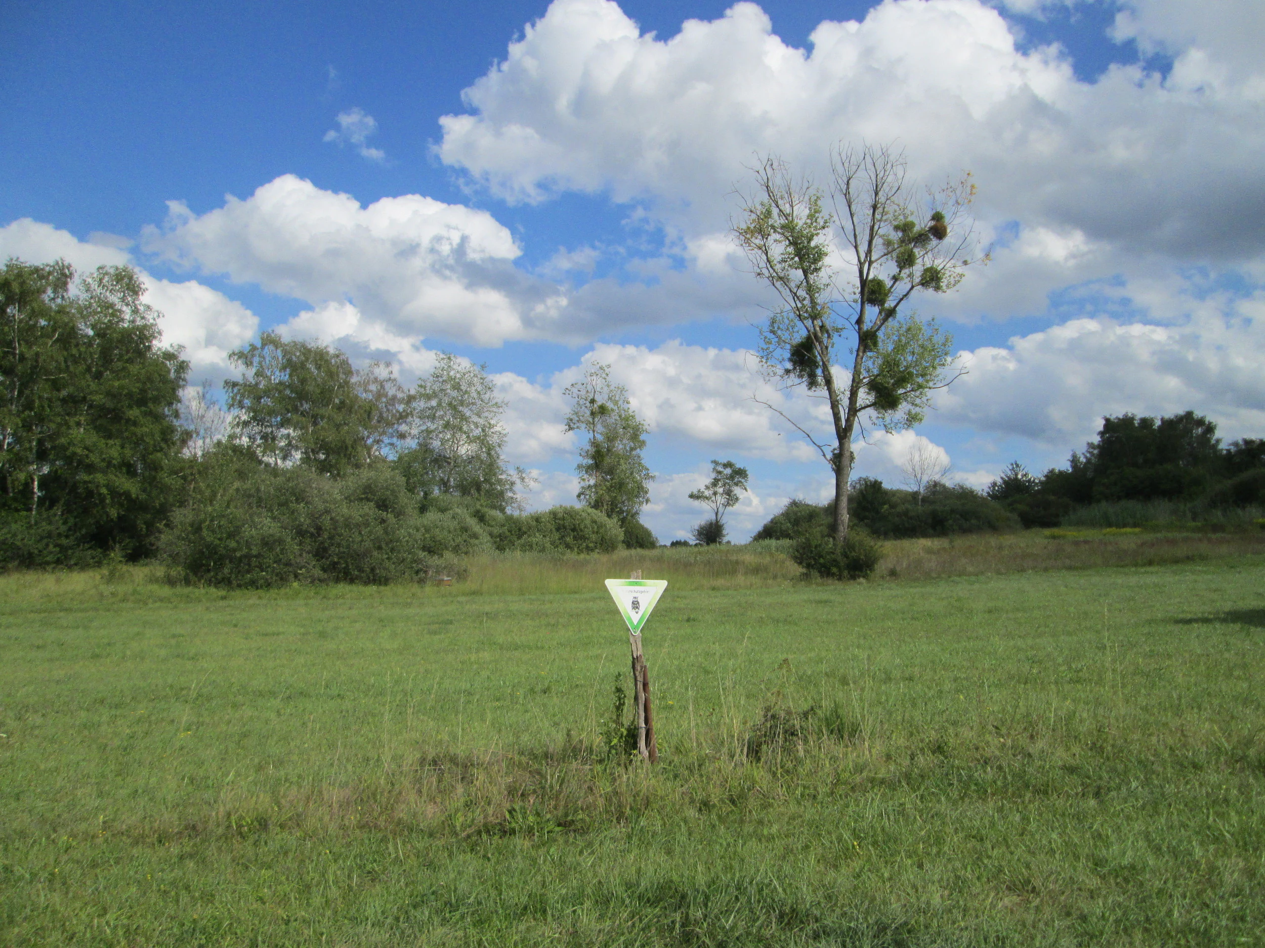
A green grassland meadow with a white triangular boundary marker on a wooden post in the foreground, scattered trees and shrubs in the background under a blue sky with white cumulus clouds.
Green meadow in the Beierwies sub-area of the Wusterhang und Beierwies nature reserve near Fechingen, marked by a triangular boundary post.

Wusterhang und Beierwies bei Fechingen history and protected-area timeline

The area that is now Wusterhang und Beierwies bei Fechingen had long existed as a mix of forest and traditionally managed meadows on the outskirts of Fechingen, but it lacked formal protected status for most of the modern era.

On 22 January 2016, the site, then covering approximately 11.06 hectares, was officially designated as a Naturschutzgebiet under the nature conservation legislation of the state of Saarland. The designation consolidated the two areas Wusterhang and Beierwies into a single protected entity. Since then, the reserve has been recorded in national and international conservation databases, including the World Database on Protected Areas, reflecting its recognition as a formally protected habitat area within the Regionalverband Saarbrücken.

Wusterhang und Beierwies bei Fechingen landscape and geographic character

The landscape of Wusterhang und Beierwies bei Fechingen is shaped by the gentle topography of the Saarland's southwestern hill country, where forested slopes alternate with small valleys and meadow hollows. This terrain produces an environment where woodland and grassland habitats can meet across short distances, generating the habitat gradients that define the reserve.

The woodland component includes stands of woodruff beech forest on more typical, moderately base-rich soils, as well as a more specialised pocket of Central European calcareous beech forest on substrates rich in calcium carbonate. These forests occupy the hillside sections of the reserve and are interspersed with small clearings and transitions into grassland.

The open parts of the reserve are made up of species-rich meadows and low-intensity grassland, including Molinia meadows on more humid sites and dry, nutrient-poor grasslands on shallower, well-drained sections. The southern boundary of the area is marked by the Flughafenstraße, a road that also visually separates the reserve from surrounding fields and the wider Saarbrücken landscape.

Wusterhang und Beierwies bei Fechingen ecosystems, habitats, and plant life

The ecological character of Wusterhang und Beierwies bei Fechingen rests on the juxtaposition of woodland and open-ground habitat types, several of which are considered priorities for conservation at the European level. Together they create a small but unusually rich ecological mosaic.

Key habitat types include Molinia meadows on more acidic, moisture-retaining substrates; species-rich meadows dominated by meadow foxtail and great burnet on moderately nutrient-rich soils; and dry, nutrient-poor grasslands characteristic of Magerrasen sites. The woodland habitats include woodruff beech forest, a widespread but ecologically valuable type, and the much rarer Central European calcareous beech forest, known for its exceptionally diverse ground flora and its association with orchids.

The combination of these habitats in close proximity means that transitions between forest and open ground can support edge and ecotone species alongside those tied to closed canopy or fully open conditions, giving the reserve a broader biodiversity signature than its modest size would suggest.

Wusterhang und Beierwies bei Fechingen wildlife and species highlights

Although this is a very small nature reserve, its habitat diversity supports a notable set of species, particularly among invertebrates and plants of conservation concern. The meadow and grassland habitats are particularly important for butterflies, with the Large Copper (Lycaena dispar) being a flagship species for the reserve's protection goals.

The calcareous beech forest component provides habitat for specialist woodland flora, including various orchids. Open and semi-open habitats, especially the meadows, host populations of rare plants such as the common fringed gentian and several marsh orchids of the genus Dactylorhiza, which together with the Large Copper butterfly form the most prominent conservation-relevant species of the site.

The reserve also sustains the broader community of woodland and grassland fauna typical of such habitat mosaos in the Saarland, even though the available documentation focuses primarily on the specific species highlighted in its protection objectives.

Wusterhang und Beierwies bei Fechingen conservation status and protection priorities

The conservation significance of Wusterhang und Beierwies bei Fechingen lies in the protection of a compact but ecologically valuable combination of habitat types and species that have become rare or threatened in the Saarland. Its formal designation as a Naturschutzgebiet in January 2016 committed the site to long-term protection under Saarland nature conservation law.

The protection objectives specifically target the maintenance of Molinia meadows, low-nutrient meadows, woodruff beech forest, and Central European calcareous beech forest, the last of which is widely regarded as a habitat of high European conservation importance. These habitat types form the structural basis for the reserve's value and align it with broader European habitat protection frameworks.

A second, species-focused layer of conservation applies to the Large Copper butterfly and to rare plants such as the common fringed gentian and various Dactylorhiza orchids. Together, the habitat- and species-based protection goals give the reserve a clear, focused conservation profile despite its small size.

Top sights and standout views in Wusterhang und Beierwies bei Fechingen

Wusterhang und Beierwies bei Fechingen stands out for packing an unusually high number of distinct, conservation-relevant habitat types into a tiny southern Saarland reserve, with both orchid-rich calcareous beech forest and traditional semi-natural meadows occurring side by side.

The reserve's two named sub-areas, Wusterhang and Beierwies, together anchor the site on the rural-urban fringe between Fechingen and Saarbrücken Airport. Its protected status, modest extent, and specialist species focus make it a representative example of small-scale, habitat-driven nature conservation in the Regionalverband Saarbrücken.

Best time to visit Wusterhang und Beierwies bei Fechingen

Wusterhang und Beierwies bei Fechingen is a small, quiet reserve best appreciated in late spring and early summer, when the species-rich meadows and calcareous beech forest ground flora, including wild orchids and the tall flower spikes of great burnet, are in active growth. Early summer also offers the best chance of observing the Large Copper butterfly in flight across its meadow habitat.

Late summer and early autumn bring the tall, purple-hued flower heads of Molinia, which gives the wet meadows much of their seasonal character. Winter visits remain possible but are less rewarding for those interested in the reserve's most distinctive botanical and butterfly features.

Monthly climate preview

Long-term temperature ranges and monthly precipitation patterns across the coordinate sample

Wusterhang und Beierwies bei Fechingen Climate Normals and Average Temperatures

Representative coordinates record measured monthly averages spanning sub-zero winter minimums to warm summer highs alongside steady precipitation. Examining the complete twelve-month climatology reveals detailed shifts in temperature and moisture distribution across the terrain.
Annual mean10 °C
0 °C19 °C
Jan
Feb
Mar
Apr
May13°
Jun17°
Jul19°
Aug19°
Sep15°
Oct10°
Nov
Dec
Warmest month
July

19.5 °C

Coolest month
January

0.5 °C

Wettest month
December

2.6 mm/day

Driest month
April

1.6 mm/day

Park location guide

Geography guide, regional context, and park location map for Wusterhang und Beierwies bei Fechingen

Wusterhang und Beierwies bei Fechingen park geography, regions, and map view in Germany

Understand where Wusterhang und Beierwies bei Fechingen sits in Germany through a broader geographic reading of the surrounding landscape, nearby location context, and its mapped position within the national park landscape.

How Wusterhang und Beierwies bei Fechingen fits into Germany

Germany is a federal republic in Western and Central Europe with a population of over 83 million across sixteen constituent states. It is Europe's largest economy by nominal GDP and a major global exporter and importer. The capital is Berlin, and the country borders Denmark, Poland, Czech Republic, Austria, Switzerland, France, Luxembourg, Belgium, and the Netherlands.

Wider geography shaping Wusterhang und Beierwies bei Fechingen in Germany

Germany is located in Western and Central Europe, spanning 357,022 km². It borders Denmark to the north, Poland and the Czech Republic to the east, Austria and Switzerland to the south, and France, Luxembourg, Belgium, and the Netherlands to the west. The country has coastlines on the Baltic Sea and North Sea to the north, with the Alps located in the southern region.

Map view of Wusterhang und Beierwies bei Fechingen

Use this park location map to pinpoint Wusterhang und Beierwies bei Fechingen in Germany, understand its exact geographic position, and read its mapped placement within the surrounding landscape more clearly.

Pigeon | © OpenStreetMap contributors

Location context for Wusterhang und Beierwies bei Fechingen

Saarland

Visual exploration of protected hill forests, orchid meadows, and rare habitats

Wusterhang und Beierwies bei Fechingen Landscape and Scenery Photos

Photographic documentation reveals the intricate mosaic of hillside beech forest and species-rich grassland across the reserve. Visual analysis of terrain gradients and protected habitats provides deeper insight into conservation features.

A green grassland meadow with a white triangular boundary marker on a wooden post in the foreground, scattered trees and shrubs in the background under a blue sky with white cumulus clouds.

Park atlas

Compare surrounding regional nature reserves and connected woodland habitats.

Parks Near Wusterhang und Beierwies bei Fechingen and Related Protected Areas

Browse other protected areas near Wusterhang und Beierwies bei Fechingen to examine similar grassland and beech forest habitats across the surrounding hill country. Regional park comparison reveals how small reserves fit into the broader conservation network of southwestern Germany.
A soft watercolor illustration depicting a panoramic landscape with rolling green hills, distant pink-hued mountains, and a rocky outcrop in the foreground.
Nature reserveSaarland
About 1.9 km away#1 closest

South

Birzberg, Honigsack/Kappelberghang bei Fechingen: Saarland Protected Nature Reserve Geography

Mapping the slope woodlands and riparian habitats near Saarbrücken

Spanning 188 hectares across the Saar valley margins, this nature reserve is defined by its varied hillside topography and calcareous soil influence. The protected area supports a complex mosaic of woodland slopes and grassland environments, providing a crucial habitat corridor within the Saarland region of Germany.

Area
1.88 km²
Established
2016
Nature reserveSaarland
About 9.8 km away#2 closest

Southeast

Südlicher Bliesgau/Auf der Lohe: Mapped Protected Landscape in Saarland, Germany

Calcareous slopes and meadow habitat conservation areas

Located in the Saarpfalz-Kreis district, Südlicher Bliesgau/Auf der Lohe provides a focused conservation look at the slopes and ridges bordering the Blies river valley. The area showcases Muschelkalk geology and semi-open cultural landscapes, serving as a critical habitat for specialized plant communities within this unique German-French border geography.

Area
15.75 km²
Established
2004
IUCN
IV
A soft watercolor illustration depicting a river flowing through a lush green floodplain with trees, grasses, and a hazy background.
Nature reserveSaarland
About 12 km away#3 closest

East

Bliesaue zwischen Blieskastel und Bliesdalheim Nature Reserve and Regional Landscape Geography

Protected floodplain ecosystems in Saarland, Germany

The Bliesaue zwischen Blieskastel und Bliesdalheim protects a near-natural river course and its surrounding floodplain in the Saarland region. The reserve is characterized by complex soil conditions from Buntsandstein and Muschelkalk substrates, supporting a rich network of wetlands, marshes, and meadows that function as a cohesive ecological unit for migratory birds and protected species.

Area
1.981 km²
Established
2015
Relief
Lowland
Climate
Temperate
Nature reserveSaarland
About 16 km away#4 closest

East

Badstube Mimbach Nature Reserve: Protected Limestone Grasslands and Woodland in Saarland

A regional atlas exploration of Saarland biodiversity hotspots

Badstube Mimbach stands as a significant nature reserve located within the Bliesgau region of Saarland. This protected landscape is defined by its south-facing limestone slopes and terraced fields, providing essential habitat for rare flora and specialized fauna in a compact ten-hectare mosaic of open meadow and beech forest.

Area
0.095 km²
Established
2016
IUCN
IV
Nature reserveGermany
About 17 km away#5 closest

Northeast

Taubental Nature Reserve: Protected Landscape and Forest Geography in Germany

Core zone forest conservation in the Saarpfalz district.

Taubental Nature Reserve protects a continuous stretch of mixed broadleaf and coniferous forest situated on the Buntsandstone ridges of southwestern Germany. As a core zone within the Bliesgau Biosphere, it maintains essential habitat connectivity despite its proximity to major regional infrastructure, providing a unique case study in forest preservation within the Saarpfalz-Kreis landscape.

Area
4.26 km²
Established
2007
Nature reserveSaarland
About 20 km away#6 closest

Northwest

Breitborner Floß Nature Reserve: Mapping the Protected Landscape and Geography of Saarland

A vital habitat complex across the Saarlouis district

Breitborner Floß stands as a significant protected nature reserve in the Saarland state of Germany. Covering a mosaic of alluvial forests, silicate grasslands, and wet meadows, the site serves as a prime example of compact landscape conservation. Explore the mapped boundaries and natural terrain features that define this key component of the European Natura 2000 network.

Area
0.39 km²
Established
2015
IUCN
IV
Relief
Upland
A soft, artistic watercolor painting showing a wide, tranquil wetland scene with soft green and yellow hues, distant rolling hills, and patches of trees and vegetation in a floodplain environment.
Protected landscapeSaarland
About 21 km away#7 closest

Northeast

Beeder Bruch Protected Landscape: Blies River Floodplain and Wetland Geography in Saarland

A managed riverine sanctuary in the Bliesgau Biosphere Reserve

Beeder Bruch is a formally recognized protected landscape in Saarland, defined by the extensive floodplain of the Blies river. The site integrates wet meadows, riparian forests, and reedbeds, serving as a key European bird protection zone. Visitors can explore the mapped terrain, which utilizes conservation grazing to maintain essential wetland habitats and support local biodiversity within the Bliesgau region.

Area
127 km²
Established
2015
IUCN
V
Nature reserveSaarland
About 22 km away#8 closest

North

Täler der Ill und ihrer Nebenbäche: Nature Reserve and River Valley Geography in Saarland

Protected riparian landscapes and stream corridor networks.

Täler der Ill und ihrer Nebenbäche preserves the interconnected valley ecosystems of the Ill river and its tributaries in central Saarland. This nature reserve maps a chain of riverine habitats that follow the natural course of the watercourses across the hill country. The landscape displays the relationship between formal protected areas and the surrounding regional geography, emphasizing the preservation of wetland corridors and riparian environments.

Area
10.45 km²
Established
2005
IUCN
IV

Common questions about visiting, size, designation, and location context for Wusterhang und Beierwies bei Fechingen

Wusterhang und Beierwies bei Fechingen FAQs for park facts, access, geography, and protected area context

Find quick answers about Wusterhang und Beierwies bei Fechingen, including protected-area facts, park geography, trail and visitor context, and how the park fits into its surrounding country and regional landscape.
MoriAtlas Explorer

Continue Your Protected Areas Search Across the Global Atlas

Deepen your exploration by continuing the structured search for national parks and protected areas worldwide. Utilize the comprehensive filtering capabilities to compare different conservation landscapes and refine your understanding of global park geography. Discover more about the distribution and characteristics of protected natural areas.

Global natural geography