Mori Atlas logo
Nature reserveAbe Bailey Nature Reserve

Analyzing the diverse grassland and wetland mosaic across the West Rand plateau

Abe Bailey Nature Reserve: Geographic Atlas and Protected Highveld Landscapes in Gauteng

Abe Bailey Nature Reserve covers 4,200 hectares of rolling highveld terrain in the Merafong City Local Municipality of Gauteng. This protected area acts as a crucial ecological refuge where grasslands and seasonal wetlands converge with the Gatsrand ridge, forming a complex habitat matrix. Users can analyze the reserve's mapped boundaries, internal drainage lines, and the surrounding transition zone between urbanized West Rand landscapes and open highveld plains.

highveld grasslandswetlandsbirdwatchingprotected areaWest RandGauteng

Abe Bailey Nature Reserve

Nature reserve

Park overview

Structured park overview, official facts, and landscape profile for Abe Bailey Nature Reserve

Abe Bailey Nature Reserve park facts, protected area profile, and essential visitor context

Review the core facts for Abe Bailey Nature Reserve, including designation, size, terrain, visitor scale, habitats, and operating context in one park-focused overview.

About Abe Bailey Nature Reserve

Abe Bailey Nature Reserve is a mid-sized protected area on the West Rand of Gauteng, occupying a landscape where highveld grasslands, seasonal wetlands, and rocky ridges converge. Located near Carletonville and the township of Khutsong, the reserve spans roughly 4,200 hectares and lies at the foot of the Gatsrand, a low mountain range that frames the reserve to one side and offers a corridor for wildlife moving between higher ground and lower plains.

The reserve is administered as a protected area within the Merafong City Local Municipality, where land use is shaped significantly by gold mining and urban settlement. Against this pressure, Abe Bailey Nature Reserve provides a substantial continuous block of natural habitat that preserves the character of the West Rand's grasslands and wetlands. Its position along the boundary between flatter highveld and the Gatsrand gives it ecological complexity within a relatively compact area.

For visitors and naturalists, the reserve is primarily appreciated as a birding destination. The presence of more than 280 bird species, combined with seasonal congregations of flamingos and a documented yellow-billed stork breeding site, makes it a notable inland birding location within South Africa. At the same time, the reserve offers mammal viewing opportunities that reflect the broader highveld fauna, with several antelope species and a surprising diversity of small carnivores. As a combination of accessibility from Gauteng and ecological richness, Abe Bailey Nature Reserve is an important component of the province's network of natural areas.

Quick facts and research context for Abe Bailey Nature Reserve

Abe Bailey Nature Reserve covers about 4,200 hectares in Gauteng, South Africa, on the West Rand near Carletonville and the township of Khutsong. It lies within the South African highveld and borders the Gatsrand range, which connects the reserve to a wider network of rocky and grassland habitats. The protected area is known primarily for its birdlife, with over 280 recorded species, as well as for typical highveld mammal fauna including black wildebeest, blesbok, plains zebra, and several species of small carnivores.

Protection and recognition

Review documented protected area designation records and official conservation status data.

Abe Bailey Nature Reserve Protection Status and Terrestrial Conservation Scope

Abe Bailey Nature Reserve holds recorded terrestrial protection scope within its regional conservation boundaries. Documented management facts and administrative designations outline the official preservation framework for this reserve.

Protection details

Protection scope
Terrestrial
Transboundary protection
No
Park context

Deeper park guide and search-rich context for Abe Bailey Nature Reserve

Abe Bailey Nature Reserve history, landscape, wildlife, and travel context

Explore Abe Bailey Nature Reserve through its history, landscape character, ecosystems, wildlife, conservation priorities, cultural context, and seasonal travel timing in a structured park guide built for atlas discovery and search intent.

Why Abe Bailey Nature Reserve stands out

The reserve is best known for its exceptional bird diversity, particularly the seasonal flocks of flamingos that use its wetlands, and for the presence of the yellow-billed stork, which breeds here at one of the few known sites outside the Okavango Delta. It is also recognized as a stronghold of highveld grassland wildlife, where species such as black wildebeest, blesbok, red hartebeest, and plains zebra roam alongside smaller carnivores including caracal, serval, and aardwolf.

Abe Bailey Nature Reserve history and protected-area timeline

Detailed information about the establishment, founding date, and administrative history of Abe Bailey Nature Reserve is not well documented in the available source material. Beyond its identification as a protected area in the Merafong City Local Municipality and its association with the West Rand's natural landscape, the reserve's historical background, including its origins, original land use, or formal designation process, cannot be reliably described from the provided content.

Abe Bailey Nature Reserve landscape and geographic character

The reserve occupies a transitional landscape where the open plains of the South African highveld meet the lower slopes of the Gatsrand range. Much of the terrain consists of rolling grasslands typical of the West Rand, interspersed with seasonal wetlands and drainage lines that create important habitat for waterbirds during wetter periods. The Gatsrand ridge provides rocky slopes and slightly higher ground along one edge of the reserve, adding topographic variety to an otherwise relatively flat plateau setting.

Wetlands are a defining feature of the reserve's landform. These seasonal or semi-permanent water bodies draw large numbers of wading birds, including flamingos for short periods each year, and provide the open water conditions that support species such as the African fish eagle and the visiting osprey. The surrounding grassland matrix, with its mix of grasses and scattered low vegetation, complements the wetland system and shapes the sense of openness that characterizes the reserve.

Abe Bailey Nature Reserve ecosystems, habitats, and plant life

Ecologically, Abe Bailey Nature Reserve reflects the highveld grassland biome of South Africa's interior plateau, with habitats that include open grassland, seasonal wetland, and rocky slopes along the Gatsrand. This combination of habitats allows the reserve to support both species that depend on grassland and those that require water, wetland edge, or rocky terrain, making it more ecologically diverse than a pure grassland reserve of the same size.

The wetland component stands out as a particular ecological asset. Seasonal flooding and water level changes create conditions for breeding waterbirds and seasonal concentrations of large waders, while the surrounding grassland sustains grazing-dependent mammals. The proximity of the Gatsrand further extends the habitat mosaic, allowing some species to move between the reserve and the broader rocky landscape, which strengthens the area's ecological connectivity.

Abe Bailey Nature Reserve wildlife and species highlights

The reserve is unusually rich in both birds and mammals. It hosts more than 280 recorded bird species, including African fish eagles, visiting ospreys, large seasonal flocks of flamingos, and the yellow-billed stork, which breeds here at one of its few known sites outside the Okavango Delta. Raptors are also represented by martial eagles, Cape vultures, white-backed vultures on rare occasions, and Verreaux's eagle-owls, while marabou storks have also been recorded.

Mammal diversity is notable for a reserve of this size. The black-backed jackal, caracal, and serval function as the apex predators present, supported by smaller carnivores including the Cape fox, aardwolf, African clawless otter, marsh mongoose, yellow mongoose, common slender mongoose, white-tailed mongoose, African striped weasel, striped polecat, and occasional honey badger. Brown hyena males are known to move through the area, although females have not been recorded.

Highveld antelope define much of the reserve's mammal identity. Indigenous species such as black wildebeest, blesbok, red hartebeest, plains zebra, springbok, common duiker, and steenbok are present, with occasional visits from mountain reedbuck, southern reedbuck, and common warthog moving in from the Gatsrand. Leopards are also known to enter the reserve from the Gatsrand, although sightings remain rare. Smaller, often unseen mammals include the southern African hedgehog and aardvark, adding to the reserve's broader biodiversity.

Abe Bailey Nature Reserve conservation status and protection priorities

Abe Bailey Nature Reserve plays a meaningful conservation role within the heavily developed West Rand of Gauteng, where mining and urban growth have placed continuous pressure on natural habitat. By maintaining a roughly 4,200-hectare block of highveld grassland, wetland, and adjacent rocky ridge, the reserve preserves a representative sample of habitats that have become increasingly fragmented across the province.

From an avifaunal perspective, the reserve is significant for both resident and migratory birds. The presence of yellow-billed stork breeding, large seasonal flamingo aggregations, and a recorded species list above 280 birds gives it conservation relevance that extends beyond the regional scale. Its function as a refuge for highveld mammal species, including antelope and several small carnivores, further reinforces its importance as a biodiversity anchor in Gauteng's landscape.

Abe Bailey Nature Reserve cultural meaning and human context

The reserve lies adjacent to Khutsong, a township near Carletonville, and is part of the Merafong City Local Municipality, a region historically shaped by gold mining on the West Rand. While the available source material does not provide detailed indigenous or community heritage information, the reserve's proximity to settled communities implies a relationship between local populations and the surrounding natural landscape that is part of the broader West Rand identity, though specific cultural dimensions are not documented in the provided source.

Top sights and standout views in Abe Bailey Nature Reserve

Abe Bailey Nature Reserve's standout qualities lie in the combination of its highveld grasslands, seasonal wetlands, and unusually rich birdlife. The seasonal gatherings of flamingos, the documented yellow-billed stork breeding site outside the Okavango Delta, and the more than 280 recorded bird species together give the reserve a distinct avifaunal profile within Gauteng.

Equally notable is the reserve's mammal community, which includes a strong suite of highveld antelope alongside small carnivores such as caracal, serval, and aardwolf, and even occasional leopard visits from the Gatsrand. Together with its position on the West Rand near Carletonville and Khutsong, these features make Abe Bailey Nature Reserve a meaningful natural refuge within one of South Africa's most urbanized provinces.

Best time to visit Abe Bailey Nature Reserve

The reserve is shaped by the seasonal rhythms of the South African highveld. Wet season conditions, broadly associated with the warmer summer months, tend to fill the wetlands and produce the most active birdlife, including the seasonal visits of flamingos and other waterbirds that rely on standing water. This period is generally the most rewarding for birdwatching and for observing the reserve at its most visually lush.

During the drier winter months, water levels in the wetlands typically fall and large flocks of flamingos are not present, though resident species such as African fish eagle, raptors, and highveld antelope remain visible against the golden grass landscape. Cooler, drier conditions may also make mammal viewing easier, as animals concentrate around remaining water sources. Visitors seeking the reserve's signature bird events will likely find the wetter half of the year more rewarding, while those interested in mammal viewing and clearer highveld vistas may still find value in the drier season.
Monthly climate preview

Long-term temperature and precipitation records measured at representative coordinates

Abe Bailey Nature Reserve Climate Normals and Monthly Weather Statistics

Historical averages for Abe Bailey Nature Reserve reveal a structured annual cycle of shifting temperatures and monthly precipitation patterns from NASA climatology data. Examining the complete twelve-month profile provides deeper analytical insight into long-term meteorological trends across the protected area.
Annual mean17 °C
10 °C22 °C
Jan22°
Feb22°
Mar20°
Apr17°
May13°
Jun10°
Jul10°
Aug13°
Sep17°
Oct20°
Nov21°
Dec22°
Warmest month
January

22.4 °C

Coolest month
July

9.6 °C

Wettest month
December

3.7 mm/day

Driest month
July

0.1 mm/day

Park location guide

Geography guide, regional context, and park location map for Abe Bailey Nature Reserve

Abe Bailey Nature Reserve park geography, regions, and map view in South Africa

Understand where Abe Bailey Nature Reserve sits in South Africa through a broader geographic reading of the surrounding landscape, nearby location context, and its mapped position within the national park landscape.

How Abe Bailey Nature Reserve fits into South Africa

South Africa is the southernmost country in Africa, spanning 1.22 million km² with a population of over 63 million. The country operates with three capital cities, Pretoria (executive), Cape Town (legislative), and Bloemfontein (judicial), and is renowned for its biodiversity, national parks, and multicultural society.

Wider geography shaping Abe Bailey Nature Reserve in South Africa

South Africa occupies the southernmost region of Africa, with coastline along both the Atlantic Ocean to the west and the Indian Ocean to the east. The interior features elevated plateaus including the Highveld, with the Drakensberg escarpment marking the eastern highlands. The country shares borders with Namibia, Botswana, Zimbabwe, Mozambique, Eswatini, and Lesotho.

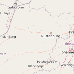
Map view of Abe Bailey Nature Reserve

Use this park location map to pinpoint Abe Bailey Nature Reserve in South Africa, understand its exact geographic position, and read its mapped placement within the surrounding landscape more clearly.

Pigeon | © OpenStreetMap contributors

Location context for Abe Bailey Nature Reserve

Gauteng
Park atlas

Compare adjacent highveld habitats, wetland reserves, and regional protected landscapes

Explore Parks Near Abe Bailey Nature Reserve and Regional Protected Areas

Browsing other protected areas near Abe Bailey Nature Reserve reveals the diverse ecological network spanning the surrounding Gauteng highveld region. Comparing these adjacent grassland and wetland habitats provides essential geographic context for regional conservation patterns.
Watercolor painting of a river flowing through a hilly, green valley with rocky cliffs on the right.
Biosphere reserveNorth West
About 58 km away#1 closest

Northeast

Magaliesberg Biosphere Reserve: Geographic Overview and Protected Area Landscape Mapping

Ancient mountain ranges in South Africa

The Magaliesberg Biosphere Reserve features a rugged terrain of high ridges and deep kloofs that support a vast array of bird species and vegetation. As a significant conservation area in North West, it preserves geological history alongside critical transitional ecosystems. Discover the mapped boundaries and natural features of this protected region that bridges urban centers and wilderness.

Area
3,578.7 km²
Established
2015
Relief
Mountain
Climate
Subtropical
A watercolor painting showing a wide, panoramic view of rolling green and yellow hills, scattered acacia-like trees, and a distant purple mountain range under a light sky.
Nature reserveNorth West
About 59 km away#2 closest

North

Kgaswane Mountain Reserve: Map and Geographic Profile of the Magaliesberg Range

A protected nature reserve in the North West province of South Africa.

Kgaswane Mountain Reserve stands as a pivotal protected landscape within the Magaliesberg Biosphere. This atlas record provides insights into its quartzitic ridges, complex grassland and woodland ecosystems, and status as a Ramsar wetland site, offering a clear view of its geographic and conservation significance.

Area
53 km²
Established
1967
A watercolor illustration of rolling green hills, distant mountains, and a pale sky.
Protected landscapeNorth West
About 61 km away#3 closest

Northeast

Magaliesberg Protected Natural Environment: Mapped Geography and Protected Landscape Context

Ancient mountain ridges between Rustenburg and Pretoria

Spanning a long quartzite ribbon, the Magaliesberg Protected Natural Environment represents a sophisticated model of private land conservation. The geography reveals a dramatic elevation gradient where Highveld plateaus meet lower-lying bushveld terrain. This atlas entry details the protected boundaries and the integrated landscape connection between surrounding nature reserves.

Area
343.56 km²
Established
1994
Relief
Mountain
Scope
Terrestrial
A soft watercolor illustration depicting rolling green hills and subtle landscape features on a white background.
Nature reserveGauteng
About 105 km away#4 closest

Northeast

Klapperkop Nature Reserve: Mapping Protected Bankenveld and Highveld Landscapes

A vital protected nature reserve in Gauteng, South Africa

Klapperkop Nature Reserve protects a representative segment of threatened highveld bankenveld grassland near Pretoria. The reserve features the distinct Klapperkop hill, historic fortifications, and restored savanna ecosystems that offer a window into the natural heritage of the Gauteng region.

Area
4.6 km²
Established
1898
Relief
Upland
Climate
Subtropical
Wildlife reserveGauteng
About 117 km away#5 closest

East

Marievale Bird Sanctuary: A Wildlife Reserve and Wetland Habitat in Gauteng, South Africa

Discover protected floodplain geography and wetland mapping

Marievale Bird Sanctuary preserves a complex network of pans and reedbeds along the Blesbokspruit. As a landmark of South African conservation, the area offers a focused look at how wetland ecosystems function within the Highveld topography of Gauteng, providing a critical refuge for diverse water-dependent species and migratory birds.

Area
15.26 km²
Established
1978
Relief
Lowland
Climate
Temperate
A pale, minimalist watercolor painting depicting rolling green hills in the distance with a winding dirt path leading through grassy plains in the foreground.
National parkNorth West Province
About 118 km away#6 closest

North

Pilanesberg National Park: Geologic Mapping of a South African Alkaline Ring Complex

Explore concentric volcanic terrain and protected bushveld landscapes

Pilanesberg National Park covers the eroded root of a massive 1.2 billion year old volcano. Its defining feature is a series of concentric hills and basins that rise from the flat bushveld plains of South Africa. This protected area offers a distinct geographic study in volcanic topography, featuring rocky syenite outcrops, open savanna, and varied water sources that define the ecological character of this significant regional landscape.

Area
572 km²
Established
1984
Relief
Mountain
Climate
Subtropical
Wildlife reserveNorth West Province
About 135 km away#7 closest

North

Borakalalo Game Reserve: Protected Bushveld and Aquatic Landscapes in North West Province

Mapping a diverse South African wildlife reserve

Borakalalo Game Reserve features a distinct ecological setting within South Africa, combining woodland bushveld with the aquatic ecosystems of Klipvoor Dam. This protected area provides a habitat for varied mammal species and an extensive bird list, set against the backdrop of the interior plateau landscape in North West Province.

Area
130 km²
Relief
Upland
Access
Access unknown
Scope
Terrestrial
Watercolor illustration depicting a winding river through a grassy landscape with rolling hills and distant trees under a soft yellow sky.
Wildlife reserveGauteng
About 151 km away#8 closest

Northeast

Dinokeng Game Reserve: Geographic Atlas and Protected Wildlife Area Profile

Savanna Landscapes and Riverine Corridors in Gauteng

Dinokeng Game Reserve functions as a primary wildlife sanctuary within Gauteng, South Africa, featuring a diverse mosaic of grassland and riverine bushveld. This atlas profile details the reserve geographic layout, from the Pienaars River watercourses to its integrated conservation zones, providing a clear overview of the terrain that supports its status as a significant regional protected area.

Area
210 km²
Established
2011
Relief
Upland
Climate
Subtropical

Common questions about visiting, size, designation, and location context for Abe Bailey Nature Reserve

Abe Bailey Nature Reserve FAQs for park facts, access, geography, and protected area context

Find quick answers about Abe Bailey Nature Reserve, including protected-area facts, park geography, trail and visitor context, and how the park fits into its surrounding country and regional landscape.
MoriAtlas Explorer

Continue Your Protected Areas Search Across the Global Atlas

Deepen your exploration by continuing the structured search for national parks and protected areas worldwide. Utilize the comprehensive filtering capabilities to compare different conservation landscapes and refine your understanding of global park geography. Discover more about the distribution and characteristics of protected natural areas.

Global natural geography