Mori Atlas logo
Wildlife reserveMarievale Bird Sanctuary

Explore the geography of open water pans, dense reedbeds, and floodplain terrain in this essential South African sanctuary.

Marievale Bird Sanctuary: A Protected Wetland Wildlife Reserve in the Gauteng Province of South Africa

Marievale Bird Sanctuary stands as a vital protected wetland reserve located along the Blesbokspruit in the Gauteng region of South Africa. Encompassing extensive reedbeds and shallow water pans, the area serves as a primary geographic anchor for migratory and resident wetland species within the Highveld landscape. This sanctuary provides a rare, undisturbed glimpse into the interconnected aquatic and terrestrial ecosystems that persist despite surrounding urban and industrial developments.

wetlandRamsar siteImportant Bird Areabirdwatchingwaterbird sanctuaryfloodplain

Marievale Bird Sanctuary

Wildlife reserve

Park overview

Structured park overview, official facts, and landscape profile for Marievale Bird Sanctuary

Marievale Bird Sanctuary park facts, protected area profile, and essential visitor context

Review the core facts for Marievale Bird Sanctuary, including designation, size, terrain, visitor scale, habitats, and operating context in one park-focused overview.

About Marievale Bird Sanctuary

Marievale Bird Sanctuary sits within one of South Africa's most heavily urbanized regions, yet it preserves a surprisingly intact wetland landscape. The sanctuary straddles the southern half of the Blesbokspruit, a perennial river whose seasonal flooding historically shaped extensive floodplains. Today, the reserve is organized around a series of water pans separated by dense stands of reeds, sedges, bulrushes, and duckweed, with patches of grassland extending toward its eastern edge.

Despite being surrounded by mining, agriculture, sewage works, and expanding urban development, Marievale has retained its character as a refuge for wetland wildlife. The slow-moving waters and fringing vegetation create favorable conditions for fish, frogs, and invertebrates, which in turn support a complex food web anchored by waterbirds. Bird hides positioned along the pans, including the interestingly named Flamingo, Hadeda, Duiker, and Shelduck hides, allow visitors to observe this dynamic birdlife at close range.

The sanctuary's broader significance lies in its role within a network of protected and semi-protected areas on the Highveld, including its proximity to the larger Suikerbosrand Nature Reserve. Together, these landscapes safeguard remnant grassland and wetland ecosystems that have been greatly reduced by human activity. Marievale is therefore not only a destination for birdwatchers but also an important node for conservation, ecological monitoring, and environmental education in Gauteng.

Quick facts and research context for Marievale Bird Sanctuary

Marievale Bird Sanctuary lies in Gauteng province, South Africa, on the East Rand near the town of Nigel. It occupies the southern portion of the Blesbokspruit wetland and covers approximately 1,526 hectares. The site is internationally designated as a Ramsar wetland of importance and is also recognized as an Important Bird Area, with nearly 300 bird species recorded by WESSA. Establishment date: 26 April 1978, later enlarged from an original 524-hectare reserve.

Protection and recognition

Documented terrestrial protected area status and official designation context

Marievale Bird Sanctuary Protection Status and Conservation Scope

Marievale Bird Sanctuary maintains a documented terrestrial protection scope and structured conservation framework for regional wetland habitats. Official records assemble baseline management data and international recognition metrics to verify environmental status.

Protection details

Protection scope
Terrestrial
Transboundary protection
No
Park context

Deeper park guide and search-rich context for Marievale Bird Sanctuary

Marievale Bird Sanctuary history, landscape, wildlife, and travel context

Explore Marievale Bird Sanctuary through its history, landscape character, ecosystems, wildlife, conservation priorities, cultural context, and seasonal travel timing in a structured park guide built for atlas discovery and search intent.

Why Marievale Bird Sanctuary stands out

Marievale is best known for its exceptional bird diversity within a compact inland wetland setting. The combination of open water pans, Phragmites and Typha reedbeds, and surrounding floodplain grasslands supports a rich mix of resident waterbirds, secretive marsh species, and seasonal migrants. Birdwatchers visit specifically to see species such as Goliath heron, purple heron, slaty egret, African rail, martins, and seasonal flocks of flamingos, making the sanctuary a flagship birding site in Gauteng.
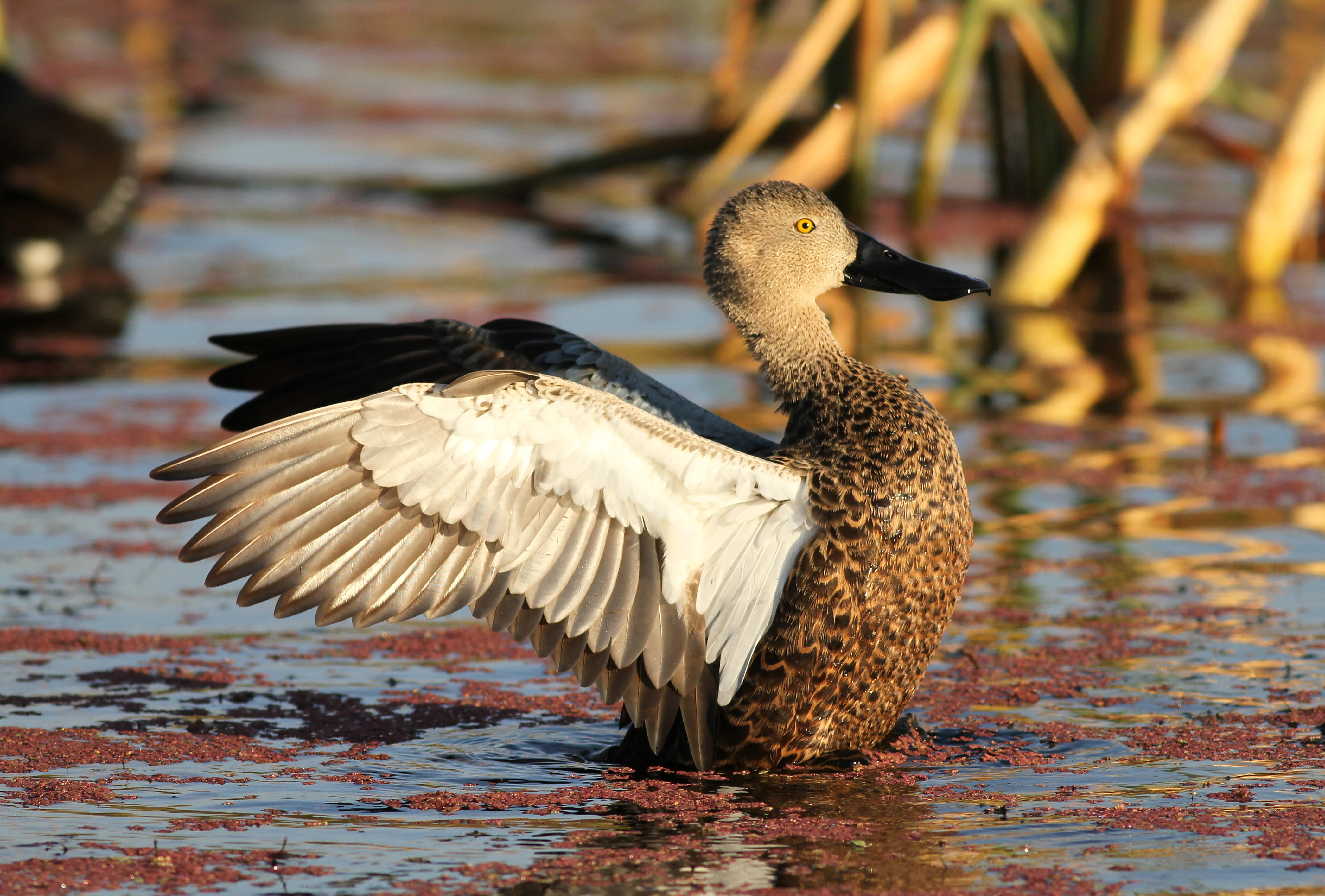
A brown duck with a distinctive large bill and white wing patches standing in a wetland with red floating aquatic plants.
A Cape Shoveler with wings spread at Marievale Bird Sanctuary, South Africa.

Marievale Bird Sanctuary history and protected-area timeline

Marievale was formally established as a reserve in 1978, when an initial area of 524 hectares was set aside for conservation. Over time, the reserve was progressively expanded to its current extent of approximately 1,526 hectares. Its later recognition as a Ramsar site marked a significant moment in its conservation history, elevating the sanctuary from a regional protected area to one of international wetland significance.

In the decades since establishment, the sanctuary's surrounding landscape has changed dramatically. Mining operations, sewage treatment facilities, agricultural expansion, and urban development have all encroached on the Blesbokspruit catchment. These pressures altered the hydrology and vegetation of the wetland, transforming a once more open river system into the disjointed series of vegetated pans seen today. Managing the reserve amid these external pressures has become a central part of its modern history.

Marievale Bird Sanctuary landscape and geographic character

The landscape of Marievale is defined by water, reeds, and flat floodplain terrain. The Blesbokspruit runs through the reserve in a slow, meandering course, historically flanked by broad seasonal floodplains. Within the sanctuary, water is now held in a chain of shallow pans separated by thick reedbeds of Phragmites, Typha, and Juncus, with floating mats of duckweed covering parts of the surface.

Large sand embankments deposited during nearby urban and industrial expansion have further reshaped the terrain, breaking the historic flow of the river and creating the isolated wetland basins that characterize the area today. Along the eastern edge of the reserve, the wetland transitions into open grassland biome, giving the reserve a clear gradient from aquatic to terrestrial habitat. The result is a patchwork of shallow water, dense reed, sedge marsh, and open grass, all on relatively flat Highveld topography.
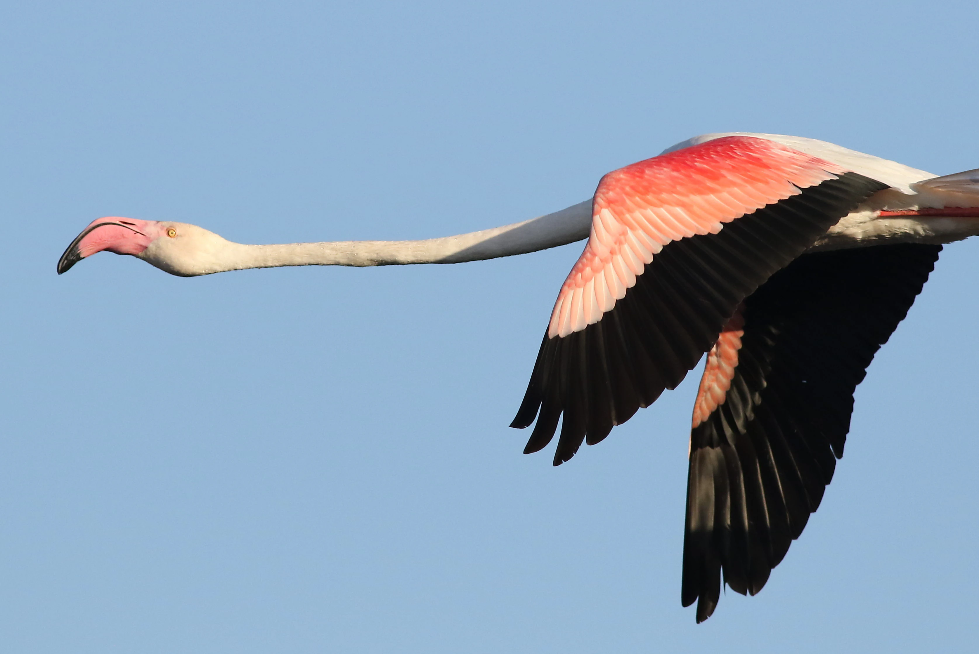
A Greater Flamingo with its neck extended and wings spread wide flying against a clear blue sky.
A Greater Flamingo in flight at Marievale Bird Sanctuary.

Marievale Bird Sanctuary ecosystems, habitats, and plant life

Marievale's ecological identity is overwhelmingly wetland-driven, yet it also contains meaningful grassland elements. The aquatic vegetation includes tall reeds, bulrushes, sedges, and floating plants such as duckweed, which together create the structural complexity that waterbirds rely on for feeding, nesting, and shelter. These plant communities stabilize the pans and provide crucial cover for fish, frogs, and aquatic invertebrates.

At the margins of the wetland, a grassland biome takes over, supporting grasses and low herbaceous plants adapted to the seasonal climate of the Highveld. The juxtaposition of open water, dense marsh, and dry grassland within a single reserve gives Marievale its ecological richness, enabling it to host species with very different habitat requirements within a small geographic area.
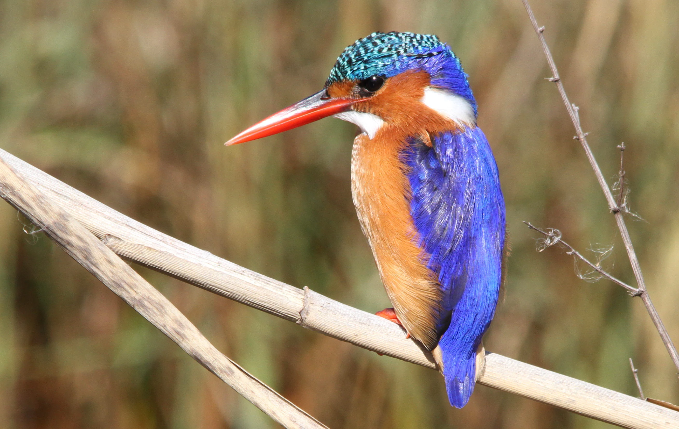
A close up profile view of a vibrant Malachite Kingfisher with bright blue feathers, a reddish orange chest, and a long red beak perched on a thin, dry reed.
A Malachite Kingfisher perched on a reed at Marievale Bird Sanctuary.

Marievale Bird Sanctuary wildlife and species highlights

Marievale is most famous for its birds, but mammals add another important layer to its biodiversity. The sanctuary hosts nearly 300 bird species according to records from the Wildlife and Environment Society of South Africa, including iconic wetland species such as the Goliath heron, purple heron, squacco heron, slaty egret, black heron, great egret, yellow-billed duck, South African shelduck, red-knobbed coot, reed cormorant, and African spoonbill.

More secretive wetland species are also recorded, including the African grass owl, marsh owl, Baillon's crake, red-chested flufftail, African rail, and black crake. Seasonal migrants widen the bird list significantly, with regular appearances by species such as curlew sandpiper, black-tailed godwit, pectoral sandpiper, buff-breasted sandpiper, Baird's sandpiper, black-winged pratincole, fulvous whistling duck, Caspian tern, western yellow wagtail, and sand martin. Flamingos, including both greater and lesser flamingo, occasionally gather on the pans.

Mammal sightings within the reserve include blesbok, southern reedbuck, Cape hare, three species of mongoose including the yellow mongoose, and otters such as the Cape clawless otter and spotted-necked otter. These mammals reflect the reserve's character as a transitional landscape between wetland and grassland, supporting both water-dependent and open-country species.
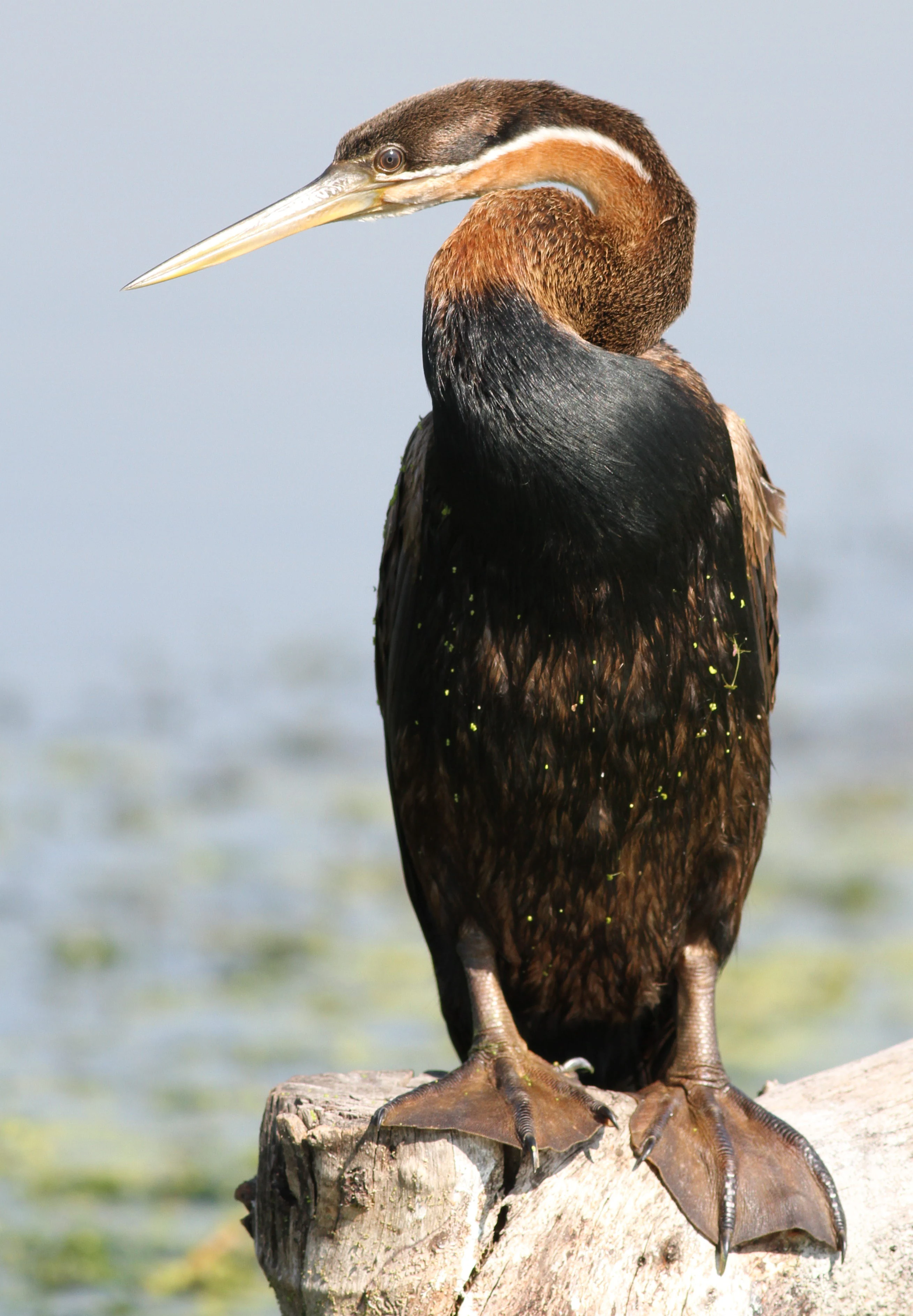
A side profile portrait of an African darter bird with a long neck and pointed bill, standing on a wooden log above water.
An African darter perched on a log in the wetland at Marievale Bird Sanctuary.

Marievale Bird Sanctuary conservation status and protection priorities

Marievale's conservation importance is rooted in its international recognition as a Ramsar wetland, placing it among a select group of South African wetlands regarded as significant at a global scale. It also qualifies as an Important Bird Area, reflecting its exceptional bird diversity in a relatively small inland reserve. Together, these designations highlight Marievale's role in safeguarding wetland habitat under intense regional pressure.

The reserve's conservation value is heightened by its location within a heavily transformed landscape on Gauteng's East Rand. Surrounding gold mining operations, mine tailings deposits, sewage treatment works, farmland, and urban expansion have significantly altered the hydrology of the Blesbokspruit, fragmenting the original river into discrete wetland pans. While the proliferation of reeds and other wetland vegetation has, in some areas, improved cover for wildlife, it has also reduced open-water habitat that certain waterbirds depend on. Maintaining a balance of open water, reedbed, and grassland is therefore a central concern for the reserve's ongoing management.

Top sights and standout views in Marievale Bird Sanctuary

Marievale's main highlights are its exceptional waterbird diversity, its Ramsar and Important Bird Area status, and its role as a green refuge within a heavily industrialized part of Gauteng. The chain of vegetated pans, linked by hides named after characteristic species (Flamingo, Hadeda, Duiker, Shelduck), offers some of the most accessible and rewarding birdwatching in the province. Combined with the presence of mammals such as blesbok and otters, Marievale delivers a remarkably full wetland experience in a compact reserve.
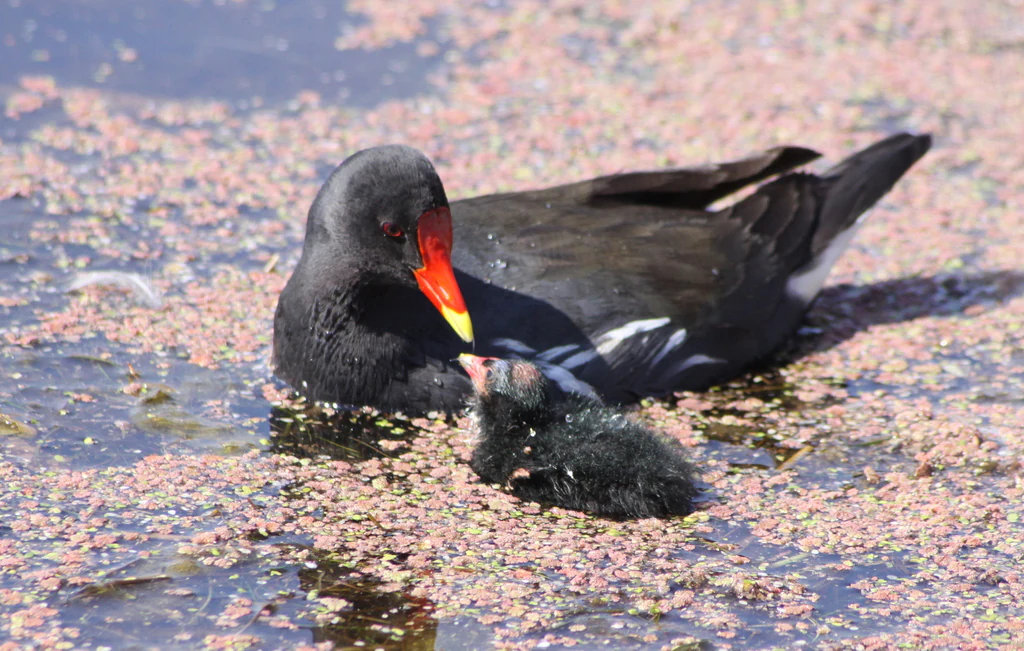
An adult Common Moorhen with a small black fluffy juvenile chick swimming together in water covered with duckweed.
A Common Moorhen feeding its juvenile chick at Marievale Bird Sanctuary.

Best time to visit Marievale Bird Sanctuary

According to WESSA, the most rewarding period to visit Marievale is between spring and the start of summer, when seasonal conditions and migratory patterns bring a particularly rich mixture of species to the pans. During this window, both resident waterbirds and arriving migrants are active, water levels tend to be favorable for waders, and the reeds and surrounding grasslands are at their most lush. Early morning visits are generally the most productive for observing feeding and movement across the wetland.
Monthly climate preview

Long-term monthly temperature and precipitation patterns across representative coordinates

Marievale Bird Sanctuary Climate Normals and Annual Temperature Rhythm

Marievale Bird Sanctuary exhibits a measured annual climate cycle defined by warm summer months and cooler winter periods alongside distinct precipitation shifts. Examining the comprehensive monthly climate records provides a detailed breakdown of historical averages across the entire year.
Annual mean16 °C
9 °C21 °C
Jan21°
Feb21°
Mar19°
Apr16°
May12°
Jun
Jul
Aug12°
Sep17°
Oct19°
Nov20°
Dec20°
Warmest month
January

20.8 °C

Coolest month
July

8.9 °C

Wettest month
December

4.1 mm/day

Driest month
July

0.1 mm/day

Park location guide

Geography guide, regional context, and park location map for Marievale Bird Sanctuary

Marievale Bird Sanctuary park geography, regions, and map view in South Africa

Understand where Marievale Bird Sanctuary sits in South Africa through a broader geographic reading of the surrounding landscape, nearby location context, and its mapped position within the national park landscape.

How Marievale Bird Sanctuary fits into South Africa

South Africa is the southernmost country in Africa, spanning 1.22 million km² with a population of over 63 million. The country operates with three capital cities, Pretoria (executive), Cape Town (legislative), and Bloemfontein (judicial), and is renowned for its biodiversity, national parks, and multicultural society.

Wider geography shaping Marievale Bird Sanctuary in South Africa

South Africa occupies the southernmost region of Africa, with coastline along both the Atlantic Ocean to the west and the Indian Ocean to the east. The interior features elevated plateaus including the Highveld, with the Drakensberg escarpment marking the eastern highlands. The country shares borders with Namibia, Botswana, Zimbabwe, Mozambique, Eswatini, and Lesotho.

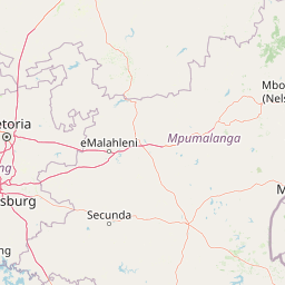
Map view of Marievale Bird Sanctuary

Use this park location map to pinpoint Marievale Bird Sanctuary in South Africa, understand its exact geographic position, and read its mapped placement within the surrounding landscape more clearly.

Pigeon | © OpenStreetMap contributors

Location context for Marievale Bird Sanctuary

Gauteng

Visualizing open water pans, reedbeds, and Highveld floodplain terrain

Marievale Bird Sanctuary Photos and Wetland Landscape Scenery

Examine detailed photographs capturing the aquatic habitats, dense reed marshes, and expansive grassland transitions of Marievale Bird Sanctuary. Visual records reveal the distinct wetland topography and protected landscape character defining this Gauteng reserve.

A brown duck with a distinctive large bill and white wing patches standing in a wetland with red floating aquatic plants.

A Greater Striped Swallow with a rufous head and streaked breast, perched on a textured stone surface.

A Greater Flamingo with its neck extended and wings spread wide flying against a clear blue sky.

A close up profile view of a vibrant Malachite Kingfisher with bright blue feathers, a reddish orange chest, and a long red beak perched on a thin, dry reed.

A side profile portrait of an African darter bird with a long neck and pointed bill, standing on a wooden log above water.

A yellow mongoose with orange-brown fur walking across a green grassy field, viewed from the side.

An adult Common Moorhen with a small black fluffy juvenile chick swimming together in water covered with duckweed.

An African Rail standing on the ground near green grass, viewed from the side, showing its dark plumage, barred flanks, and orange-red beak.

A group of five flamingos flying low over a marshy wetland with tall reeds and shallow water.

A black crake bird with bright red legs, a yellow beak, and red eyes walking on a dusty pink-tinted surface.

A Southern Red Bishop bird with orange, black, and white plumage clinging to a vertical reed against a light grey background.

A black-headed heron with gray feathers and a long neck standing in shallow water among tall reeds and dry grasses.

Close-up portrait of an African Purple Swamphen showing its bright red bill, teal chest feathers, and deep blue body against a blurred background of dried reeds.

A Purple Heron stands in shallow wetland water covered in reddish duckweed or algae, surrounded by dried reed stalks.

A black Red-knobbed Coot bird flying low over calm, reflective wetland water with tall reeds visible in the background.

Side profile of a White-throated Swallow with iridescent blue-black upperparts, a white throat, a chestnut forehead patch, and light-colored underparts, perched on a bare twig against a plain light background.

Park atlas

Compare regional wetland reserves and surrounding Highveld conservation areas.

Exploring Parks Near Marievale Bird Sanctuary and Related Protected Landscapes

Discover protected areas near Marievale Bird Sanctuary to examine regional wetland geography and grassland ecosystems. Comparing adjacent reserves helps trace the broader ecological spread of the surrounding Highveld landscape.
A soft watercolor illustration depicting rolling green hills and subtle landscape features on a white background.
Nature reserveGauteng
About 70 km away#1 closest

Northwest

Klapperkop Nature Reserve: Mapping Protected Bankenveld and Highveld Landscapes

A vital protected nature reserve in Gauteng, South Africa

Klapperkop Nature Reserve protects a representative segment of threatened highveld bankenveld grassland near Pretoria. The reserve features the distinct Klapperkop hill, historic fortifications, and restored savanna ecosystems that offer a window into the natural heritage of the Gauteng region.

Area
4.6 km²
Established
1898
Relief
Upland
Climate
Subtropical
Watercolor illustration depicting a winding river through a grassy landscape with rolling hills and distant trees under a soft yellow sky.
Wildlife reserveGauteng
About 78 km away#2 closest

North

Dinokeng Game Reserve: Geographic Atlas and Protected Wildlife Area Profile

Savanna Landscapes and Riverine Corridors in Gauteng

Dinokeng Game Reserve functions as a primary wildlife sanctuary within Gauteng, South Africa, featuring a diverse mosaic of grassland and riverine bushveld. This atlas profile details the reserve geographic layout, from the Pienaars River watercourses to its integrated conservation zones, providing a clear overview of the terrain that supports its status as a significant regional protected area.

Area
210 km²
Established
2011
Relief
Upland
Climate
Subtropical
Watercolor painting of a river flowing through a hilly, green valley with rocky cliffs on the right.
Biosphere reserveNorth West
About 108 km away#3 closest

Northwest

Magaliesberg Biosphere Reserve: Geographic Overview and Protected Area Landscape Mapping

Ancient mountain ranges in South Africa

The Magaliesberg Biosphere Reserve features a rugged terrain of high ridges and deep kloofs that support a vast array of bird species and vegetation. As a significant conservation area in North West, it preserves geological history alongside critical transitional ecosystems. Discover the mapped boundaries and natural features of this protected region that bridges urban centers and wilderness.

Area
3,578.7 km²
Established
2015
Relief
Mountain
Climate
Subtropical
A watercolor illustration of rolling green hills, distant mountains, and a pale sky.
Protected landscapeNorth West
About 110 km away#4 closest

Northwest

Magaliesberg Protected Natural Environment: Mapped Geography and Protected Landscape Context

Ancient mountain ridges between Rustenburg and Pretoria

Spanning a long quartzite ribbon, the Magaliesberg Protected Natural Environment represents a sophisticated model of private land conservation. The geography reveals a dramatic elevation gradient where Highveld plateaus meet lower-lying bushveld terrain. This atlas entry details the protected boundaries and the integrated landscape connection between surrounding nature reserves.

Area
343.56 km²
Established
1994
Relief
Mountain
Scope
Terrestrial
Nature reserveGauteng
About 117 km away#5 closest

West

Abe Bailey Nature Reserve: Geographic Profile and Highveld Protected Area Atlas

Mapped wetlands and grassland ecosystems in Gauteng, South Africa

Spanning 4,200 hectares, Abe Bailey Nature Reserve provides a vital green refuge on the West Rand. This protected area features a unique combination of highveld grassland, seasonal wetlands, and rocky ridges that support rich birdlife and antelope populations, standing as a significant conservation feature within an urbanized province.

Area
42 km²
Relief
Upland
Climate
Temperate
Access
Access unknown
A watercolor painting showing a wide, panoramic view of rolling green and yellow hills, scattered acacia-like trees, and a distant purple mountain range under a light sky.
Nature reserveNorth West
About 141 km away#6 closest

Northwest

Kgaswane Mountain Reserve: Map and Geographic Profile of the Magaliesberg Range

A protected nature reserve in the North West province of South Africa.

Kgaswane Mountain Reserve stands as a pivotal protected landscape within the Magaliesberg Biosphere. This atlas record provides insights into its quartzitic ridges, complex grassland and woodland ecosystems, and status as a Ramsar wetland site, offering a clear view of its geographic and conservation significance.

Area
53 km²
Established
1967
Wildlife reserveNorth West Province
About 149 km away#7 closest

Northwest

Borakalalo Game Reserve: Protected Bushveld and Aquatic Landscapes in North West Province

Mapping a diverse South African wildlife reserve

Borakalalo Game Reserve features a distinct ecological setting within South Africa, combining woodland bushveld with the aquatic ecosystems of Klipvoor Dam. This protected area provides a habitat for varied mammal species and an extensive bird list, set against the backdrop of the interior plateau landscape in North West Province.

Area
130 km²
Relief
Upland
Access
Access unknown
Scope
Terrestrial
Nature reserveLimpopo
About 175 km away#8 closest

North

Mabalingwe Nature Reserve: Protected Bushveld Geography and Terrain Analysis

Mapping the Limpopo reserve landscape and habitat features

Examine the 8,800-hectare landscape of Mabalingwe Nature Reserve. From its malaria-free bushveld habitat to its network of seasonal dams and mixed woodland terrain, this entry provides a clear look at the environmental context of this private Limpopo protected area.

Area
88 km²
Established
1989
Relief
Upland
Climate
Subtropical

Common questions about visiting, size, designation, and location context for Marievale Bird Sanctuary

Marievale Bird Sanctuary FAQs for park facts, access, geography, and protected area context

Find quick answers about Marievale Bird Sanctuary, including protected-area facts, park geography, trail and visitor context, and how the park fits into its surrounding country and regional landscape.
MoriAtlas Explorer

Continue Your Protected Areas Search Across the Global Atlas

Deepen your exploration by continuing the structured search for national parks and protected areas worldwide. Utilize the comprehensive filtering capabilities to compare different conservation landscapes and refine your understanding of global park geography. Discover more about the distribution and characteristics of protected natural areas.

Global natural geography