Mori Atlas logo
Nature reserveMabalingwe Nature Reserve

Analyzing the terrain, regional habitat, and mapped boundaries of this Limpopo nature reserve

Mabalingwe Nature Reserve: A Detailed Geographic Survey of Protected Bushveld Landscapes

Mabalingwe Nature Reserve covers approximately 8,800 hectares of classic Transvaal bushveld in the Limpopo province of South Africa. The protected area features a diverse terrain of undulating woodland, open grassy plains, and essential drainage lines that support a significant range of wildlife. This geographic profile details the reserve's habitat composition, the role of its seasonal water sources, and its position within the broader Waterberg-influenced bushveld ecosystem.

bushveld reserveLimpopoBig Fivemalaria-freeprivate game reservebirdwatching

Mabalingwe Nature Reserve

Nature reserve

Park overview

Structured park overview, official facts, and landscape profile for Mabalingwe Nature Reserve

Mabalingwe Nature Reserve park facts, protected area profile, and essential visitor context

Review the core facts for Mabalingwe Nature Reserve, including designation, size, terrain, visitor scale, habitats, and operating context in one park-focused overview.

About Mabalingwe Nature Reserve

Mabalingwe Nature Reserve occupies a substantial tract of bushveld approximately 28 kilometers west of Bela Bela in South Africa's Limpopo province. Its setting, in the broader Transvaal bushveld region, places it in a warm, mixed woodland environment characterized by open plains, scattered tree cover, drainage lines, and dams, all typical of the Waterberg-adjacent landscape. Because the reserve sits in a malaria-free zone, it is a convenient destination for visitors from Gauteng and the rest of South Africa looking for a Big Five game experience without the additional health precautions required further north.

The reserve's modern identity is built on a gradual, multi-decade transformation. What began as a 2,141-hectare maize and cattle farm called Boschpoort evolved into a safari-oriented game reserve of roughly 8,800 hectares, with added parcels, additional lodges, and a network of sectional title and share-block residential schemes collectively referred to as "the Greater Mabalingwe." Today, the estate supports a wide mix of stakeholders, including private farms, residential schemes, the Wessels family's Mabalingwe Game Reserve company, and bodies such as the Mabalingwe Common Property Association and Ludum Game Consortium.

Wildlife is central to the Mabalingwe experience. The reserve hosts the Big Five, together with an unusually diverse supporting cast that includes hippo, giraffe, hyena, warthog, and a broad spectrum of plains antelope, with more than 220 bird species recorded on site. Open 4x4 game drives are the main viewing activity, supplemented by self-guided exploration between safari launch points. Visitor infrastructure is unusually extensive for a private game reserve, including a main complex with 34 thatched chalets, four distinct accommodation camps, a caravan park, restaurants, bars, swimming pools, sport courts, and conference facilities, allowing Mabalingwe to function simultaneously as a wildlife reserve, a conferencing venue, and a residential estate.

Protection and recognition

Examine documented terrestrial protection metrics and official international recognition records.

Mabalingwe Nature Reserve Protection Status and Recognized Conservation Scope

Terrestrial protection status and management scope define the baseline conservation profile of Mabalingwe Nature Reserve. Documented records provide verified administrative details and official designation context for this protected natural area.

Protection details

Protection scope
Terrestrial
Transboundary protection
No
Park context

Deeper park guide and search-rich context for Mabalingwe Nature Reserve

Mabalingwe Nature Reserve history, landscape, wildlife, and travel context

Explore Mabalingwe Nature Reserve through its history, landscape character, ecosystems, wildlife, conservation priorities, cultural context, and seasonal travel timing in a structured park guide built for atlas discovery and search intent.

Why Mabalingwe Nature Reserve stands out

Mabalingwe is best known for its accessible malaria-free bushveld setting close to Johannesburg, its association with the Big Five, and its leopard-linked name "Spots of the leopard." The reserve is also notable for hosting elephant rescued from planned culling in Kruger National Park in the 1990s, and for disease-free African buffalo breeding, both of which became part of its conservation identity. Beyond wildlife, the reserve is recognized as one of the early South African estates where a working cattle and maize farm was progressively transformed into a multi-use game reserve, combining a wildlife estate, sectional-title developments, share-block schemes, and tourism lodges on a single property.
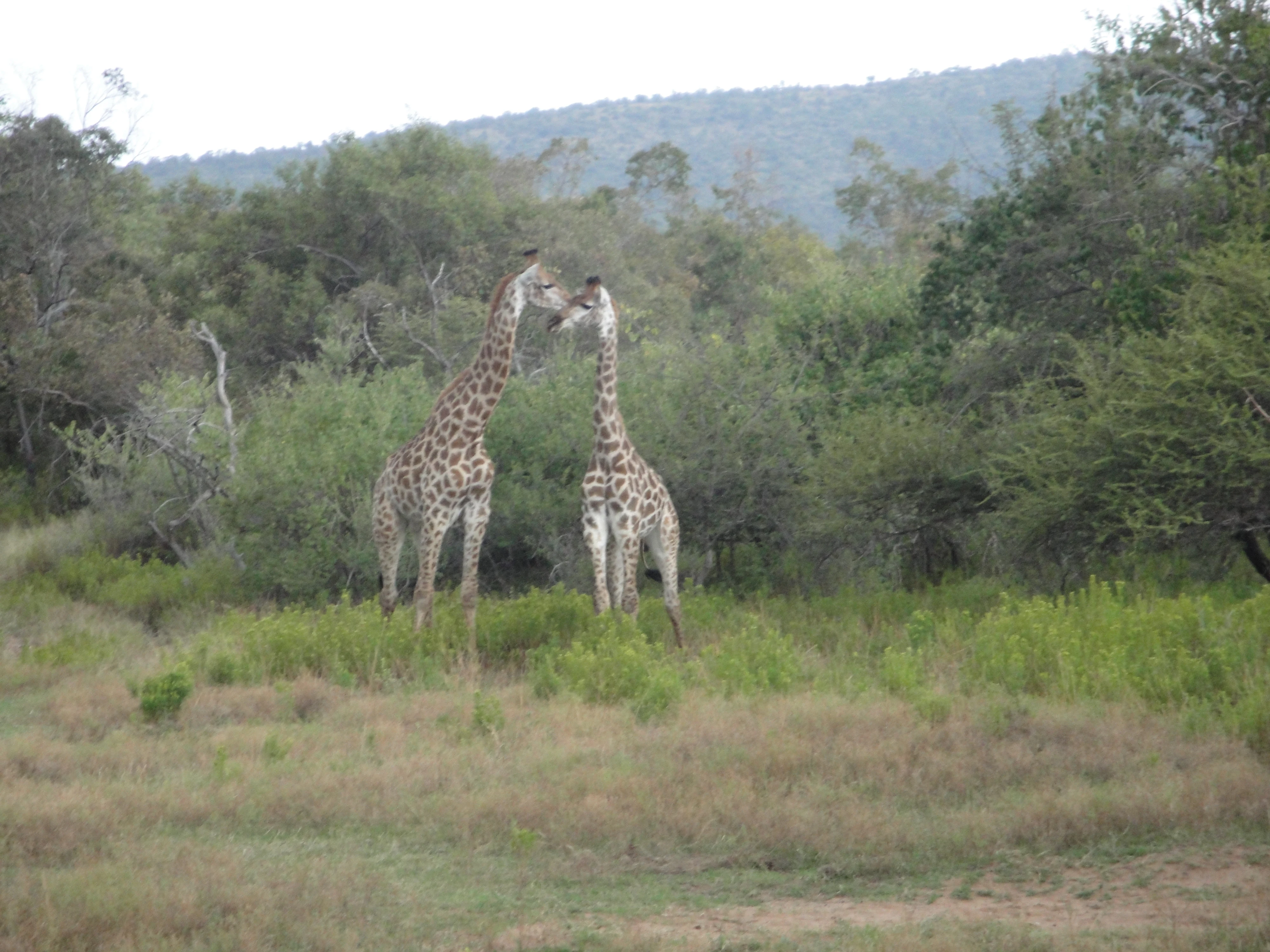
Two giraffes facing each other in a grassy, wooded landscape with hills in the background.
Two giraffes standing in the bushveld of Mabalingwe Nature Reserve.

Mabalingwe Nature Reserve history and protected-area timeline

Mabalingwe's history traces back to 1972, when the Wessels family founded a 2,141-hectare cattle and maize farm named Boschpoort. In its earliest form, the property was a typical working Transvaal farm, with kudu and impala as the only larger game present.

In 1987, Basie Wessels began converting Boschpoort into a vacation resort, with the first ten chalets completed in 1988. By 1989, hippopotamuses, southern white rhinoceroses, black rhinoceroses, and sable antelope had been introduced, and the property was being developed along game-reserve lines. Throughout the early 1990s, additional accommodations were added (reaching around 105 units by 1994), and neighboring farms were purchased to expand the reserve, including the adjacent Gorcum farm. In 1994, Basie's son Hannes, an architect by profession, returned to develop the caravan park and subsequent sectional title schemes on the property.

From the mid-1990s onward, conservation-focused additions became central to the reserve's emerging identity. In 1996, elephants earmarked for culling in Kruger National Park were rescued and resettled at Mabalingwe. Disease-free African buffalo breeding, initiated at Hoedspruit in 1999, also led to buffalo introductions to the reserve. By 2003, with additional farms such as Olievenfontein and Cyferfontein incorporated, Mabalingwe had grown to around 8,800 hectares, and a series of lodges, including Itaga, Boekenhoutplaat, and Elandsfontein, had been added. Earlier in 2003, the Mabalingwe Country Club (later known as Zebula/Zubula) was developed, briefly expanding the reserve to about 12,500 hectares before Zebula separated as a distinct entity, leaving Mabalingwe at its current core size.

Subsequent years brought continued growth in residential and tourism infrastructure, and by 2008 the development had become a multi-entity estate with various share-block companies and a common property association coordinating the broader reserve. In April 2008, Basie Wessels died in an autogyro crash, marking the end of the founding generation. In 2024 the Ingilozi sectional title development expanded the reserve to about 9,200 hectares, continuing the pattern of incremental growth through carefully integrated residential schemes.

Mabalingwe Nature Reserve landscape and geographic character

Mabalingwe sits in the warm, dry bushveld of the Transvaal, in a part of Limpopo that lies outside the malaria belt and within easy driving distance of Johannesburg. The terrain is characteristic of the broader Waterberg-influenced bushveld, with gently undulating ground, mixed woodland, open grassy plains, and seasonal drainage lines that feed local dams. The reserve's dams are central to both the landscape experience and the wildlife viewing, anchoring the main restaurant and ladies bar, which look out over the water.

The vegetation profile is classic mixed bushveld, with open savanna, scattered tree cover, and denser woody areas that transition into thicker thicket along watercourses and folds in the terrain. Visible rock and outcrop features, varying degrees of tree density, and a patchwork of open grazing plains create the visual variety typical of South African lowveld bush reserves. The relatively flat to gently rolling topography of the area makes the reserve particularly well suited to open-vehicle game drives, walking between lodges, and observing wildlife at the dams.

Mabalingwe Nature Reserve ecosystems, habitats, and plant life

As a bushveld reserve, Mabalingwe protects a representative example of the mixed savanna ecosystem that once covered much of the Transvaal region. The vegetation mosaic includes open grasslands, dense bush clumps, Acacia-dominated woodland, and thicker riverine thicket around the dams, creating a habitat patchwork that supports a wide variety of game species and birdlife.

The reserve's ecological value is reinforced by its size and its history of deliberate introductions. The introduction of white and black rhinoceros, the rescue and resettlement of elephants from planned culling in Kruger, and the breeding of disease-free African buffalo have helped expand the local gene pool within the broader Waterberg and Limpopo conservation landscape. The mix of habitats, combined with consistent water availability from the reserve's dams, supports both resident species and seasonal bird visitors, contributing to the documented bird list of more than 220 species.

Mabalingwe Nature Reserve wildlife and species highlights

Mabalingwe is home to the Big Five: lion, leopard, buffalo, elephant, and both white and black rhinoceros. Beyond the headline five, the reserve supports approximately 36 mammal species, including hippopotamus, giraffe, spotted hyena, warthog, kudu, impala, and sable antelope, the last of which has been part of the reserve's breeding program since the late 1980s. The leopard holds a particular place in the reserve's identity, reflected directly in the name Mabalingwe itself.

The reserve is also a notable birding destination, with more than 220 recorded bird species. The mix of dams, open bushveld, and denser woodland habitats supports a wide variety of raptors, waterbirds, and bushveld-resident species. Visitors typically encounter game through open 4x4 safari drives, with launch points positioned across the reserve to take advantage of waterholes, dams, and active game areas.

Mabalingwe Nature Reserve conservation status and protection priorities

Although Mabalingwe is a privately managed reserve rather than a formal state-run national park, its conservation significance is substantial. The reserve was developed from a working farm into a protected area explicitly designed to host large, wide-ranging species, including white and black rhinoceros, elephants, and lions, requiring coordinated habitat management across its roughly 8,800 hectares. Disease-free African buffalo breeding at Hoedspruit, parts of which were transferred to Mabalingwe, adds a recognized conservation role within the broader Limpopo network of game reserves.

The reserve also reflects the South African private-game reserve model, in which landowners reintroduce and manage formerly extirpated species on previously farmed land. By reintroducing Big Five species and taking in elephants rescued from culling, Mabalingwe has contributed to broader population management efforts in northern South Africa. Today, the reserve's fragmented but coordinated governance, including the Mabalingwe Common Property Association and various share-block and game companies, plays a key role in balancing wildlife management with residential and tourism uses across the estate.

Mabalingwe Nature Reserve cultural meaning and human context

Mabalingwe's name reflects the multilingual linguistic heritage of northern South Africa. The name is derived from "mabala ya ingwe," where "mabala" means "spots" in Tswana and "ingwe" is the Zulu word for "leopard." This blend of Tswana and Zulu in a single place name is typical of the cultural layers that characterize place names in the Limpopo and broader Waterberg region.

The reserve itself is a modern expression of evolving land use in the Transvaal: from a maize and cattle farm founded by the Afrikaner Wessels family in 1972, to a sectional-title and share-block residential estate combined with a game reserve. Through entities like Mabalingwe Nature Reserve Shareblock (Pty) Ltd, Mabalingwe Game Reserve (Pty) Ltd, and the Mabalingwe Common Property Association, the reserve reflects a newer South African model that merges private ownership, conservation land use, and community governance within a single bordered property.

Top sights and standout views in Mabalingwe Nature Reserve

Mabalingwe's standout features include its accessible and malaria-free bushveld setting within easy reach of Johannesburg; its elephant population, originally rescued from a planned cull in Kruger National Park; and its Big Five game-viewing experience built around roughly 8,800 hectares of carefully managed habitat and dams. The leopard-inspired name adds a distinctive cultural layer to a reserve that is also one of the more developed private bushveld estates in the region, with 34 main thatched chalets, four additional camps (Ingwe, Kubu, Phiri, and Kwalata), and a network of lodges, safari launch points, and residential schemes.

Best time to visit Mabalingwe Nature Reserve

Mabalingwe sits in the warm bushveld of Limpopo, where conditions are generally favorable for game viewing throughout the year. The dry winter months, typically from May through August, are often considered the most comfortable period to visit, with cooler temperatures, thinner vegetation, and wildlife concentrating more visibly around the reserve's dams and waterholes, which improves the chances of close encounters with the Big Five and other species.

The wetter summer months, from roughly November to March, bring lush greenery, active breeding behavior, and an influx of migrant and water-associated bird species, which can be especially rewarding for the reserve's birding community. Summer also brings higher temperatures and stronger afternoon thunderstorms, which can affect driving conditions on open-vehicle game drives but often deliver dramatic bushveld scenery.
Monthly climate preview

Long-term average temperature and precipitation patterns across representative coordinates

Mabalingwe Nature Reserve Climate Normals and Monthly Weather Records

Mabalingwe Nature Reserve exhibits a measured annual cycle of long-term average temperatures and precipitation values derived from representative coordinate sampling. Reviewing the complete monthly climate normals reveals granular temperature variations and precipitation distributions across the protected landscape.
Annual mean20 °C
13 °C25 °C
Jan25°
Feb24°
Mar23°
Apr20°
May16°
Jun13°
Jul13°
Aug16°
Sep21°
Oct23°
Nov24°
Dec25°
Warmest month
January

24.7 °C

Coolest month
July

12.9 °C

Wettest month
January

3.2 mm/day

Driest month
July

0 mm/day

Park location guide

Geography guide, regional context, and park location map for Mabalingwe Nature Reserve

Mabalingwe Nature Reserve park geography, regions, and map view in South Africa

Understand where Mabalingwe Nature Reserve sits in South Africa through a broader geographic reading of the surrounding landscape, nearby location context, and its mapped position within the national park landscape.

How Mabalingwe Nature Reserve fits into South Africa

South Africa is the southernmost country in Africa, spanning 1.22 million km² with a population of over 63 million. The country operates with three capital cities, Pretoria (executive), Cape Town (legislative), and Bloemfontein (judicial), and is renowned for its biodiversity, national parks, and multicultural society.

Wider geography shaping Mabalingwe Nature Reserve in South Africa

South Africa occupies the southernmost region of Africa, with coastline along both the Atlantic Ocean to the west and the Indian Ocean to the east. The interior features elevated plateaus including the Highveld, with the Drakensberg escarpment marking the eastern highlands. The country shares borders with Namibia, Botswana, Zimbabwe, Mozambique, Eswatini, and Lesotho.

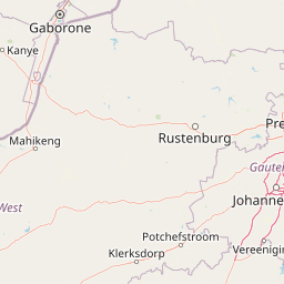
Map view of Mabalingwe Nature Reserve

Use this park location map to pinpoint Mabalingwe Nature Reserve in South Africa, understand its exact geographic position, and read its mapped placement within the surrounding landscape more clearly.

Pigeon | © OpenStreetMap contributors

Location context for Mabalingwe Nature Reserve

Limpopo

Visualizing the terrain, bushveld habitats, and protected environment of the Limpopo reserve.

Mabalingwe Nature Reserve Photos and Landscape Scenery

Visual documentation captures the undulating topography, mixed woodland vegetation, and open watering holes that define the protected landscape. Examining these field photographs reveals the distinct bushveld environment and wildlife habitats sustained across the Transvaal conservation estate.

Two giraffes facing each other in a grassy, wooded landscape with hills in the background.

Park atlas

Compare regional bushveld reserves and nearby conservation areas across Limpopo

Other Parks Near Mabalingwe Nature Reserve and Surrounding Protected Landscapes

Browsing other parks near Mabalingwe Nature Reserve reveals the broader ecological patterns of the surrounding Transvaal bushveld region. Comparing these protected areas provides valuable geographic context on regional wildlife habitats and diverse savanna landscapes.
Wildlife reserveLimpopo
About 16 km away#1 closest

Northwest

Mabula Game Reserve: Protected Bushveld and Geographic Landscape Profile

Exploration of the Limpopo bushveld and wildlife habitat boundaries

Mabula Game Reserve provides a detailed look at the bushveld ecosystems of South Africa. Spanning 12,000 hectares in Limpopo, the reserve features a unique blend of rocky ridges, open savanna, and riverine woodlands. Its structural diversity creates a distinct natural corridor that serves as a focal point for understanding regional wildlife distribution and the transition zone between the Waterberg and the northern plains.

Area
120 km²
Scope
Terrestrial
Wildlife reserveNorth West Province
About 43 km away#2 closest

Southwest

Borakalalo Game Reserve: Protected Bushveld and Aquatic Landscapes in North West Province

Mapping a diverse South African wildlife reserve

Borakalalo Game Reserve features a distinct ecological setting within South Africa, combining woodland bushveld with the aquatic ecosystems of Klipvoor Dam. This protected area provides a habitat for varied mammal species and an extensive bird list, set against the backdrop of the interior plateau landscape in North West Province.

Area
130 km²
Relief
Upland
Access
Access unknown
Scope
Terrestrial
Biosphere reserveLimpopo
About 44 km away#3 closest

North

Waterberg Biosphere: A Protected Sandstone Massif in Limpopo Province South Africa

Geology, mapping, and ecological zones of the Waterberg range

The Waterberg Biosphere stands as a major protected region in South Africa, formed by ancient sandstone layers sculpted into mesas and deep gorges. This massif bridges ecological zones from highland savanna to riverine habitats, anchoring a network of game reserves and wilderness areas through its distinctive geological and historical landscape identity.

Area
6,540.33 km²
Established
2001
Relief
Mountain
Climate
Subtropical
National parkLimpopo Province
About 48 km away#4 closest

Northwest

Marakele National Park: National Park Protected Landscape and Geographic Context

Explore its Limpopo Province regional setting and mapped boundaries.

Marakele National Park represents a vital protected national park within the diverse geography of Limpopo Province, South Africa. This entry provides detailed atlas-style information on its protected landscape, focusing on mapped geographic boundaries and its context within the regional natural terrain. It serves as a key resource for understanding the park's specific role as a conservation area and its place within the broader atlas of South African protected lands.

Area
670 km²
Established
1994
Relief
Mountain
Climate
Subtropical
Nature reserveLimpopo Province
About 66 km away#5 closest

East

Nylsvley Nature Reserve: A Geographical Overview of Limpopo Province's Wetland Landscapes

Protected floodplain ecosystems and seasonal riverine terrain

Nylsvley Nature Reserve protects a vast, shallow floodplain and surrounding open woodland, creating a high-density conservation zone in the Limpopo Province. Its terrain is defined by the seasonal interaction of the Nyl River, extensive reedbeds, and unique botanical communities. This profile examines the reserve as a significant reference point for understanding the interplay between floodplain geography, savanna bushveld, and inland wetland habitats.

Area
40 km²
Established
1998
Relief
Lowland
Access
Access unknown
Wildlife reserveLimpopo
About 71 km away#6 closest

North

Welgevonden Game Reserve: A Comprehensive Geographic Profile of a Limpopo Wildlife Haven

Mapped terrain across the Waterberg mountain bushveld

Welgevonden Game Reserve stands as a focal point for protected land discovery in South Africa. The reserve features complex geological formations, ranging from steep cliffs to open plateau grasslands. Gain insights into the physical boundaries and landscape diversity that define this significant conservation area located within the northern Limpopo province.

Area
382 km²
Relief
Mountain
Access
Access unknown
Scope
Terrestrial
A soft watercolor illustration depicting rolling green hills and subtle landscape features on a white background.
Nature reserveGauteng
About 107 km away#7 closest

South

Klapperkop Nature Reserve: Mapping Protected Bankenveld and Highveld Landscapes

A vital protected nature reserve in Gauteng, South Africa

Klapperkop Nature Reserve protects a representative segment of threatened highveld bankenveld grassland near Pretoria. The reserve features the distinct Klapperkop hill, historic fortifications, and restored savanna ecosystems that offer a window into the natural heritage of the Gauteng region.

Area
4.6 km²
Established
1898
Relief
Upland
Climate
Subtropical
A pale, minimalist watercolor painting depicting rolling green hills in the distance with a winding dirt path leading through grassy plains in the foreground.
National parkNorth West Province
About 107 km away#8 closest

Southwest

Pilanesberg National Park: Geologic Mapping of a South African Alkaline Ring Complex

Explore concentric volcanic terrain and protected bushveld landscapes

Pilanesberg National Park covers the eroded root of a massive 1.2 billion year old volcano. Its defining feature is a series of concentric hills and basins that rise from the flat bushveld plains of South Africa. This protected area offers a distinct geographic study in volcanic topography, featuring rocky syenite outcrops, open savanna, and varied water sources that define the ecological character of this significant regional landscape.

Area
572 km²
Established
1984
Relief
Mountain
Climate
Subtropical

Common questions about visiting, size, designation, and location context for Mabalingwe Nature Reserve

Mabalingwe Nature Reserve FAQs for park facts, access, geography, and protected area context

Find quick answers about Mabalingwe Nature Reserve, including protected-area facts, park geography, trail and visitor context, and how the park fits into its surrounding country and regional landscape.
MoriAtlas Explorer

Continue Your Protected Areas Search Across the Global Atlas

Deepen your exploration by continuing the structured search for national parks and protected areas worldwide. Utilize the comprehensive filtering capabilities to compare different conservation landscapes and refine your understanding of global park geography. Discover more about the distribution and characteristics of protected natural areas.

Global natural geography