

Mori Atlas logo
Biosphere reserveWaterberg Biosphere

A geographic study of ancient sandstone formations, cliff-side habitats, and the regional ecology of northern South Africa

Waterberg Biosphere Reserve: Mapping the Sandstone Massif and Protected Landscapes of Limpopo

(Waterberg Biosphere Reserve)

The Waterberg Biosphere encompasses a vast sandstone upland in Limpopo Province, defined by hundreds of millions of years of riverine erosion. This protected landscape is characterized by dramatic mesas, sheer bluffs, and isolated kopje outcrops that rise sharply from the surrounding Bushveld plains. Beyond its geological significance, the region supports a complex mosaic of dry deciduous forest, savanna grasslands, and riparian corridors, creating a contiguous system for conservation and ecological restoration.

biosphere reservesandstone massifdry deciduous forestBushveldsavannacliff habitats

Waterberg Biosphere

Biosphere reserve

Park overview

Structured park overview, official facts, and landscape profile for Waterberg Biosphere

Waterberg Biosphere park facts, protected area profile, and essential visitor context

Review the core facts for Waterberg Biosphere, including designation, size, terrain, visitor scale, habitats, and operating context in one park-focused overview.

About Waterberg Biosphere

The Waterberg Biosphere is one of South Africa's most ecologically and historically significant landscapes, occupying a large portion of the country's northern Limpopo Province. Stretching roughly 170 km from northeast to southwest and about 80 km from northwest to southeast, it is anchored by a rugged sandstone massif whose highest point, Geelhoutkop, reaches approximately 1,830 meters above sea level. The mountain range's average elevation sits around 600 meters, with some peaks rising further toward 2,000 meters.

Designated as a UNESCO Biosphere Reserve in 2001, the Waterberg became the first northern South African region to receive this recognition. The biosphere today encompasses around 654,033 hectares of contiguous landscape, integrating privately managed game reserves, protected wilderness areas, and working farmland focused on conservation. Marakele National Park lies along the western edge, while significant private reserves such as Welgevonden, Kololo, and the Lapalala Wilderness add further protected depth to the area.

Ecologically, the Waterberg is fundamentally a dry deciduous forest system sitting within the Bushveld biome. It is composed of multiple sub-habitats, including high plateau savanna, shaded cliff vegetation communities, and well-developed riparian corridors along rivers such as the Palala and Limpopo. This combination of habitats supports diverse flora and fauna, including large mammals, raptors, reptiles, and specialized cliff-dwelling plant species.

Beyond its natural character, the Waterberg has long yielded evidence of deep human presence. Stone Age deposits, Bushman rock art, Iron Age settlements, and dry-stone fortifications are all part of the regional heritage. The biosphere's modern management ethos blends conservation, ecotourism, ecological restoration, and cultural recognition, making it a compelling model of integrated landscape stewardship in southern Africa.

Quick facts and research context for Waterberg Biosphere

The Waterberg Biosphere lies in Limpopo Province of South Africa, centered on a sandstone massif that stretches roughly 170 km in length and 80 km in width.

It was designated as a UNESCO Biosphere Reserve in 2001 and covers about 654,033 hectares. The ecosystem is classified as a dry deciduous forest within the broader Bushveld biome, and its highest point, Geelhoutkop, reaches around 1,830 meters above sea level. The biosphere contains several major reserves, including Marakele National Park on its western edge, the Welgevonden Game Reserve, and the Lapalala Wilderness.

Protection and recognition

Documented terrestrial protection scope, 2001 designation history, and UNESCO recognition records

Waterberg Biosphere Protection Status and Official International Recognition Data

Waterberg Biosphere maintains documented terrestrial protection status supported by official international recognition history established in 2001. Structured records outline the established designation scope and verified UNESCO biosphere reserve data without implying conservation outcomes.

International recognition

Protection details

Protection scope
Terrestrial
Designated year
2001
Transboundary protection
No
Core area
1,041.79 km²
Buffer area
1,855.17 km²
Park context

Deeper park guide and search-rich context for Waterberg Biosphere

Waterberg Biosphere history, landscape, wildlife, and travel context

Explore Waterberg Biosphere through its history, landscape character, ecosystems, wildlife, conservation priorities, cultural context, and seasonal travel timing in a structured park guide built for atlas discovery and search intent.

Why Waterberg Biosphere stands out

The Waterberg Biosphere is particularly known for its dramatic sandstone landforms: mesas, buttes, bluffs, and isolated kopjes carved out by ancient river erosion. These formations create sheer cliffs that rise up to around 550 meters above the surrounding plains, providing both scenic character and sheltered cliff habitats. It is also recognized for its layered ecological zones, which combine high plateau savanna, specialized shaded cliff vegetation, and riverine corridors. Combined with deep archaeological and early human history, the Waterberg stands out as a landscape where geological time, ecological diversity, and human antiquity intersect in a single contiguous region.
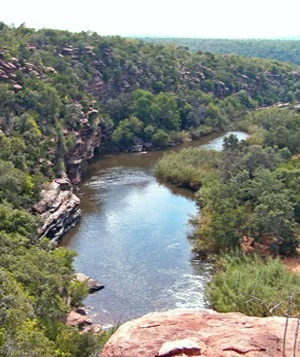
A high-angle view of a winding river flowing through a rocky, forested canyon with steep cliff walls and dense green vegetation.
A scenic view looking down into the Lapalala River gorge in the Waterberg Biosphere.

Waterberg Biosphere history and protected-area timeline

The history of the Waterberg stretches back many hundreds of thousands of years. Its sandstone formations retain groundwater and contain cliff overhangs that provided natural shelters for early human ancestors. Evidence from nearby Makapansgat suggests that early hominins such as Homo erectus may have moved seasonally into the higher elevations of the Waterberg in search of game.

Around two thousand years ago, Bushmen moved into the Waterberg, producing distinctive rock paintings that survive in protected areas like Lapalala. Their depictions of rhinoceros, antelope, and other wildlife provide a vivid record of the region's fauna at the time. Later Iron Age settlers from Bantu-speaking groups brought cattle into the region, eventually triggering ecological change as cattle grazing reduced grassland cover, encouraged brush invasion, and enabled the spread of the tsetse fly. The resulting sleeping sickness epidemic devastated populations on the lower plains, while people at higher elevations, above the fly's range, persisted.

From roughly 1300 AD onward, Nguni settlers introduced new technologies, including dry-stone wall building, which was applied to Iron Age forts whose defensive structures still stand today. European contact began in 1808 with the arrival of the first white settlers, followed by traveling Afrikaner groups in the mid-19th century. As the 19th and early 20th centuries progressed, increasing cattle grazing and land occupation placed heavy pressure on native wildlife populations, prompting a gradual shift toward conservation-oriented land management in the 20th century. The UNESCO Biosphere designation in 2001 marked a formal consolidation of the region's ecological and cultural value.

Waterberg Biosphere landscape and geographic character

The Waterberg is defined by its ancient sandstone massif, a deeply rugged upland whose formation extends back to the Neoarchean and early Paleoproterozoic eras. The bedrock derives from the Kaapvaal craton, with later igneous intrusions from the Bushveld Igneous Complex adding vanadium- and platinum-bearing rock to the geological fabric. Over hundreds of millions of years, riverine erosion sculpted this solid foundation into a dramatic suite of landforms.

The massif is dominated by mesas, buttes, and isolated kopje outcrops that rise sharply from the surrounding plains. Exposed multi-colored sandstone layers, often coarse-grained and yellow in tone, form steep cliff faces, with some bluffs reaching up to around 550 meters above the plain. The Sandrivier range near Vaalwater offers a textbook example of cross-bedded sandstone escarpment.

Coarse-grained sandstones appear across the range, particularly visible in formations like the Sandrivier escarpment. The geological base, drawn from the Kaapvaal craton with Bushveld Igneous Complex intrusions, has given rise to long, layered cliff faces that catch the South African light. The massif's combination of horizontal layering and differential erosion gives the Waterberg its signature profile of flat-topped massifs separated by deep river gorges.
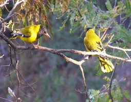
Two yellow birds with black heads perched on a tree branch.
A pair of Black-headed orioles perched on a tree branch in the Waterberg Biosphere.

Waterberg Biosphere ecosystems, habitats, and plant life

Ecologically, the Waterberg Biosphere is best understood as a dry deciduous forest system within the broader Bushveld biome. Its character emerges from a layered combination of sub-habitats rather than any single dominant ecosystem. According to ecological descriptions of the reserve, these sub-habitats include high plateau savanna, specialized shaded cliff vegetation systems, and riparian zone habitats with associated marshes.

The savanna consists of rolling grasslands interspersed with semi-deciduous woodland. Characteristic trees include mountain syringa, silver cluster-leaf, and the lavender tree, with the canopy often leafless through the dry winter months. Native grasses such as signal grass, goose grass, and heather-topped grass provide forage, and small isolated kopje formations host rare Pachypodium habitats.

Vegetative cliff habitats are abundant because of the Waterberg's extensive historic river erosion. These cliffs shelter trees such as the paperbark false-thorn, with its flaking bark hanging from thick trunks, and the fever tree, which holds cultural significance in Bushman tradition and grows above the Palala River near prehistoric ceremonial sites and intact rock paintings. Riparian corridors along the region's rivers ultimately drain into the Limpopo River and from there into the Indian Ocean, supporting river bushwillow and other water-dependent flora. Together these sub-habitats produce a mosaic of ecosystems within a single contiguous landscape.

Waterberg Biosphere wildlife and species highlights

The Waterberg's combined grassland, cliff, and riparian habitats support a rich and varied mammal community. Indigenous antelope species include impala, kudu, klipspringer, and blue wildebeest, which thrive in the savanna mosaic. Other notable mammals include South African giraffe, southern white rhinoceros, warthog, hippopotamus in the riverine zones, and apex predators such as the African leopard, hyena, and lion. The Nile crocodile inhabits the river systems of the Waterberg as a top predator.

The biosphere also hosts a notable snake fauna, including the black mamba and the spitting cobra. The Waterberg's snakes attracted early scientific study, most famously by Eugene Marais in 1905. The African porcupine finds shelter in cliffside caves, while birds such as the black-headed oriole and white-backed vulture occupy the riparian zones and escarpment edges. Because the wet habitats support relatively few water-living insects, the region is considered an almost malaria-free environment, an unusual feature for a South African landscape of this scale.

Waterberg Biosphere conservation status and protection priorities

As a UNESCO Biosphere Reserve designated in 2001, the Waterberg represents one of the most ambitious integrated conservation landscapes in northern South Africa. Its designation as the first biosphere reserve in northern South Africa reflects both its ecological richness and its deep cultural heritage. The biosphere framework combines formal protected areas with privately managed land committed to conservation-compatible use.

Key protected nodes include Marakele National Park on the western edge of the reserve, the Welgevonden Game Reserve covering 37,500 hectares of plateau, the smaller Kololo Game Reserve of 3,000 hectares, and the Lapalala Wilderness Nature Reserve, which at roughly 48,000 hectares is the largest private game reserve in both the Waterberg and Limpopo Province.

Modern conservation efforts in the Waterberg focus on restoration rather than only preservation. Where 20th-century cattle grazing destroyed native grass cover and reduced wildlife populations, landowners have increasingly reverted to restoring original grass species and reducing fences to allow large mammal migration. The added ecological value of restored habitat has stimulated ecotourism growth, creating an economic incentive that supports ongoing soil conservation and wildlife recovery. Larger consolidated farms and open-space corridors also improve genetic connectivity among mammal populations, making conservation both an ecological and an economic strategy in the biosphere.

Waterberg Biosphere cultural meaning and human context

The Waterberg carries an unusually layered human story. Stone Age occupation extending back potentially millions of years links the landscape to broader questions about the origin of humans in southern Africa. Bushman rock art at sites like Lapalala provides a vivid visual record of life and fauna in the region, depicting rhinoceros and antelope among other subjects.

Iron Age Bantu-speaking settlers shaped the ecological history of the plateau through cattle introduction, with cascading effects on grassland cover and disease patterns. Later Nguni arrivals contributed distinctive dry-stone architecture, examples of which still stand. Colonial-era encounters added further layers, including the striking account of mid-19th-century Afrikaner travelers who reached the Waterberg believing they had arrived in Egypt. The fever tree, used by Bushmen as a spiritual conduit to communicate with the dead, remains a living symbol of the region's intertwined natural and cultural heritage.

Top sights and standout views in Waterberg Biosphere

Standout features of the Waterberg Biosphere include its iconic sandstone cliff and mesa scenery, formed over more than a billion years; its status as South Africa's first northern UNESCO Biosphere Reserve; and its mosaic of dry deciduous forest, savanna, cliff vegetation, and riparian habitats, all linked into a single contiguous system.

Equally distinctive is the concentration of major protected areas within the biosphere, from Marakele National Park across to the Lapalala Wilderness, each contributing to wildlife recovery, ecological restoration, and ecotourism. The combination of prehistoric rock art, ancient stone fortifications, and large-mammal conservation defines a landscape where geological time and human time meet visibly.

Best time to visit Waterberg Biosphere

The Waterberg's climate supports a dry winter and a wetter summer season, which strongly shapes both scenery and wildlife activity. During the dry winter months, the canopy of the dry deciduous forest thins out, opening up visibility across the plateau and making wildlife easier to observe at water sources. Summers bring greening grasslands, fuller canopies, and more active birdlife, along with occasional thunderstorms that reshape the atmosphere of the bush.

For visitors interested in mammal viewing, the dry months tend to concentrate animals around remaining water sources and improve general visibility. Those interested in lush vegetation and active birdlife, including seasonal migrants, may prefer the summer months. Because wet habitats in the region support few water-living insects, the Waterberg is considered an almost malaria-free environment much of the year, an unusual advantage for a South African landscape.
Monthly climate preview

Long-term representative point measurements tracking monthly averages across the protected terrain

Waterberg Biosphere Climate Normals, Annual Temperature and Precipitation Rhythm

Historical data records a measured annual rhythm spanning warm summer months with moderate precipitation and cooler winter periods with minimal rainfall. Detailed monthly climate normals expand on these representative point measurements to illustrate full seasonal shifts across the protected landscape.
Annual mean20 °C
13 °C24 °C
Jan24°
Feb24°
Mar23°
Apr20°
May17°
Jun14°
Jul13°
Aug16°
Sep20°
Oct23°
Nov24°
Dec24°
Warmest month
January

24.4 °C

Coolest month
July

13.4 °C

Wettest month
January

2.8 mm/day

Driest month
August

0 mm/day

Park location guide

Geography guide, regional context, and park location map for Waterberg Biosphere

Waterberg Biosphere park geography, regions, and map view in South Africa

Understand where Waterberg Biosphere sits in South Africa through a broader geographic reading of the surrounding landscape, nearby location context, and its mapped position within the national park landscape.

How Waterberg Biosphere fits into South Africa

South Africa is the southernmost country in Africa, spanning 1.22 million km² with a population of over 63 million. The country operates with three capital cities, Pretoria (executive), Cape Town (legislative), and Bloemfontein (judicial), and is renowned for its biodiversity, national parks, and multicultural society.

Wider geography shaping Waterberg Biosphere in South Africa

South Africa occupies the southernmost region of Africa, with coastline along both the Atlantic Ocean to the west and the Indian Ocean to the east. The interior features elevated plateaus including the Highveld, with the Drakensberg escarpment marking the eastern highlands. The country shares borders with Namibia, Botswana, Zimbabwe, Mozambique, Eswatini, and Lesotho.

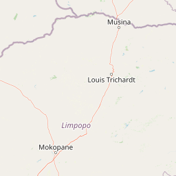
Map view of Waterberg Biosphere

Use this park location map to pinpoint Waterberg Biosphere in South Africa, understand its exact geographic position, and read its mapped placement within the surrounding landscape more clearly.

Pigeon | © OpenStreetMap contributors

Location context for Waterberg Biosphere

Limpopo
Natural feature types

Analyze the Natural Features and Landforms of the Waterberg Biosphere

Continue your geographic exploration by examining the natural features and geological landforms of the Waterberg Biosphere. Use these records to understand the structural composition of the massif and the surrounding protected zones, powered by the MoriAtlas mapping system.
Recorded earthquake history

Examine the Recorded Earthquake History for the Waterberg Biosphere

Investigate the historical seismic records associated with the Waterberg Biosphere. This catalogue provided by MoriAtlas allows for the study of past earthquake locations, magnitudes, and depths across this protected sandstone landscape in South Africa.

Waterberg Biosphere Earthquake History

Catalogued events

2 events

Strongest magnitude

Magnitude 4.2

Most recent event

Oct 18, 2019

This history includes earthquakes recorded inside the park or within 50 km of its borders

Explore protected area views, sandstone cliffs, and diverse Bushveld habitats.

Waterberg Biosphere Photos and Landscape Scenery Visual Archive

Visual documentation of Waterberg Biosphere reveals dramatic sandstone mesas, deep river gorges, and rugged cliff terrain. Examining authentic park photography provides clear insight into regional geology, savanna habitats, and protected landscapes.

A high-angle view of a winding river flowing through a rocky, forested canyon with steep cliff walls and dense green vegetation.

An ancient rock painting in dark pigment on a textured, sandy-colored rock surface showing the silhouette of a four-legged animal resembling a small antelope.

Two yellow birds with black heads perched on a tree branch.

Park atlas

Compare adjacent game reserves and regional conservation areas in Limpopo Province

Explore Other Parks Near Waterberg Biosphere and Surrounding Protected Landscapes

Continue geographic comparison by browsing other protected areas located near Waterberg Biosphere. Discovering adjacent reserves reveals how surrounding Bushveld savanna and sandstone terrain connect across the regional ecosystem.
A soft watercolor painting of a river flowing through a hilly, green valley with distant ridgelines under a pale sky.
Nature reserveLimpopo
Mapped location lies within the park boundary#1 closest

Northeast

Lapalala Wilderness Nature Reserve: Geographic Atlas and Park Landscape Mapping

Protected bushveld terrain in the Limpopo province of South Africa

Lapalala Wilderness represents an influential private conservation landscape featuring over forty-eight thousand hectares of bushveld habitat. Gain insight into the reserve's structural diversity, including its sixty kilometers of priority river systems and distinct land types that define this protected territory in Limpopo.

Area
480 km²
Established
1981
Relief
Upland
Climate
Subtropical
National parkLimpopo Province
Park boundaries overlap#2 closest

Southwest

Marakele National Park: National Park Protected Landscape and Geographic Context

Explore its Limpopo Province regional setting and mapped boundaries.

Marakele National Park represents a vital protected national park within the diverse geography of Limpopo Province, South Africa. This entry provides detailed atlas-style information on its protected landscape, focusing on mapped geographic boundaries and its context within the regional natural terrain. It serves as a key resource for understanding the park's specific role as a conservation area and its place within the broader atlas of South African protected lands.

Area
670 km²
Established
1994
Relief
Mountain
Climate
Subtropical
Wildlife reserveLimpopo
Mapped location lies within the park boundary#3 closest

Southwest

Welgevonden Game Reserve: A Comprehensive Geographic Profile of a Limpopo Wildlife Haven

Mapped terrain across the Waterberg mountain bushveld

Welgevonden Game Reserve stands as a focal point for protected land discovery in South Africa. The reserve features complex geological formations, ranging from steep cliffs to open plateau grasslands. Gain insights into the physical boundaries and landscape diversity that define this significant conservation area located within the northern Limpopo province.

Area
382 km²
Relief
Mountain
Access
Access unknown
Scope
Terrestrial
Wildlife reserveLimpopo
About 28 km away#4 closest

South

Mabula Game Reserve: Protected Bushveld and Geographic Landscape Profile

Exploration of the Limpopo bushveld and wildlife habitat boundaries

Mabula Game Reserve provides a detailed look at the bushveld ecosystems of South Africa. Spanning 12,000 hectares in Limpopo, the reserve features a unique blend of rocky ridges, open savanna, and riverine woodlands. Its structural diversity creates a distinct natural corridor that serves as a focal point for understanding regional wildlife distribution and the transition zone between the Waterberg and the northern plains.

Area
120 km²
Scope
Terrestrial
Nature reserveLimpopo Province
34 km away#5 closest

Southeast

Nylsvley Nature Reserve: A Geographical Overview of Limpopo Province's Wetland Landscapes

Protected floodplain ecosystems and seasonal riverine terrain

Nylsvley Nature Reserve protects a vast, shallow floodplain and surrounding open woodland, creating a high-density conservation zone in the Limpopo Province. Its terrain is defined by the seasonal interaction of the Nyl River, extensive reedbeds, and unique botanical communities. This profile examines the reserve as a significant reference point for understanding the interplay between floodplain geography, savanna bushveld, and inland wetland habitats.

Area
40 km²
Established
1998
Relief
Lowland
Access
Access unknown
Nature reserveLimpopo
About 44 km away#6 closest

South

Mabalingwe Nature Reserve: Protected Bushveld Geography and Terrain Analysis

Mapping the Limpopo reserve landscape and habitat features

Examine the 8,800-hectare landscape of Mabalingwe Nature Reserve. From its malaria-free bushveld habitat to its network of seasonal dams and mixed woodland terrain, this entry provides a clear look at the environmental context of this private Limpopo protected area.

Area
88 km²
Established
1989
Relief
Upland
Climate
Subtropical
Nature reserveLimpopo Province
About 46 km away#7 closest

Northeast

Blouberg Nature Reserve: Geographic Map and Protected Landscape Overview in Limpopo, South Africa

Tracing the savanna and mountain transition zones of a northern protected area

Blouberg Nature Reserve offers a distinctive look at the Limpopo landscape, encompassing steep sandstone cliffs, old-growth mountain forest patches, and open baobab-studded plains. This protected area stands as a focal point for understanding the ecological transition between the Soutpansberg range and the Limpopo lowveld. Use this atlas resource to understand the park's internal topography, its specific habitat boundaries, and its regional position as a significant node for raptor conservation in southern Africa.

Area
93.6 km²
Established
1990
Relief
Mountain
Climate
Subtropical
Nature reserveLimpopo
About 67 km away#8 closest

West

Atherstone Nature Reserve: Mapping the Savannah and Bushveld of Limpopo, South Africa

A collaborative conservation landscape of plains and grasslands

Atherstone Nature Reserve features a distinctive blend of classic bushveld thickets and open Kalahari-influenced grasslands. Situated in Limpopo, the 23,500 hectare protected area serves as a primary hub for large mammal conservation and savannah ecology, offering researchers and atlas enthusiasts a focused look at South Africa’s northern provincial wilderness.

Area
235 km²
Established
1994
Relief
Upland
Climate
Subtropical

Common questions about visiting, size, designation, and location context for Waterberg Biosphere

Waterberg Biosphere FAQs for park facts, access, geography, and protected area context

Find quick answers about Waterberg Biosphere, including protected-area facts, park geography, trail and visitor context, and how the park fits into its surrounding country and regional landscape.
MoriAtlas Explorer

Continue Your Protected Areas Search Across the Global Atlas

Deepen your exploration by continuing the structured search for national parks and protected areas worldwide. Utilize the comprehensive filtering capabilities to compare different conservation landscapes and refine your understanding of global park geography. Discover more about the distribution and characteristics of protected natural areas.

Global natural geography