Mori Atlas logo
Nature reserveAkzhayyk Reserve

Exploring the dynamic hydrological interface between freshwater river systems and the Caspian Sea coast

Akzhayyk Reserve: A Protected Wetland Landscape in the Ural River Delta of Kazakhstan

(State Nature Reserve Akzhayyk)

Akzhayyk Reserve protects an essential and shifting mosaic of riverine wetlands, reedbeds, and shallow coastal waters in western Kazakhstan. Centered on the lower Ural River delta where it meets the northern Caspian Sea, this nature reserve serves as a critical stopover for migratory birds along the Siberian-East African flyway. The landscape remains defined by its hydrological dynamism, seasonal flood pulses, and the constant interplay between freshwater channels and the fluctuating shoreline of the world's largest enclosed sea.

wetlandsriver deltaCaspian coastUral Rivermigratory birdsRamsar site

Akzhayyk Reserve

Nature reserve

Park overview

Structured park overview, official facts, and landscape profile for Akzhayyk Reserve

Akzhayyk Reserve park facts, protected area profile, and essential visitor context

Review the core facts for Akzhayyk Reserve, including designation, size, terrain, visitor scale, habitats, and operating context in one park-focused overview.

About Akzhayyk Reserve

Akzhayyk Reserve is a protected natural area in the westernmost lowlands of Kazakhstan, anchored on the final stretch of the Ural River as it enters the Caspian Sea. The reserve corresponds to the broad zone where the river fragments into channels, distributaries, and marshlands before reaching the sea, together with a substantial length of Caspian shoreline and its associated shallow water zone. Together, these environments form one of the most ecologically important wetland complexes in the country.

The protected area was established under direct government authority, responding to the long history of ecological pressure on the Ural delta and the surrounding Caspian coast, including fisheries, oil development in the wider region, and changes in water regulation. Its legal and institutional framework gave the delta its first dedicated conservation designation focused on hydrological regime, migratory species, and shoreline dynamics, rather than on forestry or game management alone.

Ecologically, Akzhayyk represents the transition between freshwater river delta and saline coastal lagoon. Its habitats include reed and cattail beds, floating-leaved and submerged aquatic plant communities, periodically flooded terrestrial margins, and open northern Caspian shallows. This habitat mosaic sustains both resident species and seasonal migrants, and supports sensitive species groups such as sturgeons in the lower river and Caspian seals in the coastal waters. The reserve is therefore understood as much as a living hydrological system as it is a collection of protected habitats.

Quick facts and research context for Akzhayyk Reserve

Akzhayyk Reserve lies in the Mahambet District of Atyrau Region, in western Kazakhstan, and extends onto the lands of the city of Atyrau itself. It was created by Government Resolution No. 119 of 6 February 2009, placing the delta of the Ural River and the adjacent Caspian coast under formal state protection.

The reserve's IUCN category is VI, recognizing the area as a protected landscape under sustainable natural resource use. It is internationally significant as one of only two Ramsar-listed wetlands in Kazakhstan, alongside the Tengiz-Korgalzhyn lake system, and was added to the UNESCO World Network of Biosphere Reserves in 2014.

Protection and recognition

Examine official management scope and documented conservation designations

Akzhayyk Reserve Protection Status and International Recognition Facts

Akzhayyk Reserve maintains a mixed protection scope governed by established management frameworks and administrative records. Comprehensive evaluation details review documented recognition metrics, designation histories, and formal administrative classifications.

Protection details

Protection scope
Mixed
Transboundary protection
No
Park context

Deeper park guide and search-rich context for Akzhayyk Reserve

Akzhayyk Reserve history, landscape, wildlife, and travel context

Explore Akzhayyk Reserve through its history, landscape character, ecosystems, wildlife, conservation priorities, cultural context, and seasonal travel timing in a structured park guide built for atlas discovery and search intent.

Why Akzhayyk Reserve stands out

Akzhayyk is best known for being one of the premier wetland and migratory bird sites in Kazakhstan. The reserve protects a critical segment of the Siberian-East African flyway, where tens of thousands of waterbirds concentrate during seasonal passage, including flamingos, curly pelicans, swans, and the endangered lesser white-fronted goose. The reserve is equally celebrated for its position at the meeting point of the Ural River delta and the Caspian Sea, a dynamic hydrological interface where spring floods, shifting sea levels, and wind-driven surges reshape the landscape. Its combination of Ramsar and UNESCO Biosphere Reserve status places Akzhayyk among the most formally recognized conservation landscapes in the country.
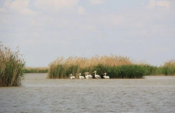
A group of five white pelicans wading in calm water near a patch of tall reeds.
A small group of pelicans in the wetlands of Akzhayyk Reserve.

Akzhayyk Reserve history and protected-area timeline

Akzhayyk Reserve was established by Resolution No. 119 of the Government of the Republic of Kazakhstan, dated 6 February 2009. The decision created a dedicated state institution responsible for the Ural River delta and the adjacent Caspian coastline, recognizing these lands as a distinct ecological unit that warranted formal protection.

Only weeks after the reserve was formally established, the same wetland complex received international recognition. On 1 April 2009, the Ural River delta and the adjoining Caspian coastal zone were inscribed on the List of Wetlands of International Importance, the Ramsar Convention's core register. This made Akzhayyk the second Ramsar site in Kazakhstan, after the Tengiz-Korgalzhyn lake system further east in the country.

The reserve's profile grew further in 2014, when it joined the UNESCO World Network of Biosphere Reserves. This step formalized the area's combined role as a conservation site, a zone of sustainable resource use, and a reference area for long-term environmental monitoring of one of Central Asia's major river deltas and the world's largest enclosed sea.

Akzhayyk Reserve landscape and geographic character

The landscape of Akzhayyk is shaped almost entirely by water. At its core lies the lower Ural River, which after flowing through the city of Atyrau splits into multiple branches and channels before reaching the Caspian Sea. The lower course is deepened each year by the spring flood pulse, producing pools of seven to twenty metres in depth along with shallower stretches. The river is essentially a snow-fed system, with no significant tributaries joining after Oral in the upstream sections.

The delta merges into a broad zone of reed and cattail marshes, floating and submerged aquatic plant communities, and periodically flooded lowlands. Beyond this freshwater belt, the reserve extends onto the shallow northern Caspian coast, where the seabed slopes very gently and the configuration of the shoreline allows large wind-driven fluctuations in water level. Storm surges can shift the effective coastline by several kilometres in moderate conditions and by much greater distances under extreme winds, while set-downs can expose the seabed over wide areas.

The wider climate is strongly continental and notably dry, with hot summers, dust storms, winters with little snow, low annual precipitation, and persistent winds that on average reach five to seven metres per second. This combination of strong seasonality, low rainfall, and persistent wind gives the whole delta and coastal zone a distinctive, ever-shifting character shaped by both river flow and sea level.

Akzhayyk Reserve ecosystems, habitats, and plant life

Vegetation in Akzhayyk is dominated by aquatic and wetland communities, reflecting the permanently and seasonally flooded nature of most of the reserve. Two main types of aquatic vegetation are recognized: a phytobenthic layer of attached submerged macroalgae and higher submerged plants near the bottom, and an air-water layer dominated by emergent hygrophytes such as reed and cattail, together with floating species like water lilies and water chestnut, and submerged species including hornwort and spiked water milfoil.

The reserve's flora includes around 130 recorded species spread across roughly 90 genera and 33 families. This represents about half of the plant diversity documented for the Kazakh portion of the North Caspian region. Among the recorded flora are rare and Red Book-listed plant species, emphasizing the conservation importance of the wetland habitats rather than any arid-land assemblage.

The habitats form an unusually productive ecological interface, where freshwater channels flow into a saline closed sea. The combination of shallow water, dense emergent vegetation, and seasonally shifting shoreline generates high biological productivity, which in turn supports rich communities of invertebrates, fish, and waterbirds, and gives the reserve its character as a continuous wetland-to-coastal ecosystem rather than two separate protected landscapes.

Akzhayyk Reserve wildlife and species highlights

Akzhayyk Reserve is primarily known for its birdlife. The Ural delta and the adjoining Caspian shoreline lie directly along the Siberian-East African migratory flyway, and during seasonal passage the reserve hosts very large concentrations of waterbirds. Among the species documented are several rare breeding or staging birds, including glossy ibis, spoonbill, little egret, cattle egret, and purple swamphen, while flocks of thousands of flamingos, curly pelicans, Mediterranean gulls, and swans use the area as a major stopover. The endangered lesser white-fronted goose is also recorded during migration.

Beyond birds, the reserve supports a mammal fauna of around 78 species, reflecting the diversity of habitats from wetlands and riparian woodlands to drier steppe margins. The coastal and estuarine waters also harbour two particularly significant animal groups: sturgeons in the river and delta, and the Caspian seal in the marine zone, both of which are considered to be on the edge of survival in the wider region. The regional lists of threatened species also include insect and reptile species, underscoring that the conservation interest of Akzhayyk extends well beyond the charismatic migratory birds.

Akzhayyk Reserve conservation status and protection priorities

Akzhayyk is a conservation area of national and international importance, layered with multiple formal designations. At the national level, it is a state nature reserve managed under the authority of the Committee of Forestry and Animal World of the Ministry of Agriculture of Kazakhstan, with IUCN category VI recognizing a role in sustainable natural resource use rather than strict wilderness protection.

Internationally, the reserve carries two of the most significant wetland and biodiversity labels available. Its inscription as a Ramsar site in 2009 brought global recognition of its value for waterbirds and hydrological function, while its 2014 inclusion in the UNESCO World Network of Biosphere Reserves positioned it as a reference site for long-term study of the Ural delta and the Caspian coast.

The area's conservation value extends beyond bird protection. The reserve covers important sturgeon habitats, and the Caspian seal depends on the coastal waters it includes. By bringing river, delta, and sea within a single protected framework, Akzhayyk plays a central role in Kazakhstan's strategy for safeguarding the ecological connectivity of one of the country's major river systems and the most biologically productive zone of the Caspian.

Top sights and standout views in Akzhayyk Reserve

Akzhayyk Reserve combines the delta of one of Eurasia's major rivers with the shoreline of the world's largest enclosed sea, creating a continuously shifting wetland-to-coast landscape. Its formal protections at both national and international level place it among the most fully designated wetland sites in Kazakhstan, and its position on a major migratory flyway gives it outstanding seasonal wildlife interest.

What distinguishes Akzhayyk from many other steppe and desert reserves in the region is the depth of its water-associated identity: the reserve is shaped by river flow, by sea level change, and by wind-driven surges, and its conservation significance is inseparable from this hydrological dynamism. The presence of sturgeons, Caspian seals, and major waterbird concentrations gives it a rare combination of freshwater, marine, and migratory values within a single management framework.

Best time to visit Akzhayyk Reserve

The character of a visit to Akzhayyk depends strongly on seasonal hydrology. Spring is the period of most dramatic change in the landscape, when the Ural River enters its spring flood pulse, levels rise several metres above the summer baseflow, and the delta is reworked by fresh water and sediment. Late spring and early summer, near the peak of the flood, are likely to offer the richest combination of flooded wetlands and high waterbird activity, although weather can be changeable.

Summer brings hot, dry conditions and strong winds, including dust storms, with generally low humidity and very limited rainfall. Autumn is the most important season for waterbird passage and is also the period with the highest frequency of wind-driven sea surges along the Caspian coast, which can dramatically alter the apparent shoreline. Winter is cold, windy, and often marked by thaws and little snow, producing subdued scenery but occasionally interesting concentrations of wintering waterfowl.

Monthly climate preview

Long-term representative point measurements tracking twelve-month thermal and precipitation cycles

Akzhayyk Reserve Climate Normals and Measured Annual Temperature Patterns

Akzhayyk Reserve records documented long-term monthly temperatures ranging from sub-zero winter minimums to warm summer highs alongside measured precipitation rates. Reviewing the complete twelve-month climate profile provides detailed historical baseline data for thermal and moisture patterns across the protected landscape.
Annual mean10 °C
-6 °C28 °C
Jan-6°
Feb-6°
Mar
Apr11°
May19°
Jun25°
Jul28°
Aug26°
Sep19°
Oct10°
Nov
Dec-3°
Warmest month
July

27.9 °C

Coolest month
January

-6.3 °C

Wettest month
May

0.9 mm/day

Driest month
August

0.3 mm/day

Park location guide

Geography guide, regional context, and park location map for Akzhayyk Reserve

Akzhayyk Reserve park geography, regions, and map view in Kazakhstan

Understand where Akzhayyk Reserve sits in Kazakhstan through a broader geographic reading of the surrounding landscape, nearby location context, and its mapped position within the national park landscape.

How Akzhayyk Reserve fits into Kazakhstan

Kazakhstan is a Central Asian country spanning vast steppes and plains, bordered by Russia, China, Kyrgyzstan, Uzbekistan, and Turkmenistan, with a coastline along the Caspian Sea. It gained independence from the Soviet Union in 1991 and has a population of approximately 20.5 million people. The country is officially secular but predominantly Muslim, with Kazakh and Russian as official languages.

Wider geography shaping Akzhayyk Reserve in Kazakhstan

Kazakhstan occupies a vast territory in Central Asia, extending into Eastern Europe. Its terrain consists largely of hilly plateaus and plains, with lowlands covering about a third of the area. The southern and eastern regions are mountainous. The country borders Russia to the north and west, China to the east, Kyrgyzstan to the southeast, Uzbekistan to the south, and Turkmenistan to the southwest. It has a coastline along the Caspian Sea.

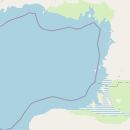
Map view of Akzhayyk Reserve

Use this park location map to pinpoint Akzhayyk Reserve in Kazakhstan, understand its exact geographic position, and read its mapped placement within the surrounding landscape more clearly.

Pigeon | © OpenStreetMap contributors

Visual exploration of riverine wetlands, reed marshes, and Caspian coast environments.

Akzhayyk Reserve Landscape and Scenery Photography

Visual documentation of Akzhayyk Reserve reveals the complex geography of the lower Ural River delta and the northern Caspian shoreline. Examining protected area imagery provides deeper insight into shifting hydrological landscapes, seasonal habitats, and expansive wetland ecosystems.

A group of five white pelicans wading in calm water near a patch of tall reeds.

A group of five white pelicans standing in shallow water in front of a tall thicket of green and brown reeds under a pale sky.

Park atlas

Compare surrounding wetland reserves and regional conservation areas in western Kazakhstan

Parks Near Akzhayyk Reserve and Related Protected Landscapes to Explore Next

Discover other parks and protected areas sharing the wider ecological context of Akzhayyk Reserve. Comparing adjacent wetland complexes and regional habitats provides deeper perspective on the river deltas and coastal landscapes of western Kazakhstan.
Wildlife reserveWest Kazakhstan Region
About 268 km away#1 closest

North

Zhaltyrkol Sanctuary: A Wildlife Reserve in the West Kazakhstan Steppe Mosaic

Mapping wetland habitats along the Kushum and Ural River basins.

Zhaltyrkol Sanctuary encompasses a unique steppe-and-wetland mosaic, featuring shallow lakes such as Zhaltyrkol and Itbatyr. It provides a protected habitat for waterfowl and game species, maintaining essential breeding grounds within the flat, open terrain of the West Kazakhstan Region.

Area
190 km²
Established
1967
IUCN
IV
Relief
Lowland
A horizontal watercolor painting showing a pale, soft-focus landscape with rolling green plains, a few small trees, and layered distant hills in shades of light purple and pink.
Nature reserveWest Kazakhstan Region
About 401 km away#2 closest

Northwest

Bokeyorda Nature Reserve: Mapping Protected Steppe Landscapes in West Kazakhstan

A regional stronghold for migratory saiga antelope populations

Bokeyorda Nature Reserve serves as a foundational protected area in the West Kazakhstan Region, established to preserve expansive dry steppe and semi-desert environments. The reserve provides essential habitat for migratory ungulates, forming a connected conservation corridor alongside the Ashchiozek Sanctuary that spans diverse lowland terrain and seasonal water features within the northwestern Kazakh plains.

Area
3,430.4 km²
Established
2022
IUCN
VI
Relief
Lowland
A horizontal watercolor painting showing a stylized, layered landscape of rolling green hills, a calm river, and hints of forest, rendered in soft pastel tones against a white background.
Wildlife reserveWest Kazakhstan Region
About 499 km away#3 closest

North

Kirsanov Sanctuary: Protected Floodplain Landscapes and Ural River Geography

Wildlife reserve and riverine corridor in West Kazakhstan

Spanning 50 kilometers along the Ural River, Kirsanov Sanctuary preserves a rich mix of floodplain meadows, gallery forests, and oxbow lakes. Originally established for beaver conservation, this wildlife reserve now functions as a complex ecosystem refuge, representing a key protected landscape within the West Kazakhstan regional geography.

Area
610 km²
Established
1967
IUCN
IV
Relief
Lowland
A horizontal watercolor painting showing a soft, stylized landscape with rolling hills, distant mountains, forested areas, and a meandering stream or marshy foreground.
National parkSaratov Oblast
About 559 km away#4 closest

Northwest

Dyakovsky Forest National Park: Protected Forest Landscapes and Steppe Geography in Saratov Oblast

A rare woodland island mapping project in the Russian Trans Volga region.

Dyakovsky Forest National Park stands as a significant natural monument in Saratov Oblast, preserving a rare mosaic of forest patches on sand-plain terraces. As the southernmost natural forest massif in Europe, it provides an essential study in ecological resilience, where woodland habitats thrive against the backdrop of the extensive Eurasian steppe. The territory features a complex interplay of riverine environments, oak groves, and psammophyte vegetation.

Area
185.32 km²
Established
2023
Relief
Lowland
Climate
Arid
National parkDagestan
About 622 km away#5 closest

Southwest

Samursky National Park: National Park Protected Landscape and Geographic Atlas

Explore Dagestan's Samursky National Park mapped terrain.

Gain a structured understanding of Samursky National Park, a key national park within Russia's Dagestan region. This page focuses on its protected landscape identity, mapped boundaries, and its place within the regional geography of the North Caucasus. Use this atlas-centric view to comprehend the park's contribution to Dagestan's natural terrain and conservation landscape.

Area
483 km²
Established
2019
IUCN
II
Relief
Mixed relief
National parkKhachmaz Rayon
About 626 km away#6 closest

Southwest

Samur-Yalama National Park: Caspian Coastal Forest Protected Area

Mapped protected landscape in Azerbaijan's Khachmaz Rayon.

Delve into the protected geography of Samur-Yalama National Park, a key national park established in 2012 within Azerbaijan's Khachmaz Rayon. This 11,772-hectare area meticulously preserves vital Caspian coastal forest ecosystems, characterized by dominant chestnut oak and Persian ironwood stands. The park’s diverse terrain ranges from littoral zones to inland steppe, offering significant insights into regional landscape context and protected area management for atlas exploration and geographic analysis.

Area
117.72 km²
Established
2012
IUCN
II
Relief
Mixed relief
Watercolor illustration of green hills, a body of water, and pink and yellow vegetation
National parkSaratov Oblast
About 667 km away#7 closest

North

Khvalynsky National Park: Protected Landscape and Regional Geography Atlas

Discover mapped park boundaries in Saratov Oblast

Khvalynsky National Park is a significant protected area designated as a national park within the Saratov Oblast. This entry provides detailed atlas-based insights into its geographic scope, protected landscape features, and its context within the wider regional geography of Southeastern European Russia. Explore the mapped terrain and understand how this park contributes to the conservation landscape of the Volga region.

Area
255 km²
Established
1994
IUCN
II
Visitors
35K annual
National parkRussia
About 672 km away#8 closest

North

Buzuluksky Bor National Park: Mapping an Isolated Forest in the Russian Steppe

Examining the unique geomorphology and forest-steppe ecological boundaries.

Buzuluksky Bor National Park serves as an extraordinary natural laboratory in Russia, defined by its 106,000 hectares of pine forest set against a backdrop of open grasslands. This protected area features deep sandy substrates of marine origin, undulating dune landscapes, and the deeply incised Borovka River valley, providing a vital study site for forest-steppe dynamics and long-term conservation research.

Area
1,060 km²
Established
2007
IUCN
II
Relief
Lowland

Common questions about visiting, size, designation, and location context for Akzhayyk Reserve

Akzhayyk Reserve FAQs for park facts, access, geography, and protected area context

Find quick answers about Akzhayyk Reserve, including protected-area facts, park geography, trail and visitor context, and how the park fits into its surrounding country and regional landscape.
MoriAtlas Explorer

Continue Your Protected Areas Search Across the Global Atlas

Deepen your exploration by continuing the structured search for national parks and protected areas worldwide. Utilize the comprehensive filtering capabilities to compare different conservation landscapes and refine your understanding of global park geography. Discover more about the distribution and characteristics of protected natural areas.

Global natural geography