

Mori Atlas logo
Protected areaAnindilyakwa Indigenous Protected Area

Mapping the island archipelago and marine habitats of this Northern Territory conservation estate

Anindilyakwa Indigenous Protected Area: A Comprehensive Geographic and Landscape Analysis

The Anindilyakwa Indigenous Protected Area spans a vast, ecologically intact archipelago in the western Gulf of Carpentaria, Northern Territory. This protected landscape encompasses Groote Eylandt and Bickerton Island alongside expansive sea Country, featuring a diverse mosaic of mangrove systems, tropical woodlands, and reef environments. Discover the geography and environmental structure of this model for Indigenous-led conservation and marine stewardship.

Indigenous Protected Areaisland archipelagoAboriginal land managementsea countrytropical woodlandmangrove systems

Anindilyakwa Indigenous Protected Area

Protected area

Park overview

Structured park overview, official facts, and landscape profile for Anindilyakwa Indigenous Protected Area

Anindilyakwa Indigenous Protected Area park facts, protected area profile, and essential visitor context

Review the core facts for Anindilyakwa Indigenous Protected Area, including designation, size, terrain, visitor scale, habitats, and operating context in one park-focused overview.

About Anindilyakwa Indigenous Protected Area

The Anindilyakwa Indigenous Protected Area is a regionally significant conservation landscape in the Northern Territory of Australia, defined as much by its Aboriginal cultural management as by its biological richness. Situated roughly 50 kilometres off the eastern coast of Arnhem Land, the IPA centres on Groote Eylandt, Australia's second largest island, along with Bickerton Island and numerous smaller islands and coastal waters that together form a wide archipelago within the Gulf of Carpentaria region.

The protected area was formally established through a partnership between the Anindilyakwa Land Council and the Australian Government, with ongoing management resting with Anindilyakwa traditional owners and the Anindilyakwa Land and Sea Rangers. This governance arrangement places Aboriginal decision-making at the core of conservation practice, allowing ecological management to be guided by cultural law, traditional knowledge, and contemporary land management goals. In 2016, traditional owners extended the IPA into adjacent sea Country, more than doubling the area under Indigenous stewardship.

The Anindilyakwa IPA stands out for the unusually high ecological integrity of its landscapes. There is no history of Western agriculture in much of the area, and pressures from introduced species remain comparatively limited. The result is a relatively pristine setting of tropical woodland, coastal vegetation, mangrove systems, and offshore reefs and shoals. These environments support a wide variety of terrestrial, freshwater, and marine life, and the IPA is regarded as an important refugium for several threatened species that have declined elsewhere across northern Australia. The area's islands and waters are also integral to Anindilyakwa cultural identity, holding continuing songline routes, traditional sites, and ongoing cultural use.

Quick facts and research context for Anindilyakwa Indigenous Protected Area

The Anindilyakwa Indigenous Protected Area covers approximately 10,000 square kilometres of land and sea Country off the eastern coast of Arnhem Land in the Northern Territory, about 630 kilometres from Darwin. It has been managed by the Anindilyakwa Land Council since 2006 and includes the Groote Eylandt archipelago and adjacent waters.

The region supports over 900 plant species, around 150 marine species, and at least 330 terrestrial vertebrate species, including threatened mammals and four threatened marine turtle species. It is recognised for its high ecological integrity, its Aboriginal cultural landscape, and its role within Australia's National Reserve System as one of the largest Indigenous-managed protected areas in the country.

Protection and recognition

Examine the documented conservation scope and regulatory framework of Anindilyakwa Indigenous Protected Area.

Anindilyakwa Indigenous Protected Area Protection Status and Recognition

Comprehensive protected area records detail the mixed management scope and international recognition status associated with Anindilyakwa Indigenous Protected Area. Formal conservation data highlights the documented regulatory framework and administrative oversight governing the landscape.

Protection details

Protection scope
Mixed
Transboundary protection
No
Park context

Deeper park guide and search-rich context for Anindilyakwa Indigenous Protected Area

Anindilyakwa Indigenous Protected Area history, landscape, wildlife, and travel context

Explore Anindilyakwa Indigenous Protected Area through its history, landscape character, ecosystems, wildlife, conservation priorities, cultural context, and seasonal travel timing in a structured park guide built for atlas discovery and search intent.

Why Anindilyakwa Indigenous Protected Area stands out

The Anindilyakwa IPA is best known for being one of Australia's largest Indigenous-led protected areas, combining a remote tropical island archipelago with extensive sea Country and a deeply intact cultural landscape. It is recognised for its high biodiversity, including the only known population of the northern hopping mouse, important habitat for the northern quoll and brush-tailed rabbit rat, and significant breeding grounds for threatened marine turtles. Equally central to its identity is the Anindilyakwa people's custodial relationship with the land and sea, expressed through songlines, traditional sites, and a ranger program that extends across both terrestrial and marine environments. The IPA's combination of Aboriginal land management, ecological research partnerships, and extensive sea country makes it a flagship example of Indigenous Protected Areas in northern Australia.
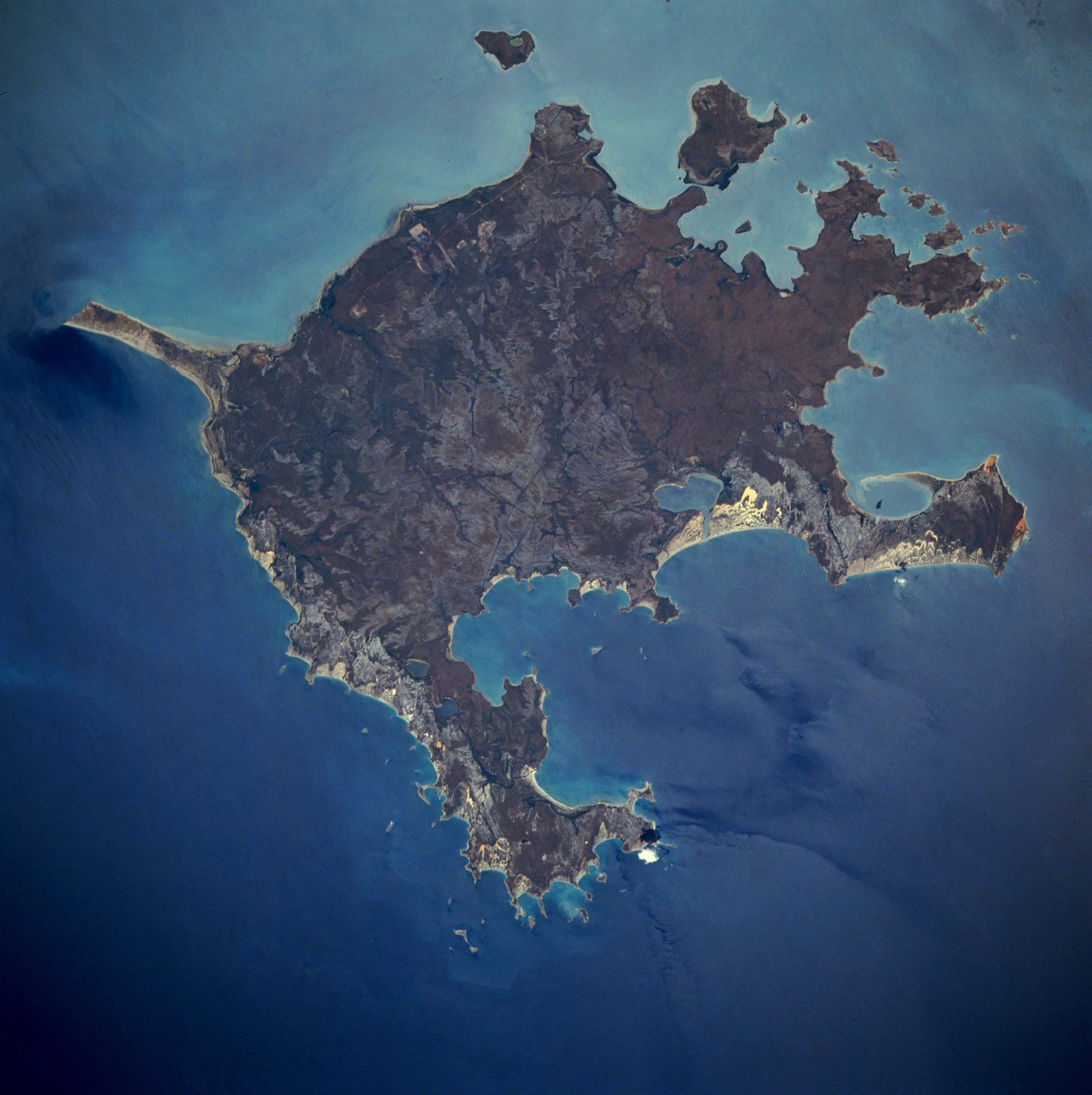
Top-down satellite view of Groote Eylandt surrounded by dark blue ocean water.
An aerial satellite view of Groote Eylandt, the largest island within the Anindilyakwa Indigenous Protected Area.

Anindilyakwa Indigenous Protected Area history and protected-area timeline

The Anindilyakwa Indigenous Protected Area was formally established on 10 June 2006, when the Anindilyakwa Land Council entered into a voluntary agreement with the Australian Government to manage lands belonging to the Anindilyakwa people for conservation and cultural outcomes. This structure placed the IPA within Australia's National Reserve System, recognising Indigenous-led management as a formal component of the nation's protected-area framework.

In 2016, the Anindilyakwa traditional owners extended the protected area significantly, adding approximately 7,000 square kilometres of surrounding sea Country referred to as Makarda. This expansion created one of the more substantial Indigenous-managed sea country estates in northern Australia and was accompanied by the development of the Anindilyakwa IPA Plan of Management 2016, which guides ongoing stewardship priorities.

In 2019, the Anindilyakwa Land Council undertook a major marine research collaboration with the Australian Institute of Marine Science, mapping roughly 3,200 square kilometres of the deeper coastal habitats around Groote Eylandt. The survey produced a detailed baseline dataset intended to support future management decisions on sea Country, and it stands as one of the largest marine habitat mapping efforts of its kind undertaken alongside an Indigenous Protected Area in Australia.

Anindilyakwa Indigenous Protected Area landscape and geographic character

The Anindilyakwa IPA occupies an island-dominated landscape set within the warm tropical waters of the western Gulf of Carpentaria. Groote Eylandt, the principal landmass in the protected area, is a roughly triangular island of gently undulating terrain, fringed by mangroves, rugged sandstone outcrops, beaches, and small inland hills. Bickerton Island, connected to Groote Eylandt at low tide by a shallow sandbar, contributes additional coastline, low woodland ridges, and sheltered bays.

Surrounding these islands is an extensive seascape of shallow coastal waters, tidal flats, reef systems, and deeper marine environments that together form the Makarda sea Country added to the IPA in 2016. The transition zones between mangrove-lined shores and offshore reefs create a mosaic of intertidal and subtidal habitats, while the relatively low and forested interiors of the islands contrast with the open oceanic exposures along their margins.

Across the IPA, the landscape retains an unusually undisturbed character. The absence of broad-scale Western agriculture and limited feral species pressure contribute to a setting where native vegetation patterns, coastal processes, and sedimentary systems function largely without the modifications seen across many other parts of northern Australia. This gives the IPA a strong visual identity defined by clean coastal vistas, intact mangroves, and forest-covered island interiors.

Anindilyakwa Indigenous Protected Area ecosystems, habitats, and plant life

Ecologically, the Anindilyakwa IPA sits within the transition zone between tropical savanna woodland and mangrove-fringed coastal systems typical of the Gulf of Carpentaria. The islands carry a mix of open eucalypt woodland, monsoon vine forest patches, heath, and extensive mangrove cover along tidal reaches, while inland areas include sandy plains, low hills, and seasonal freshwater habitats that support a wide variety of plant and animal communities.

The marine environment is equally important to the IPA's ecological identity. Shallow coastal waters, seagrass beds, fringing reefs, and deeper offshore habitats together support a rich diversity of marine life. These systems function as productive feeding and breeding grounds for fish, marine mammals, seabirds, and several species of marine turtle. The combination of intact terrestrial vegetation, healthy mangrove systems, and connected sea Country gives the IPA an unusually complete ecological profile for the region.

Biodiversity surveys have documented more than 900 plant species within the IPA, alongside roughly 150 marine species and at least 330 terrestrial vertebrate species. Many of these species are of regional or national conservation concern, and the IPA's ecological integrity means it serves as an important source area for biodiversity across the wider Arnhem Land and Gulf of Carpentaria region.

Anindilyakwa Indigenous Protected Area wildlife and species highlights

Wildlife is a defining feature of the Anindilyakwa IPA, with the protected area serving as habitat for several species of conservation significance. The IPA is internationally notable for supporting the only known population of the northern hopping mouse, a small native mammal that has become extremely rare elsewhere in its former range.

The islands and mainland-connected habitats also provide important refuge for the northern quoll, a small carnivorous marsupial that has declined sharply across much of northern Australia, and for the brush-tailed rabbit rat, another threatened native rodent. The persistence of these mammals in the Anindilyakwa IPA is closely linked to the area's limited history of invasive species and the absence of intensive land modification.

Marine wildlife is equally prominent. The IPA's coastal and offshore waters include important breeding habitat for four threatened species of marine turtle, supporting nesting beaches and foraging areas across the island chain. Seabirds, shorebirds, and a wide variety of reef-associated fish species further contribute to the protected area's wildlife profile, with surveys recording approximately 150 marine species in total.

Anindilyakwa Indigenous Protected Area conservation status and protection priorities

The Anindilyakwa IPA plays a significant role in Australia's conservation framework as one of the larger Indigenous Protected Areas contributing to the National Reserve System. Its establishment reflects a national shift toward recognising Aboriginal land and sea management as a legitimate and effective form of conservation, rather than a fallback where conventional reserves are unavailable.

A core conservation strength of the IPA is the integration of cultural governance with biodiversity outcomes. The Anindilyakwa Land and Sea Rangers implement management actions on the ground, guided by the 2016 Plan of Management and supported by partnerships with scientific institutions. The 2019 habitat mapping project with the Australian Institute of Marine Science created a large-scale baseline dataset for marine habitats around Groote Eylandt, providing a reference point for monitoring future change and informing management of sea Country.

The IPA's relatively low exposure to invasive species, absence of broad-scale Western agriculture, and intact vegetation cover mean that the area functions as a stable refugium for regionally threatened wildlife. This combination of ecological intactness and Aboriginal-led management makes the IPA a working example of how cultural objectives and biodiversity conservation can reinforce one another across a large and complex landscape.

Anindilyakwa Indigenous Protected Area cultural meaning and human context

The Anindilyakwa IPA is shaped directly by the continuing cultural relationship between the Anindilyakwa people and their land and sea Country. The archipelago of Groote Eylandt, Bickerton Island, and surrounding waters is home to communities that maintain ancestral connections to the landscape, expressed through songlines, named sites, traditional ecological knowledge, and ongoing cultural practices tied to specific places and species.

The protected area is not simply a conservation zone but an expression of Anindilyakwa law and custodianship. Traditional owners retain authority over land use, while the Anindilyakwa Land Council and Anindilyakwa Land and Sea Rangers translate cultural priorities into day-to-day land and sea management. This includes protecting culturally significant sites, maintaining traditional harvesting practices, and ensuring that ecological work aligns with cultural values.

By formally recognising and supporting these cultural responsibilities, the IPA framework allows the Anindilyakwa people to care for Country in ways that sustain both biodiversity and cultural continuity. The result is a protected area whose identity cannot be separated from the people who manage it, and whose cultural landscape is treated as an integral part of conservation outcome.

Top sights and standout views in Anindilyakwa Indigenous Protected Area

The Anindilyakwa IPA is distinguished by the scale and coherence of its Aboriginal-led management, with approximately 10,000 square kilometres of island and sea Country under traditional-owner stewardship. Its combination of intact terrestrial habitats, mangrove systems, and offshore reefs creates a functional ecological gradient rarely found in such unmodified condition elsewhere in northern Australia.

The protected area's biodiversity profile is unusually rich, featuring the only known population of the northern hopping mouse and important populations of the northern quoll and brush-tailed rabbit rat. Its coastal waters support breeding habitat for four threatened marine turtle species, while the IPA's 2019 marine habitat mapping partnership provided one of the most comprehensive ecological baselines for Groote Eylandt's sea Country.

Equally significant is the IPA's cultural depth. Songlines, traditional sites, and ongoing Anindilyakwa custodianship give the protected area a layered identity that links ecological management to ancestral responsibility, positioning the Anindilyakwa IPA as both a conservation estate and a living cultural landscape.

Best time to visit Anindilyakwa Indigenous Protected Area

The climate of the Anindilyakwa IPA is tropical monsoonal, with a distinct dry season and a wet season that strongly shapes accessibility, atmosphere, and wildlife activity. The dry season, broadly spanning the southern hemisphere winter months, typically brings lower humidity, calmer seas, and more comfortable conditions for outdoor exploration. Vegetation is less dense, skies are generally clearer, and many terrestrial species are more visible as they concentrate around remaining water sources.

The wet season brings higher rainfall, higher humidity, and the possibility of tropical storms, which can limit access and create more challenging conditions on land and sea. However, this period is ecologically significant, with marine productivity often peaking as nutrient-rich waters support rich feeding conditions for fish and marine turtles, while vegetation flourishes across the islands.

There is no single universally ideal period, as the character of the experience shifts meaningfully with the seasons. Visitors with an interest in clearer coastal conditions and easier land travel may favour drier months, while those interested in peak marine productivity and lush tropical landscapes may find the wet season compelling despite its logistical complexity.

Monthly climate preview

Long-term monthly temperature and precipitation rhythms recorded across the protected landscape

Anindilyakwa Indigenous Protected Area Climate Normals and Annual Temperature Patterns

Representative coordinates document sustained monthly temperature variation alongside distinct precipitation rhythms across the protected landscape. Detailed monthly climate normals provide comprehensive baseline statistics for studying long-term environmental patterns.
Annual mean27 °C
24 °C30 °C
Jan29°
Feb29°
Mar29°
Apr28°
May27°
Jun25°
Jul24°
Aug24°
Sep26°
Oct28°
Nov30°
Dec30°
Warmest month
December

29.8 °C

Coolest month
July

23.7 °C

Wettest month
February

8.4 mm/day

Driest month
August

0.1 mm/day

Park location guide

Geography guide, regional context, and park location map for Anindilyakwa Indigenous Protected Area

Anindilyakwa Indigenous Protected Area park geography, regions, and map view in Australia

Understand where Anindilyakwa Indigenous Protected Area sits in Australia through a broader geographic reading of the surrounding landscape, nearby location context, and its mapped position within the national park landscape.

How Anindilyakwa Indigenous Protected Area fits into Australia

Australia is a constitutional monarchy and federal parliamentary democracy comprising six states and ten territories. With a population of nearly 28 million, it is one of the world's most urbanised countries, with most people concentrated on the eastern seaboard. The country has a high Human Development Index and is known for its cultural diversity, ancient Aboriginal heritage, and unique wildlife.

Wider geography shaping Anindilyakwa Indigenous Protected Area in Australia

Australia occupies the entire Australian continent, the island of Tasmania, and numerous smaller islands. It is the world's flattest and driest inhabited continent, featuring vast deserts in the interior (the Outback), tropical rainforests along the eastern coast, and a coastline bordering the Indian and Pacific Oceans.

Map view of Anindilyakwa Indigenous Protected Area

Use this park location map to pinpoint Anindilyakwa Indigenous Protected Area in Australia, understand its exact geographic position, and read its mapped placement within the surrounding landscape more clearly.

Pigeon | © OpenStreetMap contributors

Location context for Anindilyakwa Indigenous Protected Area

Northern Territory

Visualizing tropical archipelagos, marine waters, and undisturbed habitats

Anindilyakwa Indigenous Protected Area Photos and Island Landscapes

Visual records reveal the diverse terrain, mangrove fringes, and coastal waters defining Anindilyakwa Indigenous Protected Area. Studying these protected landscapes provides direct insight into remote island ecosystems and traditional management across northern Australia.

Top-down satellite view of Groote Eylandt surrounded by dark blue ocean water.

Park atlas

Compare regional geography and connected marine conservation areas across northern Australia

Explore Parks Near Anindilyakwa Indigenous Protected Area and Surrounding Protected Landscapes

Browse other protected areas and tropical island reserves located near Anindilyakwa Indigenous Protected Area. Compare regional park geography and coastal conservation landscapes across the surrounding northern Australian region.
National parkNorthern Territory
About 132 km away#1 closest

Southwest

Limmen National Park: Explore Australia's Northern Territory National Park & Protected Landscape

Discover mapped geography and regional context for this protected area.

Limmen National Park stands as a distinct protected area within the Northern Territory, offering valuable insights for geographic exploration. This national park serves as a focal point for understanding the mapped landscape and the broader regional context of protected lands in Northern Australia. Its identity as a national park contributes significantly to the geographic narrative of the territory, making it a crucial point for atlas-based discovery.

Area
9,369.26 km²
Established
2012
IUCN
II
Relief
Upland
Protected areaNorthern Territory
About 172 km away#2 closest

North

Marthakal Indigenous Protected Area: Geographic Overview and Protected Landscapes

Indigenous-managed coastal and inland savanna terrain in the Northern Territory

Marthakal Indigenous Protected Area covers extensive marine and terrestrial environments on Elcho Island, featuring a unique topography that ranges from tropical wetlands and savanna woodlands to rocky shorelines. As a key conservation entity in the Northern Territory, it safeguards critical habitats for threatened species and preserves the geological legacy of an ancient land bridge connecting Australia to Southeast Asia.

Area
3,230 km²
Established
2016
Relief
Lowland
Climate
Tropical
National parkNorthern Territory
About 173 km away#3 closest

South

Barranyi (North Island) National Park: Northern Territory Island Protected Area and Landscape Context

Explore mapped geography and unique island terrain.

Barranyi (North Island) National Park is a remote national park in the Northern Territory, distinguished by its island setting in the Gulf of Carpentaria. The park's landscape features low coastal terrain, beaches, and dune formations, embodying a protected island ecosystem. Discover its mapped boundaries and geographic context within the vast northern Australian region, offering a specific example of island conservation and Indigenous land stewardship.

Area
53.81 km²
Established
1992
IUCN
II
Climate
Tropical
Nature reserveNorthern Territory
About 228 km away#4 closest

West

Wongalara Sanctuary: Protected Landscapes and Top End Geography

Nature reserve featuring sandstone escarpments and savannah woodlands

Wongalara Sanctuary acts as a vital nature reserve and ecological refuge within Australia's Northern Territory. Spanning rugged sandstone plateaus, monsoon rainforests, and seasonal wetlands, the protected area maintains a rare, feral herbivore-free environment that supports extensive biodiversity across its mapped river corridors.

Area
1,910 km²
Established
2007
Relief
Upland
Climate
Tropical
Marine protected areaQueensland
About 272 km away#5 closest

Southeast

Gulf of Carpentaria Marine Park: Mapped Marine Protected Area and Tropical Geography

Submerged reefs, coastal basins, and Queensland marine habitats

The Gulf of Carpentaria Marine Park serves as a crucial protected zone in northern Australia, safeguarding complex marine environments. This atlas entry details its significant geographic features, ranging from productive coastal waters and sedimentary basins to isolated coral reefs. Gain a deeper understanding of the bathymetry and protected boundaries that support high levels of tropical marine biodiversity.

Area
23,771 km²
Established
2018
IUCN
VI
Relief
Lowland
Wildlife reserveNorthern Territory
About 297 km away#6 closest

South

Pungalina-Seven Emu Sanctuary: Protected Wildlife Reserve and Regional Landscape Atlas

Coastal and upland wilderness in the Northern Territory

Uncover the geographic breadth of Pungalina-Seven Emu Sanctuary, an essential wildlife reserve in Australia. The landscape encompasses sandstone gorges, extensive freshwater wetlands, and tidal mudflats, providing a crucial conservation corridor along the Gulf of Carpentaria. This site offers deep insight into the intersection of Indigenous stewardship and professional land management across tropical savanna environments.

Area
3,072.12 km²
Established
2009
IUCN
II
Relief
Upland
National parkNorthern Territory
About 374 km away#7 closest

West

Elsey National Park: Northern Territory National Park Atlas and Protected Landscape Context

Discover the mapped terrain and unique natural features of Elsey National Park.

Elsey National Park, located in Australia's Northern Territory, is a significant protected area known for its distinctive thermal springs and characteristic paperbark woodlands. This national park provides a valuable point of study for understanding regional geography, mapped natural landscapes, and the hydrological importance of its riverine environments, offering a concrete example of protected land within the tropical savanna biome.

Area
138.96 km²
Established
1991
IUCN
II
Visitors
207.7K annual
Nature reserveNorthern Territory
About 376 km away#8 closest

Southwest

Bullwaddy Conservation Reserve: Protected Woodland Geography on the Northern Territory Sturt Plateau

Nature reserve boundary and landscape context

Bullwaddy Conservation Reserve represents an important protected woodland enclave on the Sturt Plateau. The terrain, defined by nutrient-poor lateritic soils, supports dense native thickets that stand out against the backdrop of the surrounding pastoral landscape. This nature reserve provides essential ecological integrity for local species and serves as a significant site for understanding the natural vegetation patterns of the Australian outback.

Area
115.3 km²
Established
2000
IUCN
Ia
Relief
Upland

Common questions about visiting, size, designation, and location context for Anindilyakwa Indigenous Protected Area

Anindilyakwa Indigenous Protected Area FAQs for park facts, access, geography, and protected area context

Find quick answers about Anindilyakwa Indigenous Protected Area, including protected-area facts, park geography, trail and visitor context, and how the park fits into its surrounding country and regional landscape.
MoriAtlas Explorer

Continue Your Protected Areas Search Across the Global Atlas

Deepen your exploration by continuing the structured search for national parks and protected areas worldwide. Utilize the comprehensive filtering capabilities to compare different conservation landscapes and refine your understanding of global park geography. Discover more about the distribution and characteristics of protected natural areas.

Global natural geography