
Mori Atlas logo
Natural monumentÁrea protegida municipal Ecoparque Encantado

Tracing the rugged topography, canyon landscapes, and inter-Andean dry forest fragments of the Sud Chichas region.

Área protegida municipal Ecoparque Encantado: A Natural Monument in the Southern Bolivian Andes

(Área Protegida Municipal Ecoparque Encantado)

Área protegida municipal Ecoparque Encantado stands as a significant natural monument in the Sud Chichas province of Potosí, Bolivia. The protected area features a striking vertical profile defined by steep quebradas, folded ridges, and the iconic erosional walls of Cañón del Duende. As part of the Eastern Cordillera, the landscape preserves a mosaic of prepuna shrublands, puna grasslands, and remnants of dry valley forests that serve as a refuge for regional biodiversity.

inter-Andean dry valleysdry forestprepunapuna grasslandcanyon landscapeAndean condor
A flat-style digital illustration showing a desert canyon with towering red cliffs, a winding blue river, and various cacti under a soft, sunset-colored sky.

Área protegida municipal Ecoparque Encantado

Natural monument

Park overview

Structured park overview, official facts, and landscape profile for Área Protegida Municipal Ecoparque Encantado

Área Protegida Municipal Ecoparque Encantado park facts, protected area profile, and essential visitor context

Review the core facts for Área Protegida Municipal Ecoparque Encantado, including designation, size, terrain, visitor scale, habitats, and operating context in one park-focused overview.

About Área Protegida Municipal Ecoparque Encantado

Área Protegida Municipal Ecoparque Encantado is a relatively young but ecologically meaningful protected area located in the southern Bolivian Andes, near the town of Tupiza. Established in 2015 as a Natural Monument under the municipal government of Tupiza, it has been designed to safeguard a representative cross-section of one of the most distinctive dry-land environments in the country: the deeply dissected transition zone between the Eastern Cordillera ranges of Chichas and Lípez and the deep valleys of the Tupiza and San Juan del Oro rivers.

The area's identity is rooted in its geology and topography. Long-term erosion of folded sedimentary and volcanic formations has carved a complex relief of quebradas, ridges, and canyon-like features, of which the Cañón del Duende is the best-known example. This rugged landscape produces distinct ecological levels, ranging from relatively warm inter-Andean valley environments to cooler prepuna and low puna zones above 3,500 meters. The result is a small but highly heterogeneous protected area where very different microclimates, vegetation types, and wildlife communities come together within a compact territorial frame.

Ecologically, Ecoparque Encantado stands out for protecting a remnant of the inter-Andean dry forests and their associated biodiversity. The vegetation includes elements with Chacoan affinity, alongside high-Andean grasslands, thorn scrub, cactus formations, and locally relic patches of dry woodland with species such as churqui, algarrobo, and molle. Its fauna, although reduced by historical land use pressure, still includes notable species such as the Andean condor, puma, Andean fox, vizcacha, and a number of endemic or range-restricted birds and plants. As a municipal-level initiative, the area also represents a model for local conservation action in a region where habitat fragmentation and degradation have been longstanding concerns.

Quick facts and research context for Área Protegida Municipal Ecoparque Encantado

Ecoparque Encantado is a municipal protected area in Bolivia, established on 19 May 2015 through Ley Municipal 092/2015 by the Autonomous Municipal Government of Tupiza. It is classified as an IUCN Category III Natural Monument, a designation used for sites protecting outstanding natural features of ecological, scenic, or scientific value.

The area covers a relatively compact footprint within the Eastern Cordillera of the Andes, between the Chichas and Lípez ranges, and is administered as part of the municipality of Tupiza in the department of Potosí. Its setting in the southern Bolivian Andes gives it a semi-arid, high-altitude character shaped by deep river valleys and strong altitudinal variation.

Protection and recognition

Documented terrestrial protection scope, management framework, and official designation details

Área protegida municipal Ecoparque Encantado Protection Status and Recognition

Terrestrial protection status records for Área protegida municipal Ecoparque Encantado outline the established management scope and designation framework. Structured conservation facts provide verified administrative context for this protected natural area.

Protection details

Protection scope
Terrestrial
Transboundary protection
No
Park context

Deeper park guide and search-rich context for Área Protegida Municipal Ecoparque Encantado

Área Protegida Municipal Ecoparque Encantado history, landscape, wildlife, and travel context

Explore Área Protegida Municipal Ecoparque Encantado through its history, landscape character, ecosystems, wildlife, conservation priorities, cultural context, and seasonal travel timing in a structured park guide built for atlas discovery and search intent.

Why Área Protegida Municipal Ecoparque Encantado stands out

Ecoparque Encantado is best known for its dramatic inter-Andean dry landscapes, where narrow quebradas, eroded canyon walls, and stepped altitudinal zones produce a striking mosaic of dry valleys, prepuna shrublands, and puna grasslands. The Cañón del Duende is one of the area's signature scenic features and a recognizable symbol of its erosional character. The protected area is also recognized for preserving a remnant of the inter-Andean dry forests and associated flora, including endemic cacti, churqui, algarrobo, and molle, that once extended much more widely through the southern Bolivian Andes. Combined with its birdlife, which includes the Andean condor and several high-altitude specialists, it represents one of the more biodiverse dry-valley refuges in the region.
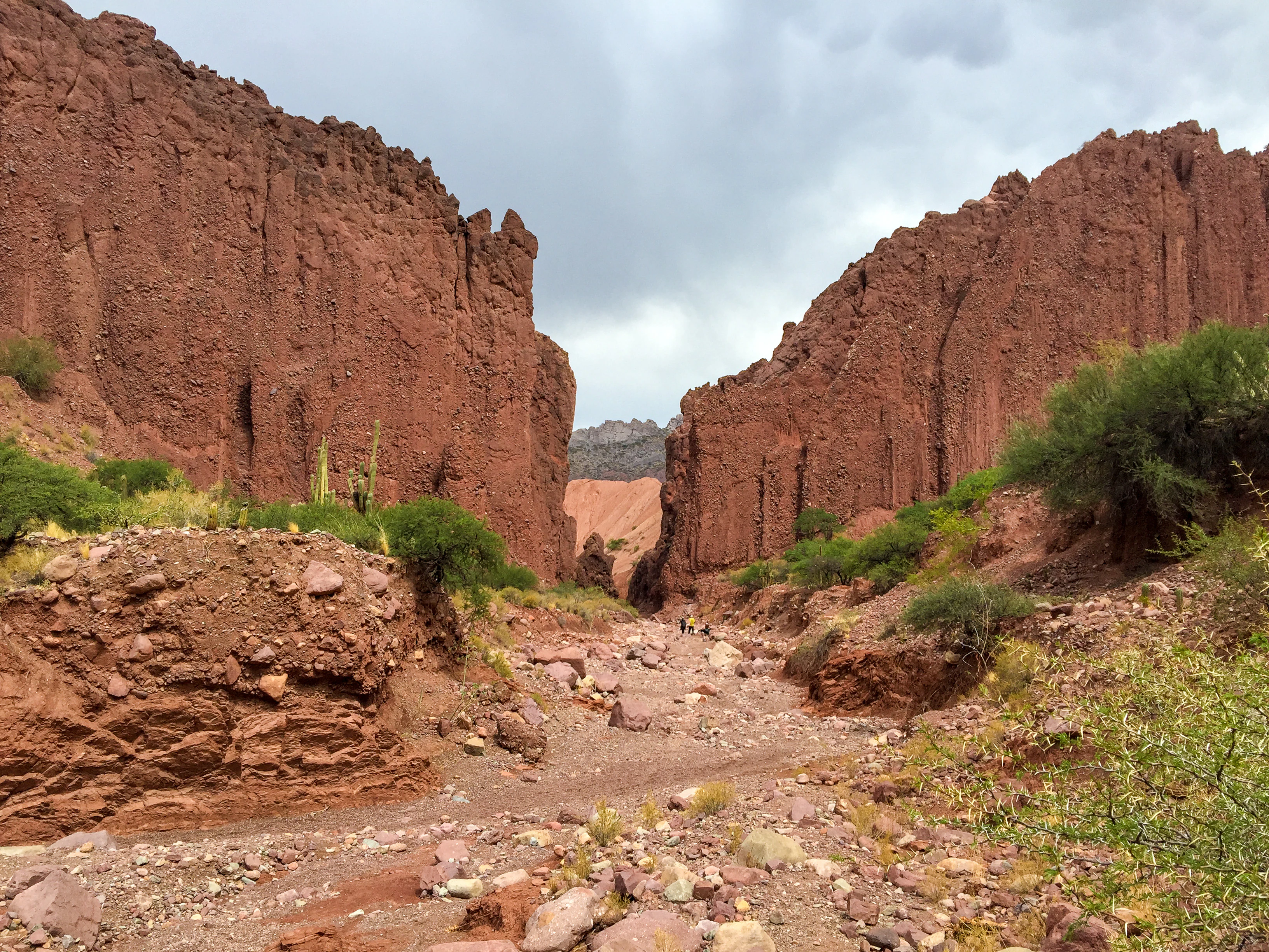
A ground-level view looking into a narrow desert canyon with towering red sandstone walls under a cloudy sky.
The arid red rock landscape of Duende Canyon near Tupiza, Bolivia.

Área Protegida Municipal Ecoparque Encantado history and protected-area timeline

Ecoparque Encantado was officially established as a protected area on 19 May 2015, when the Autonomous Municipal Government of Tupiza promulgated Ley Municipal 092/2015. The law formally designated the area as a Municipal Protected Area, or Área Protegida Municipal, under the category of Natural Monument.

This designation corresponds to IUCN Category III, a classification specifically intended to protect individual natural features of outstanding ecological, scenic, or scientific value, such as notable landforms, canyons, or vegetation communities. The creation of the protected area reflects the municipality's recognition of the ecological and landscape significance of the dry-valley and canyon systems surrounding Tupiza, and of the need to anchor their conservation within a formal legal framework at the local level.

Área Protegida Municipal Ecoparque Encantado landscape and geographic character

The landscape of Ecoparque Encantado is defined by the rugged transition between the Eastern Cordillera of the Andes and the deep inter-Andean valleys of the Tupiza and San Juan del Oro rivers. The area sits on the western flank of the cordillera, between the Chichas and Lípez ranges, an arrangement that produces a strongly dissected topography of folded ridges, slopes, quebradas, and steep-sided valleys.

Cañón del Duende, located along the eastern edge of the protected area, is one of the most representative landscape features and exemplifies the erosional dynamic that shapes the region. Altitudinal variation is significant, ranging from inter-Andean valley environments near 2,950 meters to prepuna and low puna settings above 3,500 meters, creating a stepped vertical profile that influences both climate and vegetation.

Underlying geology plays a major role in the visual character of the area. The landscape is built on a mix of Lower Ordovician sedimentary rocks, Cretaceous and Tertiary sediments, Quaternary fluvial and piedmont deposits, and Tertiary igneous intrusions. Reddish polymictic conglomerates of the Tupiza Formation, together with later terrace and pluvial deposits, contribute to the warm-toned canyon walls and valley floors that give the area much of its visual identity.

Área Protegida Municipal Ecoparque Encantado ecosystems, habitats, and plant life

Ecologically, Ecoparque Encantado sits at the interface between inter-Andean dry valleys, the prepuna, and the lower reaches of the Andean puna. Its location in the rain shadow of the central Andes, combined with the influence of dry winds from the Altiplano, produces an arid to semi-arid setting where vegetation patterns are strongly controlled by altitude, slope exposure, and access to underground or seasonal water.

The vegetation is organized into several distinct formations. These include high-Andean pajonales, xerophytic and semi-humid puna shrublands and grasslands, prepuna matorrales, and valley-bottom communities with denser woody cover. Botanical surveys have documented at least 45 plant families, with Asteraceae, Cactaceae, Fabaceae, Poaceae, and Bromeliaceae among the most diverse, and a notable presence of endemic species associated with the relatively recent uplift of the central Andes.

A distinctive ecological feature of the area is the presence of plant communities with Chacoan floristic affinity, mixed with elements typical of high-Andean ecosystems and even Tucumano-Bolivian influences. This combination produces a vegetation mosaic of considerable biological interest, particularly given that the original dry forests of the southern Bolivian Andes have been severely reduced and fragmented by agriculture, fuelwood harvesting, charcoal production, and urban expansion.

Área Protegida Municipal Ecoparque Encantado wildlife and species highlights

The wildlife of Ecoparque Encantado reflects the mosaic of dry valley, prepuna, and low puna habitats that the area protects, although decades of habitat pressure have left the fauna more reduced and patchy than the vegetation diversity would suggest. Surveys coordinated through the Centro de Interpretación Green Planet and related fieldwork have documented at least 65 bird species, 12 mammal species, seven herpetofauna species, and roughly 43 insect species within and around the area.

Mammals include puma, Andean fox, vizcacha, hurón, and zorrino, among others, representing nine families across the recorded range. Many of these species appear in Bolivia's Red Book of Vertebrates, reflecting the fragile conservation status of wildlife in the region. Higher-elevation sectors in particular show signs of faunal emptiness, a pattern associated with habitat fragmentation, loss of movement corridors, and long-standing human pressure.

Birds are the most diverse component of the fauna, with 22 families recorded and the Emberizidae and Tyrannidae standing out for their species richness. Endemic species and threatened species, such as the Andean condor and high-Andean partridges, are among the area's most significant ornithological highlights, particularly in prepuna and mesothermal environments. Knowledge of reptiles, amphibians, and insects remains comparatively limited, indicating that further inventories would likely expand the known biodiversity of the protected area.

Área Protegida Municipal Ecoparque Encantado conservation status and protection priorities

Ecoparque Encantado holds substantial conservation significance as one of the few formally protected remnants of the inter-Andean dry forest and valley landscape in the southern Bolivian Andes. The area's IUCN Category III Natural Monument status is specifically intended to safeguard natural features of high ecological, scenic, and scientific value, including the deep quebradas, eroded canyons, and dry-forest communities that characterize the region.

A central conservation concern is the severe historical degradation of the surrounding landscape. Original dry woodlands have been heavily fragmented by agricultural expansion, urban growth, and intensive extraction of fuelwood, charcoal, and forage, leading to documented processes of soil erosion and desertification in parts of the region. Within the protected area, conservation efforts aim to preserve the connectivity, microclimatic variation, and ecological gradients that still support endemic plants, Chacoan-affinity species, and high-Andean wildlife.

The area's ecological importance is reinforced by its role in protecting water resources. Its geology favors infiltration and the formation of small aquifers within synclinal structures, supporting permanent streams that feed the Tupiza and San Juan del Oro river systems. Maintaining these hydrological functions, along with the integrity of dry-forest patches, is a key rationale for the area's protected designation.

Área Protegida Municipal Ecoparque Encantado cultural meaning and human context

The Ecoparque Encantado is closely tied to the municipality of Tupiza, a historic town in the department of Potosí whose identity is shaped by its surrounding Andean valleys. Local communities have long interacted with this dry-valley landscape, using native species such as churqui, algarrobo, molle, and palqui for traditional medicine, rituals, and everyday needs, including fuelwood and forage. This history of use is reflected in the cultural importance of the area's plant resources and in the recognition of the landscape as part of the region's heritage, alongside broader Andean traditions connected to the valleys of the Chichas range.

Top sights and standout views in Área Protegida Municipal Ecoparque Encantado

Ecoparque Encantado combines several distinctive qualities within a relatively compact area: dramatic dry-valley and canyon scenery, a stepwise altitudinal gradient between warm inter-Andean valleys and cool prepuna environments, and a vegetation mosaic that mixes Chacoan, prepuna, and high-Andean elements. Its protection of dry-forest relics, endemic plant species, and emblematic wildlife such as the Andean condor and puma gives it both regional conservation importance and strong scenic identity.

Best time to visit Área Protegida Municipal Ecoparque Encantado

Because Ecoparque Encantado is a dry-valley and high-Andean environment, seasonal conditions strongly shape the experience of the landscape. The rainy season, between November and March, brings most of the year's precipitation, which can make quebradas greener and improve wildlife visibility, while also creating more variable trail conditions. The dry months, particularly June, July, and August, offer clearer skies, more stable weather, and easier access to canyon scenery such as Cañón del Duende, though vegetation appears more sparse and temperatures can drop sharply at higher elevations. Visitors sensitive to cold should consider that night-time temperatures in the puna can fall well below freezing in any season.
Monthly climate preview

Long term temperature and precipitation records across twelve months of observation

Área protegida municipal Ecoparque Encantado Climate and Weather by Month Normals

Representative coordinates record annual temperature swings alongside distinct monthly precipitation variation for Área protegida municipal Ecoparque Encantado. Examining the full twelve month profile reveals detailed long term climate normals across the protected landscape.
Annual mean10 °C
6 °C14 °C
Jan13°
Feb13°
Mar12°
Apr11°
May
Jun
Jul
Aug
Sep10°
Oct12°
Nov13°
Dec14°
Warmest month
December

13.7 °C

Coolest month
July

5.7 °C

Wettest month
January

4.6 mm/day

Driest month
July

0.3 mm/day

Park location guide

Geography guide, regional context, and park location map for Área Protegida Municipal Ecoparque Encantado

Área Protegida Municipal Ecoparque Encantado park geography, regions, and map view in Bolivia

Understand where Área Protegida Municipal Ecoparque Encantado sits in Bolivia through a broader geographic reading of the surrounding landscape, nearby location context, and its mapped position within the national park landscape.

How Área Protegida Municipal Ecoparque Encantado fits into Bolivia

Bolivia, officially the Plurinational State of Bolivia, is a landlocked country in central South America. It features diverse geography including the Andean mountain range, Amazonian plains, Gran Chaco, and the Pantanal wetland. The country has a population of approximately 11.4 million and is administratively divided into nine departments, with La Paz as the seat of government and Sucre as the constitutional capital.

Wider geography shaping Área Protegida Municipal Ecoparque Encantado in Bolivia

Bolivia is located in central South America, bordered by Brazil to the north and east, Paraguay to the southeast, Argentina to the south, Chile to the southwest, and Peru to the west. The country is divided between a western Andean region and tropical lowlands to the east and north. It includes the Amazonian plain, Gran Chaco, temperate valleys, the high-altitude Altiplano plateau, and part of the Pantanal wetland along its eastern border.

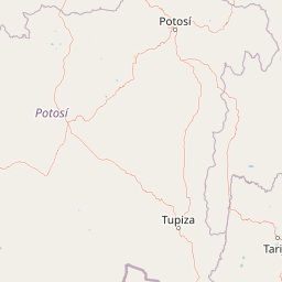
Map view of Área Protegida Municipal Ecoparque Encantado

Use this park location map to pinpoint Área Protegida Municipal Ecoparque Encantado in Bolivia, understand its exact geographic position, and read its mapped placement within the surrounding landscape more clearly.

Pigeon | © OpenStreetMap contributors

Location context for Área Protegida Municipal Ecoparque Encantado

Sud Chichas

Visual reference of inter-Andean dry valleys, canyon walls, and protected habitats

Área protegida municipal Ecoparque Encantado Photos and Landscape Scenery

Photographic collections reveal the rugged topography, steep quebradas, and warm-toned canyon walls defining Área protegida municipal Ecoparque Encantado. Visual documentation helps researchers and visitors analyze the altitudinal gradient, geological formations, and dry-valley ecosystems of the southern Andes.

A ground-level view looking into a narrow desert canyon with towering red sandstone walls under a cloudy sky.

A medium sized, densely branched Prosopis ferox tree growing in a dry, rocky field under a cloudy sky.

Park atlas

Compare adjacent Andean dry valleys and connected conservation landscapes in southern Bolivia.

Parks Near Área protegida municipal Ecoparque Encantado and Surrounding Protected Areas

Continue exploring regional park geography by comparing Área protegida municipal Ecoparque Encantado with other protected landscapes across the southern Bolivian Andes. Evaluating adjacent dry-valley reserves and canyon ecosystems reveals broader ecological patterns throughout the Eastern Cordillera.
Protected areaPotosí
About 60 km away#1 closest

South

Pampa Tholar de las Vicuñas: Protected Andean Puna Landscapes and Geographic Overview

Integrated management area and high-altitude habitat in Potosí, Bolivia.

Pampa Tholar de las Vicuñas covers nearly 60,000 hectares of arid puna in the municipality of Villazón, representing a key intersection of biodiversity and local pastoral traditions. The area features a complex mosaic of piedmont slopes, rolling foothills, and seasonal water networks that provide essential habitat for the Andean condor and large vicuña populations. This protected landscape offers a unique look at high-altitude land management in the transitional zone between the Altiplano and the Eastern Cordillera.

Area
584.8 km²
Established
2018
Relief
Highland
Climate
Arid
A watercolor painting of a simplified, abstract landscape with rolling hills in shades of green, yellow, and muted pink against a white background.
Protected landscapeTarija
About 61 km away#2 closest

East

Parque natural y área de manejo integrado El Cardón: Geography and Protected Area Atlas

High-altitude puna landscapes and cactus diversity in Tarija, Bolivia.

Spanning the high-altitude plateaus of southern Bolivia, this protected area features a unique mosaic of arid terrain, specialized cactus ecosystems, and vital wildlife corridors. The landscape provides a deep look into the puna and pre-puna geography of the Tarija department, including significant archaeological sites and thriving populations of wild vicuñas within a dramatic, high-elevation Andean environment.

Area
300.56 km²
Established
2003
Relief
Mountain
Climate
Arid
Wildlife reserveTarija Department
About 75 km away#3 closest

East

Tajzara Wildlife Reserve: Geographic and Landscape Overview of the Tarija Basin

High-altitude wetlands and saline lagoons in the Bolivian Andes

Tajzara Wildlife Reserve stands as a critical high-altitude wetland complex within the Tarija Department. This protected landscape sustains life across saline lake beds, seasonal pools, and marshy margins, functioning as a vital refuge for migratory waders and flamingo populations in the harsh, arid climate of the Bolivian Altiplano.

Area
13 km²
Established
1999
Relief
Highland
Climate
Alpine
Watercolor illustration showing a pale green rural landscape with rolling hills, scattered trees, a winding path or stream, and small buildings in the distance
Biosphere reserveBolivia
About 88 km away#4 closest

East

Reserva Biológica de la Cordillera de Sama: Protected Mountain Landscapes of Southern Bolivia

High-Andean biosphere reserve featuring lagoons, dunes, and ancient pathways.

Reserva Biológica de la Cordillera de Sama encompasses a vast elevation range from dry inter-Andean valleys to the 4,700-meter peaks of the Cordillera Oriental. This reserve protects the endorheic Tajzara basin, where seasonal lagoons and sand dunes contrast with relict forests and steep mountain ravines. Its geography offers a complex mosaic of ecosystems, providing essential water sources and specialized habitat for endemic fauna within the southern Bolivian highlands.

Area
1,085 km²
Established
1991
Relief
Mountain
Climate
Alpine
National parkArgentina
About 148 km away#5 closest

Southeast

Baritú National Park National Park: Mapped Protected Landscapes in Argentina's Geography

Understand the natural terrain and geographic setting of this Argentinian park.

Baritú National Park represents a distinct national park entity within Argentina, crucial for understanding the country's protected landscapes and regional geography. This page provides specific atlas-level detail on its mapped boundaries and the surrounding natural terrain. Explore Baritú National Park as a key geographic feature contributing to the broader understanding of conservation areas across South America, grounded in factual, map-oriented discovery.

Area
720 km²
Established
1974
IUCN
II
Relief
Mountain
A soft watercolor illustration of a river flowing through a lush landscape with gentle green hills in the distance.
Wildlife reserveTarija
About 157 km away#6 closest

East

Reserva nacional de flora y fauna de Tariquía: Atlas and Geographic Protected Area Overview

Montane cloud forest and subandean river valleys in Tarija

This wildlife reserve preserves the most intact stands of Yungas Tucumano-Boliviano forest in Bolivia. Featuring a dramatic vertical zonation from foothill selva to high-elevation pine woodlands, the area serves as a primary hub for ecological research and conservation in the rugged landscapes of Tarija near the Argentine border.

Area
2,468.7 km²
Established
1989
Relief
Mountain
Climate
Subtropical
A soft watercolor painting depicting a wide, pale landscape with rolling hills, a central body of water with pinkish tones, and muted green vegetation.
Wildlife reservePotosí
About 168 km away#7 closest

Southwest

Reserva nacional de fauna andina Eduardo Abaroa: Protected Area and Andean Terrain Map

High-altitude volcanic landscapes and flamingo wetlands in Potosí, Bolivia.

The Reserva nacional de fauna andina Eduardo Abaroa represents one of the most distinctive protected landscapes in the Andes. Spanning across the Altiplano, the terrain encompasses geothermal geyser fields at Sol de Mañana, dramatic volcanic summits like Licancabur, and specialized mineral lagoons. This protected area offers a look at extreme environmental adaptation, where high-altitude desert formations meet rare, nutrient-rich wetlands that sustain significant populations of Andean, James's, and Chilean flamingos.

Area
7,147.45 km²
Established
1973
IUCN
IV
Visitors
152.9K annual
Protected areaGran Chaco Province
About 223 km away#8 closest

East

Aguaragüe National Park and Integrated Management Natural Area: Bolivia's Easternmost Sub-Andean Protected Landscape

Explore its mapped mountain geography and ecological diversity.

Aguaragüe National Park and Integrated Management Natural Area is a crucial protected area in Bolivia's Gran Chaco Province, defined by the Serranía del Aguaragüe mountain range. This landscape offers a unique opportunity to explore a geographic transition zone where Southern Andean Yungas montane forests converge with Dry Chaco ecosystems. The park's protected boundaries encompass a rugged mountain backbone rising from the lowlands, representing a vital segment of Bolivia's Sub-Andean geography and protected natural areas.

Area
1,083.07 km²
Established
2000
IUCN
II
Relief
Mountain

Common questions about visiting, size, designation, and location context for Área Protegida Municipal Ecoparque Encantado

Área Protegida Municipal Ecoparque Encantado FAQs for park facts, access, geography, and protected area context

Find quick answers about Área Protegida Municipal Ecoparque Encantado, including protected-area facts, park geography, trail and visitor context, and how the park fits into its surrounding country and regional landscape.
MoriAtlas Explorer

Continue Your Protected Areas Search Across the Global Atlas

Deepen your exploration by continuing the structured search for national parks and protected areas worldwide. Utilize the comprehensive filtering capabilities to compare different conservation landscapes and refine your understanding of global park geography. Discover more about the distribution and characteristics of protected natural areas.

Global natural geography