
Mori Atlas logo
Nature reserveAusstichgelände Röntgental

Examining the ecological history and mapped boundaries of this unique railway excavation site

Ausstichgelände Röntgental Nature Reserve: A Protected Wetland Landscape in Brandenburg Germany

Ausstichgelände Röntgental is a distinctive nature reserve in Brandenburg, representing an artificial sand quarry that transformed into a vital wetland habitat. This site offers an insightful look into ecological succession, featuring a clear contrast between open water, reed belts, and alder carr forest divided by the historic Buchenallee. The reserve serves as a key component of the regional Barnim Nature Park conservation network.

wetlandrailway quarryamphibian habitatreed bedalder carrurban fringe nature reserve
A graphic illustration showing a river winding through a valley surrounded by tall cliffs, a waterfall, and evergreen trees.

Ausstichgelände Röntgental

Nature reserve

Park overview

Structured park overview, official facts, and landscape profile for Ausstichgelände Röntgental

Ausstichgelände Röntgental park facts, protected area profile, and essential visitor context

Review the core facts for Ausstichgelände Röntgental, including designation, size, terrain, visitor scale, habitats, and operating context in one park-focused overview.

About Ausstichgelände Röntgental

The Ausstichgelände Röntgental is a compact but ecologically significant nature reserve on the northeastern fringe of Berlin, in the Brandenburg municipality of Panketal. Despite its small size, the reserve holds a distinctive place in the regional conservation network of Brandenburg because its entire physical character is anthropogenic, a fact that has shaped both its ecology and its cultural memory.

The site came into being during the construction of the Berlin–Szczecin railway. Between 1892 and 1895, sand was excavated locally to provide material for embankments along the new suburban rail line, and successive phases of earthworks continued past the turn of the century. The result was a roughly 28-hectare depression, which, once the railway construction ended, was left to natural processes. Over more than a century the pit gradually filled with water and was colonized by reeds, willows, and eventually alder, producing a mosaic of wetland habitats that now form the core of the protected area.

Ecologically, the reserve is dominated by the contrasts already present in its structure. North of the central Buchenallee, shallow open water and reed fringes provide spawning habitat for amphibians, while south of the path the landscape shifts toward humid alder woodland. The reserve is integrated into the joint Berlin-Brandenburg Barnim Nature Park and is bordered, to the west, by Berlin's own Mittelbruch reserve near Berlin-Buch, and, to the north, by the former Hobrechtsfelde sewage farms that have since been reforested.

The site's cultural layer is unusually dense for such a small reserve. The Buchenallee, which bisects the protected area on foot and bicycle, follows the trace of the medieval Uckermärkischer Heerweg, once colloquially known as the Heerweg. In the late twentieth century, the reserve's perimeter also accommodated a railway police weapons workshop, an underground shooting range used by the East German security services, and, from 1979 onward, the Zentrales Aufnahmeheim Röntgental. After the 1989 political change, citizen activism prevented the commercial reuse of these structures, and in May 1990 the weapons workshop and range were handed to conservationists, leading to the establishment of the Naturenschutzstation Niederbarnim. After the Barnim Nature Park was founded in 1998, the station was relocated to Linum, leaving the reserve to revert to a quieter natural setting.

Quick facts and research context for Ausstichgelände Röntgental

The Ausstichgelände Röntgental is a nature reserve (Naturschutzgebiet) in Brandenburg, Germany, falling within the municipality of Panketal near the Berlin suburb of Röntgental. It covers roughly 24.8 hectares, is classified as an IUCN Category IV Habitat and Species Management Area, and lies within the Barnim Nature Park established jointly by Berlin and Brandenburg in 1998.

The reserve originated as a sand quarry created during the building of the Berlin–Szczecin railway embankment in the 1890s, and its present-day ecological character is shaped entirely by that artificial origin. Its primary conservation purpose is the protection of amphibians, with secondary importance for birds and bats. The reserve has been protected since 1990 under a designation that remains in force today.

Protection and recognition

Documented conservation parameters and official administrative designations for the protected site

Ausstichgelände Röntgental Protection Status and Recognized Protected Area Data

Ausstichgelände Röntgental protection status details cover recorded administrative records and formal designation tracking across international databases. Official protected area parameters provide verifiable baseline facts regarding management scope and geographical classification.

Protection details

WDPA ID
162301
Park context

Deeper park guide and search-rich context for Ausstichgelände Röntgental

Ausstichgelände Röntgental history, landscape, wildlife, and travel context

Explore Ausstichgelände Röntgental through its history, landscape character, ecosystems, wildlife, conservation priorities, cultural context, and seasonal travel timing in a structured park guide built for atlas discovery and search intent.

Why Ausstichgelände Röntgental stands out

The reserve is best known for its unusual origin story: a railway borrow pit that was abandoned after the construction of the Berlin S-Bahn embankment and then gradually transformed into a high-value amphibian wetland. The combination of shallow open water, reed beds, and surrounding alder carr creates breeding habitat for common frogs, moor frogs, common toads, crested newts, and smooth newts, supported by populations of grass snake and slow worm. It is also distinctive for its scientific pedigree, having been studied intensively from the late nineteenth century onward by Karl Osterwald of the Berlin Lessing-Gymnasium, who documented hundreds of plant species including rare mosses, fungi, sundews, and cotton grasses. The site remains a textbook example of how a disturbed man-made depression, left to its own devices on the urban fringe, can develop into a biologically rich protected area.
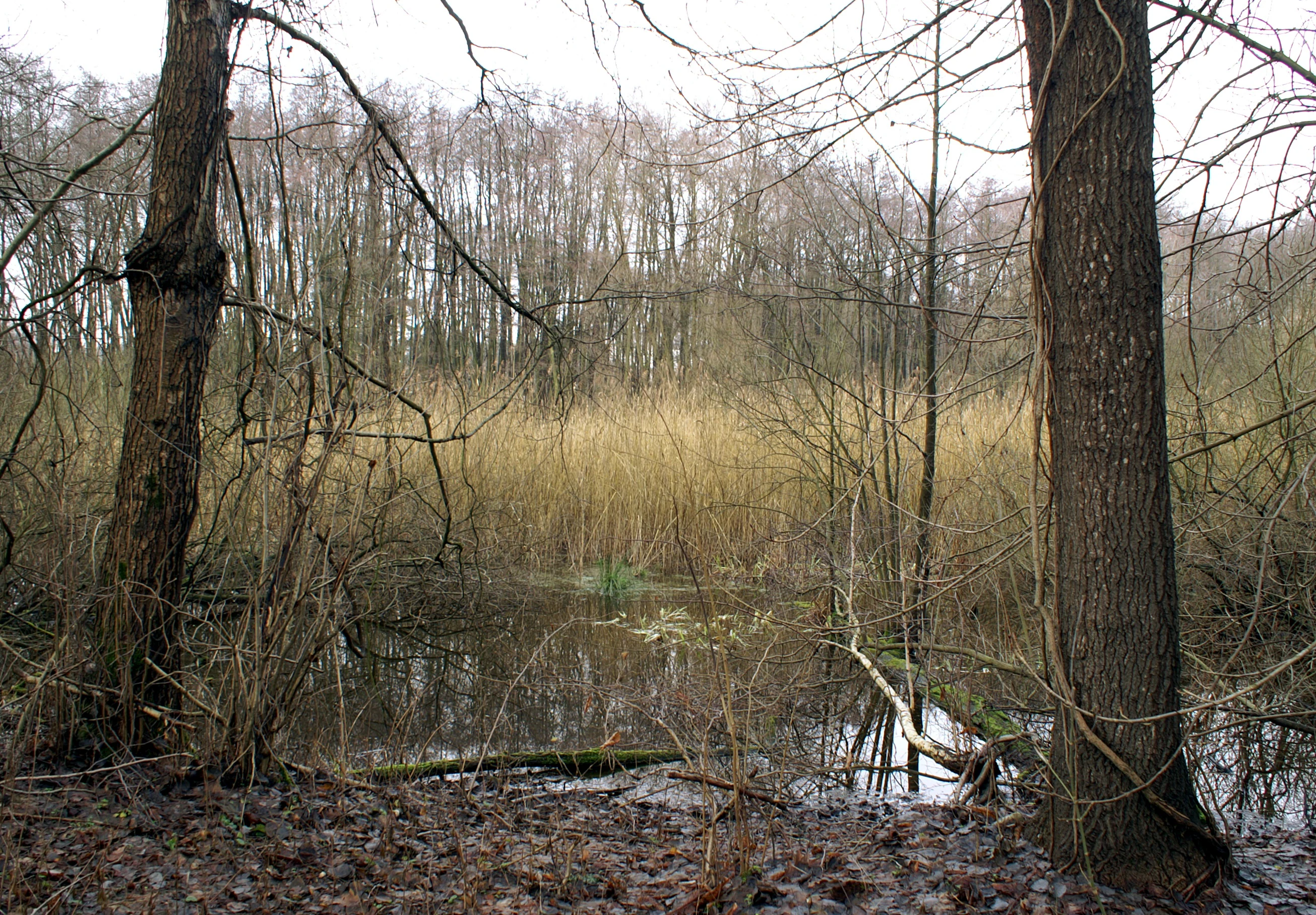
A view of a wetland area at Ausstichgelände Röntgental with a central reed bed surrounded by trees and a foreground pond.
A reed bed and wetland habitat at Ausstichgelände Röntgental.

Ausstichgelände Röntgental history and protected-area timeline

The history of the Ausstichgelände Röntgental begins not with nature but with infrastructure. The Berlin–Szczecin railway, originally built at ground level between 1841 and 1843, was progressively elevated in the 1890s and early 1900s to address growing traffic conflicts, particularly between Berlin and Bernau. Because transporting fill material was expensive, sand was excavated locally, and the borrow pit at Röntgental, opened between 1892 and 1895, supplied embankment material for many years.

Once excavation ceased, the roughly 28-hectare depression became a focus of scientific interest. From the mid-1890s onward, Karl Osterwald, a teacher at the Berlin Lessing-Gymnasium, documented an unusually rich flora on the freshly exposed mineral soils, recording more than 800 plant species over the following decades, including about 190 mosses and 152 fungi, as well as botanical rarities such as variegated horsetail, fir clubmoss, bell heather, butterworts, sundews, and cotton grasses. In 1940 the Prussian Regierungspräsident in Potsdam placed the site under protection to ensure the undisturbed continuation of these observations.

Over the following decades, vegetation succession changed the character of the reserve. As scrub encroached, the originally open and species-rich flora was overtaken, and in 1972 the protective status was lifted. The wetland character, however, persisted, and by the 1970s and 1980s the open water and reed beds had become a strong amphibian habitat, prompting renewed protection in 1986 by the Council of the Bernau district.

A more difficult chapter began in the same period. A railway police weapons workshop and shooting range had been built on the edge of the site, and a police dog training ground was established nearby. In 1979 the Central Intake Home of the GDR (ZAH) was added on the northeastern edge, hidden behind a high corrugated metal fence. The shooting facilities were repurposed by the Stasi, and a sound-insulated range was built into an earthen mound. After the peaceful revolution of 1989, civic groups secured the site's environmental future: the weapons workshop and range were transferred to conservationists in May 1990, and the Naturenschutzstation Niederbarnim was established, briefly managing the reserve.

The decisive protection order came from the Bezirkstag Frankfurt (Oder) on 14 March 1990, under Decision No. 130, the designation that still applies today. The reserve subsequently became part of the joint Barnim Nature Park in 1998, and the local conservation station was relocated, returning Ausstichgelände Röntgental to a quieter, primarily ecological role.

Ausstichgelände Röntgental landscape and geographic character

Despite its modest size, the Ausstichgelände Röntgental contains a surprisingly varied micro-landscape for a site of fully artificial origin. The central organizing feature is the Buchenallee, a beech-lined path that crosses the reserve and divides it into two clearly different ecological halves.

North of the Buchenallee lies the more open terrain: shallow water bodies, reed fringes, and patches of wet willow scrub. This zone is the visual heart of the reserve and the area most strongly shaped by the original sand excavation, since deeper groundwater reaches the surface here.

South of the path the terrain rises slightly and is dominated by alder carr forest, or Erlenbruchwald, a hummocky, waterlogged woodland of black alder that feels distinctly different from the open scenery to the north. Together, these two halves of the reserve produce a compact but legible contrast between open wetland and wet woodland, framed on the broader map by the railway embankment to the south, the Berlin-Buch area to the west, and the reforested Hobrechtsfelde fields to the north.

Ausstichgelände Röntgental ecosystems, habitats, and plant life

Ecologically, Ausstichgelände Röntgental is best understood as an amphibian-centered wetland complex embedded in a wider mosaic of post-agricultural and post-industrial sites. The reserve's habitat structure is unusually diverse for such a small area, comprising open water, extensive reed belts, willow-dominated scrub, and alder carr forest.

This habitat mosaic supports a particularly strong amphibian community, which is the formal reason for the reserve's continued designation. The shallow, fish-free spawning waters are well suited to common frogs, moor frogs, and common toads, while crested newts and smooth newts also use the site. Reptiles such as grass snakes and slow worms are present in the wetter margins.

The reserve is also relevant for bats, which are described as numerous, and for a wide community of breeding and visiting birds, many of which depend on the combination of open water, reed, and adjacent woodland. The botanical heritage, once the reserve's primary scientific attraction, has shifted over time from rare pioneer flora to more typical wetland vegetation, but rare elements from the original succession phase are still part of the site's scientific identity.

Ausstichgelände Röntgental wildlife and species highlights

Amphibians are the headline wildlife group at Ausstichgelände Röntgental, and the reserve's protected status explicitly reflects this. Common frogs and moor frogs are especially abundant, using the shallow, largely fish-free water bodies as spawning habitat, and common toads are also numerous. Both crested newts and smooth newts occur in the reserve's pools, and grass snakes and slow worms inhabit the wetter margins.

The birdlife is similarly noteworthy. Roughly 85 bird species have been recorded in the reserve, of which approximately 50 breed on site. Typical species associated with the woodland mosaic include green woodpecker, black woodpecker, tawny owl, goshawk, hawfinch, golden oriole, and reed bunting, while the growing importance of the northern open water is reflected in increased use by waterbirds.

Bats are also present in significant numbers, although they are mentioned in general terms rather than by species in the source material. Together with the amphibian population, they underline the reserve's continuing role as a small but ecologically dense refuge on the urban edge of Berlin.

Ausstichgelände Röntgental conservation status and protection priorities

Ausstichgelände Röntgental is classified as an IUCN Category IV Habitat and Species Management Area, a designation that frames it as a site where active biodiversity outcomes are pursued through specific protection of habitats and species, in this case primarily amphibians. The conservation goal of the reserve is explicitly the preservation of the wetland conditions that have developed since the 1970s, which make the site a high-quality amphibian habitat.

The reserve is also part of the larger Barnim Nature Park, established jointly by Berlin and Brandenburg in 1998, which connects it functionally with neighboring protected areas such as the Mittelbruch reserve near Berlin-Buch and the renatured former sewage fields at Hobrechtsfelde.

From a conservation-history perspective, the site offers one of the more instructive local case studies in Brandenburg. The early recognition of its scientific value in 1900, the loss of that value under natural succession in the 1970s, and the subsequent redefinition of protection around amphibians show how a single site can be understood and protected differently in different eras. The fact that the current designation from March 1990 has persisted unchanged through reunification, the establishment of the Barnim Nature Park, and a recent administrative reorganization, gives the reserve an unusual degree of legal continuity for an area of just under 25 hectares.

Ausstichgelände Röntgental cultural meaning and human context

Although it is small and ecologically driven, the Ausstichgelände Röntgental carries a layered cultural and historical imprint that goes well beyond its natural history. The Buchenallee that crosses the reserve still follows the route of the medieval Uckermärkischer Heerweg, locally once known as the Heerweg, connecting Berlin with the Uckermark region through Bernau.

The twentieth century added a more contested layer. The site was used, at various points, by East German state security institutions, including a railway police weapons workshop, an underground shooting range, and the perimeter of the Zentrales Aufnahmeheim Röntgental. After 1989, civic groups used the political opening to redirect these buildings toward environmental and social uses, and the Naturenschutzstation Niederbarnim was founded directly on the reserve.

The Vogelwelt reserve thus stands not only for a small wetland on the Berlin city edge but also for a successful local example of post-1989 civil society transforming a previously restricted security site into a publicly accessible conservation area.

Top sights and standout views in Ausstichgelände Röntgental

Ausstichgelände Röntgental stands out as a rare example of a man-made depression that matured into a formally protected nature reserve, offering an unusually legible story of ecological succession in a compact urban-fringe setting. Its central contrast between open wetland north of the Buchenallee and alder carr south of it produces an efficient and diverse habitat mosaic for its size.

The reserve is anchored in the regional conservation network by its inclusion in the Barnim Nature Park and pairs naturally with the nearby Berlin-Buch Mittelbruch reserve. Its long scientific history, from Karl Osterwald's late nineteenth-century plant surveys through the 1940 and 1990 protection orders, gives it a documented continuity that few comparable small reserves in Brandenburg can match.

Best time to visit Ausstichgelände Röntgental

Because the reserve is small and centered on amphibian breeding habitat, the most ecologically interesting season is spring, when frogs, toads, and newts actively use the shallow water bodies for spawning and the reed beds are at their most visible. Early morning visits during this period offer the best chance to hear amphibian choruses and observe breeding activity.

In summer, the reserve is at its most visually lush, with mature reed vegetation, dense alder foliage, and active birdlife, including woodland species along the Buchenallee. Autumn brings muted colors in the alder carr and a quiet atmosphere that suits observational visits. Winter visits are possible but less rewarding for wildlife, as amphibian activity ceases and much of the area is visually subdued.

Monthly climate preview

Long-term representative monthly temperature and precipitation patterns in Brandenburg

Ausstichgelände Röntgental Climate Normals and Annual Temperature Rhythm

Ausstichgelände Röntgental exhibits a measured annual temperature range spanning sub-zero winter minimums to warm summer maximums alongside steady monthly precipitation rates. Detailed multi-year climate normals provide comprehensive monthly meteorological data for deeper analytical study.
Annual mean9 °C
-1 °C20 °C
Jan-1°
Feb
Mar
Apr
May14°
Jun18°
Jul20°
Aug20°
Sep15°
Oct
Nov
Dec
Warmest month
July

20.3 °C

Coolest month
January

-0.9 °C

Wettest month
July

2.4 mm/day

Driest month
April

1.1 mm/day

Park location guide

Geography guide, regional context, and park location map for Ausstichgelände Röntgental

Ausstichgelände Röntgental park geography, regions, and map view in Germany

Understand where Ausstichgelände Röntgental sits in Germany through a broader geographic reading of the surrounding landscape, nearby location context, and its mapped position within the national park landscape.

How Ausstichgelände Röntgental fits into Germany

Germany is a federal republic in Western and Central Europe with a population of over 83 million across sixteen constituent states. It is Europe's largest economy by nominal GDP and a major global exporter and importer. The capital is Berlin, and the country borders Denmark, Poland, Czech Republic, Austria, Switzerland, France, Luxembourg, Belgium, and the Netherlands.

Wider geography shaping Ausstichgelände Röntgental in Germany

Germany is located in Western and Central Europe, spanning 357,022 km². It borders Denmark to the north, Poland and the Czech Republic to the east, Austria and Switzerland to the south, and France, Luxembourg, Belgium, and the Netherlands to the west. The country has coastlines on the Baltic Sea and North Sea to the north, with the Alps located in the southern region.

Map view of Ausstichgelände Röntgental

Use this park location map to pinpoint Ausstichgelände Röntgental in Germany, understand its exact geographic position, and read its mapped placement within the surrounding landscape more clearly.

Pigeon | © OpenStreetMap contributors

Location context for Ausstichgelände Röntgental

Brandenburg

Visualizing the habitats, wetlands, and protected terrain of Brandenburg

Ausstichgelände Röntgental Photos and Landscape Scenery

Photographic documentation reveals the distinctive micro-landscape of Ausstichgelände Röntgental, featuring open wetland zones and dense alder carr forest. Visualizing these protected habitats helps interpret ecological succession and terrain character across the urban fringe.

A view of a wetland area at Ausstichgelände Röntgental with a central reed bed surrounded by trees and a foreground pond.

A wetland area featuring sparse trees rising out of shallow standing water and marshy vegetation during a cloudy day.

Park atlas

Compare regional wetland reserves, natural parks, and protected habitats across Brandenburg

Parks Near Ausstichgelände Röntgental and Surrounding Protected Landscapes

Browsing parks near Ausstichgelände Röntgental reveals adjacent wetland reserves and regional conservation areas across the surrounding landscape. Comparing these protected habitats provides broader geographical context for urban fringe nature reserves and regional ecosystems.
Watercolor illustration showing a soft landscape with a pond, marsh vegetation, and a background of rolling hills or meadows.
Nature reserveBerlin
About 0.9 km away#1 closest

Southwest

Mittelbruch Nature Reserve: Mapped Wetland Geography and Protected Landscape in Berlin

Examining lowland peat diggings and protected moorland ecosystems

Mittelbruch stands as a compact nature reserve in northeastern Berlin, featuring a layered landscape of former peat diggings and open moor meadows. This area plays a critical role in urban conservation by providing essential refuge for waterbirds and diverse meadow flora. Utilize the atlas to study the reserve's internal geography, including its managed reed belts and surrounding forest edges that form a distinct ecological mosaic within the city landscape.

Area
0.282 km²
Established
1997
IUCN
IV
Relief
Lowland
A watercolor illustration of a rural landscape with low hills, trees, and grassy meadow areas.
Nature reserveBrandenburg
About 2.6 km away#2 closest

Northeast

Faule Wiesen bei Bernau Nature Reserve: Mapped Landscapes and Geography of Brandenburg

A vital Panke river corridor protecting rare meadow and woodland biomes.

Spanning 37 hectares near the northern edge of Berlin, Faule Wiesen bei Bernau offers a study in contrasting landscapes. The reserve features open wet meadows and small ponds alongside sandy dry grasslands and oak woodlands. It remains an essential ecological link within the Barnim district, preserving critical habitats for amphibians and orchids within the broader Brandenburg geography.

Area
0.37 km²
Established
2000
Relief
Lowland
Scope
Terrestrial
A horizontal watercolor illustration showing a pinkish-purple foreground of heathland vegetation transitioning into a line of light green trees against a pale, washed-out hilly background.
Nature reserveBrandenburg
About 3 km away#3 closest

North

Schönower Heide Nature Reserve: An Atlas View of Brandenburg Protected Heathlands

A restored landscape of glacial dunes and sandy heath

Schönower Heide stands as a significant nature reserve in Brandenburg, Germany. The area protects a unique combination of open sand heath, pine woodland, and wetland meadows formed on post-glacial outwash plains. This protected landscape is recognized for its successful transition from former military terrain into a vibrant habitat for diverse flora and fauna, including managed populations of red deer and mouflon within its fenced boundaries.

Area
5.334 km²
Established
2000
IUCN
V
Relief
Lowland
A horizontal watercolor painting depicting a marshy landscape with ponds, green vegetation, and soft distant hills against a light background.
Nature reserveBerlin
About 4.6 km away#4 closest

Southwest

Karower Teiche Nature Reserve: Mapped Protected Wetland Geography in Northeast Berlin

Transitional lowland fen and pond mosaic

Karower Teiche protects a unique 128 hectare wetland mosaic in the Pankow district of Berlin. Centered on four shallow ponds and extensive reedbeds, the reserve maintains a vital ecological corridor between the Barnim plateau and the Berlin glacial valley. This site provides essential habitat for amphibians and reed-specialist birds within an urban setting.

Area
1.286 km²
Established
1994
IUCN
IV
Relief
Lowland
A soft watercolor painting featuring green grasses in the foreground, calm water, and a tree line along the horizon.
Nature reserveBrandenburg
About 7.1 km away#5 closest

West

Schönerlinder Teiche Nature Reserve in Brandenburg: Protected Landscape and Geographic Atlas

Explore the wetland mosaic, bird-rich ponds, and grazing conservation areas

Schönerlinder Teiche offers a rare look at post-agricultural land transformation, featuring ponds, meadows, and reed habitats in the Brandenburg region. This nature reserve serves as an essential bird sanctuary and educational site, with water buffalo and Konik horses contributing to ongoing habitat maintenance. View the detailed geography of this protected area and its role within the wider Barnim Nature Park network.

Area
0.408 km²
Established
1997
IUCN
IV
Relief
Lowland
A watercolor painting of a serene fen or wetland with reeds in the foreground, calm water, and rolling hills in the background under a soft pastel sky.
Nature reserveBarnim District
About 7.2 km away#6 closest

Northeast

Ladeburger Schaeferpfuhle: Nature Reserve and Protected Landscape in Barnim District

Mapped lowland fen ecosystems and habitat geography

Located in the Barnim District of Germany, Ladeburger Schaeferpfuhle is a designated nature reserve defined by its post-glacial lowland fen terrain. This area preserves a mosaic of wet meadows, shrub thickets, and pools that support specialized plant and wildlife populations. The site serves as a vital example of regional hydrology, maintaining open landscapes through traditional grazing practices that protect this fragile habitat.

Area
0.267 km²
Established
2000
Relief
Lowland
Climate
Temperate
A watercolor painting of a flat, marshy landscape with soft green trees in the midground and pale hills under a light sky in the background.
Nature reserveBerlin
About 7.4 km away#7 closest

South

Falkenberger Rieselfelder Nature Reserve: A Detailed Atlas of Berlin Protected Lands

Reclaimed wetland geography and urban conservation habitats

Falkenberger Rieselfelder acts as an ecologically rich refuge where former industrial irrigation fields have been repurposed into a mosaic of seasonal pools and meadows. Located on the urban fringe of Berlin, this nature reserve offers a unique look at how conservation grazing and habitat management support species like the great crested newt within a dense metropolitan region.

Area
0.881 km²
Established
1995
IUCN
IV
Relief
Lowland
Watercolor painting of a peaceful wetland landscape with lush green trees, reeds, and soft hills in the background under a light sky.
Nature reserveBerlin
About 7.8 km away#8 closest

South

Malchower Aue Nature Reserve: A Detailed Atlas of Urban Protected Landscapes in Berlin

Wetland habitats and glacial terrain within the Berlin city limits.

Malchower Aue stands as a protected enclave of wetland diversity featuring a system of reed-fringed peat-cutting ponds, wet meadows, and rare dry-grassland vegetation on historical soil mounds. This site provides a vital geographic perspective on how post-glacial relief and human land-use history shape protected areas within the modern urban landscape of Berlin.

Area
0.222 km²
Established
1995
Relief
Lowland
Climate
Temperate

Common questions about visiting, size, designation, and location context for Ausstichgelände Röntgental

Ausstichgelände Röntgental FAQs for park facts, access, geography, and protected area context

Find quick answers about Ausstichgelände Röntgental, including protected-area facts, park geography, trail and visitor context, and how the park fits into its surrounding country and regional landscape.
MoriAtlas Explorer

Continue Your Protected Areas Search Across the Global Atlas

Deepen your exploration by continuing the structured search for national parks and protected areas worldwide. Utilize the comprehensive filtering capabilities to compare different conservation landscapes and refine your understanding of global park geography. Discover more about the distribution and characteristics of protected natural areas.

Global natural geography