
Mori Atlas logo
Protected landscapeBaumberge

Exploring the glacial sand terrain, xerothermic habitats, and protected biodiversity within the Tegeler Forst

Baumberge Protected Landscape: Mapping Berlin's Rare Inland Dune and Dry Grassland Ecosystems

(Naturschutzgebiet Baumberge)

The Baumberge form a distinctive 47 hectare protected landscape on the northern outskirts of Berlin, characterized by rare inland dune formations and subcontinental blue-grass dry grasslands. This site preserves an essential mosaic of open sand and heath vegetation that contrasts sharply with the surrounding dense forest cover of the Tegeler Forst. The geography reflects complex late-glacial Aeolian deposits, offering a unique opportunity to study the intersection of urban environmental conservation and rare post-glacial terrain types.

inland dunesbinnendünendry grasslandssand heathxerothermic habitatNatura 2000
A flat-style vector illustration showing a winding river through a valley flanked by rocky cliffs and pine trees under a pale sky with a sun.

Baumberge

Protected landscape

Park overview

Structured park overview, official facts, and landscape profile for Baumberge

Baumberge park facts, protected area profile, and essential visitor context

Review the core facts for Baumberge, including designation, size, terrain, visitor scale, habitats, and operating context in one park-focused overview.

About Baumberge

The Baumberge are a compact but ecologically rich inland dune reserve on the northwestern edge of Berlin. Covering roughly 47 hectares, they sit within the southern part of the Tegeler Forst landscape protection area in Heiligensee, a district of Reinickendorf. Although small, the site is one of the most important open sand habitats in the Berlin-Brandenburg region because its dune morphology, vegetation patterns, and invertebrate communities have survived largely intact where almost all other inland dunes have been reclaimed by forest.

Geologically, the Baumberge belong to the northern edge of the Berlin glacial valley, where late-glacial winds shaped parabolic dunes and broader sand sheets running roughly west-east or northwest-southeast. The site reaches elevations near 62 meters above sea level on its highest crests and drops to the wet lowlands of the Lingenpfuhl pond at about 32 meters. Beneath the dune sand lies a foundation of glacial valley sands and boulder-bearing till, typical of the surrounding Barnim and Glien plateaus.

Ecologically, the reserve is remarkable for combining four main habitat types in a very small space: open dune sand, sand heath with heather and broom, dry sand grasslands, and a small wet zone around the Lingenpfuhl in the southwest. These habitats support both common Pine and mixed-oak woodland species of the Tegeler Forst and a set of genuinely rare dry-habitat plants and invertebrates. Because much of the dune structure is open rather than forested, visitors encounter an unusual, almost steppe-like atmosphere within an otherwise forested Berlin landscape.

Quick facts and research context for Baumberge

The Baumberge cover about 47 hectares in Berlin-Heiligensee, within the southern part of the Tegeler Forst landscape protection area. They represent one of only two remaining open inland dune complexes in Berlin, the other being the Wilhelmshagen-Woltersdorfer Dünenzug. The site is a designated nature reserve and a Fauna-Flora-Habitat area within the Natura 2000 network.

The dunes reach about 62 meters above sea level at their highest point, while the lowest area, around the Lingenpfuhl pond, lies near 32 meters. The sand thickness varies from a few decimeters to roughly 20 meters, consisting of fine, calcareous-poor Aeolian sands. The area combines open dune, dry sand heath, dry grassland, warm shrub communities, and a small wet zone around the Lingenpfuhl in the southwest.

Protection and recognition

Documented terrestrial protection scope and Natura 2000 listings

Baumberge Protection Status and International Recognition Sources

Terrestrial protection status for Baumberge centers on documented Natura 2000 framework recognition sources. Official conservation records outline the established management scope and international designation details for this protected area.
Park context

Deeper park guide and search-rich context for Baumberge

Baumberge history, landscape, wildlife, and travel context

Explore Baumberge through its history, landscape character, ecosystems, wildlife, conservation priorities, cultural context, and seasonal travel timing in a structured park guide built for atlas discovery and search intent.

Why Baumberge stands out

The Baumberge are best known for being one of the last open inland dune landscapes in the Berlin region, preserving a rare mosaic of sand heath, dry grassland, and open sand communities on nutrient-poor glacial deposits. Among its most distinctive features are the subcontinental Blauschillergrasfluren, dry grasslands dominated by blue-grey Koeleria glauca, which are restricted to very few sites across Europe and are a priority habitat under the EU Habitats Directive. The reserve is also closely associated with a specialised community of warmth-loving invertebrates. These include the sand earwig, the dune tiger beetle, three species of antlion found locally in Berlin, and the nationally threatened Kiesbankgrashüpfer grasshopper. The combination of conserved dune morphology, rare dry grassland flora, and this xerothermic fauna is what makes the Baumberge ecologically distinctive despite its small size.
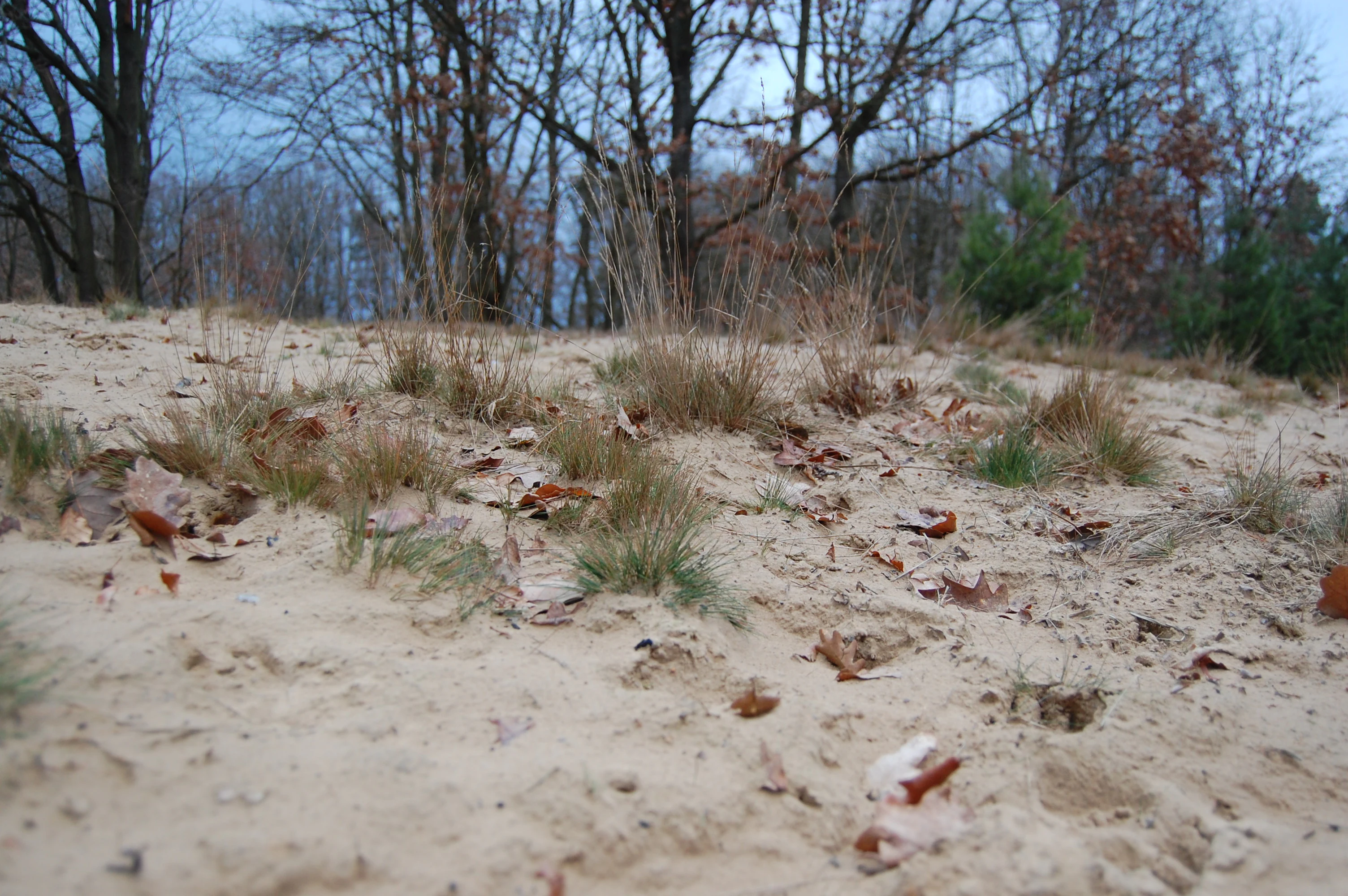
A sandy, sparse dune surface with patches of dry grass and fallen leaves, bordered by a backdrop of bare, winter-season trees.
Inland dune landscape in the Baumberge protected area, Berlin.

Baumberge history and protected-area timeline

The history of the Baumberge is a story of repeated human use that inadvertently preserved their open character. The dunes were originally formed in the late glacial period, but by the early medieval period settlers of the nearby Heiligensee village, founded in the 13th century as Hyelegense, began clearing the surrounding forests for fields, pasture, and beekeeping. Trees were left standing only on the higher dunes, which stood out as wooded hills above cleared heathland and were already labelled Bumberg on the earliest known 1739 map of the Heiligensee field area.

This open state held throughout much of the 19th century. By around 1875 a young forest had grown up on the Baumberge, and by about 1910 they appeared indistinguishable from the surrounding Tegeler Forst on city maps. That changed in 1928 when the site was used as a sand borrow pit for construction of the Kremmener Bahn railway, opening wide forest clearings into the dunes.

During the Second World War and afterwards, the Baumberge were heavily cleared again. From the end of the war until 1994, they served as a French Allied military training ground, and tracked vehicles in particular prevented trees from re-establishing. Illegal motocross and similar uses further kept the sand open. Since 1994, formal nature protection has reduced these disturbances, although the area is still used for local recreation, and conservation management now includes deliberate removal of succession species to mimic the historical open landscape.

Baumberge landscape and geographic character

The Baumberge landscape is shaped almost entirely by sand. The dunes form parabolic and broader sheets aligned west-east or northwest-southeast, the classic pattern of late-glacial Aeolian deposits on the northern edge of the Berlin glacial valley. The highest crests rise to about 62 meters above sea level, while the lowest point, the Lingenpfuhl basin in the southwest, lies near 32 meters.

Sand thickness is highly variable. On most of the area it is only a few decimetres, but on the highest dunes it reaches around 20 meters. The sands are bright, fine, and mostly calcareous-deficient, with humic bands from fossil vegetation and the locally typical Osteokollen, calcified ancient root traces. In the dune valleys finer-grained valley sands appear, with carbonate layers and silty loam, and beneath the whole complex lies the glacial till that floors the wider Berlin countryside.

The visual character of the Baumberge contrasts strongly with the surrounding Tegeler Forst. Where the forest is dense and closed, the Baumberge offer open sandy expanses, low heather, scattered shrubs, exposed crests, and small dune valleys, giving the site an unusually open, almost semi-arid feeling within an otherwise urban and forested setting.

Baumberge ecosystems, habitats, and plant life

The ecological identity of the Baumberge rests on their exceptionally nutrient-poor, calcareous-deficient sand and on the persistent openness of the terrain. Four major habitat types coexist in a compact area: open dune sand colonized by pioneers, inland sand heaths dominated by heather and broom, xerothermic dry sand grasslands, and small zones of wet and moist vegetation around the Lingenpfuhl.

The most distinctive vegetation is the subcontinental Blauschillergrasflur, a dry grassland type dominated by Koeleria glauca that occurs in very few localities across Europe and is treated as a priority habitat under the EU Habitats Directive. Other characteristic communities include silver-grass and red bent grasslands, heaths of Calluna vulgaris and Genista species, and, at the margins, scattered Pine, sessile oak, and pedunculate oak stands typical of the Tegeler Forst.

Succession is a constant pressure on the site. Land-reed grass, aspen, black locust, and Scots Pine all push in from the edges and from planted stands. Conservation management therefore includes periodic removal of woody plants and controlled disturbance to maintain the open dune character on which the rare flora depends.

Baumberge wildlife and species highlights

The Baumberge are especially significant for invertebrates that depend on dry, warm, open sand habitats. The site hosts a rich xerothermic fauna of ground beetles, spiders, grasshoppers, butterflies, and aculeate hymenopterans, many of which are highly specialised and stenotopic.

Among the most notable species are the sand earwig, adapted to life in warm sandy soils, the dune tiger beetle, a characteristic predator of open dune surfaces, and all three antlion species recorded in the Berlin region, including the rare dune antlion, which in Berlin has been documented mainly at this site, the Windmühlenberg in Gatow, and the Fichtewiese on the edge of the Spandauer Forst. The Kiesbankgrashüpfer grasshopper, nationally considered endangered, also occurs here.

Protected vertebrates include the sand lizard in dry open habitats and the garlic toad around the wet zones of the Lingenpfuhl. The general bird and mammal fauna largely mirrors the surrounding Tegeler Forst, since many species use the Baumberge as an open structure embedded within a wider forested habitat.

Baumberge conservation status and protection priorities

Conservation significance is the core reason the Baumberge exist as a protected area today. The site is designated as a European Fauna-Flora-Habitat area and is part of the transboundary Natura 2000 network. It is one of only two inland dune complexes in Berlin where open sand habitat and dry sand grassland vegetation have survived; the other is the Wilhelmshagen-Woltersdorfer Dünenzug. The priority habitat singled out for special protection is the subcontinental Blauschillergrasflur, a dry grassland type that is extremely rare across Europe.

By 1994, heavy recreational and military use had pushed many xerothermic invertebrate populations into strong decline, and several characteristic plant species survived only in small remnants. Open silver-grass grasslands and dwarf-shrub heaths were particularly affected by drifting sand and by nutrient enrichment from atmospheric deposition, which converted some sand dry grasslands into more nitrogen-loving herb communities at the site margins.

Current official management aims at preserving the open dune habitats, sustaining the Blauschillergrasrasen, heaths and thrift communities, and the silver-grass dry grasslands; promoting open pine stands on xerothermic sites with rich dry-grass understorey; and maintaining acidophilous oak forests on sandy plains where they do not threaten open dune areas. Practical measures include periodic removal of succession species such as reed grass, aspen, black locust, and invasive pine, and the controlled continuation of visitor pressure that helps keep the sands open, with sensitive zones physically fenced off.

Baumberge cultural meaning and human context

The cultural context of the Baumberge is closely tied to the founding of Heiligensee in the early 13th century. As Ascanian margraves brought settlers into the region, those settlers cleared the surrounding forests to create agricultural fields, pasture, and heathland for beekeeping. They preserved trees only on the higher dunes, which then stood out from the cleared surroundings as distinctive wooded hills and gave the site its name: the hills with trees, the Baumberge.

This long pattern of clearance, use, and partial abandonment, followed by 20th-century sand extraction, wartime deforestation, postwar use as a French military training ground, illegal motocross, and finally formalized nature protection, has shaped not only the landscape but the local identity of the area. The site remains a popular local recreation destination, used in conjunction with the Schullandheim school camp within the reserve, and modern conservation efforts deliberately integrate some of that continued human presence into dune management rather than excluding it entirely.

Top sights and standout views in Baumberge

Open inland dune landscape in the northwest of Berlin, within the Tegeler Forst landscape protection area. Home to one of Europe's priority subcontinental Blauschillergrasfluren dry grasslands, a habitat of European conservation concern. Hosts a specialised xerothermic invertebrate fauna including the sand earwig, dune tiger beetle, the nationally threatened Kiesbankgrashüpfer grasshopper, and all three Berlin antlion species. Combines open dune, sand heath, dry grassland, and a wet Lingenpfuhl pond basin in a compact site of roughly 47 hectares.

Best time to visit Baumberge

Late spring and summer are the most rewarding seasons for visiting the Baumberge. From May through August, the sand heaths and dry grasslands are in flower, with heather, broom, and characteristic dune species producing visible color across the open sands, and warmth-loving insects are most active. Sunny summer days also best reveal the unusual, semi-open character of the dunes against the dense surrounding forest.

Autumn and winter visits are quieter and emphasize the dune morphology itself, with bare sand, exposed crests, and sheltering pine and oak stands at the margins. The wet zone around the Lingenpfuhl is easiest to observe in spring, when groundwater conditions and growing bird activity make it more visible, while frozen or snowy conditions in winter highlight the very different microclimate of the dunes compared with the forest around them.

Monthly climate preview

Long-term monthly averages and temperature ranges for the Baumberge protected terrain

Baumberge Climate Normals and Measured Annual Temperature and Precipitation Patterns

Historical climate records from a representative coordinate in Baumberge show measured monthly temperature ranges alongside consistent precipitation averages spanning the entire year. Examining the full twelve-month profile provides complete historical climate normals and monthly weather patterns for the protected terrain.
Annual mean9 °C
-1 °C20 °C
Jan-1°
Feb
Mar
Apr
May14°
Jun18°
Jul20°
Aug20°
Sep15°
Oct
Nov
Dec
Warmest month
July

20.3 °C

Coolest month
January

-0.7 °C

Wettest month
July

2.4 mm/day

Driest month
April

1 mm/day

Park location guide

Geography guide, regional context, and park location map for Baumberge

Baumberge park geography, regions, and map view in Germany

Understand where Baumberge sits in Germany through a broader geographic reading of the surrounding landscape, nearby location context, and its mapped position within the national park landscape.

How Baumberge fits into Germany

Germany is a federal republic in Western and Central Europe with a population of over 83 million across sixteen constituent states. It is Europe's largest economy by nominal GDP and a major global exporter and importer. The capital is Berlin, and the country borders Denmark, Poland, Czech Republic, Austria, Switzerland, France, Luxembourg, Belgium, and the Netherlands.

Wider geography shaping Baumberge in Germany

Germany is located in Western and Central Europe, spanning 357,022 km². It borders Denmark to the north, Poland and the Czech Republic to the east, Austria and Switzerland to the south, and France, Luxembourg, Belgium, and the Netherlands to the west. The country has coastlines on the Baltic Sea and North Sea to the north, with the Alps located in the southern region.

Map view of Baumberge

Use this park location map to pinpoint Baumberge in Germany, understand its exact geographic position, and read its mapped placement within the surrounding landscape more clearly.

Pigeon | © OpenStreetMap contributors

Location context for Baumberge

Berlin
Recorded earthquake history

View the Historical Earthquake Records Associated with the Baumberge Landscape

Explore the collection of recorded seismic events located near the Baumberge protected inland dunes. MoriAtlas provides a structured look at magnitude and depth data for events identified within the regional vicinity, offering a clear geographic perspective on past seismic activity.

Baumberge Earthquake History Records

Catalogued events

40 events

Strongest magnitude

Magnitude 4.7

Most recent event

Dec 20, 2008

This history includes earthquakes recorded inside the park or within 50 km of its borders

Explore protected area terrain, rare dry grassland habitats, and sandy topography

Baumberge Photos and Landscape Scenery: Visualizing Berlin Inland Dunes

Visual documentation of Baumberge reveals the unique topography of its surviving inland dune system and open sand habitats. Examining protected area imagery helps researchers and visitors understand the distinct ecological character of these glacial sand formations.

A sandy, sparse dune surface with patches of dry grass and fallen leaves, bordered by a backdrop of bare, winter-season trees.

A sandy, sparsely vegetated area with bare-branched trees under an overcast sky, characteristic of the Baumberge protected landscape.

Park atlas

Compare adjacent conservation areas and mapped habitats across the surrounding territory.

Exploring Parks Near Baumberge and Surrounding Regional Protected Landscapes

Browsing other protected areas near Baumberge reveals related sand heaths, dry grasslands, and glacial landforms across the surrounding countryside. Extending your regional park comparison helps map connected conservation corridors and ecological reserves beyond a single site.
Nature reserveBerlin
7.8 km away#1 closest

South

Fließwiese Ruhleben: A Glacial Nature Reserve and Wetland Mosaic in Berlin

Mapping a unique urban protected area and its peat marsh topography

Fließwiese Ruhleben is a protected nature reserve in western Berlin that preserves a distinct relic of Weichselian glaciation. The site features a narrow, basin-like depression carved by glacial meltwater, supporting a rich diversity of peat-forming marshland and alder swamp forests. This protected area remains a vital node for regional biodiversity, contrasting sharply with the surrounding urban landscape of the Teltow plateau.

Area
0.118 km²
Established
1959
Relief
Lowland
Climate
Temperate
Watercolor painting of bare trees in a misty, marshy landscape with soft pastel colors.
Nature reserveBrandenburg
About 8.1 km away#2 closest

Northeast

Kindelsee-Springluch Nature Reserve: A Detailed Geographic Atlas of Brandenburg Wetlands

Restored post-glacial lake and wetland landscape in East Brandenburg

Located in the state of Brandenburg, Kindelsee-Springluch represents a refined example of a protected wetland mosaic. The reserve encompasses the Kindelsee lake, sediment-filled meltwater channels, and diverse swamp forests. This site provides a critical window into regional post-glacial geography, featuring a well-defined sequence of mire, sedge meadows, and mixed oak woodlands that have undergone extensive ecological restoration.

Area
0.69 km²
Established
2001
IUCN
IV
Protected landscapeBerlin
About 9 km away#3 closest

South

Tiefwerder-Wiesen Protected Landscape: Berlin Riverine Geography and Floodplain Map

Mapping the historic Havel river floodplains and wetland habitats.

Tiefwerder-Wiesen serves as an important ecological corridor in Berlin, safeguarding the last functional pike spawning grounds within the city. This protected landscape contains a dense network of river arms, ditches, and sedge meadows that illustrate the historical and ongoing geomorphological processes of the Havel river valley.

Area
0.667 km²
Established
1960
Relief
Lowland
Climate
Temperate
A soft watercolor painting showing rolling green hills, patches of open land, and trees against a pale sky background.
Nature reserveHavelland
12 km away#4 closest

Southwest

Döberitzer Heide Nature Reserve: Geographic Atlas and Protected Landscape Mapping

Glacial sand flats and heathlands in the Havelland region

Döberitzer Heide occupies a unique position on the southeastern Nauener Platte, providing a study of dry heath, grassland, and wetland habitats. Once a restricted military training ground, the area now functions as a vital protected landscape where European bison and wild horses maintain open terrains. This atlas entry focuses on the regional geography and the structural components of this nature reserve situated near the urban centers of Berlin and Potsdam.

Area
34.15 km²
Established
1997
Relief
Upland
Climate
Temperate
Watercolor illustration of a serene wetland scene with soft green hills and a light pink sky.
Nature reserveBerlin
About 12 km away#5 closest

South

Sandgrube im Jagen 86 Nature Reserve: Mapped Geography and Protected Area Context

A unique habitat mosaic within the Berlin forest region

Sandgrube im Jagen 86 functions as a protected nature reserve in Berlin, characterized by a bowl-shaped terrain of glacial sands. The area provides a critical habitat for specialized wildlife by balancing nutrient-poor grasslands with open water bodies and sun-exposed slopes, illustrating an effective example of managed conservation within an urban forest.

Area
0.135 km²
Established
1992
IUCN
IV
Relief
Lowland
A soft watercolor painting featuring green grasses in the foreground, calm water, and a tree line along the horizon.
Nature reserveBrandenburg
About 13 km away#6 closest

Northeast

Schönerlinder Teiche Nature Reserve in Brandenburg: Protected Landscape and Geographic Atlas

Explore the wetland mosaic, bird-rich ponds, and grazing conservation areas

Schönerlinder Teiche offers a rare look at post-agricultural land transformation, featuring ponds, meadows, and reed habitats in the Brandenburg region. This nature reserve serves as an essential bird sanctuary and educational site, with water buffalo and Konik horses contributing to ongoing habitat maintenance. View the detailed geography of this protected area and its role within the wider Barnim Nature Park network.

Area
0.408 km²
Established
1997
IUCN
IV
Relief
Lowland
Nature reserveBerlin
About 13 km away#7 closest

South

Windmühlenberg Nature Reserve: Glacial Terrain and Steppe Flora in Berlin

Protected sand-dry grasslands on the Nauen Plateau edge

Windmühlenberg preserves a rare ecological landscape in western Berlin. This glacial hill and nature reserve functions as a protected habitat for steppe-relict flora and specialized insects, serving as a critical point of interest for understanding the geomorphology and sand-based grassland environments of the Havel river valley.

Area
0.051 km²
Established
2002
Relief
Upland
Climate
Temperate
A watercolor painting showing a soft green marshy landscape with low hills in the background and a winding stream in the foreground.
Nature reserveBerlin
About 13 km away#8 closest

South

Hundekehlefenn Nature Reserve: Geography and Protected Wetland Landscapes in Berlin

Glacial meltwater channel and moorland in Grunewald

Hundekehlefenn represents one of the last surviving pieces of original Berlin vegetation, preserved as a nature reserve within the city limits. This compact protected area showcases a glacial meltwater channel geography, featuring marshy depressions, mesotrophic bog remnants, and alder swamp forests. It serves as an essential ecological link within the Grunewaldseenkette lake chain, providing a window into the natural terrain history of the region.

Area
0.1 km²
Established
1987
Relief
Lowland
Climate
Temperate

Common questions about visiting, size, designation, and location context for Baumberge

Baumberge FAQs for park facts, access, geography, and protected area context

Find quick answers about Baumberge, including protected-area facts, park geography, trail and visitor context, and how the park fits into its surrounding country and regional landscape.
MoriAtlas Explorer

Continue Your Protected Areas Search Across the Global Atlas

Deepen your exploration by continuing the structured search for national parks and protected areas worldwide. Utilize the comprehensive filtering capabilities to compare different conservation landscapes and refine your understanding of global park geography. Discover more about the distribution and characteristics of protected natural areas.

Global natural geography