
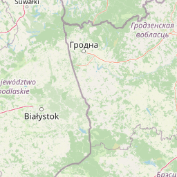
Rivers
Park geography
A comprehensive geographic analysis of terrain, river networks, and protected landscapes
Białowieża National Park Geography and Mapped Territorial Boundaries in Podlaskie Voivodeship
Examine the detailed geographic structure of Białowieża National Park, an expansive protected lowland area within the Podlaskie Voivodeship of Poland. This profile covers the 105.17 square kilometer boundary, temperate forest habitats, and complex hydrology including the Narewka, Łutownia, and Hwoźna river systems.

Europe's last primaeval forest and sanctuary of the European bison
Białowieża National Park
Białowieża National Park is Poland's most significant natural treasure and one of Europe's premier conservation sites. Located in the Podlaskie Voivodeship of eastern Poland, approximately 62 kilometers southeast of Białystok, the park protects the finest remaining fragment of the Białowieża Forest—a sprawling primaeval woodland that once blanketed the European Plain. This ancient forest represents the last intact temperate primeval forest on the continent, with sections having existed without significant human intervention for nearly 800 years. The park sits directly adjacent to the Belarus border, where the continuation of this forest is protected as Belovezhskaya Pushcha National Park, creating one of Europe's few transboundary World Heritage Sites. The park's 105.2 square kilometers encompass a remarkable diversity of habitats, from mixed deciduous forests dominated by oak and hornbeam to spruce-covered wetlands and river valley corridors. What truly distinguishes Białowieża is its ecological authenticity—the forest operates largely according to natural processes rather than management interventions, with dead wood rotting in place, natural forest regeneration, and predator-prey dynamics functioning as they have for millennia. This makes the park invaluable for scientific study and represents a living laboratory that has shaped ecological understanding across Europe. Białowieża holds particular renown as the primary stronghold of the European bison (żubr), the continent's heaviest land animal. Once driven to the brink of extinction in the early 20th century, the species has been brought back from the edge of oblivion through intensive conservation efforts centered on this forest. The park today maintains the world's largest free-ranging population of European bison, with approximately 510 individuals in the Polish portion of the forest.
- Location
- Poland
- Park type
- National park
- Established
- 1932
- Area
- 105.2 km²
Location overview
Podlaskie Voivodeship, Poland, and Transboundary Status
Białowieża National Park Geography and Location Context
Białowieża National Park occupies recorded territory within Poland and Podlaskie Voivodeship. Administrative records confirm its transboundary status across the designated regional network.
- Countries
- Poland
- Regions
- Podlaskie Voivodeship
- Primary location
- Podlaskie Voivodeship
- Geographic setting
- Transboundary · Inland
Boundary and coordinates
Mapped spatial outline and calculated area dimensions
Białowieża National Park Boundary Map and Geographic Extent
Interactive boundary geometry provides clear spatial context for the protected territory. Accompanying measurements detail the recorded surface area and geographic span dimensions.
- Boundary area
- 105.2 km²
- Boundary perimeter
- 66.8 km
- Northernmost point
- 52.8189° N
- Southernmost point
- 52.6989° N
- Easternmost point
- 23.9396° E
- Westernmost point
- 23.7177° E
- Geographic centre
- 52.7644° N, 23.8659° E
- North–south span
- 13.4 km
- East–west span
- 15 km
Terrain and natural features
Explore lowland terrain classifications and recorded natural features
Białowieża National Park Terrain and Named Natural Features
Stored relief data classifies the landscape type as lowland terrain alongside recorded natural features within the protected boundary. Linked feature cards supply names, types, measurements, and spatial relationships where documented.
Selected named natural features
Rivers
Orłówka
Streams
Jaszczurka
Viewpoints
platforma widokowa
Streams
Sirota
Rivers
Narewka
Environmental setting
Temperate broadleaf forest, lowland relief, and boreal climate classifications
Białowieża National Park Environmental Classifications and Physical Setting
Recorded landscape features and habitat types serve as complementary ways to interpret the physical setting across lowland terrain. Stored categories connect directly to relevant protected area destinations within the atlas.
- Relief
- Lowland
- Climate
- Boreal
- Water
- Minor water
- Forest cover
- Mostly forested
- Seasonality
- Year-round
Landscape features
Forest · Woodland · Wetland · Rivers
Habitat types
Temperate broadleaf forest · Boreal forest · Riverine habitat · Wetland
Park atlas
Compare nearby national parks and connected protected landscapes across eastern Europe.
Other Parks Like Białowieża National Park and Protected Areas in the Surrounding Region
Visitors exploring Białowieża National Park can examine other protected areas and regional reserves sharing similar primeval woodland traits. Comparing adjacent conservation landscapes reveals broader ecological patterns across the East European Plain.
National parkBelarus
Park boundaries overlap#1 closest
South

Belavezhskaya Pushcha National Park: Ancient Primeval Forest & European Bison Sanctuary
Explore mapped protected areas and regional geography.
Belavezhskaya Pushcha National Park stands as a testament to Europe's ancient woodland heritage, a protected landscape of immense ecological value. This primeval forest, a sanctuary for the European bison, offers a unique glimpse into an ecosystem preserved for millennia. The park's mapped boundaries and geographic context provide essential detail for understanding its role as a critical natural monument and a cornerstone of regional protected areas.
- Area
- 1,500.69 km²
- Established
- 1932
- IUCN
- II
- Visitors
- 300K annual
National parkPodlaskie Voivodeship
Park boundaries overlap#2 closest
Northwest

Białowieski Park Narodowy: Primeval Forest Geography and Protected Area Overview
Northeastern Poland lowland forest and bison habitat
Białowieski Park Narodowy stands as a landmark of European conservation, protecting a vast stretch of old-growth lowland forest that escaped historical clearing. This map-oriented overview details the forest's layered structure, its network of streams, and its significance as a sanctuary for the European bison within the Podlaskie Voivodeship.
- Area
- 105.17 km²
- Established
- 1932
Protected areaPoland
Park boundaries overlap#3 closest
South
Puszcza Białowieska Protected Area: Primeval Forest Geography and Mapped Boundaries
Ancient lowland forest landscapes of the Polish-Belarusian border
Examine the geographic composition of Puszcza Białowieska, an extensive primeval lowland forest characterized by multi-aged tree stands and abundant deadwood ecosystems. The area serves as a primary site for ecological research into natural forest regeneration and megafauna protection, specifically for the European bison and diverse predator populations living within its protected landscape boundaries.
- Area
- 1,500 km²
- Established
- 1932
- Relief
- Lowland
- Climate
- Temperate
Nature reservePodlaskie Voivodeship
About 13 km away#4 closest
Northwest
Dolina Waliczówki Nature Reserve: Protected Forest and Stream Valley Geography
Key protected area within the Białowieża Forest of Poland
Spanning over 44 hectares, Dolina Waliczówki Nature Reserve serves as a concentrated site for the preservation of natural forest communities and springhead flora in the Podlaskie Voivodeship. The protected terrain, defined by the small Waliczówka stream, illustrates the ecological detail of the broader Białowieża Forest lowland woodland.
- Area
- 0.448 km²
- Established
- 1995
- Relief
- Lowland
- Scope
- Terrestrial
Nature reservePodlaskie Voivodeship
About 25 km away#5 closest
North
Rezerwat przyrody Jezioro Wiejki: Wetland Geography and Protected Landscape in Eastern Poland
Glacial lake basin and peatland ecology in Podlaskie Voivodeship
This nature reserve protects a rare mesotrophic lake and peatland complex, serving as a testament to the glacial history of the Białystok Highlands. The site is noted for its concentric wetland vegetation bands, including floating bog communities and populations of endangered low birch, which offer a clear window into the ecological dynamics of northeastern Polish water systems.
- Area
- 0.225 km²
- Established
- 2005
- Relief
- Lowland
- Climate
- Temperate
Nature reservePodlaskie Voivodeship
About 49 km away#6 closest
Northwest
Bahno w Borkach Nature Reserve: Mapping the Boreal Peatland Landscapes of Podlaskie
A study of protected mire habitats and forest mosaics
Bahno w Borkach Nature Reserve protects a vital boreal-influenced peatland habitat within the larger Knyszyn Forest complex. The mapped landscape includes a complex mosaic of low-mire communities and forest patches that serve as an important reference site for ecological studies of the eastern Polish lowlands.
- Area
- 2.899 km²
- Established
- 1990
- Relief
- Lowland
- Climate
- Boreal
Nature reservePodlaskie Voivodeship
About 56 km away#7 closest
Northwest
Rezerwat przyrody Międzyrzecze: Exploring Protected Woodland Geography in Poland
A detailed geographic look at forest protection in the Knyszyn Forest landscape.
Deepen your understanding of Rezerwat przyrody Międzyrzecze through a focused study of its protected terrain. This site covers the essential geography of the nature reserve, detailing how glacial landforms and internal springs create unique woodland conditions within the Podlaskie Voivodeship. Access mapped data to see how this protected fragment integrates into the broader Knyszyn Forest ecological network.
- Area
- 2.508 km²
- Established
- 1990
- Relief
- Upland
- Scope
- Terrestrial
National parkPodlaskie Voivodeship
58 km away#8 closest
West
Narew National Park: Discover Poland's Premier Wetland National Park with Unique River Geography
Explore its mapped boundaries and rich protected landscape.
Narew National Park represents a significant protected area within the Podlaskie Voivodeship, distinguished by its one-of-a-kind anastomosing river system where the Narew River splits into numerous interconnected channels. This dynamic wetland environment provides critical habitat and showcases a complex interplay of water, land, and diverse ecosystems. Users can explore the park's geographic features, understand its protected landscape status, and appreciate its vital role within the regional atlas through detailed mapping and factual context.
- Area
- 73.5 km²
- Established
- 1996
- IUCN
- II
- Relief
- Lowland
MoriAtlas Explorer
Continue Exploring the Protected Landscapes of Białowieża National Park
Delve into the mapped terrain and ecological structure of Białowieża National Park to understand its role in European wilderness conservation. MoriAtlas provides a comprehensive view of this ancient woodland, including its river systems and habitat zones, to assist in the analysis of its unique primeval geography.
Browse next
Global natural geography
Explore related park routes
Explore MoriAtlas Global ParksBrowse All MoriAtlas ParksGlobal Park Map DiscoveryMoriAtlas: Browse All CountriesBrowse All MoriAtlas ContinentsNational Park Environment AtlasGrand Canyon National Park AtlasYellowstone National Park AtlasYosemite National Park Atlas and GeographySerengeti National Park AtlasGalápagos National Park Protected LandscapeBanff National Park Geography and AtlasKruger National Park Atlas EntryUluṟu-Kata Tjuṯa National Park AtlasExplore Uluru-Kata Tjuta National Park GeographyPlitvice Lakes National Park AtlasFiordland National Park Protected LandscapeGreat Smoky Mountains National Park AtlasAfghanistan National Parks and Protected AreasAlbania National Parks and Protected AreasAlgeria National Parks and Protected AreasAmerican Samoa National Parks and Protected AreasAndorra National Parks and Protected AreasAngola National Parks and Protected AreasAntarctica National Parks and Protected AreasAntigua and Barbuda Park List