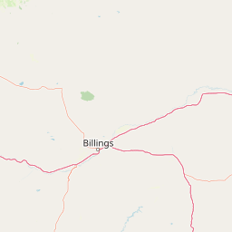
Why Bighorn Canyon National Recreation Area stands out
The recreation area is best known for the long, narrow Bighorn Lake reservoir behind Yellowtail Dam, an arid canyon landscape at the edge of the Pryor Mountains, and the presence of wild Pryor Mountain horses within its boundaries. It is also recognized for the cultural significance of Bighorn Canyon to the Crow Nation, including the Bad Pass Trail along the canyon's west side.
Bighorn Canyon National Recreation Area history and protected-area timeline
The human history of the Bighorn Canyon area reaches back many millennia, with archaeologists identifying evidence of human presence in the vicinity dating as far back as around 12,000 years. The Bad Pass Trail, which runs along the west side of the canyon, connected the Bighorn basin with the Grapevine Creek area and was used by Indigenous peoples for seasonal passage toward buffalo-rich plains rather than as a place of settlement.
The Crow people, also known as Apsaalooke or Absaroka, moved into the Bighorn region during the 16th century and by the 18th century were settled in the Bighorn country, with ongoing territorial conflicts with neighboring tribes. In the late 1800s the Crow aligned with the U.S. Government, and treaties progressively reduced their lands, from the 38 million acres identified in the Fort Laramie Treaty of 1851 to roughly eight million acres in 1868. Through continued 19th-century cessions, Bighorn Canyon nonetheless remained part of the heart of Crow country.
In the mid-20th century, under the Pick-Sloan Flood Control Act of 1944, the federal government decided to dam the Bighorn River. Many Crow opposed the project because the canyon is a sacred place. After negotiation, the government acquired about 12,000 acres of Crow land for $5 million, and the Bureau of Reclamation named the 525-foot dam after Robert Yellowtail, a Crow leader who had actually opposed the dam's construction. The impoundment created Bighorn Lake, and on October 15, 1966, Congress established the national recreation area to manage the resulting landscape. The Bad Pass Trail was added to the National Register of Historic Places in 1975.
Bighorn Canyon National Recreation Area landscape and geographic character
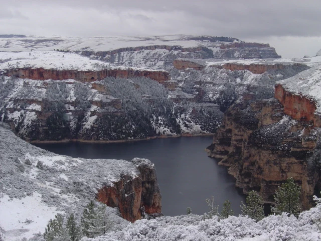
Bighorn Canyon's landscape is shaped by an arid, eroded canyon cut by the Bighorn River and now largely filled by the deep, sinuous Bighorn Lake reservoir. The canyon walls rise sharply from the water in many places, creating a long, narrow ribbon of reservoir that winds through southern Montana and northern Wyoming. The South District around Lovell, Wyoming, is a high-desert environment with sparse rainfall and open, exposed terrain, while the North District near Fort Smith, Montana, transitions into semi-arid country with more vegetation.
Above the canyon, the Pryor Mountains form a prominent backdrop along the Wyoming-Montana border, giving the recreation area elevation, alpine foothills, and access to the Pryor Mountains Wild Horse Range. The contrast between water, sheer canyon walls, dry plains, and forested mountain slopes defines the visual identity of the park and creates very different visitor experiences between the two districts. Below Yellowtail Dam, the smaller Afterbay Lake and the Bighorn River itself continue the river system into a tailwater canyon environment that is well known for trout fishing.
Bighorn Canyon National Recreation Area ecosystems, habitats, and plant life
The recreation area spans multiple ecological zones, from high-desert shrublands in the south to semi-arid grasslands and montane environments in the north. Riparian habitat along Bighorn Lake and the Bighorn River supports waterfowl and aquatic species, while the dry uplands and canyon slopes host drought-adapted wildlife. Variations in elevation, exposure, and moisture across the two districts produce a striking ecological patchwork within a relatively compact area.
Wetland and reservoir habitats, especially around Afterbay Lake, are important for ducks, geese, and other waterbirds, while the surrounding prairie uplands support grassland species and the Pryor Mountains contribute montane habitat. The juxtaposition of desert, riparian, reservoir, and mountain environments gives Bighorn Canyon an unusually compressed ecological range for a single recreation area in the northern Rockies region.
Bighorn Canyon National Recreation Area wildlife and species highlights
Bighorn Canyon is recognized habitat for at least 231 species of birds, making it a notable birding destination in the region. The recreation area is home to bighorn sheep, black bear, mule deer, mountain lions, pronghorn, coyotes, beavers, and marmots, each associated with different habitat zones across the two districts. Below Yellowtail Dam, the cold tailwater fishery supports rainbow and brown trout, while Bighorn Lake itself is managed as a walleye fishery with smallmouth bass, channel catfish, crappie, and other warm-water species.
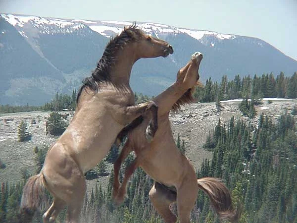
In the North District, the black-tailed prairie dog and the swift fox are both Species of Concern under the Montana Department of Fish, Wildlife & Parks. Northwestern wolves have been observed in the Wyoming region where the South District lies, indicating large-carnivore presence in the broader ecosystem. The overlap between recreation area land and the Pryor Mountains Wild Horse Range also makes Bighorn Canyon one of the places where free-roaming wild horses are a regular part of the landscape.
Bighorn Canyon National Recreation Area conservation status and protection priorities
Bighorn Canyon National Recreation Area preserves a significant stretch of canyon country, reservoir shoreline, and surrounding uplands along the Bighorn River that would otherwise be heavily impacted by water infrastructure development and expanding land use. Its protection maintains wildlife corridors and habitat connectivity between the Bighorn Basin and the Pryor Mountains, including a portion of the Pryor Mountains Wild Horse Range that overlaps with the recreation area.
The recreation area also plays a cultural-conservation role by protecting archaeological sites such as the Bad Pass Trail, which is listed on the National Register of Historic Places, and by managing ranching-era sites such as the L Slash Heart Ranch and Ewing-Snell Ranch. Its conservation significance is enhanced by aquatic invasive species prevention through inspection stations at the marinas, helping protect Bighorn Lake and downstream waters from mussels and other threats.
Bighorn Canyon National Recreation Area cultural meaning and human context
The cultural landscape of Bighorn Canyon is deeply tied to the Crow Nation, whose presence in the Bighorn region goes back centuries and whose identity is now woven into the park itself, including the naming of Yellowtail Dam after Robert Yellowtail. Treaties, land cessions, and the building of the dam are central stories of the area, and the canyon remains a sacred place for the Crow people even though much of its land is now federally owned.
The Bad Pass Trail reflects a much older pattern of Indigenous movement and seasonal use of the canyon, while the four historic ranches inside the park, including the L Slash Heart Ranch, Mason-Lovell Ranch, Cedarvale Ranch, and Ewing-Snell Ranch, document nineteenth- and early twentieth-century ranching in the Bighorn Basin. Caroline Lockhart, who owned the L Slash Heart Ranch, was a notable journalist and novelist of the early 1900s whose books were adapted into silent films in the 1920s, and Cedarvale Ranch was once visited by President Theodore Roosevelt.
Top sights and standout views in Bighorn Canyon National Recreation Area
Bighorn Lake, more than 70 miles long with about 55 miles within the recreation area, is the centerpiece of the park and supports boating, fishing, and water-based recreation. Yellowtail Dam, named after the Crow leader Robert Yellowtail, anchors the North District and the recreation area's modern origin story. The Pryor Mountains wild horses are a signature wildlife feature, with nearly a quarter of their range inside park boundaries.
Other standout qualities include the Bad Pass Trail, a National Register of Historic Places site used for millennia; the acoustically famous triple echo at Sullivan Knob's Trail; a diverse avifauna of more than 200 bird species; and the cultural depth of Crow history in Bighorn Canyon, all set against a striking backdrop of arid canyon walls, reservoir blue water, and forested mountain slopes.
Best time to visit Bighorn Canyon National Recreation Area
Because the South District is high desert and the North District is semi-arid, summers are hot and dry, especially in Wyoming, and are the main season for boating, kayaking, and lake-based recreation. Spring and fall bring more moderate temperatures, fewer crowds, and active wildlife viewing, including waterfowl around Afterbay Lake and seasonal shifts in bird populations along the reservoir. Winters are generally cold and quiet, with snowfall on the canyon rims and limited access to some facilities in the North District.