Mori Atlas logo
Protected areaBosque del Pueblo

A vital mountain forest reserve in Adjuntas preserving headwaters and ecological connectivity.

Bosque del Pueblo: Mapping the Geography and Protected Landscapes of the Cordillera Central

Bosque del Pueblo sits within the mountainous Cordillera Central of Puerto Rico, acting as an essential ecological corridor that links regional state forests. This 738 acre reserve in Adjuntas protects critical headwaters for regional rivers and provides a protected habitat for endangered endemic raptors and migratory birds. The terrain is defined by steep forested slopes and narrow ridges, showcasing a preserved landscape that remains a cornerstone of grassroots conservation efforts.

mountain forestcommunity conservationwatershed protectionendemic raptorsmigratory birdsImportant Bird Area

Bosque del Pueblo

Protected area

Park overview

Structured park overview, official facts, and landscape profile for Bosque del Pueblo

Bosque del Pueblo park facts, protected area profile, and essential visitor context

Review the core facts for Bosque del Pueblo, including designation, size, terrain, visitor scale, habitats, and operating context in one park-focused overview.

About Bosque del Pueblo

Bosque del Pueblo is a mid-sized mountain forest reserve in the heart of Puerto Rico, where rugged slopes, dense tree cover, and highland climate define both its scenery and its ecological value. As one of the island's 20 public forest units, it sits within the broader framework of Puerto Rico's state forest system while retaining a distinctive local character shaped by decades of community advocacy.

The reserve covers approximately 738 acres in the municipality of Adjuntas, spanning the barrios of Vegas Arriba, Vegas Abajo, and Pellejas. Its terrain lies within the Cordillera Central, the principal mountain spine of Puerto Rico, and reflects the steep topography, forest cover, and watershed functions typical of this central highland region. Beyond the forest itself, the surrounding landscape includes small communities and agricultural lands that have coexisted for generations with the forested slopes.

A defining feature of Bosque del Pueblo is its role as a protected headwater area. The forest safeguards upper catchment zones for the Pellejas and Viví rivers and provides tributary source areas for the larger Arecibo River system, making the reserve important not only for biodiversity but also for the hydrological stability of downstream communities. This watershed role reinforces the forest's relevance within a regional network that includes the adjacent Guilarte, Río Abajo, and Toro Negro state forests, which together form one of the most extensive forested corridors in the interior of Puerto Rico.

Equally important is the cooperative management model behind the reserve, in which the Puerto Rico Department of Natural and Environmental Resources works alongside Casa Pueblo and a Community Management Agreement Group. This arrangement reflects the unusual origin of the forest as a community-saved landscape, and it shapes both day-to-day stewardship and the reserve's outreach role through interpretive trails, a plant nursery, recreational areas, and cultural installations celebrating indigenous Taíno heritage.

Quick facts and research context for Bosque del Pueblo

Bosque del Pueblo is a 738-acre state forest unit in the municipality of Adjuntas, in the mountainous interior of Puerto Rico. It is managed jointly by the Puerto Rico Department of Natural and Environmental Resources, a Community Management Agreement Group, and Casa Pueblo, the community-based organization that led the campaign against quarrying.

Its location in the Cordillera Central places it at the headwaters of the Pellejas and Viví rivers and contributes tributary sources to the Arecibo River system. The forest is recognized as part of the Cordillera Central Important Bird Area and has been formally included in Puerto Rico's public forest system, alongside neighboring reserves such as Guilarte, Río Abajo, and Toro Negro.

Protection and recognition

Explore terrestrial protection scope and documented conservation records for Bosque del Pueblo.

Bosque del Pueblo Protection Status and Official Designation Records

Documented protection records outline the terrestrial scope and official conservation framework governing Bosque del Pueblo. Verified management data provides structured insight into designated status and international recognition sources.

Protection details

Protection scope
Terrestrial
Transboundary protection
No
Park context

Deeper park guide and search-rich context for Bosque del Pueblo

Bosque del Pueblo history, landscape, wildlife, and travel context

Explore Bosque del Pueblo through its history, landscape character, ecosystems, wildlife, conservation priorities, cultural context, and seasonal travel timing in a structured park guide built for atlas discovery and search intent.

Why Bosque del Pueblo stands out

Bosque del Pueblo is best known as a community-driven forest reserve that was preserved from open-pit mining thanks to years of local activism by Casa Pueblo. Its defining identity combines watershed protection, ecological connectivity, and rare bird habitat in a single mountainous setting. The forest is particularly recognized for supporting breeding populations of migratory species such as the black-whiskered vireo, as well as two endangered Puerto Rican endemic raptor subspecies: the Puerto Rican broad-winged hawk and the Puerto Rican sharp-shinned hawk. Its role as a forested corridor linking three other major state forest units further amplifies its regional conservation importance.

Bosque del Pueblo history and protected-area timeline

The lands that became Bosque del Pueblo sit over geological deposits of gold, silver, and copper, and between 1980 and 1995 they were targeted for development as an open-air mine and quarry complex. The proposed mining project threatened to convert a large portion of the forested highlands of Adjuntas into industrial extraction territory, with significant implications for forest cover, river systems, and local communities.

Opposition to the quarrying plans was led by Taller de Arte y Cultura-Casa Pueblo, a cultural and environmentalist community group based in Adjuntas. Through more than fifteen years of organizing, public education, and advocacy, the group mobilized civil society against the mining project and placed the ecological and cultural value of the forest firmly on the public agenda. In 1995, the Puerto Rico government agreed to halt mining development in the forest lands, securing the area's long-term protection.

Following this decision, the forest was formally established as a public forest unit and placed under a shared management framework. The Puerto Rico Department of Natural and Environmental Resources provides institutional oversight, while Casa Pueblo, now operating as a non-profit environmental watchdog and community organization, and a Community Management Agreement Group continue to manage the reserve's educational programs, visitor offerings, and on-the-ground stewardship. The history of Bosque del Pueblo is therefore closely tied to grassroots activism, demonstrating how sustained local engagement can permanently redirect land use in mountainous Puerto Rico.

Bosque del Pueblo landscape and geographic character

Bosque del Pueblo occupies mid- to high-elevation terrain in Puerto Rico's Cordillera Central, the island's principal mountain range. The landscape is characterized by steep forested slopes, narrow ridges, and intervening valleys typical of the central highlands, with elevations that support a cooler, more humid microclimate relative to Puerto Rico's coastal areas.

The forest's topography channels rainfall into small streams and headwater tributaries, reinforcing both the rugged relief and the hydrological importance of the terrain. Views from the reserve and surrounding areas often combine dense green forest cover with deeper mountain backdrops, with neighboring state forests such as Guilarte and Toro Negro extending the forested horizon in multiple directions.

Because the reserve was established explicitly to prevent quarrying, much of the original forested topography has been preserved without large-scale surface disruption. This has kept the natural drainage patterns, slope soils, and forest microhabitats largely intact, which in turn shapes the quality of the rivers that originate within the reserve.

Bosque del Pueblo ecosystems, habitats, and plant life

The reserve protects a representative example of Cordillera Central forest, a montane ecosystem that combines broadleaf tree species, understory vegetation, and areas of secondary and recovering growth shaped by the region's land-use history. The forest's interior climate and elevation create conditions favorable for birds, plants, and small forest-dwelling fauna, while the surrounding terrain connects this habitat to a wider matrix of forested lands.

Vegetation patterns within the reserve reflect the interaction of natural montane forest communities with the forest's recovered status after the period of mining threat. The presence of an on-site plant nursery operated by Casa Pueblo further supports native species propagation, restoration efforts, and educational outreach about the local flora.

At a broader scale, the forest's ecology is defined less by any single closed habitat than by its position within a network of protected forest units. Its connectivity to Guilarte, Río Abajo, and Toro Negro, and more locally to Bosque La Olimpia, allows species to move between forest patches across the central highlands, supporting ecological resilience in the interior of Puerto Rico.

Bosque del Pueblo wildlife and species highlights

Bosque del Pueblo is notable particularly for its birdlife, which has been formally recognized at an international scale. The forest has been identified as an important breeding site for the black-whiskered vireo (Vireo altiloquus), a migratory species locally known as the Julián chiví in Puerto Rico. The reserve's montane forest structure and elevation provide nesting habitat that supports this species during its breeding cycle.

The forest also hosts endangered raptor populations tied to Puerto Rico's endemic avifauna. These include the Puerto Rican broad-winged hawk (Buteo platypterus brunnescens) and the Puerto Rican sharp-shinned hawk (Accipiter striatus venator), both of which are recognized subspecies of broader continental species and are restricted in range to Puerto Rico. Their continued presence in Bosque del Pueblo reflects the value of the reserve's mature forest cover and connects the site to broader conservation efforts for Caribbean island raptors.

Together with nearby Bosque La Olimpia and other state forests and protected natural areas in the region, Bosque del Pueblo forms a recognized segment of the Cordillera Central Important Bird Area, established in 2007. This designation underscores the cumulative importance of small and mid-sized forest reserves across the central highlands for sustaining migratory and endemic bird populations in Puerto Rico.

Bosque del Pueblo conservation status and protection priorities

Bosque del Pueblo represents a notable conservation success born from sustained community opposition to extractive industry. The protection of approximately 738 acres of forested mountain land in Adjuntas preserved not only habitat but also a critical part of the Cordillera Central forest network, at a time when large-scale quarrying would have fundamentally altered the landscape.

From a watershed perspective, the reserve secures headwater zones for the Pellejas and Viví rivers and contributes tributary sources to the Arecibo River system. Maintaining forest cover in these upper catchments is essential for regulating water flow, reducing erosion, and preserving water quality for downstream agricultural, residential, and ecological uses, giving the reserve significance well beyond its immediate boundaries.

Institutionally, the forest benefits from a hybrid management structure that combines government oversight by the Puerto Rico Department of Natural and Environmental Resources with on-the-ground stewardship by Casa Pueblo and a Community Management Agreement Group. Its inclusion in the Cordillera Central Important Bird Area since 2007 reinforces its formal recognition as part of an internationally identified priority area for avian conservation, bridging community-led protection and broader hemispheric bird conservation frameworks.

Bosque del Pueblo cultural meaning and human context

The forest is closely intertwined with the cultural and civic life of Adjuntas, a municipality with a strong tradition of community-rooted activism and artistic expression. The Casa Pueblo organization, which led the campaign against quarrying in the area, has evolved into a non-profit environmental watchdog while also maintaining cultural programming. This combination of environmental and cultural stewardship is central to the identity of Bosque del Pueblo and distinguishes it from purely administrative protected-area models.

The reserve features cultural installations that connect visitors with the indigenous heritage of Puerto Rico, including a realistic replica of a Taíno ceremonial court and batey. Casa Pueblo also hosts a butterfly house, a store selling traditional arts and crafts, a small antiquities museum, environmental education offerings, and a café. These facilities frame the forest not only as a natural reserve but also as a cultural and educational space where local identity, environmental awareness, and indigenous history are presented together.

The forest's history reflects the agency of mountain communities in Puerto Rico in shaping land-use decisions that affect their landscapes. The years of organizing by Casa Pueblo established a model in which local cultural and environmental groups play a defining role in how protected areas are imagined, defended, and maintained.

Top sights and standout views in Bosque del Pueblo

Bosque del Pueblo's standout qualities combine watershed protection, community-driven governance, and rare bird habitat in a single Cordillera Central setting. Its origin story, a forest preserved from mining through fifteen years of local activism, makes it a tangible example of grassroots conservation in Puerto Rico.

The reserve's formal inclusion in the Cordillera Central Important Bird Area anchors its ecological identity, linking it to international bird conservation priorities through its support for migratory species like the black-whiskered vireo and endangered endemic raptors. Its role as an ecological corridor connecting the Guilarte, Río Abajo, and Toro Negro state forests further extends its conservation footprint across the central highlands.

Best time to visit Bosque del Pueblo

As a forested mountain reserve in the Cordillera Central, Bosque del Pueblo benefits from cooler temperatures and more humid conditions than Puerto Rico's coastal areas, conditions that support lush vegetation and active birdlife year-round. The forest's higher elevation generally offers relief from the heat of lowland Puerto Rico, particularly appealing during warmer months.

Spring and early summer months can be especially rewarding for birdwatchers, when migratory species such as the black-whiskered vireo are present on their breeding grounds and forest bird activity is high. Cooler, drier periods in the central highlands can also bring clearer views of the surrounding mountain landscapes, though visitors should expect variable mountain weather and should plan interpretive trail visits, camping, and Casa Pueblo activities in line with seasonal conditions in the Adjuntas highlands.

Monthly climate preview

Review measured annual weather patterns and representative coordinate data for Adjuntas

Bosque del Pueblo Climate Normals, Long-Term Temperature and Precipitation

Historical records from 1991 to 2000 establish the long-term temperature ranges and monthly precipitation cycles recorded at representative elevations in Bosque del Pueblo. Detailed twelve-month climatology profiles provide deeper data for tracking average minimum and maximum readings across the protected landscape.
Annual mean26 °C
24 °C28 °C
Jan24°
Feb25°
Mar25°
Apr26°
May27°
Jun27°
Jul27°
Aug28°
Sep27°
Oct27°
Nov26°
Dec25°
Warmest month
August

27.6 °C

Coolest month
January

24.4 °C

Wettest month
September

4.2 mm/day

Driest month
February

1.3 mm/day

Park location guide

Geography guide, regional context, and park location map for Bosque del Pueblo

Bosque del Pueblo park geography, regions, and map view in Puerto Rico

Understand where Bosque del Pueblo sits in Puerto Rico through a broader geographic reading of the surrounding landscape, nearby location context, and its mapped position within the national park landscape.

How Bosque del Pueblo fits into Puerto Rico

Puerto Rico is a Caribbean archipelago and island territory of the United States, classified as an unincorporated and organized territory under commonwealth status. Located in the North Atlantic Ocean east of the Dominican Republic, it serves as a significant cultural and economic hub in the region. The territory maintains its own constitution, governor, and legislative assembly while being represented in Congress by a resident commissioner.

Wider geography shaping Bosque del Pueblo in Puerto Rico

Puerto Rico is a Caribbean island archipelago located in the North Atlantic Ocean, approximately 1,600 kilometers southeast of Florida. The main island spans about 177 kilometers in length and 65 kilometers in width, with a total land area of approximately 8,868 km². The terrain ranges from coastal plains to mountainous interior regions, with the highest point at Cerro Punta reaching 1,338 meters. The island is bordered by the Atlantic Ocean and Caribbean Sea.

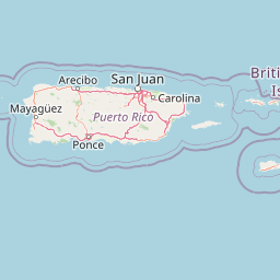
Map view of Bosque del Pueblo

Use this park location map to pinpoint Bosque del Pueblo in Puerto Rico, understand its exact geographic position, and read its mapped placement within the surrounding landscape more clearly.

Pigeon | © OpenStreetMap contributors

Location context for Bosque del Pueblo

Puerto Rico
Park atlas

Compare adjacent mountain reserves and connected regional forest corridors

Explore Other Parks Near Bosque del Pueblo and Surrounding Protected Areas

Browse nearby national parks and protected areas sharing the rugged highland geography of the Cordillera Central. Expand regional park comparison to evaluate connected forest reserves and surrounding watershed habitats.
State or regional parkPuerto Rico
About 10 km away#1 closest

Southwest

Guilarte State Forest: Protected Mountain Ecosystems and Cordillera Central Geography

Highland conservation and mapped mountain terrain in central Puerto Rico

Guilarte State Forest represents a essential protected area in the Cordillera Central of Puerto Rico. The reserve encompasses steep altitudinal shifts, ranging from mid-slope palm forests to summit-level cloud forests. As a headwater region for major river basins, the forest is a focal point for understanding the island's mountainous geography and conservation priorities for endemic species.

Area
19.514 km²
Established
1935
Relief
Mountain
Climate
Tropical
Watercolor painting of a hilly, green landscape featuring rolling mountains in the distance and vegetation in the foreground.
State or regional parkUnited States of America
About 14 km away#2 closest

Southeast

Cerrillos State Forest: Protected Subtropical Woodland and Reservoir Geography

Foothill landscapes and watershed features in Ponce, Puerto Rico

This protected area features a mix of tabonuco forest and water-based recreational terrain. Spanning the slopes of the Cordillera Central foothills, the forest encompasses the Cerrillos River and the man-made Lake Cerrillos reservoir, offering a distinct example of subtropical moist forest ecology within the United States commonwealth system.

Area
0.79 km²
Established
1996
Relief
Upland
Climate
Subtropical
State or regional parkPuerto Rico
About 16 km away#3 closest

East

Los Tres Picachos State Forest: A Geographic Guide to Puerto Rico's Mountain Protected Areas

Cloud forests, volcanic terrain, and watershed protection

Los Tres Picachos State Forest encompasses a striking landscape in the Puerto Rican interior, marked by deep river valleys and its namesake triple peaks. This atlas feature provides insights into the forest's layered ecological zones and its role as a crucial hydrological anchor for the Toro Negro and Cialitos river systems within the Cordillera Central.

Established
1999
Relief
Mountain
Climate
Tropical
Access
Remote access
State or regional parkUnited States of America
About 18 km away#4 closest

North

Río Abajo State Forest: Mapping the Karst Terrain and Protected Landscapes of Puerto Rico

Protected karst landscape and regional forest geography

Río Abajo State Forest serves as an essential example of Caribbean karst ecosystems, defined by its steep limestone mogotes, hidden ravines, and extensive sinkhole networks. Located in the northern karst belt of Puerto Rico, the forest provides deep insight into complex subterranean drainage patterns and serves as a primary hub for endangered species recovery within its uniquely broken, three-dimensional terrain.

Area
14.1 km²
Established
1943
Relief
Upland
Climate
Tropical
A wide watercolor illustration showing a forest scene with trees in the foreground, a winding path or river, and green hills in the background.
Nature reservePuerto Rico
About 31 km away#5 closest

North

Cambalache Forest Reserve: A Detailed Look at Northern Puerto Rico Karst Geography

Protected karst landscape and forest mosaic

Focusing on the rugged limestone mogotes that define the Northern Karst Belt, Cambalache Forest Reserve serves as a vital protected area for endemic flora and fauna. This record provides geographic context on its low-elevation forest structure, the ecological significance of its varied microclimates, and its role as a persistent research site since the mid-twentieth century.

Established
1943
Relief
Upland
Access
Easy access
Scope
Terrestrial
Watercolor painting of a coastal dry forest scene with mangrove-like trees and hills in the background.
State or regional parkPuerto Rico
About 32 km away#6 closest

Southwest

Guánica State Forest: Mapped Geography and Protected Landscapes in Puerto Rico

A diverse Caribbean subtropical dry forest reserve spanning karst terrain and coastal habitats

Guánica State Forest serves as a primary protected natural area in southwestern Puerto Rico, defined by its arid subtropical climate and exceptional ecological diversity. This reserve incorporates a complex mosaic of ecosystems, including deciduous dry forest, mangrove channels, salt flats, and offshore keys. The landscape provides critical habitat for numerous endemic species while preserving the integrity of the Southern Karst geological zone and its surrounding maritime boundaries.

Area
39.97 km²
Established
1919
Relief
Lowland
Climate
Tropical
State or regional parkPuerto Rico
About 32 km away#7 closest

West

Maricao State Forest: A Detailed Map and Geographic Overview of Puerto Rico's Mountain Wilderness

Endemic-rich mountain forests and serpentinite terrain in the Cordillera Central

Maricao State Forest represents a vital protected landscape in the western Cordillera Central of Puerto Rico. This site features distinctive serpentinite geology, complex mountainous watersheds, and diverse endemic bird habitats. The forest serves as a primary geographic anchor along the Ruta Panorámica, providing clear insight into the rugged environmental character of the central island spine.

Area
43.72 km²
Established
1919
Relief
Mountain
Climate
Tropical
A soft watercolor illustration of green hills and foliage against a pale background.
State or regional parkPuerto Rico
About 41 km away#8 closest

Northwest

Guajataca State Forest: Geography and Protected Karst Landscapes in Puerto Rico

Explore the mogotes and cave systems of this regional forest

Guajataca State Forest protects a significant limestone karst landscape in northwestern Puerto Rico. The area is defined by its conical mogote hills, deep sinkhole drainage, and complex cave networks, including the notable Cueva del Viento. As a key part of the regional forest system, it offers a window into the geological and ecological makeup of the Northern Karst belt.

Area
9.26 km²
Established
1943
Relief
Upland
Climate
Tropical

Common questions about visiting, size, designation, and location context for Bosque del Pueblo

Bosque del Pueblo FAQs for park facts, access, geography, and protected area context

Find quick answers about Bosque del Pueblo, including protected-area facts, park geography, trail and visitor context, and how the park fits into its surrounding country and regional landscape.
MoriAtlas Explorer

Continue Your Protected Areas Search Across the Global Atlas

Deepen your exploration by continuing the structured search for national parks and protected areas worldwide. Utilize the comprehensive filtering capabilities to compare different conservation landscapes and refine your understanding of global park geography. Discover more about the distribution and characteristics of protected natural areas.

Global natural geography