Why Chesapeake Bay National Estuarine Research Reserve, Virginia stands out
The reserve is best known for its multi-component design, which captures a full estuarine salinity gradient within a single protected system along the York River. Each component represents a different mix of tidal marsh, upland buffer, island, and open water habitat, allowing scientists to compare how freshwater input, tidal exposure, and shoreline type shape estuarine life. Its position in the southern Chesapeake Bay also gives the reserve a distinctive identity. While the broader Chesapeake is famous worldwide for oysters, blue crabs, and migratory waterfowl, the Virginia portion focuses specifically on how the York River subestuary functions. The reserve is therefore recognized as a primary source of information about York River water quality, shoreline change, marsh ecology, and the response of tidal habitats to regional pressures such as sea-level rise and land use change.
Chesapeake Bay National Estuarine Research Reserve, Virginia history and protected-area timeline
The reserve was established in 1991 as part of the National Estuarine Research Reserve System, a program created to safeguard representative estuarine areas across the United States and to provide living laboratories for long-term ecological research. Its designation marked an expansion of federal recognition for the Chesapeake Bay, which had long been the focus of state-level and interstate conservation efforts due to its biological productivity and its cultural and economic significance.
Since its designation, the reserve has functioned as an ongoing scientific enterprise rather than a one-time land protection action. Its component sites have been used for baseline ecological monitoring, water-quality studies, and investigations of how tidal marshes and island habitats respond to pressures such as nutrient loading, sea-level rise, and shoreline erosion. The reserve's research output has been channeled into the work of the Virginia Institute of Marine Science and into broader Chesapeake Bay restoration efforts, helping bridge local field science with regional and national policy.
Over time, the reserve has also played a growing role in public education and stewardship, supporting programming that introduces the Chesapeake's estuarine environments to students, community groups, and decision makers. While less visible to casual visitors than a traditional national park, it has become a steady institutional presence along the York River.
Chesapeake Bay National Estuarine Research Reserve, Virginia landscape and geographic character
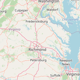
The reserve's physical setting is defined by the lower York River and its transition into the Chesapeake Bay. This is a classic mid-Atlantic estuarine landscape: broad tidal channels, quiet creeks, fringing marshes, low wooded shorelines, and scattered islands rising only a few feet above the waterline. Elevation is low throughout, and the scenery is shaped less by dramatic topography than by the interplay of tides, salinity, and vegetation that reflects the transition from freshwater to saltwater.
The four component sites reflect this landscape through different lenses. Sweet Hall Marsh represents the fresher, upper reaches of the system and is defined by extensive tidal marsh habitat. Taskinas Creek lies further down the salinity gradient and contains a mix of tidal creek, marsh, and forested buffer. Catlett Islands and Goodwin Islands occupy the more saline portion of the system and add island habitat to the reserve, including shorelines that are deeply shaped by wave action and tidal scour.
Together, these landscapes create a layered picture of how a mid-Atlantic estuary looks and functions at different points along its gradient, from quiet freshwater-influenced marsh to open brackish bay.
Chesapeake Bay National Estuarine Research Reserve, Virginia ecosystems, habitats, and plant life
The reserve protects a representative slice of estuarine habitat along one of the Chesapeake Bay's most important tributaries. Its component sites together cover the major habitat types that characterize a mid-Atlantic tidal system: emergent tidal marsh, forested wetland and upland buffers, tidal creeks, shallow open water, and low-lying island shores. These habitats support the high productivity that defines estuaries generally, where nutrient-rich waters fuel dense populations of plants, invertebrates, and fish.
The salinity gradient is the most important ecological organizing principle of the reserve. As fresh water from upriver meets saline water pushed inland from the bay, the plant and animal communities shift accordingly, producing a layered zonation across the four component sites. This makes the reserve unusually useful for understanding how tidal wetlands, submerged aquatic vegetation, and shoreline forests respond to changing conditions across a relatively short geographic distance.
The reserve's ecological value extends to its role as habitat for species that depend on estuaries either year-round or as part of broader life cycles. The combination of marsh edge, shallow water, and forested buffers creates structural diversity that supports feeding, resting, and nursery functions for a wide range of fish, invertebrates, and birds.
Chesapeake Bay National Estuarine Research Reserve, Virginia wildlife and species highlights
Estuarine reserves along the Chesapeake tend to support a particularly rich mix of wildlife because they bring together freshwater, brackish, and marine influences in close proximity. The Virginia reserve is no exception, providing habitat for a variety of fish that use the York River as spawning or nursery grounds, including species of significant commercial and ecological interest to the bay. Tidal creeks and shallow flats offer refuge for crabs, shellfish, and other invertebrates that anchor the estuarine food web.
The reserve's marsh and island components also make it valuable for birds. Tidal marshes host secretive marsh-dependent species, while the more open shorelines and islands provide habitat for wading birds, shorebirds, and waterfowl that either reside in the Chesapeake year-round or pass through during migration. The combination of forested buffers and open water further supports raptors and other predatory species that follow prey movements between habitats.
Because the reserve is positioned within one of the most heavily studied estuaries in North America, much of what is known about its wildlife is documented through long-term monitoring programs. This makes the reserve a key reference site for understanding how wildlife communities in the lower York River respond to environmental change over time.
Chesapeake Bay National Estuarine Research Reserve, Virginia conservation status and protection priorities
The conservation significance of the reserve lies in its combination of habitat protection and applied science. By safeguarding representative estuarine habitat across a full salinity gradient, it preserves sites that can serve as baselines against which other, more degraded areas of the Chesapeake Bay can be measured. The presence of long-term, relatively undisturbed reference sites is a powerful tool for understanding what a healthy York River ecosystem looks like.
The reserve's close partnership with the Virginia Institute of Marine Science and NOAA ensures that its conservation role is tied to active research and monitoring. Data gathered at the reserve inform regional restoration planning, water-quality management decisions, and broader Chesapeake Bay restoration initiatives. Its findings are particularly relevant to questions about nutrient pollution, marsh resilience, shoreline erosion, and the long-term survival of tidal wetlands in the face of sea-level rise.
In a region facing intense pressure from agriculture, development, climate change, and historical pollution, the reserve functions as a stabilizing institutional presence. It keeps attention focused on the smaller-scale, day-to-day ecological dynamics of the York River system, ensuring that conservation planning is grounded in real, ongoing measurement rather than periodic surveys alone.
Chesapeake Bay National Estuarine Research Reserve, Virginia cultural meaning and human context
The York River system carries deep cultural and historical weight in Virginia. It is part of the region where English colonization of North America began, and it remains closely tied to Virginia's identity through its fisheries, waterfront communities, and maritime heritage. The reserve's location within this landscape means that its work is intertwined with a region where the relationship between people and estuarine resources has been active for centuries.
Contemporary culture along the York River continues to revolve around water-dependent livelihoods and recreation, including crabbing, oystering, recreational fishing, and boating. The reserve's educational and stewardship programming reflects this cultural context, engaging communities whose connection to the estuary is both economic and personal. Its research also informs how traditional uses of the river can continue alongside long-term conservation goals.
Top sights and standout views in Chesapeake Bay National Estuarine Research Reserve, Virginia
The reserve's strongest distinguishing feature is its multi-component design, which captures an entire estuarine salinity gradient within a single coordinated network of protected sites. This sets it apart from reserves organized around a single tract and makes it especially valuable for comparative research along the York River.
Equally notable is the institutional structure: a NOAA and Commonwealth of Virginia partnership administered day-to-day by the Virginia Institute of Marine Science. This arrangement ties the reserve directly into one of the most active coastal research institutions on the Chesapeake Bay, ensuring that its protected lands are also active scientific and educational sites.
Best time to visit Chesapeake Bay National Estuarine Research Reserve, Virginia
Seasonal timing strongly shapes the experience of the York River's estuarine environments. Spring and fall are generally when the weather is most moderate for shoreline exploration and when migratory bird activity is at its peak, making these seasons especially rewarding for those interested in birdwatching and observing transitions in marsh and forest life.
Summer brings warmer temperatures and a more active mix of boating, fishing, and outdoor education programs, though humidity and heat are significant in this part of Virginia. Winter offers quieter conditions, cooler temperatures, and an opportunity to observe the estuarine landscape in a calmer state, with waterfowl and wintering bird species visible across open water and marshes. Because the reserve is research-driven, public access is typically oriented around guided programs and learning experiences rather than casual recreation.