Mori Atlas logo
Marine protected areaMallows Bay–Potomac River National Marine Sanctuary

Explore the unique tidal river geography and historic shipwreck ecosystems of the Potomac watershed.

Mallows Bay–Potomac River National Marine Sanctuary: A Mapped Marine Protected Area Landscape

Mallows Bay–Potomac River National Marine Sanctuary encompasses an eighteen square mile tidal stretch of the Potomac River in Charles County, Maryland. This protected landscape is defined by the Ghost Fleet, a collection of over one hundred submerged wooden steamships that have evolved into vegetation covered islands. The sanctuary serves as a vital transition zone where freshwater and tidal habitats converge, creating a complex geography of marshes, submerged aquatic vegetation, and historic maritime archaeological sites.

river sanctuaryshipwrecksGhost Fleettidal riverecotoneChesapeake Bay watershed

Mallows Bay–Potomac River National Marine Sanctuary

Marine protected area

Park overview

Structured park overview, official facts, and landscape profile for Mallows Bay, Potomac River National Marine Sanctuary

Mallows Bay, Potomac River National Marine Sanctuary park facts, protected area profile, and essential visitor context

Review the core facts for Mallows Bay, Potomac River National Marine Sanctuary, including designation, size, terrain, visitor scale, habitats, and operating context in one park-focused overview.

About Mallows Bay, Potomac River National Marine Sanctuary

Mallows Bay–Potomac River National Marine Sanctuary is a National Marine Sanctuary on the tidal Potomac River, stretching from just north of Sandy Point in Charles County, Maryland, southward around Mallows Bay, Blue Banks, and Wades Bay, and across to just north of the mouth of Aquia Creek near Brent Point in Stafford County, Virginia. Within those boundaries, almost all of the river falls on the Maryland side, so the sanctuary sits entirely in Maryland waters. Public access runs through Mallows Bay Park, a Charles County park adjacent to the sanctuary, and through Smallwood State Park to the north, while Widewater State Park in Virginia provides access to the sanctuary's western edge.

The sanctuary's identity is built on three intertwined stories: continents of abandoned ships, deep human history on the Potomac, and an unusually important ecological Transition zone. Its 118 wooden-hulled Ghost Fleet wrecks attract visitors from around the world who come to kayak among the slow-emerging, vegetation-covered vessels as tides rise and fall each day. Beneath and around those wrecks the sanctuary preserves traces of Native American presence dating back roughly 12,000 years, Revolutionary War and Civil War era ship losses, a steamboat and steamship era that reshaped river commerce, and the African American history of the region's 17th-century and later communities.

Ecologically, the sanctuary lies where the freshwater Potomac meets tidal salt influence from the Chesapeake Bay, producing an ecotone with salinity typically between 0.1 and 0.5 parts per thousand but still strongly seasonal and tidal. Submerged aquatic vegetation beds, tidal marshes, and the wreck-formed islands together shelter a broad range of fish, crustaceans, mollusks, birds, mammals, reptiles, amphibians, and insects. NOAA, the State of Maryland, and Charles County jointly manage the sanctuary, with NOAA focused on maritime heritage and the Maryland Department of Natural Resources and the Potomac River Fisheries Commission handling natural-resource management. A 15-member Sanctuary Advisory Council, with seats for two Native American tribes and one Native American nation, advises the superintendent on sanctuary operations.

Quick facts and research context for Mallows Bay, Potomac River National Marine Sanctuary

Mallows Bay–Potomac River National Marine Sanctuary sits on the Maryland shoreline of the tidal Potomac River in Charles County, with its western boundary running along the Maryland-Virginia state line. It is managed jointly by NOAA's Office of National Marine Sanctuaries, the State of Maryland, and Charles County. Its defining identity is the Ghost Fleet of 118 wooden steamships from World War I's Emergency Fleet Corporation, scuttled in Mallows Bay in the 1920s, making it the largest shipwreck fleet in the Western Hemisphere. The sanctuary's waters also function as designated Critical Habitat for the endangered Atlantic sturgeon.

Protection and recognition

Documented marine protection scope, establishment history, and recognition data

Mallows Bay–Potomac River National Marine Sanctuary Protection Status

Mallows Bay–Potomac River National Marine Sanctuary operates under a designated marine protection framework established in 2019. Structured records provide baseline conservation details, historical designation metrics, and administrative governance facts for geographic analysis.

Protection details

Protection scope
Marine
Designated year
2019
Transboundary protection
No
Park context

Deeper park guide and search-rich context for Mallows Bay, Potomac River National Marine Sanctuary

Mallows Bay, Potomac River National Marine Sanctuary history, landscape, wildlife, and travel context

Explore Mallows Bay, Potomac River National Marine Sanctuary through its history, landscape character, ecosystems, wildlife, conservation priorities, cultural context, and seasonal travel timing in a structured park guide built for atlas discovery and search intent.

Why Mallows Bay, Potomac River National Marine Sanctuary stands out

Mallows Bay, Potomac River National Marine Sanctuary is best known internationally for the Ghost Fleet, the 118 World War I-era wooden steamships resting in shallow water in Mallows Bay at the sanctuary's northeastern edge. Built at more than 40 shipyards in 17 states between 1917 and 1919 under the Emergency Fleet Corporation, none of these vessels ever saw combat. After the war they were anchored near Mallows Bay for scrapping, and many were burned to the waterline and scuttled in the bay, where their remains emerged and eroded into vegetation-covered, island-like forms. The sanctuary is also widely recognized for the way the wooden wrecks have been reclaimed by nature, becoming narrow, plant-covered islands that now serve as habitat for ospreys, bald eagles, great blue herons, beavers, and fish. This combination of industrial maritime archaeology and living river ecology, set against the backdrop of the Chesapeake Bay watershed, gives the sanctuary a distinctive identity among America's protected marine places.
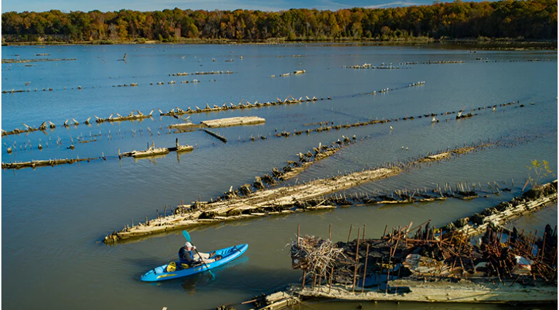
An aerial view of a lone blue kayak paddling through calm water alongside the partially submerged remains of historic wooden ships, with a wooded shoreline in the distance.
A kayaker paddles through the historic Ghost Fleet shipwrecks at Mallows Bay.

Mallows Bay, Potomac River National Marine Sanctuary history and protected-area timeline

The cultural depth of the Mallows Bay–Potomac River National Marine Sanctuary begins long before the Ghost Fleet. Archaeological evidence of human presence along this stretch of the Potomac stretches back approximately 12,000 years, and the area lies within the traditional homelands of the Piscataway people of the Piscataway Conoy Tribe in Maryland and the Patawomeck people of the Patawomeck Indian Tribe of Virginia. The Piscataway identify Mallows Bay and Liverpool Point as places of particular cultural importance, and it is likely that the explorer John Smith visited a village called Nussamek in this vicinity during his 1608 voyage, although no submerged Native archaeological sites have yet been identified within the sanctuary's own waters. From the 17th century onward the area also became part of African American history, with enslaved African Americans and their descendants working, serving in the Civil War, and, in some cases, helping build the very steamships that now lie in Mallows Bay.

The sanctuary's most visible historical layer is the Ghost Fleet. Its 118 wooden-hulled steamships were built between 1917 and 1919 by the Emergency Fleet Corporation at more than 40 shipyards in 17 states, kept largely unused after World War I ended. The Western Marine and Salvage Corporation of Alexandria, Virginia, acquired most of them and used Mallows Bay as a holding area, towing vessels upriver one at a time to strip out scrap metal, steam engines, boilers, and propellers. When the company went bankrupt during the Great Depression, local communities took over informal salvage, and after the U.S. entered World War II, Bethlehem Steel ran a final two-year salvage campaign that ended in 1942. The vessels that survived – after burns, scuttlings, storms, and salvage – became the Ghost Fleet seen today.

Protective recognition came more than half a century later. On April 24, 2015, Mallows Bay was listed on the National Register of Historic Places as part of the Mallows Bay–Widewater Historical and Archeological District, and the National Trust for Historic Preservation named the area a National Treasure. The formal sanctuary effort began on September 16, 2014, when Governor Martin O'Malley submitted a nomination to NOAA on behalf of Maryland, Charles County, and a broad coalition of community groups. After NOAA added the nomination to its eligible inventory in January 2015, ran a public scoping process in late 2015 and early 2016, and weighed four alternative boundaries in 2017, the agency chose an 18-square-mile boundary closely matching the historic district. NOAA, Maryland, and Charles County announced the sanctuary on July 8, 2019, and the designation took effect on September 3, 2019, after the mandatory 45-day congressional review.

Mallows Bay, Potomac River National Marine Sanctuary landscape and geographic character

The sanctuary occupies a roughly 18-square-mile section of the tidal Potomac River, with the Maryland shoreline on the east and the Maryland-Virginia boundary – marked by the mean low-tide line on the Virginia shore – on the west. The eastern boundary follows the Charles County shoreline from near Sandy Point southward past Mallows Bay, Blue Banks, and Wades Bay to Smith Point, while the southern boundary cuts straight across the river near Brent Point and the northern boundary cuts back across north of Tank Creek. Within these limits, the river is generally wide and slow, with shallow edges and intertidal flats along Mallows Bay itself.

The most visually striking landscape feature is the Ghost Fleet itself. The 118 shipwrecks rest in shallow water in the northeastern corner of the sanctuary, and their largely submerged timbers emerge and re-emerge with the tide cycle, sometimes standing several feet above the surface at low tide. Over the decades, sediment and seeds have accumulated inside their hulls, and vegetation has grown over the broken structures. Many wrecks now appear as long, narrow, tree- and shrub-covered islands, sometimes called flowerpot wrecks, while others have fused with the shore to create artificial peninsulas lined with cedar, paw paw, persimmon, and marsh plants.

Along the Maryland shoreline the same Transition-zone character shapes the land. Tidal marshes collect at the mouths of creeks and small streams, broad-leaved emergent plants dominate, and freshwater wetlands fed by beaver-built dams hold open water and floating vegetation. Together, the river edge, the marsh fringe, and the ghostly ship islands give the sanctuary an unusually varied shoreline landscape in which cultural wreckage and natural plant communities have merged into a single setting.

A close up view of an eastern pondhawk dragonfly with a bright blue body and green face resting on a blade of grass.
An eastern pondhawk dragonfly resting on foliage in Mallows Bay.

Mallows Bay, Potomac River National Marine Sanctuary ecosystems, habitats, and plant life

Ecologically, Mallows Bay–Potomac River National Marine Sanctuary sits in a freshwater-to-tidal Transition zone. Daily tides of 1 to 2 feet intrude from the Chesapeake Bay, while fresh water continues to flow in from upstream, leaving the sanctuary's water mostly fresh with salinity that typically ranges from only about 0.1 to 0.5 parts per thousand. That mix of freshwater flow and tidal pulse drives much of the sanctuary's ecological character, supporting submerged aquatic vegetation beds, tidal marshes, and a food web that includes migratory fish, invertebrates, waterfowl, and predatory birds.

Each year from late spring through early fall, the shallow nearshore waters fill with beds of submerged aquatic plants, including coontail, water stargrass, wild celery, and several species of naiad. Approximately ten plant species take part in this yearly growth cycle, and the beds serve as spawning grounds, nurseries, and feeding areas for juvenile fish, crustaceans, and mollusks. At the same time, the tidal marshes at stream mouths host broad-leaved emergent communities of green arrow arum, pickerel weed, spatterdock, jewelweed, wild rice, and the swamp rose-mallow that may have inspired the bay's name, with beaver-built dams and ponds further inland adding cattails, sedges, duckweed, pondweed, and white water lily.

The sanctuary's wrecks play a significant ecological role of their own. Sediment-filled hulls have turned into small islands supporting eastern redcedar, paw paws, persimmon, swamp dogwood, yellow iris, false indigo, and American elm, along with marsh plants such as marsh tickseed and pickerel weed. These wreck-formed habitats provide surface nesting and perching sites for birds; underwater surfaces and cavities shelter fish and invertebrates; and the islands help stabilize portions of the shoreline. Their persistence makes the Ghost Fleet both a cultural and an ecological resource, linking industrial-era maritime history to a living freshwater-Tidal plant-and-animal community.
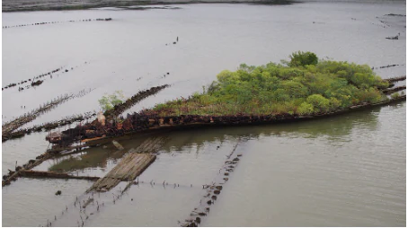
An aerial view of the SS Benzonia and SS Caribou shipwrecks, with hulls covered in lush vegetation resting in the shallow waters of the Potomac River.
Vegetation-covered shipwrecks in Mallows Bay, a signature feature of the Ghost Fleet.

Mallows Bay, Potomac River National Marine Sanctuary wildlife and species highlights

The sanctuary's waters host a community of fish shaped by the Transition-zone mixing of fresh and brackish water. Anglers and researchers regularly encounter channel catfish, blue catfish, largemouth bass, river herring, striped bass, American shad, and Atlantic sturgeon. Among these, the Atlantic sturgeon is the most ecologically significant: it is federally endangered, and the National Marine Fisheries Service has designated the tidal Potomac, including the waters of the sanctuary, as Critical Habitat for the species, recognizing its role as spawning and nursery grounds.

Above and around the shipwrecks, the sanctuary supports a rich bird community. Ospreys return each spring and summer to nest on the wreckage, particularly on the metal-hulled MV Accomac, while bald eagles, great blue herons, and double-crested cormorants use the same structures as perches and feeding stations. Inland from the shore, the tidal marshes and beaver wetlands host amphibians such as spring peepers, American toads, green frogs, and spotted salamanders, together with reptiles including northern watersnakes, northern red-bellied cooters, and eastern box turtles. Mammals such as American beavers and white-tailed deer are active along the shore and just inland, and a beaver lodge has even been documented on one of the wrecked vessels.

Pollinators and other invertebrates round out the community's character. Zebra swallowtail butterflies, eastern pondhawk dragonflies, and bumble bees are part of the regular fauna along the marshes and wetlands, and the sanctuary's submerged aquatic vegetation beds shelter crustaceans and mollusks that, in turn, sustain the fish populations above. Together, these groups make the sanctuary both a key wildlife habitat in the lower Potomac and a popular site for recreational fishing, paddling, and birdwatching.
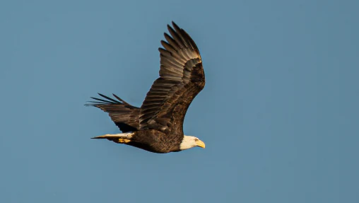
A bald eagle with wings spread in flight against a clear blue sky.
A bald eagle in flight over Mallows Bay.

Mallows Bay, Potomac River National Marine Sanctuary conservation status and protection priorities

Mallows Bay–Potomac River National Marine Sanctuary was created with an unusually broad conservation mandate that links natural-resource protection, cultural heritage, and water-quality monitoring. Designated in 2019 as the fourteenth National Marine Sanctuary in the United States, it is also the first such sanctuary in the Chesapeake Bay watershed and the first to be designated since 2000, reflecting recognition of the area's national significance. NOAA's primary conservation focus is on maritime heritage, anchored by the 118 shipwrecks of the Ghost Fleet, while the Maryland Department of Natural Resources and the Potomac River Fisheries Commission lead natural-resource management, and Charles County partners on community access.

The sanctuary's waters carry formal ecological designations as well. The National Marine Fisheries Service has designated much of the tidal Potomac, including the sanctuary, as Critical Habitat for the endangered Atlantic sturgeon, giving the sanctuary a federal role in spawning and nursery protection for a species that depends on the freshwater-to-brackish environment the sanctuary preserves. In the surrounding tidal marshes, beaver-built dams and emergent wetland vegetation stabilize the shore, absorb nutrients from runoff, and reduce erosion and flooding. NOAA also partners with the Smithsonian Environmental Research Center, the Mid-Atlantic Acoustic Telemetry Observation System, the Chesapeake Bay SAV Watchers, the National Marine Sanctuary Foundation, and the Potomac Riverkeeper Network to monitor water quality, fish movements, submerged aquatic vegetation, and bacterial contamination – all of which directly inform ongoing ecological restoration and historical preservation work in the sanctuary.

Climate change is now a central concern. A NOAA study published in November 2020 outlined projected warming of air and water, sea-level rise driven by both ocean rise and shoreline subsidence, larger storm surges, more frequent flooding, ocean acidification, and the potential spread of invasive species – all of which could accelerate the biological and chemical deterioration of the Ghost Fleet's wooden and steel wrecks. Identifying these threats early is part of why the sanctuary's monitoring infrastructure, including the seasonal water-quality buoy in Mallows Bay, is treated as a long-term conservation investment rather than a short-term observation project.

Mallows Bay, Potomac River National Marine Sanctuary cultural meaning and human context

The Mallows Bay–Potomac River National Marine Sanctuary is a place where several cultural histories overlap in a single piece of river. The Piscataway people of the Piscataway Conoy Tribe in Maryland and the Patawomeck people of the Patawomeck Indian Tribe of Virginia hold this stretch of the Potomac as part of their ancestral homelands, and the Piscataway identify Mallows Bay and Liverpool Point as sites of particular cultural importance. Explorer John Smith's 1608 visit likely brought him to a Piscataway-area village called Nussamek on or near this coast. Archaeological evidence of human presence here stretches back an estimated 12,000 years, although no submerged Native archaeological sites have yet been documented within the sanctuary's waters.

Layered above that deep Indigenous heritage are the histories of European colonization, the African American experience, and American industrial and military history. African Americans arrived on these shores as enslaved people and have remained part of the area's history ever since, serving in the American Civil War and contributing to the construction of some of the very steamships that now rest in Mallows Bay. Revolutionary War and Civil War era wrecks lie in or near the sanctuary, while 20th-century industrial history is embodied in the Emergency Fleet Corporation ships scrapped and scuttled after World War I. Mallows Bay's place on the National Register of Historic Places since 2015 as part of the Mallows Bay–Widewater Historical and Archeological District, and the National Trust for Historic Preservation's designation of the area as a National Treasure, formalize this cultural significance, and the sanctuary is now part of the Southern Maryland National Heritage Area.
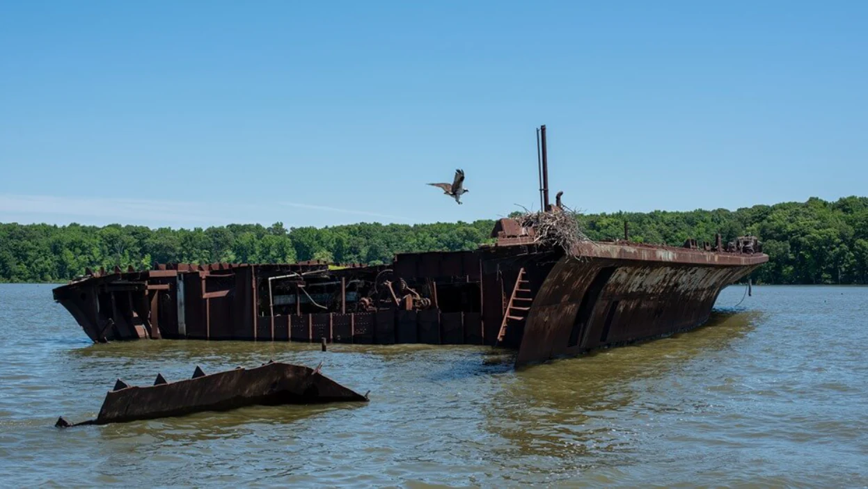
An osprey in flight nears its nest on the stern of a large, rusted shipwreck partially submerged in water, with a dense treeline in the background.
An osprey approaches a nest atop the SS Accomac shipwreck, part of the Ghost Fleet in Mallows Bay.

Top sights and standout views in Mallows Bay, Potomac River National Marine Sanctuary

Mallows Bay–Potomac River National Marine Sanctuary's standout feature is the Ghost Fleet – the 118 wooden-hulled steamships of the World War I-era Emergency Fleet Corporation that rest in shallow water at the sanctuary's northeastern edge and constitute the largest shipwreck fleet in the Western Hemisphere. Many of these wrecks have evolved, over a century, into vegetation-covered islands that now host nesting ospreys, perching bald eagles, and even beaver lodges, so visiting the sanctuary means seeing maritime archaeology and living river habitat at the same time. The sanctuary is also remarkable for the sheer depth of its cultural record, from roughly 12,000-year-old evidence of human presence to contemporary Native American tribal stewardship of the river, layered with Revolutionary War, Civil War, African American, and industrial-era history that all converge in a single 18-square-mile stretch of the tidal Potomac. Combined with a freshwater-to-tidal Transition zone that supports Atlantic sturgeon and a wide range of resident and migratory wildlife, these qualities make the sanctuary a uniquely concentrated example of how natural and cultural heritage can be protected together.
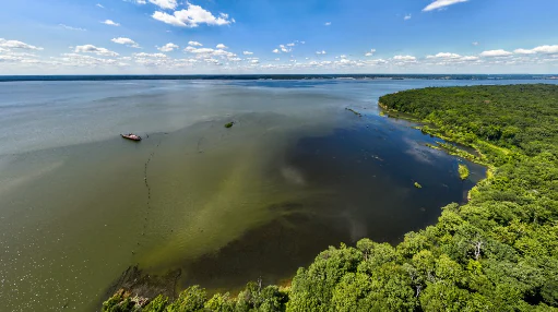
Aerial view of the Mallows Bay shoreline featuring dense green forest bordering the Potomac River, with visible historic shipwrecks partially submerged in the water under a clear blue sky.
An aerial view of the Mallows Bay shoreline on the Potomac River, highlighting the area's lush forest and open water where historic shipwrecks are located.
Monthly climate preview

Long-term representative point measurements tracking annual temperature and precipitation rhythm

Mallows Bay–Potomac River National Marine Sanctuary Climate Normals and Weather by Month

Representative coordinates record measured monthly temperature ranges and precipitation averages across a thirty-year climatology period. Examining the complete twelve-month dataset reveals detailed long-term climate normals for Mallows Bay–Potomac River National Marine Sanctuary.
Annual mean13 °C
0 °C26 °C
Jan
Feb
Mar
Apr12°
May18°
Jun23°
Jul26°
Aug25°
Sep21°
Oct14°
Nov
Dec
Warmest month
July

25.8 °C

Coolest month
January

0.4 °C

Wettest month
September

3.8 mm/day

Driest month
February

2.5 mm/day

Park location guide

Geography guide, regional context, and park location map for Mallows Bay, Potomac River National Marine Sanctuary

Mallows Bay, Potomac River National Marine Sanctuary park geography, regions, and map view in United States of America

Understand where Mallows Bay, Potomac River National Marine Sanctuary sits in United States of America through a broader geographic reading of the surrounding landscape, nearby location context, and its mapped position within the national park landscape.

How Mallows Bay, Potomac River National Marine Sanctuary fits into United States of America

The United States of America is a federal presidential republic and one of the world's largest countries by area and population. It consists of 50 states across a vast territory spanning multiple time zones, with its capital in Washington, D.C. and largest city in New York City. The nation has a diverse economy, influential political system, and significant cultural and military presence globally.

Wider geography shaping Mallows Bay, Potomac River National Marine Sanctuary in United States of America

The United States occupies a vast territory in North America, bordered by Canada to the north and Mexico to the south. The 48 contiguous states stretch from the Atlantic to the Pacific Ocean, while Alaska occupies the northwestern region and Hawaii is an archipelago in the Pacific. The country encompasses diverse terrain including the Rocky Mountains, Appalachian Mountains, Great Plains, and extensive river systems.

Map view of Mallows Bay, Potomac River National Marine Sanctuary

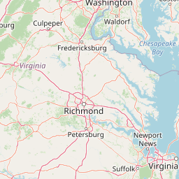
Use this park location map to pinpoint Mallows Bay, Potomac River National Marine Sanctuary in United States of America, understand its exact geographic position, and read its mapped placement within the surrounding landscape more clearly.

Pigeon | © OpenStreetMap contributors

Location context for Mallows Bay, Potomac River National Marine Sanctuary

Charles CountyMaryland

Visualizing the Ghost Fleet, tidal river habitats, and protected maritime scenery

Mallows Bay–Potomac River National Marine Sanctuary Photos and Visual Landscape Exploration

Photographic collections reveal the complex terrain of Mallows Bay–Potomac River National Marine Sanctuary, highlighting submerged wooden shipwrecks and dynamic tidal marshes. Visual inspection of these protected waters provides clear insight into how industrial maritime history merges with living river ecosystems.

An aerial view of a lone blue kayak paddling through calm water alongside the partially submerged remains of historic wooden ships, with a wooded shoreline in the distance.

A medium shot of a rusted ship bow rising from the water, with an osprey bird sitting on a large nest built on the deck, against a background of a forest shoreline.

A close up view of an eastern pondhawk dragonfly with a bright blue body and green face resting on a blade of grass.

An aerial view of the SS Benzonia and SS Caribou shipwrecks, with hulls covered in lush vegetation resting in the shallow waters of the Potomac River.

A bald eagle with wings spread in flight against a clear blue sky.

A close up view of an osprey bird with brown and white feathers perched on a messy nest made of sticks against a soft, blurred background.

An osprey in flight nears its nest on the stern of a large, rusted shipwreck partially submerged in water, with a dense treeline in the background.

Aerial view of the Mallows Bay shoreline featuring dense green forest bordering the Potomac River, with visible historic shipwrecks partially submerged in the water under a clear blue sky.

A high-angle view showing a row of many colorful kayaks lined up on a narrow, sandy beach next to a river with a wooded bank in the background.

A peaceful, shallow wetland area surrounded by lush green trees and grasses, with reflections of the forest canopy visible in the calm, dark water.

A winding, narrow creek snakes through a vibrant green tidal marsh surrounded by dense deciduous forest under a bright sky.

An aerial view showing a kayaker paddling through shallow water near several partially submerged, decaying wooden shipwrecks forming part of the Ghost Fleet at Mallows Bay.

A close-up of a pink hibiscus flower with a yellow center and green bud, surrounded by blurred green wetland foliage.

An aerial view shows multiple historic, partially submerged shipwrecks overgrown with vegetation in the calm, reflective waters of Mallows Bay, backed by a dense green forest.

Close up view of green eastern redcedar foliage covered in small water droplets and pale, rounded berries.

An eastern box turtle with a patterned yellow and brown shell partially hidden behind green leaves and grass.

Park atlas

Compare adjacent tidal river corridors, wetland reserves, and protected maritime landscapes.

Parks Near Mallows Bay–Potomac River National Marine Sanctuary and Regional Protected Areas

Browsing nearby protected areas allows travelers to uncover connected river ecotones, tidal marshes, and regional habitats beyond Mallows Bay–Potomac River National Marine Sanctuary. Expanding the search across the surrounding watershed provides deeper geographic context for coastal and marine conservation lands.
Watercolor painting of rolling hills, trees, and a river in a scenic landscape
National parkVirginia
79 km away#1 closest

West

Shenandoah National Park: National Park Protected Landscape and Geography

Mapped terrain and protected area context in Virginia.

Shenandoah National Park is a designated national park in Virginia, offering a rich exploration of its protected landscape and geographic features. This page provides detailed atlas-oriented information, focusing on the park's mapped boundaries and its role within the regional geography. Discover the natural terrain and spatial identity of this important US protected area, ideal for understanding park landscapes.

Area
811.176 km²
Established
1935
IUCN
II
Visitors
1.7M annual
Nature reserveVirginia
About 117 km away#2 closest

Southeast

Chesapeake Bay National Estuarine Research Reserve, Virginia: Coastal and Estuarine Atlas

Mapped protected landscapes of the York River estuary.

Spanning the critical salinity gradient of the York River, this nature reserve integrates diverse tidal habitats including expansive marshes, quiet creeks, and coastal islands. As a center for scientific monitoring, the reserve offers a layered view of Mid-Atlantic estuarine geography, protecting essential buffers and water channels that define the lower Chesapeake Bay region.

Established
1991
Relief
Lowland
Climate
Temperate
Access
Access unknown
Watercolor illustration depicting a serene mountain landscape with a winding river, rolling hills, and scattered trees against a light background.
Protected landscapeVirginia
About 146 km away#3 closest

West

George Washington and Jefferson National Forests: Appalachian Protected Landscape Mapping

Explore mountain ridges, river valleys, and wilderness corridors in Virginia.

Covering one of the largest public forest blocks in the eastern United States, George Washington and Jefferson National Forests offer a unique look at the central Appalachian mountain terrain. The area includes extensive wilderness tracts, the Appalachian Trail corridor, and significant geological landmarks like the Breaks gorge. Analyze the protected landscape boundaries and topographic features that define this major regional watershed and forest network.

Area
7,247.65 km²
Established
1995
Relief
Mountain
Climate
Temperate
Wildlife reserveNelson County
162 km away#4 closest

Southwest

Priest Wilderness: A Deep Dive Into Appalachian Mountain Geography and Protected Forest Boundaries

High elevation ridge terrain in Nelson County, Virginia.

Priest Wilderness stands as a signature protected area in the Blue Ridge Mountains, defined by a dramatic 3,000 foot vertical gain and dense, mature hardwood forests. This documentation maps the rugged ridge and hollow topography that characterizes one of the most significant wilderness sections along the central Appalachian trail corridor.

Area
23.17 km²
Established
2000
IUCN
Ib
Relief
Mountain
Watercolor painting showing layers of soft green hills and mountain ridges fading into a light hazy background.
Protected landscapeWest Virginia
171 km away#5 closest

West

Monongahela National Forest: Protected Appalachian Landscapes and Regional Geography

Mapping West Virginia wilderness and mountain terrain

Monongahela National Forest protects nearly one million acres of the central Appalachian Mountains. This massive federally managed landscape is defined by the Allegheny Front, the highest peak in the Allegheny range at Spruce Knob, and iconic geological formations like Seneca Rocks. The region represents a vital intersection of climate, hydrology, and biodiversity in the eastern United States, housing eight distinct wilderness areas and complex high-altitude ecosystems.

Area
3,727.8 km²
Established
1920
Visitors
3M annual
Relief
Mountain
Nature reserveDelaware
About 172 km away#6 closest

Northeast

Delaware National Estuarine Research Reserve: Coastal Estuary and Wetland Protected Landscape

A paired nature reserve system in Delaware

Delaware National Estuarine Research Reserve preserves a significant coastal gradient across two distinct units in Kent County. From the freshwater wetlands and forests of Blackbird Creek to the tidal salt marshes of the St. Jones River, this protected area serves as a primary hub for estuarine research, monitoring aquatic conditions, and safeguarding biodiversity within the Delaware Bay ecological corridor.

Established
1937
IUCN
IV
Relief
Lowland
Climate
Temperate
A minimalist watercolor painting depicting a soft green and pastel landscape with rolling hills and a central pond or marshy area on a white background.
Protected landscapeMaryland
176 km away#7 closest

East

Assateague Island National Seashore: Geographic Atlas and Protected Landscape Overview

Dynamic barrier island terrain in the Maryland region

Assateague Island National Seashore preserves one of the most naturally functioning barrier island ecosystems in the Mid-Atlantic. This protected stretch of coastline showcases the interaction between sediment movement, storm-driven overwash, and salt marsh development, offering a clear view of how barrier systems respond to environmental forces.

Area
167.2 km²
Established
1965
IUCN
V
Visitors
2.3M annual
A soft watercolor illustration depicting a stream flowing through a forested valley with mountain ridgelines in the background.
Wildlife reserveUnited States of America
About 177 km away#8 closest

West

Ramseys Draft Wilderness: Appalachian Ridge and Valley Protected Landscape and Map Atlas

Examining wilderness boundaries and mountain stream geography in Virginia

Located in western Virginia, Ramseys Draft Wilderness is a federal protected area characterized by its extreme vertical relief and rugged Appalachian topography. Spanning from the main crest of Shenandoah Mountain to the valley floor, this wilderness serves as a vital corridor for high-elevation forest ecosystems, native brook trout, and neotropical migrant birds.

Area
26.38 km²
Established
1984
Relief
Mountain
Climate
Temperate

Common questions about visiting, size, designation, and location context for Mallows Bay, Potomac River National Marine Sanctuary

Mallows Bay, Potomac River National Marine Sanctuary FAQs for park facts, access, geography, and protected area context

Find quick answers about Mallows Bay, Potomac River National Marine Sanctuary, including protected-area facts, park geography, trail and visitor context, and how the park fits into its surrounding country and regional landscape.
MoriAtlas Explorer

Continue Your Protected Areas Search Across the Global Atlas

Deepen your exploration by continuing the structured search for national parks and protected areas worldwide. Utilize the comprehensive filtering capabilities to compare different conservation landscapes and refine your understanding of global park geography. Discover more about the distribution and characteristics of protected natural areas.

Global natural geography