
Mori Atlas logo
Protected landscapeAssateague Island National Seashore

Mapping the geographic transitions of ocean beaches, salt marshes, and maritime forests

Assateague Island National Seashore: A Protected Atlantic Barrier Island Landscape in Maryland

Assateague Island National Seashore encompasses a remarkably resilient barrier island system along the Atlantic coast of Maryland and Virginia. This protected landscape is defined by its geological mobility, with dunes and shorelines continuously reshaped by tidal currents and storm events. Across its narrow width, the area transitions from broad sandy ocean beaches to sheltered salt marshes and tidal creeks, providing a critical mosaic of habitats for coastal wildlife and migratory bird species.

barrier islandAtlantic coastcoastal seashoresalt marshocean beachdune habitat
Digital vector illustration of a scenic coastline featuring a sandy beach, turquoise water, evergreen trees in the foreground, and cliffs in the distance under a pale sun.

Assateague Island National Seashore

Protected landscape

Park overview

Structured park overview, official facts, and landscape profile for Assateague Island National Seashore

Assateague Island National Seashore park facts, protected area profile, and essential visitor context

Review the core facts for Assateague Island National Seashore, including designation, size, terrain, visitor scale, habitats, and operating context in one park-focused overview.

About Assateague Island National Seashore

Assateague Island National Seashore sits on the seaward edge of the Delmarva Peninsula, where the Atlantic Ocean meets a long chain of barrier islands stretching from New England to the Gulf Coast. The park's core is a roughly 37-mile-long barrier island that never exceeds about a mile in width, flanked by open ocean beaches on the east and the quieter waters of Chincoteague and Sinepuxent Bays on the west. Because major development never took hold, the island retains much of the natural character that once defined the Atlantic shoreline.

The unit is divided into two cooperating districts. The Maryland District is managed directly by the National Park Service and contains the main visitor center on the mainland, the Verrazano Bridge access, campgrounds, lifeguarded beaches, nature trails, and park headquarters. The Virginia District overlays part of the Chincoteague National Wildlife Refuge, where the U.S. Fish and Wildlife Service manages habitat and the National Park Service operates a recreational beach zone under a formal partnership agreement. Together these areas present the public with a comprehensive barrier island experience spanning ocean, dunes, maritime forest, and salt marsh.

Ecologically, Assateague is a textbook example of a Mid-Atlantic barrier island. Sands carried southward from the eroding Appalachian Mountains feed the island through longshore drift, while storms and rising sea levels push the entire system slowly westward. This active reshaping of the landscape creates a mosaic of habitats: open sandy beaches, primary and secondary dunes, shrub thickets, small maritime forest patches, expansive salt marshes, and subtidal bay waters. The combination supports an unusually full community of coastal species for such a narrow strip of land.

Culturally and recreationally, Assateague offers one of the most accessible wilderness-feeling coastal experiences on the U.S. East Coast. Visitors come for swimming, surfing, saltwater fishing, wildlife observation, paddling in the bay, and backcountry camping, along with ranger programs that interpret barrier island processes. The park's famous wild horses, the Chincoteague ponies on the Virginia side and a separate, independently managed herd in Maryland, have become emblematic of the seashore and are central to its public identity.

Quick facts and research context for Assateague Island National Seashore

Assateague Island National Seashore is a federally protected unit of the U.S. National Park Service located on a roughly 37-mile-long barrier island off the Atlantic coast of Maryland and Virginia. It was authorized in 1965 and signed into law by President Lyndon B. Johnson that same year. The seashore preserves one of the largest relatively undeveloped barrier island ecosystems remaining in the Middle Atlantic states and is administered alongside Assateague State Park and the adjacent Chincoteague National Wildlife Refuge.

Protection and recognition

Examine the terrestrial protection parameters and management scope for this coastal landscape.

Assateague Island National Seashore Protection Status and Conservation Scope

Assateague Island National Seashore maintains a documented terrestrial protection framework outlining its management scope and conservation boundaries. Structured administrative metrics provide clear reference points for evaluating the governance history and official designation parameters governing the region.

Protection details

Protection scope
Terrestrial
Transboundary protection
No
Park context

Deeper park guide and search-rich context for Assateague Island National Seashore

Assateague Island National Seashore history, landscape, wildlife, and travel context

Explore Assateague Island National Seashore through its history, landscape character, ecosystems, wildlife, conservation priorities, cultural context, and seasonal travel timing in a structured park guide built for atlas discovery and search intent.

Why Assateague Island National Seashore stands out

Assateague Island National Seashore is best known for its free-roaming wild horses and for protecting one of the longest stretches of naturally functioning Atlantic barrier island in the heavily populated Mid-Atlantic region. The island's two distinct feral horse herds, separated by the Maryland-Virginia state line, have become cultural symbols, while the surrounding dunes, salt marshes, and ocean beaches draw visitors interested in birdlife, surf fishing, and barrier island geology. The park is also recognized for the visible geological dynamics of a barrier island system, including ongoing beach rollover, overwash during nor'easters, and the longshore movement of sand southward from Appalachian sediment sources. This combination of distinctive wildlife and a physically active coastal landscape gives Assateague a strong and memorable identity among U.S. National Seashores.
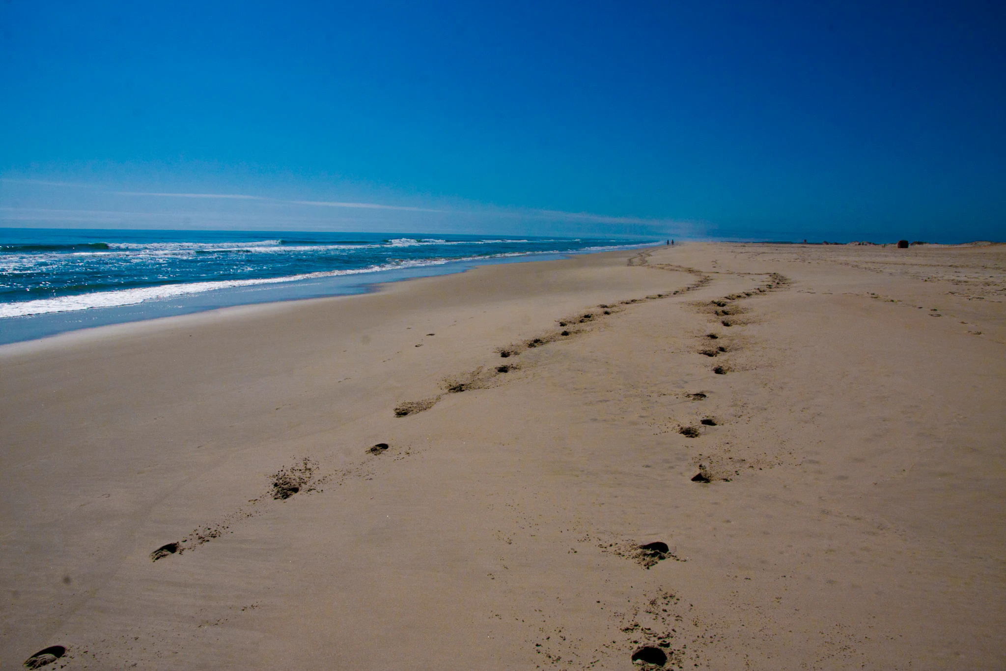
A wide view of a sandy beach at Assateague Island, with footprints in the sand leading towards the horizon and the Atlantic Ocean waves on the left.
Footprints stretch along the expansive sandy beach at Assateague Island National Seashore.

Assateague Island National Seashore history and protected-area timeline

Assateague Island National Seashore was authorized by an act of the 89th United States Congress and signed into law by President Lyndon B. Johnson on September 21, 1965, following a legislative effort led by Senator Daniel Brewster of Maryland. The authorization came after the island had already narrowly escaped large-scale private development, and the park stands as a direct outcome of mid-twentieth-century conservation efforts to preserve remaining stretches of undeveloped Atlantic shoreline.

In the 1950s, a private firm had zoned and sold roughly 5,000 lots on what is now park land for a planned resort community called Ocean Beach, Maryland. Early roads and structures were constructed, but the Ash Wednesday Storm of 1962, a powerful nor'easter, devastated the island, destroyed the few existing buildings, and ripped apart the road network. The storm demonstrated that the island's natural instability made it a poor site for dense development, and the firm ultimately sold its land to the federal government, clearing the way for federal protection.

The Ocean City Inlet itself was created during the 1933 Chesapeake-Potomac hurricane, which separated Fenwick Island from Assateague, and jetties built afterward helped stabilize that boundary. Later storm events, including severe nor'easters in 1998, led to sand replenishment programs at the northern end of the island to counteract erosion caused by the Ocean City jetties starving Assateague of new sand. Over time, the National Park Service has added a modern mainland visitor center (built in 2010), a solar-powered island contact station, designated trail networks, and organized over-sand vehicle zones, while the feral horse herds have been managed with different strategies on each side of the state line.

Assateague Island National Seashore landscape and geographic character

Assateague Island is a long, narrow Atlantic barrier island shaped continuously by wind, waves, and storms. The island is roughly 37 miles long but never more than about a mile wide, creating an elongated strip of sand and marsh between the open ocean to the east and the protected waters of Sinepuxent Bay and Chincoteague Bay to the west. This narrow cross-section produces a striking sequence of coastal environments within a very short walking distance.

The eastern side of the island consists of broad sandy beaches backed by primary dunes, with secondary dunes and low swales inland. Overwash during nor'easters and hurricanes regularly pushes sand across the island, gradually migrating the entire system westward. A series of jetties at Ocean City Inlet has stabilized the islands to the north but has reduced the natural sand supply reaching Assateague, accelerating erosion at the northern end and prompting periodic beach replenishment projects.

On the bay side, the landscape transitions into expansive salt marshes, tidal creeks, small marsh islands, and sheltered shallows. A boardwalk trail gives visitors an elevated view across this marsh mosaic. Patches of maritime forest and shrub thicket occupy higher, more sheltered portions of the island, while small back-bay peninsulas and shallow bays provide the setting for backcountry camping and paddling routes. Together, the ocean, dune, forest, and marsh zones form a compact and visually dynamic coastal landscape.

Underlying this scenery is an active geological story in which sand ultimately traces back to erosion in the Appalachian Mountains, carried south through longshore drift to feed beaches along the entire Eastern Seaboard. The result is a landscape that is not static; sand moves, dunes shift, marshes expand and contract, and the island as a whole responds to climate-driven changes in sea level and storm frequency.

Assateague Island National Seashore ecosystems, habitats, and plant life

Assateague Island National Seashore protects a full suite of Mid-Atlantic barrier island habitats within its boundaries. Ocean beach, primary and secondary dunes, low swales, maritime shrub thickets, small maritime forest stands, and extensive salt marsh all occur in close proximity, creating high habitat diversity across a very narrow strip of land. Adjacent bay waters add estuarine and subtidal habitats that are integral to the park's ecological character.

Salt marsh is one of the system's defining habitats. The boardwalk-protected marsh trail offers a representative view of tidal creeks, marsh grasses, and the rich invertebrate communities that fuel the food web of the surrounding bays. These marshes also act as a buffer against storms, filter runoff, and provide critical nursery habitat for fish and shellfish that later support recreational fisheries in the area. The interaction between dune and marsh plant communities, including beach grass on the ocean side and cordgrass-dominated marsh on the bay side, illustrates how the island's environments grade from one into another.

Vegetation plays a strong role in stabilizing the island. Dune grasses and foredune plants help anchor shifting sands, while shrubs and small trees create the more sheltered interior zones. The park's forest trail passes through one of these woodland pockets, demonstrating how even limited tree cover can create a distinctly cooler, shadier microclimate compared with the open beach. The combination of these plant communities supports a wide array of bird, mammal, and insect life across the seasons.

Assateague Island National Seashore wildlife and species highlights

Wildlife is one of the central attractions of Assateague Island National Seashore. The park's beaches, dunes, marshes, and bay waters host a wide variety of birds, from breeding shorebirds to wintering waterfowl and seasonal migrants. The combination of habitats within a small geographic area makes the seashore a productive birding destination throughout the year.

Shorebirds and wading birds are especially prominent. Piping plovers breed on the island and are federally protected as a threatened species, with seasonal closures of parts of the beach and over-sand vehicle zone used to protect nesting areas and chicks. Other breeding species include great egrets and red-winged blackbirds, while seasonal visitors and residents range from brown pelicans and various gulls and terns along the ocean to woodland species like ruby-crowned kinglets and white-eyed vireos in the interior thickets. In winter, brant geese and northern saw-whet owls join the community, expanding the park's birdlife identity across the seasons.

The park's most famous fauna are its feral horses. Two herds roam the island: a Virginia herd owned and managed by the Chincoteague Volunteer Fire Company, famous for the annual Pony Penning roundup and swim to Chincoteague Island, and a Maryland herd treated as wildlife and managed by the National Park Service through a fertility-control vaccine known as PZP. These horses, often called Chincoteague ponies or Assateague horses, are descendants of domestic stock, and their small stature is attributed to the low-nutrient, salty diet of marsh grasses rather than to true pony parentage.

Although the horses are a major draw, they are wild animals; rangers enforce a buffer distance and prohibit feeding or petting. Beyond horses and birds, the marshes and bay waters support crabs, fish, and other estuarine species that underpin the park's recreational fishing opportunities and connect Assateague's wildlife story to the broader Chesapeake and Mid-Atlantic coastal ecosystems.

Assateague Island National Seashore conservation status and protection priorities

Assateague Island National Seashore was established through federal legislation in 1965 explicitly to protect a stretch of undeveloped Atlantic shoreline at a moment when coastal development was rapidly consuming the Mid-Atlantic landscape. Its designation as a National Seashore under the National Park Service places it within a category of protected areas intended to preserve nationally significant coastal resources while providing public access. The park's stated mission emphasizes preserving coastal resources and the natural ecosystem processes on which they depend, alongside compatible recreation and public education.

Conservation significance at Assateague centers on its role as one of the largest relatively intact barrier island ecosystems in the Middle Atlantic states. The island's continuous ocean-to-bay habitat gradient supports breeding populations of threatened species such as piping plovers, and protections tied to the Endangered Species Act shape seasonal management, including beach and OSV closures during nesting periods. Management of the Maryland horse herd through fertility control, rather than roundups or veterinary intervention, reflects an approach that prioritizes the animals as a self-sustaining wildlife population within a protected ecosystem.

The park also serves as a living laboratory for barrier island conservation in the face of sea-level rise and increasing storm intensity. Visible processes including beach rollover, dune migration, overwash, and salt marsh expansion illustrate how barrier islands respond to climate pressures. Management responses ranging from jetty-related sand replenishment at the northern end to protective seasonal closures and habitat-based restrictions on recreation all reflect ongoing efforts to balance ecosystem integrity with public use.

Assateague Island National Seashore cultural meaning and human context

Assateague Island sits within a coastal region with a long history of human interaction with the Delmarva shoreline, including fishing communities, bay-dependent livelihoods, and a strong tradition of maritime culture on both the Maryland and Virginia sides. The Chincoteague Volunteer Fire Company's annual Pony Penning event, in which the Virginia herd is rounded up and swum across the channel to Chincoteague Island, has become a defining cultural tradition of the region and a major draw for visitors interested in local heritage.

The island itself is also a place where the failure of mid-twentieth-century resort development shaped its modern identity. The unrealized Ocean Beach, Maryland subdivision, the remnants of Baltimore Boulevard, and the abandoned roads and lots stand as reminders of a moment when the Atlantic shoreline was heavily marketed for private building. The Ash Wednesday Storm of 1962, which ultimately ended development plans and cleared the way for federal protection, has itself become part of the island's narrative, marking the transition from speculative real estate to permanent conservation.

Top sights and standout views in Assateague Island National Seashore

Assateague Island National Seashore's strongest distinguishing features include its status as one of the largest naturally functioning Mid-Atlantic barrier islands, its iconic free-roaming horses, and its dense concentration of coastal habitats within a compact footprint. The park offers a rare chance to experience an Atlantic shoreline that still responds to wind, waves, and storms in a largely unimpeded way.

Equally important are the park's birdlife, especially breeding piping plovers and seasonal concentrations of migratory and wintering species, and its public access infrastructure, including a mainland visitor center, lifeguarded beaches, short interpretive trails through marsh, forest, and dune habitats, and a regulated over-sand vehicle zone. The cooperative management arrangement with the Chincoteague National Wildlife Refuge on the Virginia side adds to the park's distinctive character, blending National Park Service recreation with U.S. Fish and Wildlife Service habitat protection across a single barrier island.

Best time to visit Assateague Island National Seashore

Assateague Island National Seashore is a year-round destination, but its character shifts significantly with the seasons. Summer brings warm ocean water, lifeguarded beaches, active ranger programs, and the busiest visitor periods; this is also when biting insects are most numerous in the marshes and when seasonal closures may be in effect to protect nesting piping plovers and their chicks. Late spring and early fall often offer milder temperatures, fewer insects, and a more relaxed atmosphere on the island.

Winter and early spring attract visitors interested in birdlife, including brant geese and northern saw-whet owls, as well as those drawn to the stormy character of the Atlantic coast, when nor'easters reshape beaches and dunes. Beach replenishment work, wildlife closures, and reduced services outside the main visitor season can affect specific activities, so visitors interested in particular experiences, such as Pony Penning events in Virginia, over-sand vehicle access, or peak birdwatching, will find different windows of opportunity across the year.
Monthly climate preview

Long-term temperature and precipitation records across twelve months of baseline data

Assateague Island National Seashore Climate and Average Temperatures by Month

Representative coordinate records show measured monthly mean temperatures ranging from 4.77 degrees Celsius to 24.67 degrees Celsius alongside steady daily precipitation amounts. Exploring the full twelve-month profile provides complete visibility into long-term climate normals and annual weather patterns for this protected coastal location.
Annual mean14 °C
5 °C25 °C
Jan
Feb
Mar
Apr11°
May16°
Jun21°
Jul25°
Aug25°
Sep22°
Oct17°
Nov12°
Dec
Warmest month
July

24.7 °C

Coolest month
February

4.8 °C

Wettest month
August

4.1 mm/day

Driest month
May

2.7 mm/day

Park location guide

Geography guide, regional context, and park location map for Assateague Island National Seashore

Assateague Island National Seashore park geography, regions, and map view in United States of America

Understand where Assateague Island National Seashore sits in United States of America through a broader geographic reading of the surrounding landscape, nearby location context, and its mapped position within the national park landscape.

How Assateague Island National Seashore fits into United States of America

The United States of America is a federal presidential republic and one of the world's largest countries by area and population. It consists of 50 states across a vast territory spanning multiple time zones, with its capital in Washington, D.C. and largest city in New York City. The nation has a diverse economy, influential political system, and significant cultural and military presence globally.

Wider geography shaping Assateague Island National Seashore in United States of America

The United States occupies a vast territory in North America, bordered by Canada to the north and Mexico to the south. The 48 contiguous states stretch from the Atlantic to the Pacific Ocean, while Alaska occupies the northwestern region and Hawaii is an archipelago in the Pacific. The country encompasses diverse terrain including the Rocky Mountains, Appalachian Mountains, Great Plains, and extensive river systems.

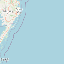
Map view of Assateague Island National Seashore

Use this park location map to pinpoint Assateague Island National Seashore in United States of America, understand its exact geographic position, and read its mapped placement within the surrounding landscape more clearly.

Pigeon | © OpenStreetMap contributors

Location context for Assateague Island National Seashore

MarylandVirginia

Visual reference collections capturing wild horse habitats, shifting dunes, and Atlantic barrier island terrain.

Assateague Island National Seashore Photos and Mapped Coastal Landscape Scenery

Visual records document expansive ocean beaches, tidal salt marshes, and maritime forests across Assateague Island National Seashore. Photographic collections provide direct insight into protected coastal habitats, dynamic geomorphology, and free-roaming wildlife.

A wide view of a sandy beach at Assateague Island, with footprints in the sand leading towards the horizon and the Atlantic Ocean waves on the left.

A group of wild horses standing on a sandy beach with the ocean visible in the background under an overcast sky.

Park atlas

Compare nearby protected areas and connected coastal ecosystems across the regional landscape.

Explore Other Parks Near Assateague Island National Seashore and Surrounding Coastal Reserves

Browse other parks near Assateague Island National Seashore to examine related coastal environments, barrier island formations, and protected Atlantic habitats. Expanding the regional comparison reveals how surrounding wildlife refuges and reserves share similar geological and ecological traits.
Nature reserveDelaware
About 90 km away#1 closest

North

Delaware National Estuarine Research Reserve: Coastal Estuary and Wetland Protected Landscape

A paired nature reserve system in Delaware

Delaware National Estuarine Research Reserve preserves a significant coastal gradient across two distinct units in Kent County. From the freshwater wetlands and forests of Blackbird Creek to the tidal salt marshes of the St. Jones River, this protected area serves as a primary hub for estuarine research, monitoring aquatic conditions, and safeguarding biodiversity within the Delaware Bay ecological corridor.

Established
1937
IUCN
IV
Relief
Lowland
Climate
Temperate
Nature reserveVirginia
About 128 km away#2 closest

Southwest

Chesapeake Bay National Estuarine Research Reserve, Virginia: Coastal and Estuarine Atlas

Mapped protected landscapes of the York River estuary.

Spanning the critical salinity gradient of the York River, this nature reserve integrates diverse tidal habitats including expansive marshes, quiet creeks, and coastal islands. As a center for scientific monitoring, the reserve offers a layered view of Mid-Atlantic estuarine geography, protecting essential buffers and water channels that define the lower Chesapeake Bay region.

Established
1991
Relief
Lowland
Climate
Temperate
Access
Access unknown
Nature reserveNew Jersey
About 155 km away#3 closest

Northeast

Jacques Cousteau National Estuarine Research Reserve: New Jersey Coastal Protected Area

Inland-to-ocean ecological gradient map and landscape overview.

Located in southeastern New Jersey, the Jacques Cousteau National Estuarine Research Reserve provides a rare, contiguous protected footprint covering the Mullica River and Great Bay. This landscape includes freshwater swamps, salt marshes, and barrier island dunes, offering a benchmark site for scientific research on estuarine and coastal processes along the Atlantic coast.

Area
470 km²
Established
1997
Relief
Lowland
Climate
Temperate
A watercolor painting showing a soft, stylized view of rolling green hills, trees, and a river flowing through a valley.
Marine protected areaCharles County
176 km away#4 closest

West

Mallows Bay, Potomac River National Marine Sanctuary: Mapping the Potomac River Ghost Fleet

A historic marine protected area in Charles County, Maryland.

The Mallows Bay, Potomac River National Marine Sanctuary preserves a significant maritime archaeology site within the Chesapeake Bay watershed. The protected area features the Ghost Fleet of World War I era steamships that have been reclaimed by river ecology. This region offers a distinct look at the intersection of cultural history and tidal freshwater habitats in Southern Maryland.

Area
47 km²
Established
2019
IUCN
V
Relief
Lowland
A soft watercolor illustration of a coastal marsh landscape with greenery, low hills, and a calm water channel.
Protected landscapeNorth Carolina
218 km away#5 closest

South

Cape Hatteras National Seashore: Geographic Overview and Protected Coastal Landscape

Mapping the barrier island geography of North Carolina.

Cape Hatteras National Seashore encompasses an uninterrupted stretch of sandy beaches and shrub thickets along the Atlantic coast. This protected area serves as a primary case study for barrier island dynamics, featuring iconic lighthouses, extensive estuarine shorelines, and critical habitats within the North Carolina Outer Banks.

Area
122.83 km²
Established
1953
IUCN
V
Visitors
2.9M annual
Watercolor painting of a light, abstract landscape featuring green fields, soft hills in the background, and touches of pink and yellow vegetation.
Protected landscapeNew York
252 km away#6 closest

North

Gateway National Recreation Area: A Mapped Guide to Coastal Protected Landscapes

Urban coastal geography and maritime heritage sites

Spanning from the western Rockaway Peninsula to the shores of New Jersey, Gateway National Recreation Area serves as a major ecological anchor. This protected landscape integrates rare maritime habitats, barrier beach systems, and decommissioned military installations into a singular geographic footprint. Use this atlas resource to understand the park's three primary units and their roles in maintaining the natural shoreline of the New York Harbor region.

Area
107.67 km²
Established
1972
IUCN
V
Visitors
8.7M annual
Watercolor painting of rolling hills, trees, and a river in a scenic landscape
National parkVirginia
263 km away#7 closest

West

Shenandoah National Park: National Park Protected Landscape and Geography

Mapped terrain and protected area context in Virginia.

Shenandoah National Park is a designated national park in Virginia, offering a rich exploration of its protected landscape and geographic features. This page provides detailed atlas-oriented information, focusing on the park's mapped boundaries and its role within the regional geography. Discover the natural terrain and spatial identity of this important US protected area, ideal for understanding park landscapes.

Area
811.176 km²
Established
1935
IUCN
II
Visitors
1.7M annual
Watercolor illustration depicting a cascading waterfall nestled between rolling green hills and a gentle body of water.
Protected landscapeUnited States of America
290 km away#8 closest

North

Delaware Water Gap National Recreation Area: Regional Geography and Mapped Protected Landscapes

Appalachian river corridors and mountain pass geography.

Delaware Water Gap National Recreation Area serves as a major protected unit in the United States, centered on the dramatic geological pass where the Delaware River cuts through Kittatinny Mountain and Blue Mountain. This expansive landscape preserves critical riverine habitats, forested ridges, and historic corridors that provide a deep look into the regional geography of the mid-Atlantic Appalachians.

Area
270.09 km²
Established
1965
Visitors
4.2M annual
Relief
Mountain

Common questions about visiting, size, designation, and location context for Assateague Island National Seashore

Assateague Island National Seashore FAQs for park facts, access, geography, and protected area context

Find quick answers about Assateague Island National Seashore, including protected-area facts, park geography, trail and visitor context, and how the park fits into its surrounding country and regional landscape.
MoriAtlas Explorer

Continue Your Protected Areas Search Across the Global Atlas

Deepen your exploration by continuing the structured search for national parks and protected areas worldwide. Utilize the comprehensive filtering capabilities to compare different conservation landscapes and refine your understanding of global park geography. Discover more about the distribution and characteristics of protected natural areas.

Global natural geography