Mori Atlas logo
Nature reserveJacques Cousteau National Estuarine Research Reserve

Mapping the continuous ecological gradient from Pinelands forests to Atlantic coastal barrier islands.

Jacques Cousteau National Estuarine Research Reserve: A Protected Estuarine Landscape in New Jersey

The Jacques Cousteau National Estuarine Research Reserve encompasses one of the least disturbed estuarine systems along the northeastern United States. Located in southeastern New Jersey, this protected area features a diverse landscape that transitions from upland Pinelands and freshwater swamps through expansive tidal marshes to sandy barrier island dunes. This reserve serves as a critical reference site for understanding coastal watershed dynamics and estuarine health across the Mid-Atlantic region.

estuarycoastal reservepinelandssalt marshfreshwater marshbarrier island

Jacques Cousteau National Estuarine Research Reserve

Nature reserve

Park overview

Structured park overview, official facts, and landscape profile for Jacques Cousteau National Estuarine Research Reserve

Jacques Cousteau National Estuarine Research Reserve park facts, protected area profile, and essential visitor context

Review the core facts for Jacques Cousteau National Estuarine Research Reserve, including designation, size, terrain, visitor scale, habitats, and operating context in one park-focused overview.

About Jacques Cousteau National Estuarine Research Reserve

The Jacques Cousteau National Estuarine Research Reserve is a coastal protected area centered on the Mullica River and Great Bay in southeastern New Jersey. Established as part of the National Estuarine Research Reserve system, it safeguards a remarkably intact portion of one of the region's largest and most ecologically rich estuaries. The reserve's purpose is to use science, education, and stewardship to improve the long-term health of this watershed and the coastal communities that depend on it.

Ecologically, the reserve captures an unusually complete gradient of coastal habitats within a single landscape. Inland edges of the reserve include portions of the New Jersey Pinelands, lowland swamps, and freshwater marshes where the Mullica River originates. As the river flows toward the coast, habitats transition into tidal freshwater marshes and then into expansive salt marshes that frame Great Bay. Beyond the bay, barrier islands contribute sandy beach and dune environments along the open coastal ocean.

This ecological continuity is paired with a strikingly low level of human alteration across the reserve's footprint. With only a small fraction of its area developed, the system functions as a near-natural laboratory for understanding estuarine processes. It is one of 30 reserves in the National Estuarine Research Reserve network, providing comparative value far beyond its regional setting.

Quick facts and research context for Jacques Cousteau National Estuarine Research Reserve

The Jacques Cousteau National Estuarine Research Reserve is located in southeastern New Jersey and focuses on the Mullica River and Great Bay ecosystem. It was dedicated on October 20, 1997 in honor of Jacques-Yves Cousteau and is part of the National Estuarine Research Reserve system. The reserve's lands and waters are owned by a mix of public state and federal entities, and its managing partner is the Institute of Marine and Coastal Sciences at Rutgers, The State University of New Jersey.

Protection and recognition

Examine documented protection scope and international recognition data for this protected area.

Jacques Cousteau National Estuarine Research Reserve Protection Status and Recognition

Review the mixed protection status and management scope recorded for Jacques Cousteau National Estuarine Research Reserve. Access structured conservation facts and official designation records for detailed geographic analysis.

Protection details

Protection scope
Mixed
Transboundary protection
No
Park context

Deeper park guide and search-rich context for Jacques Cousteau National Estuarine Research Reserve

Jacques Cousteau National Estuarine Research Reserve history, landscape, wildlife, and travel context

Explore Jacques Cousteau National Estuarine Research Reserve through its history, landscape character, ecosystems, wildlife, conservation priorities, cultural context, and seasonal travel timing in a structured park guide built for atlas discovery and search intent.

Why Jacques Cousteau National Estuarine Research Reserve stands out

The reserve is best known for preserving an unusually large, contiguous slice of a Mid-Atlantic estuary at a time when most such systems have been heavily altered. Its habitats form a continuous ecological gradient: from pinelands and freshwater swamps, through tidal freshwater and salt marshes, out to barrier island beaches and the open ocean. This layering, along with extensive undeveloped buffers, makes the Mullica River and Great Bay system a benchmark reference site for estuarine science in the northeastern United States.

Jacques Cousteau National Estuarine Research Reserve history and protected-area timeline

The Jacques Cousteau National Estuarine Research Reserve was dedicated on October 20, 1997, and named in honor of the French explorer, scientist, and filmmaker Jacques-Yves Cousteau. Its creation extended the broader National Estuarine Research Reserve program, a federal network established to promote responsible stewardship of estuarine ecosystems across the United States.

The reserve was built around the long-recognized ecological importance of the Mullica River and Great Bay system, a watershed that had remained relatively undisturbed even as the surrounding Northeast became one of the most densely populated regions in the country. By formally designating the area, managers and partners sought to anchor a long-term program of research, education, and stewardship around its estuarine resources.

Since its dedication, the reserve has operated as a partnership effort, with Rutgers University's Institute of Marine and Coastal Sciences serving as the managing entity. State agencies, federal partners, academic institutions, and local cultural organizations have worked together to develop educational offerings, professional development for teachers, and public outreach, including exhibits that explain the estuarine environment.

Jacques Cousteau National Estuarine Research Reserve landscape and geographic character

The reserve's terrain is defined by the transition from inland forest to open ocean. Inland, the landscape includes portions of the New Jersey Pinelands, characterized by pine-dominated uplands and acidic soils, and lowland swamp forests that hold and slow freshwater before it reaches the bay.

Where the Mullica River widens and meets tidal influence, freshwater and salt marshes spread out across broad, flat tracts. These marshes, together with the shallow waters of Great Bay, form the productive heart of the reserve. Beyond the bay, barrier islands contribute an outer ring of sandy beach, dune ridges, and intertidal flats facing the open Atlantic.

This inland-to-ocean layout means the reserve encompasses nearly every habitat found along the Mid-Atlantic coast, from forest interiors to ocean-facing shores. The continuity and scale of these habitats, combined with minimal fragmentation by roads or development, give the landscape strong visual and ecological coherence.

Jacques Cousteau National Estuarine Research Reserve ecosystems, habitats, and plant life

The reserve's ecological identity is rooted in the estuarine gradient, where freshwater and saltwater systems converge in a highly productive mixing zone. Pinelands and lowland swamp forests at its inland edge give way to freshwater marshes along the Mullica River. As the river approaches the coast, freshwater tidal marshes transition into expansive salt marshes dominated by cordgrass and other halophytic vegetation.

Shallow estuarine waters of Great Bay and the surrounding tidal creeks support rich populations of fish, shellfish, and invertebrates that depend on marsh and sea grass habitats. Beyond Great Bay, sandy shoals, intertidal flats, and barrier island habitats extend the ecological mosaic into the coastal ocean.

Because so little of the watershed is developed, the reserve retains unusually intact ecological processes. Tidal flushing, nutrient cycling, marsh accretion, and predator-prey relationships function at scales rarely preserved elsewhere in the region, making the area a strong reference site for estuarine ecology.

Jacques Cousteau National Estuarine Research Reserve wildlife and species highlights

The reserve's diverse habitats support a broad array of fish, shellfish, birds, and other wildlife typical of Mid-Atlantic estuarine systems. Estuarine waters of the Mullica River, Great Bay, and adjacent coastal ocean provide nursery habitat for commercially and ecologically important fish species and shellfish, including blue crabs and various bivalves that depend on healthy marsh and seagrass environments.

The combination of marsh, open water, barrier island, and pine upland habitats attracts a wide range of birdlife throughout the year. Salt marshes and shallow bays serve as feeding and resting areas for migratory shorebirds and waterfowl, while pinelands and freshwater swamps host songbirds and other woodland species. Predators such as raptors use the landscape mosaic to move between freshwater and saline habitats.

The reserve's role in monitoring and tracking wildlife patterns is central to its mission, and its near-pristine condition offers an important baseline for understanding wildlife populations in estuaries that have otherwise been heavily affected by human activity.

Jacques Cousteau National Estuarine Research Reserve conservation status and protection priorities

Conservation is the core purpose of the Jacques Cousteau National Estuarine Research Reserve, established under the National Estuarine Research Reserve system to protect and study estuarine environments. Its unusually large, minimally developed footprint in a heavily populated region gives it high conservation significance both locally and nationally.

The reserve combines scientific research, education, and stewardship to inform better management of estuarine resources throughout the Mullica River and Great Bay watershed. Research conducted within the reserve addresses the physical, chemical, and biological components of the estuary, providing baseline data useful for broader coastal management in the northeastern United States.

By preserving full habitat gradients from pine uplands to open ocean and maintaining public ownership of key parcels, the reserve reduces the risk of habitat fragmentation and loss. It also serves as a proving ground for management practices that can be applied to more disturbed estuaries elsewhere.

Jacques Cousteau National Estuarine Research Reserve cultural meaning and human context

The reserve protects a landscape long associated with the maritime culture of southern New Jersey. Tuckerton, near the mouth of the Mullica River and the edge of Great Bay, has historical ties to baymen, fishing communities, and small-scale maritime industries that depended on the estuary for trade and food.

Cultural partners such as the Tuckerton Seaport help connect ecological research and education with the region's maritime heritage. Programs at the seaport interpret the oyster industry, baymen's traditions, and the importance of the estuary to local livelihoods over generations, linking present-day conservation work to the historical communities that lived on and worked the bay.

The reserve's broader Pinelands setting also reflects a regional identity shaped by pine forest communities, cranberry farming, and a tradition of low-density settlement that has historically kept large areas of the watershed undeveloped.

Top sights and standout views in Jacques Cousteau National Estuarine Research Reserve

A continuous inland-to-ocean habitat gradient within a single protected landscape, from pinelands and freshwater swamps through tidal marshes to barrier island beaches. One of the least disturbed estuaries remaining along the northeastern U.S. coast, despite surrounding population density. Part of a national network of estuarine research reserves, anchored by Rutgers University as managing partner, providing rigorous long-term data on estuarine processes and wildlife. Integration of public research, teacher training, and outreach that links science with the region's maritime and Pinelands heritage.

Best time to visit Jacques Cousteau National Estuarine Research Reserve

Seasonal timing strongly shapes what visitors experience at the Jacques Cousteau National Estuarine Research Reserve. Spring and fall migrations bring notable concentrations of shorebirds and waterfowl to the marshes, shallow bays, and barrier island beaches, making these seasons especially rewarding for wildlife-focused visits. Summer offers warm conditions ideal for exploring sandy beach and dune habitats along the barrier islands, though humidity and insects in the marshes can be intense. Winter visits feature quieter landscapes, frost-tinted marshes, and wintering waterfowl, with cooler weather that makes long walks through upland and marsh edges more comfortable. Because most of the reserve's interpretation centers on ecological processes rather than a single showpiece attraction, the best season depends on whether the goal is birding, beach walking, or quieter winter scenery.
Monthly climate preview

Long term representative temperature and precipitation averages recorded at benchmark coordinate points

Jacques Cousteau National Estuarine Research Reserve Climate Normals and Annual Weather Patterns

Representative coordinate data records measured monthly temperature variations alongside steady precipitation totals across a multi year climatology period. Examining the comprehensive twelve month profile reveals detailed temperature ranges and precipitation metrics for structured geographic research.
Annual mean13 °C
2 °C24 °C
Jan
Feb
Mar
Apr10°
May15°
Jun21°
Jul24°
Aug24°
Sep21°
Oct15°
Nov
Dec
Warmest month
July

23.9 °C

Coolest month
January

1.8 °C

Wettest month
March

3.7 mm/day

Driest month
May

2.8 mm/day

Park location guide

Geography guide, regional context, and park location map for Jacques Cousteau National Estuarine Research Reserve

Jacques Cousteau National Estuarine Research Reserve park geography, regions, and map view in United States of America

Understand where Jacques Cousteau National Estuarine Research Reserve sits in United States of America through a broader geographic reading of the surrounding landscape, nearby location context, and its mapped position within the national park landscape.

How Jacques Cousteau National Estuarine Research Reserve fits into United States of America

The United States of America is a federal presidential republic and one of the world's largest countries by area and population. It consists of 50 states across a vast territory spanning multiple time zones, with its capital in Washington, D.C. and largest city in New York City. The nation has a diverse economy, influential political system, and significant cultural and military presence globally.

Wider geography shaping Jacques Cousteau National Estuarine Research Reserve in United States of America

The United States occupies a vast territory in North America, bordered by Canada to the north and Mexico to the south. The 48 contiguous states stretch from the Atlantic to the Pacific Ocean, while Alaska occupies the northwestern region and Hawaii is an archipelago in the Pacific. The country encompasses diverse terrain including the Rocky Mountains, Appalachian Mountains, Great Plains, and extensive river systems.

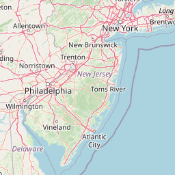
Map view of Jacques Cousteau National Estuarine Research Reserve

Use this park location map to pinpoint Jacques Cousteau National Estuarine Research Reserve in United States of America, understand its exact geographic position, and read its mapped placement within the surrounding landscape more clearly.

Pigeon | © OpenStreetMap contributors

Location context for Jacques Cousteau National Estuarine Research Reserve

New Jersey
Park atlas

Compare regional protected areas and connected coastal landscapes

Explore Parks Near Jacques Cousteau National Estuarine Research Reserve

Browse other parks and protected areas near Jacques Cousteau National Estuarine Research Reserve to examine similar coastal ecosystems and wetland habitats. Extending your geographic comparison across surrounding regional reserves reveals broader patterns in northeastern estuarine conservation.
Watercolor painting of a light, abstract landscape featuring green fields, soft hills in the background, and touches of pink and yellow vegetation.
Protected landscapeNew York
About 97 km away#1 closest

North

Gateway National Recreation Area: A Mapped Guide to Coastal Protected Landscapes

Urban coastal geography and maritime heritage sites

Spanning from the western Rockaway Peninsula to the shores of New Jersey, Gateway National Recreation Area serves as a major ecological anchor. This protected landscape integrates rare maritime habitats, barrier beach systems, and decommissioned military installations into a singular geographic footprint. Use this atlas resource to understand the park's three primary units and their roles in maintaining the natural shoreline of the New York Harbor region.

Area
107.67 km²
Established
1972
IUCN
V
Visitors
8.7M annual
Nature reserveDelaware
About 110 km away#2 closest

Southwest

Delaware National Estuarine Research Reserve: Coastal Estuary and Wetland Protected Landscape

A paired nature reserve system in Delaware

Delaware National Estuarine Research Reserve preserves a significant coastal gradient across two distinct units in Kent County. From the freshwater wetlands and forests of Blackbird Creek to the tidal salt marshes of the St. Jones River, this protected area serves as a primary hub for estuarine research, monitoring aquatic conditions, and safeguarding biodiversity within the Delaware Bay ecological corridor.

Established
1937
IUCN
IV
Relief
Lowland
Climate
Temperate
Protected landscapeNew York
About 149 km away#3 closest

Northeast

Fire Island National Seashore: Geography and Protected Area Exploration

Barrier island ecosystems and coastal wilderness in New York

Fire Island National Seashore spans a narrow, thirty-mile barrier island corridor, protecting a mosaic of maritime pine forest, expansive Atlantic beaches, and quiet bay-side salt marshes. This protected landscape includes the Otis Pike Fire Island High Dune Wilderness and the maritime holly canopy of the Sunken Forest, offering an essential reference for exploring coastal geography in New York.

Area
79.23 km²
Established
1964
IUCN
V
Visitors
393.7K annual
A minimalist watercolor painting depicting a soft green and pastel landscape with rolling hills and a central pond or marshy area on a white background.
Protected landscapeMaryland
About 155 km away#4 closest

Southwest

Assateague Island National Seashore: Geographic Atlas and Protected Landscape Overview

Dynamic barrier island terrain in the Maryland region

Assateague Island National Seashore preserves one of the most naturally functioning barrier island ecosystems in the Mid-Atlantic. This protected stretch of coastline showcases the interaction between sediment movement, storm-driven overwash, and salt marsh development, offering a clear view of how barrier systems respond to environmental forces.

Area
167.2 km²
Established
1965
IUCN
V
Visitors
2.3M annual
Watercolor illustration depicting a cascading waterfall nestled between rolling green hills and a gentle body of water.
Protected landscapeUnited States of America
About 162 km away#5 closest

North

Delaware Water Gap National Recreation Area: Regional Geography and Mapped Protected Landscapes

Appalachian river corridors and mountain pass geography.

Delaware Water Gap National Recreation Area serves as a major protected unit in the United States, centered on the dramatic geological pass where the Delaware River cuts through Kittatinny Mountain and Blue Mountain. This expansive landscape preserves critical riverine habitats, forested ridges, and historic corridors that provide a deep look into the regional geography of the mid-Atlantic Appalachians.

Area
270.09 km²
Established
1965
Visitors
4.2M annual
Relief
Mountain
A watercolor painting showing a soft, stylized view of rolling green hills, trees, and a river flowing through a valley.
Marine protected areaCharles County
About 282 km away#6 closest

Southwest

Mallows Bay, Potomac River National Marine Sanctuary: Mapping the Potomac River Ghost Fleet

A historic marine protected area in Charles County, Maryland.

The Mallows Bay, Potomac River National Marine Sanctuary preserves a significant maritime archaeology site within the Chesapeake Bay watershed. The protected area features the Ghost Fleet of World War I era steamships that have been reclaimed by river ecology. This region offers a distinct look at the intersection of cultural history and tidal freshwater habitats in Southern Maryland.

Area
47 km²
Established
2019
IUCN
V
Relief
Lowland
Nature reserveVirginia
About 317 km away#7 closest

Southwest

Chesapeake Bay National Estuarine Research Reserve, Virginia: Coastal and Estuarine Atlas

Mapped protected landscapes of the York River estuary.

Spanning the critical salinity gradient of the York River, this nature reserve integrates diverse tidal habitats including expansive marshes, quiet creeks, and coastal islands. As a center for scientific monitoring, the reserve offers a layered view of Mid-Atlantic estuarine geography, protecting essential buffers and water channels that define the lower Chesapeake Bay region.

Established
1991
Relief
Lowland
Climate
Temperate
Access
Access unknown
Marine protected areaRhode Island
About 337 km away#8 closest

Northeast

Narragansett Bay National Estuarine Research Reserve: Island and Marine Protected Area Overview

A coastal research landscape in Rhode Island

Discover the geographic composition of the Narragansett Bay National Estuarine Research Reserve. This marine protected area spans the terrestrial and aquatic zones of three major islands within the Narragansett Bay system, providing a deep look at estuarine habitat conservation and regional island geography.

Area
15.9 km²
Established
1980
Relief
Lowland
Climate
Temperate

Common questions about visiting, size, designation, and location context for Jacques Cousteau National Estuarine Research Reserve

Jacques Cousteau National Estuarine Research Reserve FAQs for park facts, access, geography, and protected area context

Find quick answers about Jacques Cousteau National Estuarine Research Reserve, including protected-area facts, park geography, trail and visitor context, and how the park fits into its surrounding country and regional landscape.
MoriAtlas Explorer

Continue Your Protected Areas Search Across the Global Atlas

Deepen your exploration by continuing the structured search for national parks and protected areas worldwide. Utilize the comprehensive filtering capabilities to compare different conservation landscapes and refine your understanding of global park geography. Discover more about the distribution and characteristics of protected natural areas.

Global natural geography