

Mori Atlas logo
National parkCrocker Range National Park

Understand the mapped boundaries and regional setting of this significant national park.

Crocker Range National Park: Malaysia's Protected Landscape and Geographic Context

(Taman Negara Banjaran Crocker)

Crocker Range National Park stands as a distinct national park within Malaysia, offering critical insights into the protected landscapes of the Borneo region. This atlas-focused entry provides a clear view of its geographic scope and mapped boundaries, situating it within the broader context of Southeast Asian conservation areas. Explore how this protected land contributes to the natural geography of Malaysia, serving as a vital point for landscape discovery and regional understanding.

mountain forestsprimatesBorneo biodiversitymontane ecosystemswatershed protectionendemic species

Crocker Range National Park

National park

Park overview

Structured park overview, official facts, and landscape profile for Crocker Range National Park

Crocker Range National Park park facts, protected area profile, and essential visitor context
Review the core facts for Crocker Range National Park, including designation, size, terrain, visitor scale, habitats, and operating context in one park-focused overview.

About Crocker Range National Park

Crocker Range National Park occupies a significant position in Sabah's protected area network as the largest park in the state. The park encompasses the Crocker Range, a north-south mountain system running along the western interior of Borneo. This mountainous landscape rises from lower hill forests at its base to montane forest zones at higher elevations, creating diverse ecological zones within a single protected area. The park's establishment in 1984 built upon earlier protection as a forest reserve, formalizing conservation of this critical mountain ecosystem. Beyond its ecological significance, the Crocker Range functions as an essential water catchment, with forest cover playing a vital role in maintaining clean water supplies for numerous towns and communities throughout Sabah. The park headquarters area features visitor facilities including a resort with accommodation and dining services, an exhibition centre explaining park resources, specialized botanical collections at the fernarium, and an insectarium showcasing invertebrate diversity. Visitors can also access an observation tower for panoramic views and a network of trekking trails exploring different sections of the mountain environment.

Quick facts and research context for Crocker Range National Park

Crocker Range National Park occupies 1,399 square kilometers in western Sabah, making it the largest park in the Malaysian state. The park protects the north-south Crocker Range, a mountain system with peaks reaching 1,800 meters. Established in 1984, the area had previously been protected as a forest reserve. The park lies between the towns of Beaufort and Tenom, with the Padas River bisecting the range. Visitor facilities at park headquarters include accommodation, dining, an exhibition centre, insectarium, fernarium, observation tower, and established trekking trails.

Park context

Deeper park guide and search-rich context for Crocker Range National Park

Crocker Range National Park history, landscape, wildlife, and travel context
Explore Crocker Range National Park through its history, landscape character, ecosystems, wildlife, conservation priorities, cultural context, and seasonal travel timing in a structured park guide built for atlas discovery and search intent.

Why Crocker Range National Park stands out

Crocker Range National Park is best known for its extensive montane forest ecosystems along the Crocker Range, which harbor remarkable biodiversity including at least five primate species. The park protects significant populations of orang-utans, gibbons, and the distinctive tarsier with its enormous round eyes, alongside highly social long-tailed macaques. As Borneo's largest park in Sabah, it serves as a critical watershed for regional water security while preserving habitats for species found nowhere else on Earth.

Crocker Range National Park history and protected-area timeline

Crocker Range National Park was formally established in 1984, though the area had previously existed under protection as a forest reserve. This transition from forest reserve to national park status reflected growing recognition of the mountain range's ecological significance and its importance to Sabah's environmental integrity. The establishment of the park created the largest protected area in Sabah, consolidating conservation protection across the north-south Crocker Range. Administration was assigned to Sabah Parks, the state agency responsible for managing Sabah's national parks and protected areas. Over time, visitor infrastructure has developed at the park headquarters, including the resort, exhibition centre, and specialized facilities like the insectarium and fernarium that help visitors understand the park's natural values.

Crocker Range National Park landscape and geographic character

The Crocker Range forms a prominent north-south mountain system in western Sabah, with elevations ranging from approximately 1,200 to 1,800 meters above sea level. This mountainous terrain creates dramatic topography within the park, with steep slopes, ridges, and valleys characteristic of the range. The landscape transitions from lower hill forest zones through increasingly stunted montane forest as elevation increases. The Padas River bisects the range between the towns of Beaufort and Tenom, cutting through the mountain landscape to create additional terrain variation. The mountain range forms a physical divide between the west coast lowlands and the interior of Sabah, with the park protecting the higher elevations and forested slopes that characterize this boundary. Dense forest cover dominates the landscape across all elevation zones, with the vegetation creating a continuous green backdrop throughout the park.

Crocker Range National Park ecosystems, habitats, and plant life

The forests of Crocker Range National Park support exceptional ecological diversity across both hill and montane forest types. These ecosystems contain numerous plant and animal species that are endemic to Borneo, meaning they are found nowhere else on Earth. The montane forest environment at higher elevations features distinct vegetation communities adapted to cooler, cloudier conditions. The forest cover throughout the park plays a critical ecological function as a watershed, with the Crocker Range catching and filtering moisture that feeds streams and rivers serving communities throughout Sabah. Maintaining this forest cover is essential for ensuring reliable, clean water supplies for the state's human population. The park's extensive area and elevation range create multiple habitat zones that support the rich biodiversity for which the region is renowned.

Crocker Range National Park wildlife and species highlights

Crocker Range National Park harbors remarkable wildlife diversity, with at least five primate species documented within its boundaries. The park provides habitat for orang-utans, the iconic great apes of Borneo, along with various gibbon species. The park is also known for the tarsier, a small nocturnal primate distinguished by its enormous round eyes adapted for night-time hunting. Highly social long-tailed macaques are common throughout the park. This primate diversity alone demonstrates the park's significance as a wildlife habitat. Beyond primates, the forest ecosystems support countless other species across mammals, birds, reptiles, amphibians, and invertebrates. The endemic nature of many species found here reflects Borneo island's role as a biodiversity hotspot.

Crocker Range National Park conservation status and protection priorities

Crocker Range National Park represents a critical conservation priority as the largest protected area in Sabah. The park protects the Crocker Range mountain ecosystem, which serves as a vital watershed providing water to communities throughout the state. Protecting the forest cover on these slopes is essential for maintaining water quality and regulating flows to downstream towns. The park's ecosystems harbor numerous endemic species, making conservation of this area important for global biodiversity preservation. The designation as a national park, following earlier protection as a forest reserve, reflects institutional recognition of these conservation values. Management by Sabah Parks ensures ongoing protection and sustainable use of the park's natural resources.

Crocker Range National Park cultural meaning and human context

While the primary focus of Crocker Range National Park is natural conservation, the mountain landscape holds significance for local communities in Sabah. The forest environment has historically provided resources and ecosystem services to indigenous communities in the region. The park lies within the traditional lands of various communities who have long maintained relationships with this mountain landscape. Water flowing from the Crocker Range supports communities in the surrounding lowlands, linking the park to regional livelihoods and well-being. The park's location between Beaufort and Tenom places it within a region of cultural significance for Sabah's diverse ethnic communities.

Top sights and standout views in Crocker Range National Park

The Crocker Range protects Borneo island's most extensive montane forest ecosystem within Sabah, with elevations reaching 1,800 meters. The park supports at least five primate species, including orang-utans, gibbons, tarsiers, and macaques. As Sabah's largest national park at 1,399 square kilometers, it serves as a critical watershed for the state. Visitor facilities include a resort, exhibition centre, insectarium, fernarium, observation tower, and trekking trails. The Padas River bisects the range between Beaufort and Tenom.

Best time to visit Crocker Range National Park

The park can be visited year-round, though the drier months typically offer more comfortable conditions for outdoor exploration and trekking. The mountain environment experiences high humidity and frequent cloud cover, particularly at higher elevations. Visitors planning treks and outdoor activities should consider seasonal weather patterns when planning their visit.
Park location guide

Geography guide, regional context, and park location map for Crocker Range National Park

Crocker Range National Park park geography, regions, and map view in Malaysia
Understand where Crocker Range National Park sits in Malaysia through a broader geographic reading of the surrounding landscape, nearby location context, and its mapped position within the national park landscape.

How Crocker Range National Park fits into Malaysia

Malaysia is a federal constitutional monarchy located in Southeast Asia. The country consists of 13 states and three federal territories, divided by the South China Sea into Peninsular Malaysia on the Indochinese Peninsula and East Malaysia on the island of Borneo. With a population of over 34 million, it achieved independence from Britain in 1957 and became a modern federation in 1963. The country is recognized for its multicultural population, tropical climate, and significant economic role in the region.

Wider geography shaping Crocker Range National Park in Malaysia

Malaysia occupies a strategic position in Southeast Asia, split by the South China Sea into two distinct regions. Peninsular Malaysia lies on the Indochinese Peninsula, sharing a land border with Thailand to the north and maritime borders with Singapore, Vietnam, and Indonesia. East Malaysia occupies the northern portion of Borneo, sharing land borders with Brunei and Indonesia, and maritime borders with the Philippines and Vietnam. The country's terrain includes coastal plains, mountain ranges such as the Titiwangsa in the peninsula, and extensive tropical rainforests.

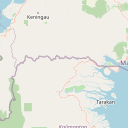
Map view of Crocker Range National Park

Use this park location map to pinpoint Crocker Range National Park in Malaysia, understand its exact geographic position, and read its mapped placement within the surrounding landscape more clearly.

Pigeon | © OpenStreetMap contributors

Location context for Crocker Range National Park

Sabah
Park atlas

Compare protected landscapes and trace regional park geography across the surrounding Sabah highlands.

Find Related National Parks and Protected Areas Near Crocker Range National Park in Sabah
Browse a curated list of other national parks and protected areas geographically close to Crocker Range National Park, tracing the interconnected montane forest ecosystems. Compare diverse protected landscapes within the region, mapping their unique conservation focus and geographic spread for deeper atlas exploration.
National parkSabah

Tunku Abdul Rahman National Park: Sabah National Park Protected Landscape & Geography

Explore mapped boundaries and regional context.

Tunku Abdul Rahman National Park, designated as a national park, offers a specific focus on protected landscape exploration within Sabah. This entity details its geographic footprint and its significance as a mapped natural area. Understanding its role within the regional geography allows for a more complete exploration of Malaysia's protected lands through an atlas perspective.

Area
49 km²
Established
1974
IUCN
II
Relief
Mixed relief
Nature reserveTemburong District

Peradayan Forest Reserve Nature Reserve: Understanding its Protected Landscape and Geographic Setting

Explore mapped boundaries and the natural terrain of this Brunei reserve.

Peradayan Forest Reserve stands as a significant protected natural area within Brunei's Temburong District, an exclave characterized by vast tropical rainforests. This entry focuses on its identity as a nature reserve, providing key geographic context and details about its mapped boundaries. Understand its role within the regional landscape and how its protected status contributes to the conservation of Brunei's natural heritage, facilitating a deeper dive into atlas-style geographic exploration.

Area
26.5 km²
Relief
Upland
Climate
Tropical
Access
Moderate access
Protected areaBrunei-Muara District

Bukit Shahbandar Forest Recreation Park: Protected Area with Ridge Landscape & Hiking Trails

Explore Brunei's unique recreational forest terrain and mapped natural features.

Bukit Shahbandar Forest Recreation Park is a notable protected area within the Brunei-Muara District, distinguished by its prominent grassy ridge and a network of challenging hiking trails that traverse its varied terrain. The park's landscape is characterized by rolling hills, including peaks that reach nearly 470 feet, offering strategic vantage points. As a recreational forest, it provides a distinct example of protected land use, blending modified natural vegetation with opportunities for outdoor activity and geographic discovery. Its unique topography and trail system offer a clear focus for atlas-based exploration.

Area
2.34 km²
Established
1998
IUCN
II
Visitors
35.5K annual
National parkBrunei

Ulu Temburong National Park: Brunei's Protected Rainforest Landscape and Geographic Context

Mapped natural terrain and conservation significance.

Ulu Temburong National Park represents Brunei's commitment to preserving its most ecologically significant tropical rainforests, covering approximately 550 square kilometers. This protected area is characterized by its remote location in the Temburong District and its diverse topography, ranging from lowland areas to mountainous ridges, all within a largely undisturbed natural setting. The park's mapped boundaries encompass a vital transboundary conservation landscape, making it a key site for understanding Borneo's unique ecosystems and forest protection policies through an atlas-driven exploration approach.

Area
488.59 km²
Established
1991
IUCN
II
Relief
Mixed relief
Protected areaBrunei

Tasek Merimbun Heritage Park: Protected Landscape Identity and Geographic Atlas

Mapped boundaries and regional natural context for this Brunei protected area.

Tasek Merimbun Heritage Park represents a distinct protected area within the geography of Brunei. This page provides detailed insight into its protected landscape, offering a map-centric view of its boundaries and its placement within the broader natural context of Borneo. Understand the park's geographic significance and explore its unique attributes for structured atlas exploration.

Area
78 km²
Established
1984
Climate
Tropical
Access
Easy access
National parkSarawak

Gunung Buda National Park: Sarawak National Park Protected Landscape and Geography

Explore the mapped boundaries and regional context of this Malaysian national park.

Gunung Buda National Park is a significant protected area within Sarawak, Malaysia, contributing to the region's diverse geography. As a national park, it offers specific insights into mapped protected lands, providing a focal point for understanding Borneo's natural landscapes. This entry details its geographic identity and its role as a protected natural space, crucial for any atlas-driven exploration of East Malaysia's conservation areas.

Area
66.2 km²
Established
2001
IUCN
II
Relief
Mountain
Nature reserveBrunei

Luagan Lalak Forest Recreation Park Nature Reserve: Brunei's Pristine Freshwater Swamp Landscape

Explore mapped protected-area geography and unique wetland terrain.

Luagan Lalak Forest Recreation Park, a protected nature reserve in Brunei, preserves a rare and visually distinctive freshwater swamp ecosystem. Characterized by dark, tranquil waters and vast fields of purun grass, this natural wetland offers a unique landscape context and is a prime location for observing its rich biodiversity, especially its notable birdlife. The park's preservation as an intact swamp environment within a recreational area highlights its ecological importance for regional geography and protected-area mapping.

Area
2.7 km²
Established
1980
IUCN
II
Visitors
4.2K annual
National parkMarudi District

Gunung Mulu National Park: A Protected National Park with Distinct Geographic Identity in Marudi District

Explore its mapped protected area and regional landscape.

Gunung Mulu National Park stands as a key protected area within Marudi District, Malaysia, offering critical insights into the region's natural geography. This national park entity provides a focal point for understanding mapped protected landscapes and their specific geographic characteristics. Users can explore the park's boundaries and its role within the wider atlas of Malaysian natural areas, gaining a solid foundation in its conservation geography.

Area
528.64 km²
Established
1974
IUCN
II
Relief
Mountain

Common questions about visiting, size, designation, and location context for Crocker Range National Park

Crocker Range National Park FAQs for park facts, access, geography, and protected area context
Find quick answers about Crocker Range National Park, including protected-area facts, park geography, trail and visitor context, and how the park fits into its surrounding country and regional landscape.
MoriAtlas Explorer

Continue Your Protected Areas Search Across the Global Atlas

Deepen your exploration by continuing the structured search for national parks and protected areas worldwide. Utilize the comprehensive filtering capabilities to compare different conservation landscapes and refine your understanding of global park geography. Discover more about the distribution and characteristics of protected natural areas.

Global natural geography
