Mori Atlas logo
Wildlife reserveDrigh Lake

Examine the geography of this Ramsar-listed freshwater habitat in the Indus floodplain

Drigh Lake Wildlife Reserve: Mapping the Protected Wetland Landscapes of Sindh, Pakistan

(Drigh Lake Wildlife Sanctuary)

Drigh Lake represents a vital freshwater wetland sanctuary situated in the rural Indus plains of Sindh, Pakistan. As an internationally recognized Ramsar site, this reserve provides a crucial habitat for waterbirds along migratory flyways. This analysis traces the park boundaries, its elongated freshwater profile, and the surrounding agricultural geography that defines this unique protected landscape within the provincial context of Sindh.

wetlandfreshwater lakeRamsar sitewildlife sanctuarybirdwatchingmigratory birds

Drigh Lake

Wildlife reserve

Park overview

Structured park overview, official facts, and landscape profile for Drigh Lake

Drigh Lake park facts, protected area profile, and essential visitor context

Review the core facts for Drigh Lake, including designation, size, terrain, visitor scale, habitats, and operating context in one park-focused overview.

About Drigh Lake

Drigh Lake sits in the open agricultural landscape of upper Sindh, within the Qambar Shahdadkot District. The lake is a relatively compact freshwater body, around 164 hectares in extent and stretching roughly four miles from north to south. Its setting among the flat Indus floodplain lands defines much of its visual and ecological character, with shallow margins, fringing vegetation, and open water that together create productive habitat for waterbirds.

The lake's ecological value was formally recognised in two stages. In 1972, the area was notified as a wildlife sanctuary, giving it domestic legal protection. Four years later, in July 1976, Drigh Lake was designated under the Ramsar Convention as a Wetland of International Importance, becoming one of the early Pakistani sites to receive this status. The Ramsar listing reflects the lake's importance for migratory waterbirds and its role in supporting internationally recognised habitat types.

For visitors and naturalists, Drigh Lake functions primarily as a birdwatching and conservation site rather than a destination for dramatic scenery. The lake's principal interest lies in the density and variety of waterbirds that use it through the year, particularly during the winter season when migratory species arrive from northern breeding grounds. Herons, egrets, ducks, kingfishers, coots, and several raptors are among the most regularly recorded groups, giving the lake a strong reputation among birders familiar with Sindh's wetlands.

Beyond its birdlife, Drigh Lake illustrates the wider importance of smaller inland wetlands in Pakistan's conservation landscape. Together with other Ramsar sites in Sindh and southern Punjab, it forms part of a network of refuge habitats that sustain migratory bird populations across the Indus basin and beyond, contributing to the ecological coherence of the region.

Quick facts and research context for Drigh Lake

Drigh Lake is a freshwater lake and wildlife sanctuary in the Qambar Shahdadkot District of Sindh, Pakistan. It was declared a wildlife sanctuary in 1972 and designated a Ramsar Wetland of International Importance in July 1976, with Ramsar site reference number 100. The lake covers roughly 164 hectares and extends about four miles from north to south, hosting a wide variety of resident and winter migratory birds.

Protection and recognition

Documented terrestrial protection scope and Ramsar site recognition records

Drigh Lake Protection Status and Official International Recognition Data

Drigh Lake maintains a documented terrestrial protection scope backed by official Ramsar site recognition records. Systematic conservation data outlines the established governance framework, international source matches, and administrative designation history.

International recognition

Protection details

Protection scope
Terrestrial
Park context

Deeper park guide and search-rich context for Drigh Lake

Drigh Lake history, landscape, wildlife, and travel context

Explore Drigh Lake through its history, landscape character, ecosystems, wildlife, conservation priorities, cultural context, and seasonal travel timing in a structured park guide built for atlas discovery and search intent.

Why Drigh Lake stands out

Drigh Lake is best known as a bird-rich Ramsar wetland in rural Sindh. Its shallow freshwater environment draws a mix of resident and winter migratory species, including herons, egrets, ducks, and several birds of prey, making it a recognised site along regional waterbird migration routes.
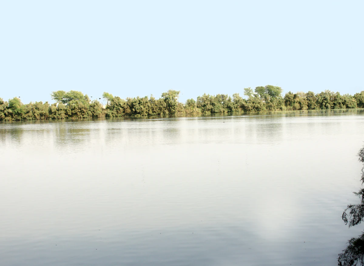
A wide, calm expanse of water fills most of the frame, with a line of low trees and vegetation bordering the far bank under a pale, bright sky.
A view of the waters of Drigh Lake, a protected wildlife sanctuary in Sindh, Pakistan.

Drigh Lake history and protected-area timeline

The area now known as Drigh Lake was first placed under formal protection in 1972, when it was declared a wildlife sanctuary under Pakistani law. This step reflected growing awareness of the lake's ecological value, particularly as habitat for resident and migratory waterbirds in the Sindh region.

In 1976, the lake's conservation significance was elevated further when it was designated a Wetland of International Importance under the Ramsar Convention, with Ramsar site reference number 100. The 1976 designation was one of the earlier international recognitions for a Pakistani wetland, putting Drigh Lake alongside a small group of sites in the country identified for their global importance to waterbird populations. The combined status of wildlife sanctuary and Ramsar site has continued to shape the lake's management and conservation profile ever since.

Drigh Lake landscape and geographic character

Drigh Lake occupies a stretch of the flat Indus floodplain in upper Sindh, where the surrounding terrain is shaped by agriculture and the slow hydrology of the broader river basin. The lake itself is a shallow, low-lying freshwater body that runs roughly four miles from north to south, giving it an elongated open-water profile.

Its margins are fringed by wetland vegetation typical of Sindh's inland lakes, including reeds, sedges, and patches of emergent plants that break up the shoreline and create transitional habitat between open water and dry land. The wider landscape around the lake is largely cultivated, with fields and villages punctuating the otherwise open plains. This combination of open water, vegetated fringe, and agricultural surroundings gives Drigh Lake much of its visual identity and contributes to its value as waterbird habitat.

Unlike dramatic mountain or coastal landscapes, Drigh Lake's character is defined by subtlety: the interplay of shallow water, soft shoreline vegetation, and expansive sky over the plains of Sindh.

Drigh Lake ecosystems, habitats, and plant life

The ecological identity of Drigh Lake is centred on its wetland habitats. The lake is a freshwater system whose shallow waters and vegetated margins support a rich mix of aquatic, semi-aquatic, and shoreline plant communities typical of Sindh's inland wetlands.

These habitat zones provide feeding, resting, and breeding conditions for waterbirds throughout much of the year. The open water itself supports dabbling and diving ducks, while the reed-fringed edges offer cover for herons, coots, and swamphens. Raptors using the lake depend on the same mosaic of habitats, hunting over the open water and adjacent fields.

The lake's Ramsar status reflects the broader ecological significance of these habitats, situating Drigh Lake within international frameworks for the conservation of wetlands and the migratory species that rely on them.

Drigh Lake wildlife and species highlights

Drigh Lake is particularly noted for its birdlife, which is the dominant feature of the site's wildlife interest. Both resident and winter migratory species are well represented, giving the lake a varied and seasonally dynamic avian character.

Herons and egrets are among the most conspicuous groups, with night heron, grey heron, purple heron, great white egret, and little egret all associated with the site. Ducks form another major component of the bird checklist, including mallard, gadwall, northern pintail, common teal, garganey, tufted duck, ferruginous duck, common pochard, and the globally notable marbled teal. Wading and waterside species such as purple gallinule, white-breasted waterhen, moorhen, and coot add further diversity.

Birds of prey are also a regular feature of the lake, with osprey, marsh harrier, pied harrier, and the greater spotted eagle recorded in the area. Kingfishers, including the white-breasted, pied, and small blue kingfisher, contribute to the shoreline birdlife along with cormorant and darter. Together these species confirm Drigh Lake's standing as an important inland waterbird site within Sindh.

Drigh Lake conservation status and protection priorities

Drigh Lake's conservation significance is rooted in its dual designation as a wildlife sanctuary and a Ramsar Wetland of International Importance. The wildlife sanctuary status, granted in 1972, gives the lake domestic legal protection, while the 1976 Ramsar listing places it within an international network of wetlands recognised for their ecological value.

Beyond its formal designations, the lake plays a meaningful role in supporting migratory waterbird populations that travel along Central Asian and South Asian flyways. Its freshwater habitats and associated reedbeds provide stopover and wintering habitat for a wide range of species, contributing to the broader conservation of waterbirds that depend on a network of wetlands across Pakistan.

The lake's protected status also reflects the wider importance of smaller inland wetlands in Sindh, where habitat loss and hydrological change have placed increasing pressure on natural waterbodies. By maintaining habitat for vulnerable and migratory species under formal protection, Drigh Lake functions as a conservation anchor in the regional wetland landscape.

Drigh Lake cultural meaning and human context

Drigh Lake is embedded in a rural agricultural part of Sindh, where small settlements and farming communities have long coexisted with the wetland landscape. The lake forms part of the everyday geographical setting of nearby towns such as Qambar and larger centres such as Larkana, contributing to the local sense of place and to the relationship between people and water in the upper Indus plains.

While the lake is primarily known for its natural and conservation values, its cultural setting in an agricultural region with deep historical roots in Sindh gives it an additional layer of local significance, connecting it to the broader heritage of the Indus basin.

Top sights and standout views in Drigh Lake

Drigh Lake stands out as one of Sindh's recognised Ramsar wetlands, combining domestic sanctuary status with international conservation recognition. Its elongated, shallow freshwater profile and reed-fringed margins create ideal conditions for waterbirds, supporting an unusually rich checklist that includes herons, egrets, multiple duck species, kingfishers, and several raptors.

The lake's significance is reinforced by its early role in Pakistan's engagement with the Ramsar Convention and by its ongoing function as habitat for migratory species. For anyone interested in Sindh's inland wetlands, Drigh Lake offers a compact yet representative example of how a small lake can carry meaningful national and international conservation weight.

Best time to visit Drigh Lake

Drigh Lake's birdlife varies through the year, with both resident species and winter visitors contributing to its character. The winter months are generally associated with peak presence of migratory waterfowl, when ducks, raptors, and other seasonal species join the resident herons, egrets, and kingfishers around the lake. Outside the winter influx, the lake continues to host a wide range of resident species, making it a working birdwatching site across much of the year.

Seasonal water levels and agricultural activity in the surrounding landscape can also influence the experience of visiting the lake, with different times of year offering different mixes of species and varying visibility across the open water and reed margins.
Monthly climate preview

Track multi-year temperature ranges and monthly precipitation averages across representative coordinates in Sindh

Drigh Lake Climate Normals and Long Term Temperature Patterns

Historical data records long-term temperature swings and low precipitation rates across representative coordinates in Sindh, charting recorded monthly maximums, minimums, and averages from 1991 to 2020. Examining the complete twelve-month climatology profile provides deeper analytical insight into annual meteorological rhythms and multi-year environmental baselines.
Annual mean29 °C
16 °C39 °C
Jan16°
Feb19°
Mar26°
Apr32°
May37°
Jun39°
Jul38°
Aug37°
Sep34°
Oct30°
Nov23°
Dec18°
Warmest month
June

39.2 °C

Coolest month
January

16.1 °C

Wettest month
August

0.8 mm/day

Driest month
October

0.1 mm/day

Park location guide

Geography guide, regional context, and park location map for Drigh Lake

Drigh Lake park geography, regions, and map view in Pakistan

Understand where Drigh Lake sits in Pakistan through a broader geographic reading of the surrounding landscape, nearby location context, and its mapped position within the national park landscape.

How Drigh Lake fits into Pakistan

Pakistan, officially the Islamic Republic of Pakistan, is a federal parliamentary Islamic republic in South Asia. It is the fifth-most populous country and the 33rd-largest by area. The country gained independence from British India in 1947 and has a diverse history spanning ancient civilizations including Mehrgarh and the Indus Valley Civilisation. Pakistan shares maritime borders with Oman and is bounded by the Arabian Sea, Gulf of Oman, and several neighboring countries.

Wider geography shaping Drigh Lake in Pakistan

Pakistan is located in South Asia, bordered by the Arabian Sea to the south, the Gulf of Oman to the southwest, and shares land borders with India to the east, Afghanistan to the west, Iran to the southwest, and China to the northeast. The country also shares a maritime border with Oman in the Gulf of Oman. The Wakhan Corridor in Afghanistan separates Pakistan from Tajikistan in the northwest.

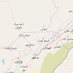
Map view of Drigh Lake

Use this park location map to pinpoint Drigh Lake in Pakistan, understand its exact geographic position, and read its mapped placement within the surrounding landscape more clearly.

Pigeon | © OpenStreetMap contributors

Location context for Drigh Lake

Sindh

Explore photographic records of open freshwater terrain, reed margins, and sanctuary environments.

Drigh Lake Photos and Landscape Scenery: Visualizing Protected Wetland Habitats

Visual documentation captures the shallow freshwater body, soft shoreline vegetation, and expansive skies defining the protected Indus floodplain. Photographic records reveal the wetland characteristics and aquatic habitats supporting regional waterbird populations across the sanctuary.

A wide, calm expanse of water fills most of the frame, with a line of low trees and vegetation bordering the far bank under a pale, bright sky.

Park atlas

Compare regional wildlife sanctuaries and freshwater wetland habitats across the Indus basin.

Explore Protected Areas and Wetlands Near Drigh Lake

Browse nearby national parks and protected landscapes to compare regional wetland ecosystems and bird sanctuaries. Extending the search beyond Drigh Lake reveals connected conservation networks across the surrounding river basin.
Wildlife reserveKhairpur District
About 73 km away#1 closest

East

Mehrano Wildlife Sanctuary: Protected Forest Landscapes and Geography in Khairpur District

A historic wildlife reserve along the Indus riverine corridor.

Mehrano Wildlife Sanctuary represents a unique intersection of private historical stewardship and modern conservation. This riverine forest in Khairpur District provides a critical habitat for large game and migratory bird populations, functioning as a lush ecological refuge at the edge of the Cholistan desert. The terrain offers a distinct study in Indus floodplain geography and long-standing protected land management.

Area
2.8 km²
Established
1790
Relief
Lowland
Scope
Terrestrial
Wildlife reserveSindh
About 91 km away#2 closest

Southeast

Deh Akro-II Desert Wetland Complex: Protected Landscape and Geographic Mapping

Inland wetland and desert sanctuary in Sindh, Pakistan

Explore the distinctive geography of Deh Akro-II Desert Wetland Complex, a protected wildlife reserve defined by its unusual combination of sand dunes and freshwater lakes. This atlas entry details the natural terrain and ecological boundaries of one of Pakistan's most significant inland wetland systems, illustrating the complex intersection of arid and aquatic habitats within the Indus River system.

Area
205 km²
Established
1988
Relief
Lowland
Climate
Arid
Nature reserveSindh
About 166 km away#3 closest

South

Pai Forest Nature Reserve: Geography and Protected Landscape Context in Sindh

An Indus floodplain reserve featuring arid and riverine flora

Pai Forest in Sindh offers a distinctive study of protected landscapes where canal irrigation sustains both riverine and arid plant communities. This reserve functions as a vital ecological island amidst agricultural plains, providing a rich case for exploring the interaction between water management and natural terrain within the Indus valley geography.

Relief
Lowland
Climate
Arid
Scope
Terrestrial
Water
Major water bodies
National parkPakistan
About 210 km away#4 closest

South

Kirthar National Park: Discover Pakistan's Arid Mountain Protected Landscape

Explore the mapped geography and unique terrain of this vital national park.

Kirthar National Park represents a critical expanse of protected semi-arid mountainous terrain in southern Pakistan, covering over 3,000 square kilometers. It is recognized for its significant populations of Sindh ibex, urial, and chinkara gazelles, alongside a diverse array of raptors, including migratory vulture and eagle species. The park's unique landscape, characterized by parallel ridges and deep, dry valleys, provides crucial habitat in a region facing considerable development pressures, offering a distinct geographical context for protected area exploration.

Area
3,087 km²
Established
1974
IUCN
II
Relief
Mountain
National parkBalochistan
About 259 km away#5 closest

Southwest

Hingol National Park: Pakistan's Unique Protected Landscape and Geological Atlas

Discover dramatic rock formations and coastal geography.

Hingol National Park stands as a monumental protected landscape within Balochistan, Pakistan, offering an unparalleled atlas view of geological diversity. Renowned for its hoodoos like the Princess of Hope and the Balochistan Sphinx, the park also features active mud volcanoes and striking coastal semi-desert terrain. The confluence of the Hingol River with the Arabian Sea creates important wetland habitats. This national park provides a rich context for exploring unique natural formations and regional geography, making it a significant point of discovery within Pakistan's protected areas.

Area
6,100 km²
Established
1988
IUCN
II
Relief
Mixed relief
Protected areaBalochistan
About 284 km away#6 closest

Southwest

Miani Hor Protected Area: Coastal Lagoon Mapping and Regional Geography in Balochistan

Coastal lagoon and unique mangrove wetland ecosystem

Miani Hor functions as a major tidal lagoon and protected wetland along the Balochistan coast. The area is defined by its extensive mangrove forests and connection to the Arabian Sea, providing a essential study in estuarine geography and wetland conservation within the Lasbela District.

Area
74.71 km²
Established
2001
Relief
Lowland
Scope
Mixed
Watercolor painting of a calm lake with grassy foreground, small islands, and distant hills under a soft light.
Wildlife reserveSindh
About 290 km away#7 closest

South

Keenjhar Lake Wildlife Reserve: Sindh Province Protected Wetland and Geographic Atlas

Mapped freshwater wetland and regional wildlife sanctuary

Keenjhar Lake is a prominent freshwater wetland and wildlife reserve in the Thatta District of Sindh. This expansive basin serves as a key ecological anchor for migratory waterbirds and a central feature of the regional landscape. The area combines significant hydrological value with distinct cultural history, providing a unique look into the protected geography of southeastern Pakistan.

Area
134.68 km²
Relief
Lowland
Scope
Terrestrial
Water
Water-dominated
A wide watercolor painting showing a body of water in the foreground, green trees and shrubs in the middle ground, and rolling hills in the background under a pale sky.
Protected areaThatta District
About 306 km away#8 closest

South

Haleji Lake Protected Area: Mapping Wetlands and Freshwater Ecosystems in Thatta District

A significant freshwater reservoir and Ramsar site in southern Sindh, Pakistan.

Situated in the low-lying plains of Thatta District, Haleji Lake functions as an essential freshwater sanctuary for migratory bird species. The site features a distinct mosaic of managed reservoirs, fringing marshes, and brackish lagoons, offering a unique look at the interaction between water engineering and natural wetland conservation in the Indus basin.

Area
6.58 km²
Established
1943
Relief
Lowland
Scope
Terrestrial

Common questions about visiting, size, designation, and location context for Drigh Lake

Drigh Lake FAQs for park facts, access, geography, and protected area context

Find quick answers about Drigh Lake, including protected-area facts, park geography, trail and visitor context, and how the park fits into its surrounding country and regional landscape.
MoriAtlas Explorer

Continue Your Protected Areas Search Across the Global Atlas

Deepen your exploration by continuing the structured search for national parks and protected areas worldwide. Utilize the comprehensive filtering capabilities to compare different conservation landscapes and refine your understanding of global park geography. Discover more about the distribution and characteristics of protected natural areas.

Global natural geography