Mori Atlas logo
Nature reserveEllergronn

Tracing the geological evolution of collapse ponds and post industrial woodland terrain

Ellergronn Nature Reserve: Mapping the Industrial and Natural Landscapes of Southern Luxembourg

(Naturschutzgebitt Ellergronn)

Ellergronn Nature Reserve represents a distinctive intersection of post industrial heritage and ecological regeneration in southern Luxembourg. This protected area features a unique terrain shaped by mining subsidence, where former ironstone galleries have collapsed to form deep ponds amidst a mosaic of woodland and dry grassland. Users can examine the geography of this site to understand how historical quarrying and ironstone extraction have matured into a protected landscape, creating a varied habitat that stands as a notable example of geological transformation within the Minett region.

nature reservepost-industrial landscapeironstone miningformer quarrywoodlandcollapse ponds

Ellergronn

Nature reserve

Park overview

Structured park overview, official facts, and landscape profile for Ellergronn Nature Reserve

Ellergronn Nature Reserve park facts, protected area profile, and essential visitor context

Review the core facts for Ellergronn Nature Reserve, including designation, size, terrain, visitor scale, habitats, and operating context in one park-focused overview.

About Ellergronn Nature Reserve

Ellergronn is a compact nature reserve whose character is inseparable from the mining history of Luxembourg's Minett region. The southern part of the country was long defined by the extraction of iron-bearing Dogger-age sedimentary rocks, the so-called Minett ironstone, and the wealth generated by this industry shaped Esch-sur-Alzette and surrounding towns.

Where much of the region's ore was quarried in open pits, at Ellergronn the ironstone was worked underground in galleries and shafts belonging to the Cockerill mining complex. Over time many of those galleries collapsed. The resulting surface subsidence produced a chain of crater-like depressions which filled with rainwater, creating the ponds that now sit at the heart of the reserve. The largest of these is the Liégeois-Weier, more than ten metres deep, with several smaller pools scattered through the surrounding woodland.

Above the ironstone layers lie extensive limestone beds that were also extracted within the reserve, near the French border, in an old quarry. The cut stone was moved on small rail lines toward storage works and the cement plant at Esch, while spoil and overburden piled up beside the old track eventually matured into a patch of dry grassland, now a distinctive habitat within the protected zone.

The reserve as a whole was placed under formal protection in March 1988 and covers around 110 hectares. In 1991, the forestry administration, working together with the city of Esch-sur-Alzette, laid out a roughly three-kilometre nature trail starting from the Ellergronn visitor centre. Fifteen interpretive stations along the loop explain the area's geology, mining history, and present-day ecology, positioning Ellergronn as both a natural refuge and an open-air record of Luxembourg's industrial heritage.

Quick facts and research context for Ellergronn Nature Reserve

Ellergronn lies in the commune of Esch-sur-Alzette in southern Luxembourg, close to the French border and the former Cockerill ironstone mines. The protected area covers about 110 hectares of forest, ponds, and former industrial ground, and has been officially protected since 19 March 1988. It is classified as a Zone of National Interest under Luxembourg's nature conservation framework. The reserve sits on Dogger-age iron-bearing sediments typical of the Minett mining region and also includes exposures of limestone that was quarried near the border.

Protection and recognition

Terrestrial conservation scope and official designation records

Ellergronn Protection Status and Documented Conservation Framework

Ellergronn maintains a documented terrestrial protection scope within its registered regional boundary. Structured conservation records outline the established management framework and official designation history for this protected area.

Protection details

Protection scope
Terrestrial
Park context

Deeper park guide and search-rich context for Ellergronn Nature Reserve

Ellergronn Nature Reserve history, landscape, wildlife, and travel context

Explore Ellergronn Nature Reserve through its history, landscape character, ecosystems, wildlife, conservation priorities, cultural context, and seasonal travel timing in a structured park guide built for atlas discovery and search intent.

Why Ellergronn Nature Reserve stands out

Ellergronn is best known for the way its industrial past has been absorbed back into nature. Underground ironstone galleries of the former Mines Cockerill gradually collapsed, letting the surface sink into funnel-shaped hollows that filled with water and became the reserve's ponds, the largest being the Liégeois-Weier. A former limestone quarry waste heap has, in turn, matured into a patch of dry grassland, giving the reserve an unusual blend of woodland, open water, and semi-open calcareous habitats on a small footprint.
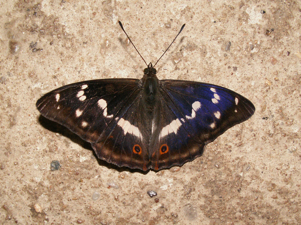
A top down view of a Purple Emperor butterfly with dark blue iridescent wings and white markings resting on a textured, light colored stone surface.
A Purple Emperor butterfly seen in the Ellergronn nature reserve.

Ellergronn Nature Reserve history and protected-area timeline

The landscape that is now Ellergronn Nature Reserve was shaped by two overlapping phases of mineral extraction tied to the industrial rise of southern Luxembourg. The underlying ironstone, known as Minett ore, was deposited in a Jurassic-era sea roughly 160 to 180 million years ago and later lithified into the sedimentary layers that gave the Minett region its name and economic importance.

In the Ellergronn area the ironstone was not extracted from open pits, as was common elsewhere in the region, but was won underground in galleries and shafts belonging to the Cockerill mining operation, situated directly beside the French border south of Esch-sur-Alzette. Many of those old galleries have since subsided, and the gradual sinking of the surface above them produced the characteristic collapse craters, some of which filled with water to form the reserve's ponds.

On top of the iron-bearing layers, a substantial limestone formation was quarried for stone in a separate pit close to the border. The cut stone was hauled by small rail-borne wagons (buggies) to storage yards and onward to the cement works at Esch. Material cleared from the quarry was tipped beside the old track, and over time that deposit developed into a tract of dry grassland that is now part of the protected site.

The area itself received formal nature protection status on 19 March 1988, recognizing roughly 110 hectares as a Zone of National Interest. A nature trail was established in 1991 by the forestry administration in cooperation with the town of Esch-sur-Alzette, and fifteen interpretive panels were installed to explain the site's intertwined natural and industrial story to visitors.

Ellergronn Nature Reserve landscape and geographic character

Ellergronn's terrain is a small-scale palimpsest of geological and industrial activity. The reserve sits on Jurassic-age ironstone sediments, but its modern surface is shaped less by natural erosion than by the slow aftermath of underground mining and quarrying.

The most distinctive landforms are the collapse craters. Where the galleries of the former Cockerill mines have caved in, the ground has subsided into rounded, almost funnel-like depressions, several of which now hold permanent water. The biggest of these, the Liégeois-Weier, reaches depths of more than ten metres and sits as a dark, still pool within the surrounding woodland; smaller ponds repeat the same pattern at lower depths through the forest.

Alongside these watery hollows, the reserve carries the traces of old limestone quarrying near the French border. Excavation left a worked face of calcareous rock, while a neighbouring spoil mound, originally laid down as waste beside a narrow-gauge track, has matured into a piece of dry grassland where thin soils and lime-rich substrate define a very different habitat from the woodland around it.

Woodland still dominates the wider reserve, linking the ponds, the dry grassland, and the quarry edge into a single mosaic; the roughly three-kilometre nature trail is designed to pass through all of these zones in turn.
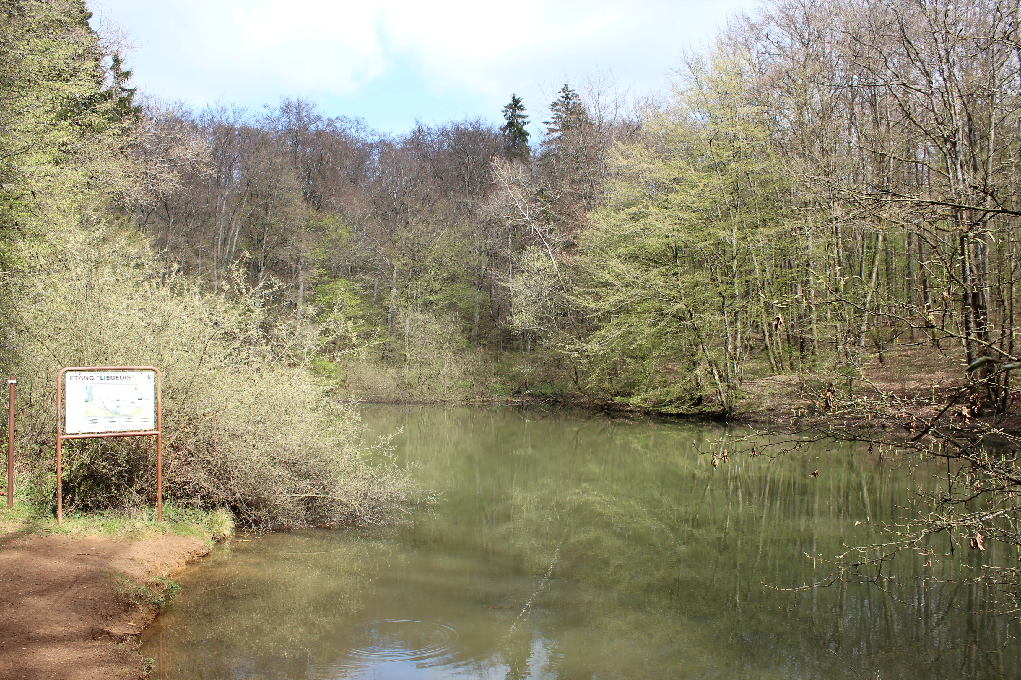
A calm, still pond surrounded by dense forest in the Ellergronn Nature Reserve, with an information sign visible on the left bank.
The Liegeois Pond within the Ellergronn Nature Reserve, reflecting the surrounding forest.

Ellergronn Nature Reserve ecosystems, habitats, and plant life

The habitat mosaic of Ellergronn is unusually concentrated given its size, because industrial disturbance has produced a mixture of conditions that would normally be spread across a much larger area. The dominant cover is deciduous forest, growing on the ironstone-derived soils above the old Minett layers. Under the canopy, dead wood, leaf litter, and sheltered microclimates support a rich forest-floor fauna and a range of invertebrates.

The most striking habitats, however, are the open ones. The collapse ponds and their fringing vegetation behave as small wetland patches embedded in woodland, while the old limestone quarry face and the adjacent dry-grassland mound together create open, calcareous conditions. This contrast between shaded wet hollows and bright, thin-soil dry grassland gives Ellergronn a diverse ecological profile in a compact footprint.

The 1991 nature trail with its fifteen stations was explicitly designed to expose these transitions, walking visitors from pond edges into forest and out again across drier, more open ground, so that the ecological story of the reserve can be read directly from the landscape.

Ellergronn Nature Reserve wildlife and species highlights

Among the protected species recorded at Ellergronn, the large or purple emperor butterfly (Apatura iris) is one of the most notable. It is a woodland-dependent butterfly associated with mature deciduous forest and willow stands near water, a habitat profile that matches the reserve's pond-fringed woodland.

The slow worm (Anguis fragilis), a legless lizard rather than a snake, is also listed among the reserve's protected fauna. Its presence is a good indicator of the kind of warm, sheltered, structurally varied ground cover found along woodland edges, grassland margins, and old quarry workings.

Beyond these named species, the reserve's combination of ponds, forest, and dry grassland provides habitat for a broader community of amphibians, invertebrates, and small woodland vertebrates associated with the mix of wet and dry conditions created by the former mining landscape.

Ellergronn Nature Reserve conservation status and protection priorities

Ellergronn was placed under formal protection on 19 March 1988 and is classified as a Zone of National Interest within Luxembourg's nature conservation system. This designation covers roughly 110 hectares of forest, ponds, and former industrial land in the commune of Esch-sur-Alzette.

Its conservation value lies particularly in the combination of habitats that mining has accidentally renewed. Quarrying and underground ironstone extraction created collapse pools and calcareous dry grassland that now sit alongside mature deciduous woodland, supporting protected species such as the purple emperor butterfly and the slow worm in close proximity.

The reserve is actively managed in cooperation with the city of Esch-sur-Alzette. The 1991 educational trail, with fifteen interpretive panels along a three-kilometre loop, anchors both the conservation message and the public engagement around the site, and the visitor centre at the start of the trail serves as the main point of contact for orientation and information.

Ellergronn Nature Reserve cultural meaning and human context

Ellergronn sits within the Minett region of southern Luxembourg, whose identity was built over more than a century around the extraction and processing of Minett ironstone. For generations this steel-and-mining belt shaped the economy, demography, and urban culture of towns like Esch-sur-Alzette. The Cockerill mining complex beside the reserve was a key part of that industrial heritage.

Because much of the surrounding extractive industry has wound down, the reserve also carries a strong post-industrial memory. Local signage and trail panels frame the site not only as a natural refuge but as a landscape that has been read and reinterpreted after the mines, turning former workings into a shared place of nature, geological education, and regional memory.

Top sights and standout views in Ellergronn Nature Reserve

The Liégeois-Weier pond, more than ten metres deep and lying within collapse terrain from the former Cockerill mines, is the reserve's single most distinctive feature and the centrepiece of its nature trail. The mosaic of woodland, collapse pools, and calcareous dry grassland on a site of roughly 110 hectares gives Ellergronn an unusually compressed ecological variety, supported by protected species such as the purple emperor butterfly and the slow worm. The 1991 three-kilometre educational loop, with fifteen interpretive stations and a dedicated visitor centre, ties the natural and industrial stories of the Minett region into a single easy walking experience.

Best time to visit Ellergronn Nature Reserve

Spring and early summer are well suited to appreciating Ellergronn's mix of habitats, when woodland ground flora is at its richest and conditions around the ponds and dry grassland are most biologically active; these months also coincide with the flight period of woodland butterflies such as the purple emperor, a species of particular interest at the site. Late spring through summer likewise showcases the dry grassland areas in their most herbaceous and insect-rich state. Visits in any mild season benefit from the reserve's compact three-kilometre trail network, which reliably shows the contrast between shaded forest and open former-quarry ground.

Monthly climate preview

Track monthly average temperatures and precipitation patterns across the protected landscape

Ellergronn Climate Normals, Long-Term Temperature and Precipitation Rhythm

Ellergronn records structured long-term climate normals spanning mean monthly temperatures from near freezing to warm summer maximums alongside steady daily precipitation rates. Examining the full twelve-month profile reveals detailed baseline trends for average temperature and monthly precipitation across the coordinate.
Annual mean9 °C
0 °C19 °C
Jan
Feb
Mar
Apr
May13°
Jun17°
Jul19°
Aug19°
Sep14°
Oct
Nov
Dec
Warmest month
July

19.1 °C

Coolest month
January

0.4 °C

Wettest month
December

2.7 mm/day

Driest month
April

1.6 mm/day

Park location guide

Geography guide, regional context, and park location map for Ellergronn Nature Reserve

Ellergronn Nature Reserve park geography, regions, and map view in Luxembourg

Understand where Ellergronn Nature Reserve sits in Luxembourg through a broader geographic reading of the surrounding landscape, nearby location context, and its mapped position within the national park landscape.

How Ellergronn Nature Reserve fits into Luxembourg

Luxembourg is a small landlocked nation in Western Europe and the world's only grand duchy. It borders Belgium, Germany, and France, with Luxembourg City as its capital and largest city. The country has one of the highest GDP per capita figures globally and hosts several EU institutions, notably the Court of Justice. Its population of nearly 700,000 is multinational, with Luxembourgish as the national language and French and German as administrative languages.

Wider geography shaping Ellergronn Nature Reserve in Luxembourg

Luxembourg is located in Western Europe, landlocked between Belgium to the west and north, Germany to the east, and France to the south. The terrain consists largely of forested uplands and plains in the Oesling region to the north, with the Gutland region in the south featuring more fertile land. The country covers 2,586 square kilometres, making it Europe's seventh-smallest nation.

Map view of Ellergronn Nature Reserve

Use this park location map to pinpoint Ellergronn Nature Reserve in Luxembourg, understand its exact geographic position, and read its mapped placement within the surrounding landscape more clearly.

Pigeon | © OpenStreetMap contributors

Explore detailed photographic records of woodland habitats, collapse ponds, and reclaimed post-industrial terrain.

Ellergronn Landscapes and Scenery: Visualizing Protected Area Terrain

Visual records capture the distinctive topography of Ellergronn through detailed imagery of collapse ponds, woodland tracks, and calcareous grasslands. Examining these protected area views reveals how post-industrial mining landscapes have transitioned into complex ecological habitats.

A top down view of a Purple Emperor butterfly with dark blue iridescent wings and white markings resting on a textured, light colored stone surface.

A brown, legless Eurasian slow worm (Anguis fragilis) captured from above, positioned in an S-shape on a rough, stony gravel path.

A calm, still pond surrounded by dense forest in the Ellergronn Nature Reserve, with an information sign visible on the left bank.

Park atlas

Compare regional park geography and adjacent protected landscapes

Explore Parks Near Ellergronn and Protected Areas Across the Surrounding Region

Visitors exploring Ellergronn can discover adjacent protected areas and regional nature reserves within the surrounding mining landscape. Comparing nearby park geography helps reveal broader patterns of ecological recovery and woodland conservation across southern Luxembourg.
Watercolor painting of a green, rolling landscape with scattered trees and soft hills against a light background.
Nature reserveLuxembourg
About 3.5 km away#1 closest

Northeast

Brucherbierg-Lallengerbierg Nature Reserve: Industrial Heritage and Protected Geography in Luxembourg

A restored Minett mining landscape and thriving dry-grassland ecosystem.

Brucherbierg-Lallengerbierg offers a window into the evolution of post-industrial terrain. Spanning 267 hectares in southern Luxembourg, the reserve protects a rugged landscape of cliffs, stony basins, and terraces that have been reclaimed by pioneer vegetation. Through careful ecological maintenance, the site serves as a prime example of habitat conservation, preserving a rare, open dry-meadow environment within the broader Minett industrial corridor.

Area
2.67 km²
Established
2016
Relief
Upland
Water
Minor water
A horizontal watercolor painting showing a quiet wetland with light green vegetation, a shallow pool of water reflecting soft purples, and gentle hills in the background on a white background.
Nature reserveSchifflange
About 4.8 km away#2 closest

Northeast

Brill Nature Reserve: Wetland Geography and River Restoration in Schifflange

Exploring the protected Alzette River floodplain and riparian habitat mosaic

Brill Nature Reserve stands as an ecologically significant protected area within the heavily developed valley of Schifflange, Luxembourg. This wetland sanctuary showcases a successful river restoration project, creating a dense network of ponds, reedbeds, and river-delta woodlands that function as a crucial refuge for wildlife amidst urban surroundings.

Area
0.197 km²
Established
1988
Relief
Lowland
Scope
Terrestrial
A minimalist watercolor illustration featuring rolling green hills, patches of trees, and a soft, light-toned foreground against a white background.
Nature reserveLuxembourg
About 6.3 km away#3 closest

East

Naturschutzgebitt Haard: Exploring Luxembourg's Largest Reclaimed Nature Reserve

Geography of a transformed iron-mining industrial landscape

Naturschutzgebitt Haard encompasses vast quarry faces and pioneer meadows, serving as a critical biodiversity hub within southern Luxembourg. The area offers an intricate landscape mosaic of calcareous grassland, recovering forest, and dramatic mining cliffs, providing a window into how post-industrial ground evolves into a protected refuge for specialized orchid and butterfly species.

Area
5.943 km²
Established
1994
Relief
Upland
Climate
Temperate
Nature reserveLuxembourg
About 11 km away#4 closest

East

Naturschutzgebitt Däerebësch-Waal-Hellengerbësch: Protected Forest and Transboundary Geography

Nature reserve profile and regional landscape connectivity

Spanning 222 hectares across Bettembourg, Dudelange, and Frisange, this nature reserve preserves a contiguous forest landscape essential to the Natura 2000 network. The site is defined by its role as a cross-border ecological corridor, connecting Luxembourgish woodlands with the Forêt domaniale de Zoufftgen in France through a sophisticated wildlife bridge.

Area
2.223 km²
Established
2023
Relief
Upland
Climate
Temperate
Nature reserveLuxembourg
About 11 km away#5 closest

Northeast

Beetebuerger Bësch: Nature Reserve and Protected Woodland Mapping in Luxembourg

A crucial reference site for forest ecology in southern Luxembourg

Beetebuerger Bësch stands as a designated nature reserve within the communes of Bettembourg, Leudelange, and Roeser. This protected forest landscape is managed to allow natural woodland development, providing researchers and visitors with a view of old growth dynamics, saproxylic invertebrate habitats, and restored riparian zones along the Koleschgriecht stream.

Area
2.373 km²
Established
2005
Relief
Lowland
Climate
Temperate
Watercolor illustration of a landscape with rolling hills, a river, and green vegetation
Protected areaProvince of Luxembourg
About 17 km away#6 closest

Northwest

Gaume Natural Park: A Protected Area Defining the Landscape of Province of Luxembourg

Explore its mapped natural landscape and geographic context.

Gaume Natural Park is a protected area offering a unique perspective on the natural landscapes found within Belgium's Province of Luxembourg. As a key geographic entity, it provides a vital component for atlas exploration, showcasing distinct mapped boundaries and regional terrain. Understand its significance as a protected natural space contributing to the Ardennes region's extensive geography, making it an essential point for structured discovery of protected lands.

Area
581.04 km²
Established
2014
IUCN
V
Relief
Lowland
A horizontal watercolor painting depicting a gentle river flowing through a soft green landscape with trees and distant rolling hills.
Nature reserveLuxembourg
About 25 km away#7 closest

Northeast

Naturschutzgebitt Birelergronn Nature Reserve: Luxembourg Protected Valley Geography

A sandstone valley landscape in central Luxembourg.

Naturschutzgebitt Birelergronn encompasses a 270 hectare nature reserve in Luxembourg, recognized for its complex hydrological features and historic milling valley structure. The area highlights the geological significance of the Luxembourg Sandstone, supporting diverse alluvial forests and the expansive Neimillen wetland complex which defines the regional ecosystem.

Area
2.717 km²
Established
1999
Relief
Upland
Climate
Temperate
A horizontal watercolor painting of a wetland scene with still water, grassy banks, small islands, and rolling hills in the background.
Nature reserveSchengen
About 27 km away#8 closest

East

Haff Réimech Nature Reserve: Wetland Geography and Protected Landscape in Schengen

Reclaimed industrial wetlands in the Moselle river valley

Haff Réimech is a protected wetland sanctuary located in the Moselle valley near Schengen. The reserve features approximately forty shallow lakes created from former sand and gravel pits, now surrounded by reedbeds and riparian woodland. This mosaic landscape serves as a key site for migratory bird species, demonstrating a unique transition from industrial extraction to a managed, ecologically rich floodplain environment.

Area
1.008 km²
Established
1998
Relief
Lowland
Climate
Temperate

Common questions about visiting, size, designation, and location context for Ellergronn Nature Reserve

Ellergronn Nature Reserve FAQs for park facts, access, geography, and protected area context

Find quick answers about Ellergronn Nature Reserve, including protected-area facts, park geography, trail and visitor context, and how the park fits into its surrounding country and regional landscape.
MoriAtlas Explorer

Continue Your Protected Areas Search Across the Global Atlas

Deepen your exploration by continuing the structured search for national parks and protected areas worldwide. Utilize the comprehensive filtering capabilities to compare different conservation landscapes and refine your understanding of global park geography. Discover more about the distribution and characteristics of protected natural areas.

Global natural geography