
Mori Atlas logo
Protected areaFelchowseegebiet

Tracing the protected forest and aquatic boundaries of this Uckermark conservation site

Felchowseegebiet: A Mapped Protected Landscape of Glacial Lakes and Forests in Brandenburg

(Naturschutzgebiet Felchowseegebiet)

Felchowseegebiet sits within the Uckermark district of Brandenburg as a significant protected area defined by its glacial lakes and extensive forest cover. This territory features a network of interconnected water bodies including the Felchowsee, Großer Stebensee, and Wustrowsee, which serve as core habitats for local amphibians. The landscape allows for the study of near-natural forest succession and woodland development, providing a clear window into the ecological character of northeastern Germany.

nature reserveBrandenburgUckermarkglacial lakeslake landscapeprotected forest
A flat-design illustration showing a lush valley surrounded by steep cliffs and mountains, with a river flowing through the center and a waterfall in the distance.

Felchowseegebiet

Protected area

Park overview

Structured park overview, official facts, and landscape profile for Felchowseegebiet

Felchowseegebiet park facts, protected area profile, and essential visitor context

Review the core facts for Felchowseegebiet, including designation, size, terrain, visitor scale, habitats, and operating context in one park-focused overview.

About Felchowseegebiet

Felchowseegebiet is a compact but ecologically significant nature reserve in the Uckermark, the lake-rich and historically forested region of northeastern Brandenburg. Although it is not a national park, it functions as a formal Naturschutzgebiet, the German designation for a strictly regulated nature protection area, and it carries an official state identifier and an entry in the World Database on Protected Areas, where it is recognized under IUCN Category IV as a Habitat/Species Management Area.

The reserve's defining feature is a cluster of four lakes embedded in a forested setting. The largest is the Felchowsee, which extends across roughly 140 hectares, while the Großer Stebensee, Kleiner Stebensee, and the small Wustrowsee add smaller water surfaces and tighter shoreline habitats. Around these lakes lie woodland stands, transitional wetland zones, and small streams whose character has been shaped by the post-glacial landscape of the Uckermark. The presence of multiple water bodies in close proximity gives the reserve a mosaic pattern of aquatic and terrestrial habitats that is well suited to species that depend on both forest cover and clean, quiet water.

Much of the land is owned by the NABU-Stiftung Nationales Naturerbe, a German conservation foundation focused on preserving meaningful natural landscapes. On the foundation's forested holdings, the goal is to allow the woodland to develop largely without intervention, so that natural forest structures and old-growth characteristics can emerge over time. Along the smaller water bodies, the foundation places particular emphasis on protecting amphibians, since the combination of shaded woodland edges and small, sheltered waters in the Uckermark is highly favorable to a range of native amphibian species.

Landschaftlich liegt das Schutzgebiet etwa zehn Kilometer östlich des Städtchens Angermünde und damit im Kernbereich der Uckermark, einer Region, die für ihre seenreiche Glaziallandschaft und ihre ausgedehnten Wälder bekannt ist. Die Lage östlich des Dorfes Pinnow ist verkehrlich gut erschlossen, weil die Bundesstraße 2 westlich und nördlich des Gebiets verläuft und die Landesstraße 284 es im Süden begrenzt. Trotz dieser Nähe zu Straßen bleibt das Schutzgebiet selbst ein ruhiger, wald- und wassergeprägter Raum, der seine Schutzfunktion über die Jahrhunderte weiterhin erfüllen kann.

Taken together, Felchowseegebiet represents a typical but well-protected example of the lake and forest landscapes characteristic of the Uckermark. Its blend of glacial lakes, continuous woodland, and conservation-led management makes it a meaningful node within the wider protected-area network of Brandenburg.

Quick facts and research context for Felchowseegebiet

Felchowseegebiet is a nature reserve (Naturschutzgebiet) located in the Landkreis Uckermark in the state of Brandenburg, Germany, east of the village of Pinnow. It was placed under protection by a Brandenburg state regulation dated 23 December 2002, with the formal establishment recorded on 3 June 2003, and it carries the official protected-area identifier 1055.

The reserve spans roughly 972 hectares and centers on a cluster of glacial lakes: the Felchowsee (around 140 hectares), the Großer Stebensee, the Kleiner Stebensee, and the Wustrowsee (about 7.15 hectares). About 403 hectares of the area are owned by the NABU-Stiftung Nationales Naturerbe, which manages the woodland for the development of natural forest and supports amphibian protection around the smaller water bodies.

Protection and recognition

Documented terrestrial designation history, management scope, and Natura 2000 records

Felchowseegebiet Protection Status and International Recognition Data

Felchowseegebiet maintains a documented terrestrial protection status established in 2002 alongside official Natura 2000 recognition sources. Review structured designation history and international conservation records compiled within the protected area database.

International recognition

Protection details

Protection scope
Terrestrial
Designated year
2002
Transboundary protection
No
WDPA ID
14407
Park context

Deeper park guide and search-rich context for Felchowseegebiet

Felchowseegebiet history, landscape, wildlife, and travel context

Explore Felchowseegebiet through its history, landscape character, ecosystems, wildlife, conservation priorities, cultural context, and seasonal travel timing in a structured park guide built for atlas discovery and search intent.

Why Felchowseegebiet stands out

Felchowseegebiet is best known for its combination of glacial lakes and surrounding forests in the northeastern Brandenburg landscape. The reserve's identity rests on the Felchowsee and the linked Stebenseen and Wustrowsee, which together create a network of quiet, ecologically valuable water bodies set within woodland. A defining aspect of the reserve is how much of its land is held and actively managed by a conservation foundation for the purpose of allowing natural old-growth forest to develop. This combination of lake-rich terrain and dedicated natural-forest management gives the site a distinctive profile among Brandenburg nature reserves.
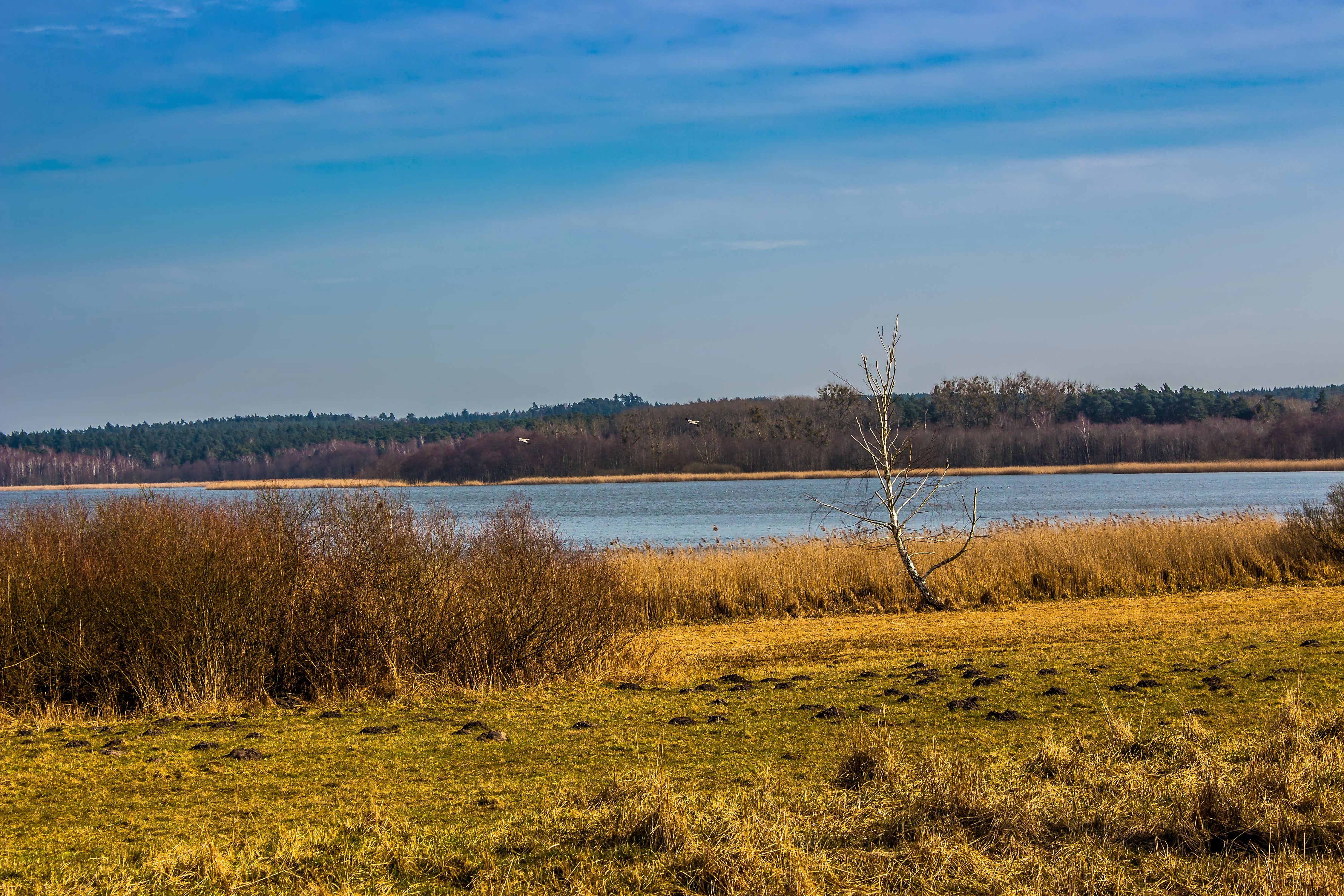
A calm lake viewed from a grassy, autumn-toned meadow, with a bare tree in the foreground and a line of dark forest trees along the horizon.
A scenic view of Felchowsee, the central lake within the Felchowseegebiet nature reserve.

Felchowseegebiet history and protected-area timeline

The Felchowseegebiet became a formally protected nature reserve through a regulation issued by the state of Brandenburg on 23 December 2002. The reserve was officially established on 3 June 2003, and it has since been registered under the official identifier 1055 in the Brandenburg protected-area system, as well as in international databases of protected areas.

Although the designation itself is relatively recent, the surrounding Uckermark landscape carries a much longer history shaped by glacial processes, traditional land use, and changing patterns of forestry and land ownership. The acquisition of substantial parts of the area by the NABU-Stiftung Nationales Naturerbe marked an important step in focusing the reserve on long-term natural-forest development and species protection rather than active timber management.

Since its designation, the reserve has continued to be managed as a Habitat/Species Management Area under IUCN Category IV, with particular attention to natural forest development on foundation-owned lands and to the conservation of amphibians around the smaller water bodies within the site.

Felchowseegebiet landscape and geographic character

The landscape of Felchowseegebiet is defined by a cluster of lakes set within a forested setting in the Uckermark region of northeastern Brandenburg. The lakes themselves, including the Felchowsee, the Großer Stebensee, the Kleiner Stebensee, and the Wustrowsee, trace their origins to the glacial history of the region and give the area its characteristic wave of quiet water surfaces interspersed with woodland.

The terrain around the lakes is gently undulating, shaped by the broader post-glacial morphology of the Uckermark. Forest stands lie close to the shorelines and in some places extend right down to the water, while small transitional zones of wetland and moist woodland connect the aquatic and terrestrial parts of the reserve. The matrix of wood and water produces a landscape that is both visually continuous and ecologically varied, with different shoreline exposures, sheltered bays, and shaded forest margins.

Felchowseegebiet ecosystems, habitats, and plant life

Ecologically, Felchowseegebiet is shaped by the interplay between forest and freshwater. The lake cluster, together with smaller associated waters, supports wetland-influenced habitats, while the surrounding woodland contributes mature and developing forest cover. The result is a habitat mosaic in which forest species, water-dependent species, and species that use transitional woodland-wetland edges can all find conditions suited to them.

IUCN lists the site as a Habitat/Species Management Area, signaling that the reserve is actively managed not just for general landscape protection but for the benefit of specific habitats and species. The forest portions of the reserve are increasingly left to develop under natural dynamics, which encourages the development of old-growth characteristics such as deadwood, structural diversity, and undisturbed microhabitats. Around the lakes and smaller water bodies, attention is directed toward the conditions that amphibians and other freshwater-dependent species require.

Felchowseegebiet wildlife and species highlights

Although the source material does not present an exhaustive species inventory, Felchowseegebiet's character strongly suggests the presence of forest-dwelling fauna and water-dependent species typical of the Uckermark lake landscape. The reserve's amphibian focus is explicitly mentioned, indicating that frogs, toads, and newts are among the key species groups of conservation interest at the site.

The combination of quiet lakes, sheltered bays, and forested shorelines also creates conditions favorable to a wide range of waterbirds and to forest-interior bird species, while the natural-forest approach on the foundation-owned land benefits species that depend on mature woodland structure over time. The reserve thus functions both as a freshwater wildlife refuge and as a site where forest wildlife can benefit from less intensive land management.

Felchowseegebiet conservation status and protection priorities

Felchowseegebiet is formally protected as a Naturschutzgebiet under Brandenburg law and is internationally recognized as an IUCN Category IV Habitat/Species Management Area. This dual status places the site within both national and international frameworks for habitat and species protection.

A defining conservation feature is the significant ownership share held by the NABU-Stiftung Nationales Naturerbe, which manages around 403 hectares of the reserve. On those lands, the foundation pursues a strategy that allows woodland to develop under natural forest dynamics, rather than under conventional forestry regimes. Around the smaller water bodies, conservation work focuses specifically on amphibian protection, recognizing the ecological importance of the reserve's smaller lakes and ponds for these species. Together, these efforts make Felchowseegebiet a working example of targeted habitat and species protection within Brandenburg's broader reserve system.

Felchowseegebiet cultural meaning and human context

While the source material does not document a deep layer of cultural or historical detail, the reserve sits within the Uckermark region, a historically forested and lake-rich part of Brandenburg with a long tradition of forestry, small-scale agriculture, and lake-based settlement. The village of Pinnow, just west of the protected area, reflects the typical rural settlement pattern of this corner of Brandenburg, where villages have long coexisted with extensive surrounding woodlands and water bodies.

Top sights and standout views in Felchowseegebiet

Felchowseegebiet's strongest distinctions are its tightly knit group of glacial lakes within a single protected area, the presence of substantial foundation-owned forest managed for natural development, and its explicit focus on amphibian conservation around smaller water bodies. Together these features give the reserve a clear identity as a lake-and-forest refuge in the Uckermark.

The reserve also stands out for its recognition at multiple levels, from a formal Brandenburg state designation to inclusion in the World Database on Protected Areas, signaling its place within the wider regional and international network of protected sites.

Best time to visit Felchowseegebiet

As a forested lake landscape in northeastern Brandenburg, Felchowseegebiet is shaped by the region's typical seasonal rhythm of mild summers and cooler, sometimes snowy winters. Late spring and early summer tend to bring active amphibian movement and lush forest vegetation, making this a particularly lively period for nature observation around the smaller water bodies. Autumn highlights the woodland character of the reserve, while winter offers a quieter atmosphere with potential ice cover on the lakes.

Monthly climate preview

Long term monthly temperature ranges and precipitation rhythm across representative coordinates

Felchowseegebiet Climate Normals, Average Temperature and Precipitation Profiles

Representative coordinate records show measured annual temperature variations and monthly precipitation patterns across Felchowseegebiet. Examining weather by month through complete climatological profiles reveals detailed long term averages for this Brandenburg protected area.
Annual mean9 °C
-1 °C20 °C
Jan-1°
Feb
Mar
Apr
May13°
Jun17°
Jul20°
Aug19°
Sep15°
Oct
Nov
Dec
Warmest month
July

19.8 °C

Coolest month
January

-1.2 °C

Wettest month
July

2.5 mm/day

Driest month
April

1.1 mm/day

Park location guide

Geography guide, regional context, and park location map for Felchowseegebiet

Felchowseegebiet park geography, regions, and map view in Germany

Understand where Felchowseegebiet sits in Germany through a broader geographic reading of the surrounding landscape, nearby location context, and its mapped position within the national park landscape.

How Felchowseegebiet fits into Germany

Germany is a federal republic in Western and Central Europe with a population of over 83 million across sixteen constituent states. It is Europe's largest economy by nominal GDP and a major global exporter and importer. The capital is Berlin, and the country borders Denmark, Poland, Czech Republic, Austria, Switzerland, France, Luxembourg, Belgium, and the Netherlands.

Wider geography shaping Felchowseegebiet in Germany

Germany is located in Western and Central Europe, spanning 357,022 km². It borders Denmark to the north, Poland and the Czech Republic to the east, Austria and Switzerland to the south, and France, Luxembourg, Belgium, and the Netherlands to the west. The country has coastlines on the Baltic Sea and North Sea to the north, with the Alps located in the southern region.

Map view of Felchowseegebiet

Use this park location map to pinpoint Felchowseegebiet in Germany, understand its exact geographic position, and read its mapped placement within the surrounding landscape more clearly.

Pigeon | © OpenStreetMap contributors

Location context for Felchowseegebiet

Brandenburg

Visual exploration of glacial lakes, shorelines, and old growth woodland habitats

Felchowseegebiet Landscape Photos, Glacial Lake Scenery, and Protected Forest Views

Visual documentation captures the interconnected glacial lakes and protected woodland terrain that define Felchowseegebiet in northeastern Germany. Photographic records reveal the natural forest development, wetland transitions, and quiet water environments of the Uckermark nature reserve.

A calm lake viewed from a grassy, autumn-toned meadow, with a bare tree in the foreground and a line of dark forest trees along the horizon.

Park atlas

Compare regional glacial lake reserves and forested conservation areas

Other Parks Near Felchowseegebiet and Related Protected Landscapes in Uckermark

Browse other protected areas near Felchowseegebiet to examine similar post glacial lake networks and woodland reserves across northeastern Germany. Continuing the comparison across the Uckermark region reveals broader patterns in regional park geography and protected landscape management.
Watercolor painting depicting a river flowing through a valley with green vegetation and distant mountains
National parkBrandenburg
1.2 km away#1 closest

East

Lower Oder Valley National Park: Unique Polder Landscape and Bird Sanctuary

Discover protected area maps and regional geography in Brandenburg

Delve into the Lower Oder Valley National Park, a national park recognized for its extraordinary polder landscape and extensive wetland ecosystems. This page provides detailed geographic context, highlighting the park's unique engineered floodplain, its role as a sanctuary for numerous bird species, and its position within the regional geography of Brandenburg. Understand the mapped boundaries and ecological importance of this exceptional protected area.

Area
103.23 km²
Established
1995
IUCN
II
Visitors
150K annual
Protected landscapeWest Pomeranian Voivodeship
6.1 km away#2 closest

South

Cedynia Landscape Park: Mapped Protected Landscapes and Regional Geography in Poland

Protected mosaic of sandy forests and river valleys

Spanning 308 square kilometers, Cedynia Landscape Park protects a complex transition zone in Poland. The area features the expansive Puszcza Piaskowa pine forests, the hilly moraine relief of the Cedynia Carpathians, and the biodiverse wetlands of the lower Oder River. This protected landscape represents an essential study in lowland ecological gradients and postglacial terrain development within the West Pomeranian Voivodeship.

Area
308.5 km²
Established
1993
Relief
Upland
Climate
Temperate
Protected landscapeWest Pomeranian Voivodeship
9.5 km away#3 closest

Southeast

Wzgórza Krzymowskie Protected Landscape: Moraine Geography and Map Context

Glacial ridges and forest landscapes in West Pomeranian Voivodeship

Wzgórza Krzymowskie serves as a primary example of compressed postglacial relief in northwestern Poland. The protected area features a unique combination of sandy inland dunes, internal moraine hills, and a steep western escarpment that carves deep ravines towards the Oder. This geographic analysis highlights the structural connection between the Puszcza Piaskowa forest, spring-fed stream networks, and elevated viewpoints across the regional landscape.

Relief
Upland
Access
Easy access
Scope
Terrestrial
Water
Major water bodies
Protected areaBrandenburg
19 km away#4 closest

Northwest

Suckower Haussee Protected Area: Geographic Overview and Habitat Mosaic in Uckermark, Brandenburg

Mapping spring mires, wet meadows, and dry grassland ecosystems

Suckower Haussee preserves a diverse habitat gradient typical of the Uckermark district. The protected area features a unique juxtaposition of limnic, peat-forming wetland habitats and nutrient-poor dry grasslands. This site acts as an essential component of the regional conservation network in northeastern Brandenburg, demonstrating the importance of small-scale landscape protection.

Area
1.37 km²
Established
1990
Scope
Terrestrial
Water
Major water bodies
A watercolor painting depicting a calm wetland landscape with thin, bare tree trunks rising from the water, backed by soft green rolling hills and lush vegetation.
Nature reserveBrandenburg
23 km away#5 closest

West

Arnimswalde Nature Reserve: Mapped Protected Lake and Forest Ecosystems in Brandenburg

Glacial landscape and Natura 2000 protected territory

Arnimswalde represents a significant protected nature reserve within the Brandenburg region of Germany. This detailed geographic profile covers the reserve's unique glacial lake basins, peat-stained dystrophic waters, and diverse forest communities, offering a structured view of its contribution to regional biodiversity and the broader Schorfheide-Chorin conservation framework.

Area
14.069 km²
Established
1990
IUCN
IV
A soft watercolor illustration of a lake landscape with calm water, a green tree-lined shore, and gently rolling hills in the background.
Nature reserveBrandenburg
24 km away#6 closest

West

Krinertseen Nature Reserve: Protected Glacial Lakes and Bog Landscapes in Brandenburg

Essential geographic data for the Uckermark wetland conservation area.

Krinertseen provides a concentrated view of Brandenburg's post-glacial terrain. This nature reserve serves as an ecologically significant area defined by mesotrophic-alkaline lakes and active lake-succession mires. The site acts as a key component of the wider Schorfheide-Chorin conservation network, showcasing the complex relationship between regional hydrology and protected forest ecosystems.

Area
3.51 km²
Established
1990
IUCN
IV
Relief
Lowland
Watercolor painting of a gentle green hilly landscape with a foreground of soft pink and purple tones, set against a light background.
Nature reserveLandkreis Uckermark
24 km away#7 closest

West

Endmoränenlandschaft bei Ringenwalde: Nature Reserve and Glacial Landscape Exploration

Geomorphology and protected forest geography in Landkreis Uckermark

This nature reserve stands as a textbook example of end moraine morphology shaped by Pleistocene glaciers. The area serves as a vital component of the broader Schorfheide-Chorin Biosphere Reserve, preserving a distinct system of forested ridges, basin lakes, and varied micro-relief that offers deep insight into the natural history of the Brandenburg region.

Area
5.69 km²
Established
1990
IUCN
IV
Nature reserveBrandenburg
24 km away#8 closest

South

Tongruben Neuenhagen Nature Reserve: Protected Wetland Geography in Brandenburg, Germany

Examining post-industrial clay-pit habitats and protected wetland boundaries

Tongruben Neuenhagen is a designated nature reserve located in Brandenburg, Germany, established to protect biological communities that have developed within former clay extraction pits. The area features a complex mosaic of open water, wetland margins, and transitional scrub habitats. This reserve provides a notable example of how historical industrial land use can be repurposed into valuable habitat for protected species, serving as a key element of the local conservation network in the Märkisch-Oderland region.

Area
1.196 km²
Established
1990
IUCN
IV
Relief
Lowland

Common questions about visiting, size, designation, and location context for Felchowseegebiet

Felchowseegebiet FAQs for park facts, access, geography, and protected area context

Find quick answers about Felchowseegebiet, including protected-area facts, park geography, trail and visitor context, and how the park fits into its surrounding country and regional landscape.
MoriAtlas Explorer

Continue Your Protected Areas Search Across the Global Atlas

Deepen your exploration by continuing the structured search for national parks and protected areas worldwide. Utilize the comprehensive filtering capabilities to compare different conservation landscapes and refine your understanding of global park geography. Discover more about the distribution and characteristics of protected natural areas.

Global natural geography