Mori Atlas logo
Protected landscapeWzgórza Krzymowskie

Understanding the glacial terrain, forested dunes, and valley escarpments within this northwestern Poland protected area

Wzgórza Krzymowskie: A Detailed Geographic Atlas of Moraine Hills and Protected Landscapes

Wzgórza Krzymowskie stands as a significant microregion of the Myślibórz Lake District, defined by complex postglacial relief and protected land status. This area features a striking contrast between interior moraine ridges, such as the Zwierzyniec summit, and the steep western escarpment dropping into the Lower Oder Valley. By examining the interplay of spring-fed ravines, inland dunes of the Puszcza Piaskowa forest, and fragmented slopes, the map-based structure reveals a landscape shaped by diverse Pleistocene processes.

moraine hillsglacial landscapePuszcza PiaskowaNatura 2000landscape parkLower Oder Valley

Wzgórza Krzymowskie

Protected landscape

Park overview

Structured park overview, official facts, and landscape profile for Wzgórza Krzymowskie

Wzgórza Krzymowskie park facts, protected area profile, and essential visitor context

Review the core facts for Wzgórza Krzymowskie, including designation, size, terrain, visitor scale, habitats, and operating context in one park-focused overview.

About Wzgórza Krzymowskie

Wzgórza Krzymowskie occupies a distinctive position in the geography of northwestern Poland as the northwestern sub-region of the Myślibórz Lake District and, more broadly, a recognizable piece of the South Baltic Lakelands. The hills form a compact ensemble of moraine ridges, kettle hollows, and outwash plains that were shaped during the Pleistocene glaciations and later reworked by wind and water. Their highest summit, Zwierzyniec, only modestly exceeds 160 meters, yet the relief relative to the neighboring lowlands is striking, especially along the western edge where the terrain drops to the floor of the Lower Oder Valley.

Land cover here is shaped by large forested tracts. The central and southeastern sections fall within Puszcza Piaskowa, a broad sandy-forest landscape whose mature woodlands and stabilized dunes give the region much of its ecological and aesthetic character. Around this forest core, a mosaic of agricultural land, meadows, small lakes such as Ostrów and Mętno, and spring-fed streams creates a varied landscape pattern typical of Polish lakeland-moraine transition zones.

A defining human-geographical feature of Wzgórza Krzymowskie is its overlap with two layers of formal protection. Most of the microregion is included in the Cedyński Landscape Park, while its central and southeastern parts also form the Wzgórza Krzymowskie Natura 2000 special area of conservation, designated for habitat protection under the European ecological network. This double designation reflects the ecological value of the moraine forests, springhead complexes, and dry-ground habitats concentrated here.

As a tourist landscape, the Wzgórza are integrated into a regional network of small historic towns. Cedynia, Moryń, and Chojna act as gateways, and observation towers, lookout points, the Dolina Miłości valley near Zatoń Dolna, and the memorial on Góra Czcibora related to the Battle of Cedynia add cultural depth. Together, the area combines glacial scenery, protected forest ecosystems, and lowland Polish heritage into a coherent geographic identity.

Quick facts and research context for Wzgórza Krzymowskie

Wzgórza Krzymowskie is a moraine hill microregion in the northwestern corner of the Myślibórz Lake District, within Gryfino County in the West Pomeranian Voivodeship of Poland. Its highest summit, Zwierzyniec, reaches around 167 meters above sea level, and the entire range marks the transition between the postglacial lake landscape to the east and the Lower Oder Valley to the west, where the hills descend in a steep escarpment.

Much of the area is protected through the Cedyński Landscape Park and a Natura 2000 special area of conservation bearing the same name. The hills are administered across the gminas of Cedynia, Chojna, and Moryń, and are crossed by several long-distance hiking and cycling trails, including sections of the Nadodrzański Trail and the Chojeńskie Lakes cycling route.

Protection and recognition

Examine the terrestrial conservation framework and official designation sources for Wzgórza Krzymowskie.

Wzgórza Krzymowskie Protection Status and Natura 2000 Recognition Details

Wzgórza Krzymowskie maintains documented terrestrial protection status supported by verified Natura 2000 recognition records. Review the official designation parameters and conservation frameworks associated with this protected landscape.

International recognition

Protection details

Protection scope
Terrestrial
Transboundary protection
No
Park context

Deeper park guide and search-rich context for Wzgórza Krzymowskie

Wzgórza Krzymowskie history, landscape, wildlife, and travel context

Explore Wzgórza Krzymowskie through its history, landscape character, ecosystems, wildlife, conservation priorities, cultural context, and seasonal travel timing in a structured park guide built for atlas discovery and search intent.

Why Wzgórza Krzymowskie stands out

Wzgórza Krzymowskie is best known for its scenic moraine landscape where glacial hills, deeply cut stream valleys, spring complexes, and forested dunes converge above the Oder river lowland. The hills are particularly associated with the Puszcza Piaskowa, a large sandy-forest complex that dominates their central and western portions, and with panoramic viewpoints overlooking the Lower Oder Valley. The microregion is also recognized for the unusual density of viewpoints found here for a lowland area in Poland. Numerous elevated points, observation towers in Cedynia and on Zwierzyniec, and the terrace view from the Mariacki Church tower in Chojna together make the Wzgórza a reference landscape for viewing glacially shaped terrain in West Pomerania.
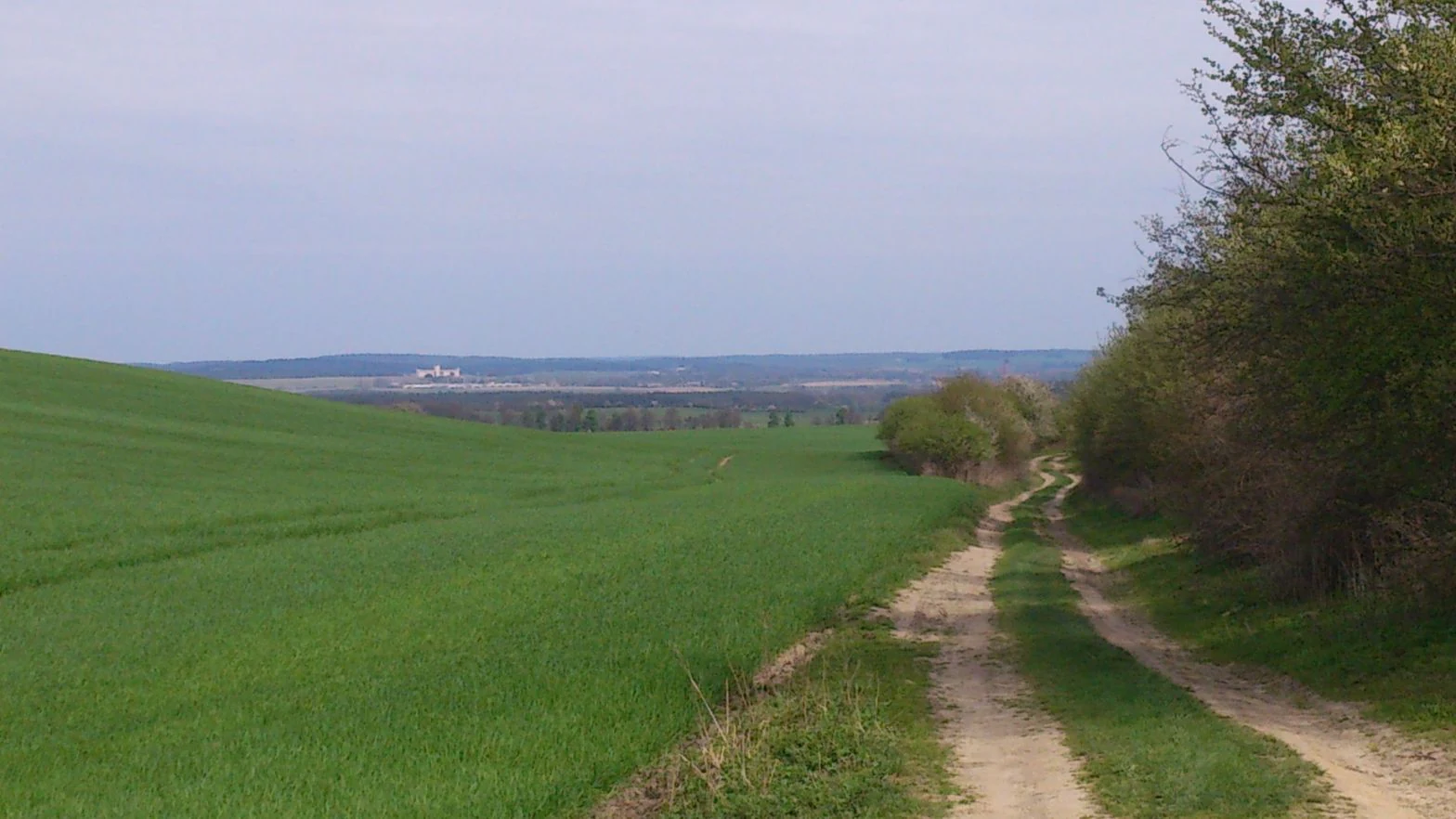
A dirt track follows the edge of a lush green agricultural field towards a distant tree line and rolling horizon under an overcast sky.
A dirt path winding through the green hills of Wzgórza Krzymowskie.

Wzgórza Krzymowskie history and protected-area timeline

In its geological sense, the history of Wzgórza Krzymowskie extends back to the Pleistocene, when successive glaciations of the North European plain left behind the moraine ridges, kettle depressions, and outwash surfaces that define the modern topography. Following the retreat of the ice, aeolian processes shaped inland dunes between Bielinek and Piasek that were later stabilized by the forests of Puszcza Piaskowa.

In the modern administrative sense, the microregion was formalized through Poland's physical-geographical regionalization. It lies within the Central European Plain province, the South Baltic Lakelands sub-province, the West Pomeranian Lakeland macroregion, and the Myślibórz Lakeland mesoregion, with Wzgórza Krzymowskie itself treated as a distinct microregion. Most of its territory falls within Gryfino County and across the gminas of Cedynia, Chojna, and Moryń.

Conservation history developed largely in the early twenty-first century. The Cedyński Landscape Park, which encompasses most of the hills, was in place before the Natura 2000 designation, and the Wzgórza Krzymowskie special area of conservation was established under the European ecological network. In 2009, the municipal council of Cedynia adopted a formal opinion (resolution XXIX/273/09) supporting that Natura 2000 designation as a special habitat protection area, marking a key step in cementing the region's protected status.

Wzgórza Krzymowskie landscape and geographic character

The landscape of Wzgórza Krzymowskie is a textbook example of Polish postglacial relief compressed into a relatively small area. The dominant landforms are moraine hills, or pagórki morenowe, whose rounded ridges and gentle slopes alternate with small lakes, kettle hollows, and water-filled depressions. The highest of these hills is Zwierzyniec, reaching around 167 meters above sea level, which serves as both a summit landmark and a key viewpoint in the area.

The western flank of the hills has a very different character. There, the moraine terrain gives way to a sharp escarpment that plunges toward the Lower Oder Valley (Dolina Dolnej Odry). Streams have carved narrow, deep ravines, locally called jary, into this edge, producing a fragmented slope of gullies, ravines, and small valleys. Numerous springs, or źródliska, emerge at the base of the escarpment and feed streams that flow westward as tributaries of the Oder.

Between Bielinek and Piasek, a Pleistocene plain extends across the southern fringe of the microregion. Wind action across this sandy surface built inland dunes, and over time these dunes were fixed by the forests of Puszcza Piaskowa. The result is a layered landscape: ice-built ridges in the interior, a steep forested edge above the Oder, and a dune-influenced sandy plain to the south, all within a few kilometers of one another.

Wzgórza Krzymowskie ecosystems, habitats, and plant life

Ecologically, Wzgórza Krzymowskie sits at the intersection of three landscape types: postglacial moraine forests, sandy outwash forests, and dry-ground habitats connected to old dunes and inland dune fields. The dominant vegetation is the pine-rich forest of Puszcza Piaskowa, which covers much of the central portion of the hills and gives the region its name-derived identity as a sandy-forest landscape. Around this forest core, mixed forest patches, small wetlands, and spring-fed alder-ash communities follow the valleys and streamheads.

Habitats along the western escarpment are particularly significant. The convergence of slope springs, streams cutting into the Oder valley margin, and adjacent forest stands creates a zone of wet woodland, marshy headwaters, and small open water that is rare within the surrounding lowlands. Inland dunes stabilized by forest host their own distinctive dry-ground flora, and within the broader Cedyński Landscape Park reserves such as Dąbrowa Krzymowska, Olszyny Ostrowskie, and the spring alder forest of Lubiechów Dolny preserve representative fragments of these habitat types.

The combined ecological value of these patterns is recognized formally through the Cedyński Landscape Park, which covers most of the microregion, and through the Wzgórza Krzymowskie Natura 2000 special area of conservation. Together, these designations protect a coherent mosaic of moraine forest, sandy-pine forest, springhead wetlands, and dry-ground habitats within a single, clearly bounded geographic unit.

Wzgórza Krzymowskie wildlife and species highlights

Wzgórza Krzymowskie supports wildlife communities typical of the Polish West Pomeranian lake-district and sandy-forest transition. Large continuous tracts of forest, including the pine-dominated Puszcza Piaskowa, provide habitat for forest-associated species, while the mosaic of lakes, kettle ponds, and stream valleys supports amphibians, wetland birds, and invertebrates linked to spring-fed habitats.

The moraine ridges and ravines along the Oder escarpment add structural diversity by offering shelter, slope microclimates, and old-growth patches. This landscape configuration, together with the protected status of the area, makes the microregion a useful site for observing lowland forest fauna in a setting where glacial topography and sandy substrates intersect.

Wzgórza Krzymowskie conservation status and protection priorities

Conservation significance for Wzgórza Krzymowskie rests on a layered system of protection. Most of the microregion falls within the Cedyński Landscape Park (Cedyński Park Krajobrazowy), a regional form of Polish landscape protection designed to maintain the scenic, ecological, and cultural value of an area. Within that landscape park, several strict nature reserves, including Bielinek, Dąbrowa Krzymowska, Dolina Świergotki, Olszyny Ostrowskie, Olszyna Źródliskowa pod Lubiechowem Dolnym, Wrzosowiska Cedyńskie, and Słoneczne Wzgórza, protect specific forest, heath, and spring communities, while natural monuments preserve selected individual features of natural value.

At the European level, the central and southeastern parts of the hills are designated as the Wzgórza Krzymowskie special area of conservation within the Natura 2000 ecological network. This designation focuses on preserving habitat types characteristic of the moraine and sandy-forest landscape, including dry-ground habitats, springhead woodlands, and forests tied to glacial landforms. In 2009, the Municipal Council of Cedynia adopted a formal resolution supporting this Natura 2000 designation, anchoring it within local land-use planning.

Taken together, the landscape park, individual reserves, and Natura 2000 status give the microregion one of the densest conservation frameworks in the West Pomeranian lowlands, ensuring that the glacial-sandy landscape remains a coherent protected unit rather than a fragmented mosaic.

Wzgórza Krzymowskie cultural meaning and human context

The microregion is intimately tied to the small historic towns that border it, including Cedynia, Chojna, Moryń, Bielinek, and a string of villages such as Krzymów, Krajnik Dolny and Górny, Lubiechów Dolny and Górny, Osinów Dolny, Piasek, Raduń, and Stoki. These settlements form the cultural backbone of the area and have long been associated with agriculture, forestry, and trade routes along the Oder.

Cultural landmarks within and around the Wzgórza include the memorial on Góra Czcibora commemorating the early medieval Battle of Cedynia, the lookout points associated with towers in Cedynia and on Zwierzyniec, and the so-called Dolina Miłości, a romantic landscape feature near Zatoń Dolna that has become a small-scale regional attraction. The terrace view from the Mariacki Church tower in Chojna, looking east over the hills and forests, anchors the medieval townscape to the surrounding moraine scenery and represents the kind of long-standing dialogue between human settlement and glacial landscape that defines much of Polish lowland heritage.

Top sights and standout views in Wzgórza Krzymowskie

Wzgórza Krzymowskie combines glacial moraine topography with sandy-forest landscapes above the Lower Oder Valley, producing a lowland scenery that is unusually varied for northwestern Poland. The summit Zwierzyniec anchors the highest ground, the Cedyński Landscape Park wraps the area in formal protection, and the Wzgórza Krzymowskie Natura 2000 site adds European-level habitat importance.

Additional highlights include the network of observation towers at Cedynia and Zwierzyniec, the ravine-cut western escarpment with its spring complexes and tributaries of the Oder, the inland dune field between Bielinek and Piasek, and the system of marked trails such as the Nadodrzański Trail, the Moraine Hills Trail, and the Chojeńskie Lakes cycling route. Together, these features give the microregion both ecological depth and a strong identity as a regional landscape destination.

Best time to visit Wzgórza Krzymowskie

The character of Wzgórza Krzymowskie shifts meaningfully across the seasons. Spring is a favorable time for visiting the springhead complexes and stream valleys along the western escarpment, when snowmelt and groundwater feed active flows and the surrounding broadleaf and alder stands come into leaf. The forest trails crossing Puszcza Piaskowa and the ridges around Zwierzyniec are also most comfortable before the warmest summer weather, and viewpoints overlooking the Lower Oder Valley tend to be at their clearest.

Summer brings the longest days for sunrise and sunset viewing points across the moraine ridges, lakes such as Ostrów and Mętno, and the inland dunes between Bielinek and Piasek, though forested sections can be quieter earlier in the day. Autumn is particularly notable for color across the mixed forests, with the brick-red of Dąbrowa Krzymowska and the heath vegetation of Wrzosowiska Cedyńskie giving the region strong photographic character, while winter settles relatively lightly over the lowland hills, keeping the lookout points and trails accessible except in heavier frosts.

Monthly climate preview

Long-term representative measurements of monthly temperature and precipitation patterns

Wzgórza Krzymowskie Climate Normals and Annual Temperature Rhythm

Representative coordinate records show average monthly temperatures ranging from sub-zero winter minimums to peak summer maximums alongside stable daily precipitation values. Examining the complete twelve-month climatology profile reveals granular shifts across the entire annual cycle.
Annual mean9 °C
-1 °C20 °C
Jan-1°
Feb
Mar
Apr
May13°
Jun17°
Jul20°
Aug19°
Sep15°
Oct
Nov
Dec
Warmest month
July

19.8 °C

Coolest month
January

-1.2 °C

Wettest month
July

2.5 mm/day

Driest month
April

1.1 mm/day

Park location guide

Geography guide, regional context, and park location map for Wzgórza Krzymowskie

Wzgórza Krzymowskie park geography, regions, and map view in Poland

Understand where Wzgórza Krzymowskie sits in Poland through a broader geographic reading of the surrounding landscape, nearby location context, and its mapped position within the national park landscape.

How Wzgórza Krzymowskie fits into Poland

Poland, officially the Republic of Poland, is a Central European country spanning from the Baltic Sea in the north to the Carpathian Mountains in the south. It borders Germany, Czech Republic, Slovakia, Ukraine, Belarus, Lithuania, and Kaliningrad Oblast. The country has a temperate climate, diverse landscapes, and is known for its rich history, cultural heritage, and strong economic position within the EU.

Wider geography shaping Wzgórza Krzymowskie in Poland

Poland occupies 312,696 km2 in Central Europe, extending from the Baltic Sea coast in the north to the Sudetes and Carpathian Mountains in the south. It borders Germany to the west, Czech Republic and Slovakia to the south, Ukraine and Belarus to the east, and Lithuania and Kaliningrad Oblast to the northeast. The landscape includes lowland plains, uplands, and mountain ranges.

Map view of Wzgórza Krzymowskie

Use this park location map to pinpoint Wzgórza Krzymowskie in Poland, understand its exact geographic position, and read its mapped placement within the surrounding landscape more clearly.

Pigeon | © OpenStreetMap contributors

Location context for Wzgórza Krzymowskie

West Pomeranian Voivodeship

Explore photographic records of glacial terrain, escarpments, and protected habitats in Poland.

Wzgórza Krzymowskie Photos and Landscapes: Visualizing Moraine Hills and Forest Scenery

Visual documentation captures the complex postglacial relief, forested dunes, and steep escarpments dropping toward the Lower Oder Valley. Examining these photographic records helps researchers and naturalists interpret the geomorphology and protected landscape character of the region.

A dirt track follows the edge of a lush green agricultural field towards a distant tree line and rolling horizon under an overcast sky.

Park atlas

Compare adjacent glacial landscapes and surrounding protected terrain across the region.

Other Parks and Protected Areas Near Wzgórza Krzymowskie in Regional Context

Visitors exploring the moraine hills of Wzgórza Krzymowskie can continue browsing nearby protected areas and connected regional landscapes. Such comparison provides broader geographic context for postglacial terrain and surrounding lowland reserves.
Protected landscapeWest Pomeranian Voivodeship
Park boundaries overlap#1 closest

Southwest

Cedynia Landscape Park: Mapped Protected Landscapes and Regional Geography in Poland

Protected mosaic of sandy forests and river valleys

Spanning 308 square kilometers, Cedynia Landscape Park protects a complex transition zone in Poland. The area features the expansive Puszcza Piaskowa pine forests, the hilly moraine relief of the Cedynia Carpathians, and the biodiverse wetlands of the lower Oder River. This protected landscape represents an essential study in lowland ecological gradients and postglacial terrain development within the West Pomeranian Voivodeship.

Area
308.5 km²
Established
1993
Relief
Upland
Climate
Temperate
Watercolor painting depicting a river flowing through a valley with green vegetation and distant mountains
National parkBrandenburg
3.1 km away#2 closest

North

Lower Oder Valley National Park: Unique Polder Landscape and Bird Sanctuary

Discover protected area maps and regional geography in Brandenburg

Delve into the Lower Oder Valley National Park, a national park recognized for its extraordinary polder landscape and extensive wetland ecosystems. This page provides detailed geographic context, highlighting the park's unique engineered floodplain, its role as a sanctuary for numerous bird species, and its position within the regional geography of Brandenburg. Understand the mapped boundaries and ecological importance of this exceptional protected area.

Area
103.23 km²
Established
1995
IUCN
II
Visitors
150K annual
Watercolor painting of a lake surrounded by green trees, grassy banks, and soft rolling hills under a pale sky.
Protected areaBrandenburg
9.5 km away#3 closest

Northwest

Felchowseegebiet Protected Area: Mapped Glacial Lakes and Woodland in Brandenburg

Examining the ecological landscape and forest boundaries of the Uckermark region

Felchowseegebiet functions as a vital refuge for aquatic and forest species in Brandenburg. This protected landscape is defined by its glacial lakes, including the central Felchowsee, which are framed by forests managed for natural development. The area offers a detailed view of the Uckermark terrain, highlighting the interaction between moist woodland and protected water surfaces in northeastern Germany.

Area
9.72 km²
Established
2003
Relief
Lowland
Climate
Temperate
Watercolor illustration showing a winding river through a soft, green wetland landscape with distant rolling hills and scattered trees.
Protected areaLubusz Voivodeship
14 km away#4 closest

Southeast

Ostoja Witnicko-Dębniańska: Mapped Protected Area and Regional Geography

An extensive mosaic of lowland forest and wetland habitats in Poland

The Ostoja Witnicko-Dębniańska sanctuary serves as a critical protected landscape, defined by its blend of managed forest stands, transitional peatlands, and dystrophic lakes. Positioned along the Warta river valley, this area provides a rich geographic context for understanding the wetland ecosystems of the Lubusz Voivodeship and the surrounding western Polish lowlands.

Area
469.93 km²
Established
2007
Scope
Terrestrial
Water
Major water bodies
Nature reserveBrandenburg
20 km away#5 closest

Southwest

Tongruben Neuenhagen Nature Reserve: Protected Wetland Geography in Brandenburg, Germany

Examining post-industrial clay-pit habitats and protected wetland boundaries

Tongruben Neuenhagen is a designated nature reserve located in Brandenburg, Germany, established to protect biological communities that have developed within former clay extraction pits. The area features a complex mosaic of open water, wetland margins, and transitional scrub habitats. This reserve provides a notable example of how historical industrial land use can be repurposed into valuable habitat for protected species, serving as a key element of the local conservation network in the Märkisch-Oderland region.

Area
1.196 km²
Established
1990
IUCN
IV
Relief
Lowland
Protected landscapePoland
26 km away#6 closest

South

Park Krajobrazowy Ujście Warty: Protected Landscape and River Valley Atlas

Mapping wetland ecosystems and floodplain geography in western Poland

Park Krajobrazowy Ujście Warty preserves a significant lowland river valley landscape characterized by vast open pastures, marshes, and rare riparian oak forests. Located primarily within the Lubuskie region, this protected area offers a clear view into the floodplain processes of the Warta river basin, providing a distinct geographic context for wetland conservation and waterbird habitat mapping in Poland.

Area
194.96 km²
Established
1996
Relief
Lowland
Climate
Temperate
Watercolor painting of a green valley with a meandering stream and a cluster of trees against a light background.
Nature reserveBrandenburg
27 km away#7 closest

Southwest

Cöthener Fließtal Nature Reserve in Brandenburg: Glacial Geography and Protected Woodland Atlas

Mapping the stream corridors and moraine landscapes of eastern Brandenburg

Cöthener Fließtal is a 75-hectare protected area that bridges the hilly Barnim plateau and the Oderbruch lowlands. The site features a dense concentration of glacial landforms, including end-moraine ridges and spring-fed mires. Visitors can explore the interplay between natural forest ecosystems and the restored elements of a historic nineteenth-century landscape park found along the Cöthener Fließ stream.

Area
0.75 km²
Established
2003
IUCN
IV
Relief
Upland
Protected areaBrandenburg
33 km away#8 closest

Northwest

Suckower Haussee Protected Area: Geographic Overview and Habitat Mosaic in Uckermark, Brandenburg

Mapping spring mires, wet meadows, and dry grassland ecosystems

Suckower Haussee preserves a diverse habitat gradient typical of the Uckermark district. The protected area features a unique juxtaposition of limnic, peat-forming wetland habitats and nutrient-poor dry grasslands. This site acts as an essential component of the regional conservation network in northeastern Brandenburg, demonstrating the importance of small-scale landscape protection.

Area
1.37 km²
Established
1990
Scope
Terrestrial
Water
Major water bodies

Common questions about visiting, size, designation, and location context for Wzgórza Krzymowskie

Wzgórza Krzymowskie FAQs for park facts, access, geography, and protected area context

Find quick answers about Wzgórza Krzymowskie, including protected-area facts, park geography, trail and visitor context, and how the park fits into its surrounding country and regional landscape.
MoriAtlas Explorer

Continue Your Protected Areas Search Across the Global Atlas

Deepen your exploration by continuing the structured search for national parks and protected areas worldwide. Utilize the comprehensive filtering capabilities to compare different conservation landscapes and refine your understanding of global park geography. Discover more about the distribution and characteristics of protected natural areas.

Global natural geography