
Capes
Park geography
Technical overview of protected area extent, elevation, and regional terrain characteristics
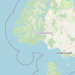
Geographic Profile and Mapped Boundaries of Fiordland National Park in the Southland Region
Examine the detailed geographic structure of Fiordland National Park, encompassing 12,607 square kilometers across the Southland Region of New Zealand. This profile details boundary dimensions, mountain terrain relief, and physical features including river systems, ridges, and coastal environments.
Related tags
Temperate RainforestGlacial LandscapeUNESCO World Heritage SiteFiordsEndemic Wildlife
New Zealand's largest national park, protecting glacier-carved fiords and temperate rainforests in the southwestern South Island
Fiordland National Park
Fiordland National Park is the largest of New Zealand's thirteen national parks, encompassing 12,607 square kilometres of spectacular southwestern South Island terrain. The park is defined by its dramatic glacier-carved fiords, with Milford Sound / Piopiotahi being the most famous, along with Doubtful Sound / Patea and Tamatea / Dusky Sound. The southern ranges of the Southern Alps dominate the interior, creating a highly inaccessible landscape of steep valleys, towering peaks exceeding 2,500 metres, and remote wilderness. The park's extraordinary high rainfall, exceeding seven metres annually, supports the largest area of unmodified vegetation in New Zealand, including vast temperate rainforests of silver beech and mountain beech. Established in 1952, Fiordland forms the core of the Te Wāhipounamu World Heritage Area, recognized in 1990 for its outstanding natural significance. The park serves as a critical refuge for many of New Zealand's most endangered native species, including the takahē, kākāpō, mōhua, and southern brown kiwi.
- Location
- New Zealand
- Park type
- National park
- Established
- 1952
- Area
- 12,607 km²
- Highest point
- 2,500 m
Location overview
Southland Region boundaries and coastal island status in New Zealand
Geographic Location and Territory of Fiordland National Park
Fiordland National Park occupies a defined territory within the Southland Region of New Zealand. The protected area carries coastal, island, and marine classifications under a single country jurisdiction.
- Countries
- New Zealand
- Regions
- Southland Region
- Primary location
- Southland Region
- Geographic setting
- Coastal · Island · Marine
Boundary and coordinates
Boundary dimensions and coordinates covering 12,607 square kilometers
Fiordland National Park Boundary Map and Spatial Dimensions
Interactive mapping outlines the spatial context of Fiordland National Park. Structured geographic data details the total land area, coordinate limits, and center points across the region.
- Boundary area
- 12,738.6 km²
- Boundary perimeter
- 2,391 km
- Northernmost point
- 44.3319° S
- Southernmost point
- 46.2512° S
- Easternmost point
- 168.2398° E
- Westernmost point
- 166.4256° E
- Geographic centre
- 45.389° S, 167.3431° E
- North–south span
- 213.3 km
- East–west span
- 142.3 km
Elevation and terrain
Mountain relief metrics and recorded physical features
Fiordland National Park Terrain and Elevation Summary
Recorded elevation metrics outline a vertical range spanning from sea level up to two thousand five hundred meters. Linked feature cards supply names, types, and spatial relationships for streams, ridges, and lakes located within the protected area.
- Minimum elevation
- 0 m
- Maximum elevation
- 2,500 m
- Highest point
- 2,500 m
Selected named natural features
Capes
Five Fingers Point
Capes
Fixed Head
Capes
Anchor Point
Capes
Chalky Point
Capes
Pridham Point
Environmental setting
Temperate climate zones, dominant forest cover, and glacial relief features
Fiordland National Park Environmental Classification and Physical Setting
Recorded landscape features and habitat types unite to frame the physical setting of Fiordland National Park across distinct temperate environments. Stored environmental categories connect directly to related protected areas and mapped atlas destinations.
- Relief
- Mountain
- Climate
- Temperate
- Water
- Water-dominated
- Forest cover
- Dense forest cover
- Seasonality
- Strongly seasonal
Landscape features
Mountains · Valleys · Cliffs · Forest · Lakes · Rivers · Waterfalls · Coast · Islands · Glacier
Habitat types
Temperate broadleaf forest · Temperate coniferous forest · Montane forest · Glacial habitat · Lacustrine habitat · Riverine habitat · Coastal habitat
Park atlas
Compare the diverse glacial landscapes and protected wilderness areas across New Zealand's South Island.
Discover Related National Parks and Protected Areas Near Fiordland National Park
Browse other national parks and protected areas across New Zealand's South Island, expanding your geographic discovery beyond Fiordland National Park to trace connected wilderness and diverse conservation landscapes. Compare varied alpine environments, temperate rainforests, and glacial fiord systems, offering a comprehensive atlas perspective on regional park geography.
Marine protected areaFiordland
Park boundaries overlap#1 closest
North

Hawea (Clio Rocks) Marine Reserve: Protected Marine Geography in Fiordland, New Zealand
Mapping vertical rock walls and stratified fiord water ecosystems.
Hawea (Clio Rocks) Marine Reserve is an ecologically significant marine protected area situated within the deep waters of Hāwea / Bligh Sound. The reserve is defined by its dramatic vertical rock walls, tidal current channels, and the complex water stratification that sustains diverse black coral and reef communities. It offers a unique window into the geological and marine processes that have shaped the rugged coastal landscape of New Zealand's Fiordland.
- Area
- 4.11 km²
- Established
- 2005
- IUCN
- Ia
- Relief
- Mountain
Marine protected areaFiordland
Park boundaries overlap#2 closest
Northwest
Kahukura (Gold Arm) Marine Reserve: Marine Protected Area and Fiordland Geographic Atlas
Submerged rocky reefs and vertical rock wall landscapes
Located in the heart of New Zealand, Kahukura (Gold Arm) Marine Reserve provides a vital map of protected coastal terrain. Its unique environment features freshwater caps, tannin-stained deep water, and diverse marine topography ranging from sheltered basin ecosystems to vertical cliff structures. This marine area offers deep insight into the complex geology and conservation dynamics of the Fiordland region.
- Area
- 4.64 km²
- Established
- 2005
- Relief
- Mixed relief
- Climate
- Temperate
Marine protected areaFiordland
Park boundaries overlap#3 closest
West
Kutu Parera (Gaer Arm) Marine Reserve: Fiordland Protected Marine Landscape Atlas
Mapped marine boundaries, stratified fiord ecology, and coastal terrain analysis
Explore the structured geography of Kutu Parera (Gaer Arm) Marine Reserve, a 433-hectare protected area located within the steep, mountain-flanked fjords of New Zealand. Gain insight into its complex underwater features, including vertical rock walls, estuarine basins, and stratified water columns that define this unique marine environment within the Fiordland region.
- Area
- 4.33 km²
- Established
- 2005
- Relief
- Mixed relief
- Climate
- Temperate
Marine protected areaFiordland
Park boundaries overlap#4 closest
West
Moana Uta (Wet Jacket Arm) Marine Reserve: Mapped Protected Landscapes in Fiordland
Exploring unique fiord stratification and dense marine coral habitats
Located in the remote southwestern reaches of New Zealand, Moana Uta (Wet Jacket Arm) Marine Reserve preserves a complete fiord system. The area is notable for its exceptional physical conditions, including high black coral density and a distinct freshwater surface layer that sustains diverse underwater communities across steep rock walls, reefs, and deep basins.
- Area
- 20.07 km²
- Established
- 2005
- Relief
- Lowland
- Climate
- Temperate
National parkOtago
Park boundaries overlap#5 closest
Northeast
Mount Aspiring National Park: Glaciated Alpine Wilderness & Protected Landscape Atlas
Explore the U-shaped valleys and mapped boundaries of this iconic national park.
Mount Aspiring National Park showcases a breathtaking glacial landscape defined by steep-sided U-shaped valleys, active glaciers, and soaring alpine summits. As a designated national park within New Zealand's South Island, its protected status preserves a vast area of wilderness crucial for understanding regional geography and alpine terrain. This page provides an atlas-style exploration of its mapped boundaries and the stark, natural beauty that characterizes this significant conservation landscape in the Otago region.
- Area
- 3,562 km²
- Established
- 1964
- IUCN
- II
- Relief
- Mountain

Marine protected areaFiordland
Park boundaries overlap#6 closest
North
Piopiotahi (Milford Sound) Marine Reserve: Mapped Protected Area and Fiord Geography
A signature marine landscape within New Zealand's Fiordland region.
Piopiotahi (Milford Sound) Marine Reserve protects a distinct underwater environment characterized by dramatic vertical rock walls and deep basins. By examining the geographic boundaries and oceanographic layering of this Fiordland site, users can better understand the interplay between the steep forested cliffs above and the thriving coral and marine wildlife habitats below the surface.
- Area
- 6.9 km²
- Established
- 1993
- Relief
- Mountain
- Climate
- Temperate
Marine protected areaFiordland
Park boundaries overlap#7 closest
West
Taipari Roa (Elizabeth Island) Marine Reserve: Fiordland Marine Landscape and Atlas Map
Protected marine terrain and glacial fjord geography
Taipari Roa (Elizabeth Island) Marine Reserve is a protected marine area situated within the complex fjord network of Doubtful Sound. The reserve is characterized by steep underwater rock walls, deep kelp forests, and a unique freshwater cap that allows rare corals and glass sponges to thrive at shallow depths. This geographic overview examines the reserve's protected status and its structural role within the broader Fiordland ecosystem, highlighting the vertical aquatic terrain and surrounding islet environments.
- Area
- 6.13 km²
- Established
- 2005
- Relief
- Lowland
- Climate
- Temperate
National parkNew Zealand
57 km away#8 closest
South
Rakiura National Park: New Zealand's Remote Protected Wilderness & Landscape Atlas
Explore its rugged terrain and unique subantarctic ecosystem.
Rakiura National Park encompasses the majority of Stewart Island, offering a unique glimpse into one of New Zealand's most remote and undisturbed natural environments. This protected landscape features rugged forested hills, extensive coastlines with isolated beaches, and is globally recognized for its abundant kiwi populations. Discover the park's geographic setting and its significance as a protected area for both wildlife and cultural heritage within the broader atlas of New Zealand's natural wonders.
- Area
- 1,399.6 km²
- Established
- 2002
- IUCN
- II
- Relief
- Lowland
MoriAtlas Explorer
Continue Exploring Fiordland National Park's Dramatic Geography and Protected Landscapes
Delve deeper into the mapped geography and protected-area context of Fiordland National Park. Understand its unique glacial landforms, vast alpine wilderness, and the significance of its ancient temperate rainforests. This exploration reveals the core of the Te Wāhipounamu World Heritage Area and the intricate natural systems that define this remarkable New Zealand national park.
Browse next
Global natural geography
Explore related park routes
Explore MoriAtlas Global ParksBrowse All MoriAtlas ParksGlobal Park Map DiscoveryMoriAtlas: Browse All CountriesBrowse All MoriAtlas ContinentsNational Park Environment AtlasGrand Canyon National Park AtlasYellowstone National Park AtlasYosemite National Park Atlas and GeographySerengeti National Park AtlasGalápagos National Park Protected LandscapeBanff National Park Geography and AtlasKruger National Park Atlas EntryUluṟu-Kata Tjuṯa National Park AtlasExplore Uluru-Kata Tjuta National Park GeographyPlitvice Lakes National Park AtlasFiordland National Park Protected LandscapeGreat Smoky Mountains National Park AtlasAfghanistan National Parks and Protected AreasAlbania National Parks and Protected AreasAlgeria National Parks and Protected AreasAmerican Samoa National Parks and Protected AreasAndorra National Parks and Protected AreasAngola National Parks and Protected AreasAntarctica National Parks and Protected AreasAntigua and Barbuda Park List