
Mori Atlas logo
Nature reserveGeorgewitzer Skala

Tracing the geological evolution and forested slopes of a classic Upper Lusatian skala valley

Georgewitzer Skala Nature Reserve: A Deeply Incised Granodiorite Gorge in Saxony

Georgewitzer Skala forms a distinctive protected rock gorge along the Löbauer Wasser within the rolling landscape of the Upper Lusatian highlands. This nature reserve, centered in the Landkreis Görlitz district of Saxony, preserves a complex mosaic of near-natural deciduous forest communities and granodiorite rock formations. The valley illustrates the intersection of ancient geological processes and human history, featuring historical earthworks and mill ruins nestled within its steep, forested ravine flanks.

rock gorgegranodiorite valleydeciduous forestoak-hornbeam forestriparian woodlandprotected nature reserve
A digital illustration of a forested canyon featuring a waterfall cascading into a rocky stream with a small wooden footbridge on the right bank.

Georgewitzer Skala

Nature reserve

Park overview

Structured park overview, official facts, and landscape profile for Georgewitzer Skala

Georgewitzer Skala park facts, protected area profile, and essential visitor context

Review the core facts for Georgewitzer Skala, including designation, size, terrain, visitor scale, habitats, and operating context in one park-focused overview.

About Georgewitzer Skala

Georgewitzer Skala lies in the eastern part of Saxony, within the Oberlausitzer Gefilde, a gently undulating highland district in the Upper Lusatia region where small rivers have repeatedly cut narrow, cliff-side valleys through the local bedrock. The reserve protects one of the most characteristic of these gorges: a roughly 1.3 kilometer long stretch of the Löbauer Wasser where the watercourse runs from south to north between the localities of Georgewitz and Oppeln, just north of Löbau. The protected area was formally designated in 1961, initially on the strength of two reinforcing qualities: the geomorphological distinctiveness of the valley itself, and the unusually rich and natural character of its deciduous forest cover.

The reserve is a small but ecologically coherent protected landscape. Its boundary is marked by a sharp transition from closed woodland to surrounding open farmland, which highlights how the valley has preserved a continuous forest cover while the surrounding plateau remained under cultivation. Within that forest frame, the valley floor carries a near-natural, block-rich bed of the Löbauer Wasser, while the slopes rise steeply on both sides in a sequence of rock walls, fissures, and wooded inclines. The valley's elevations step upward from about 210 meters above sea level at the riverbed to approximately 240 meters where the slopes ease into the surrounding upland surface.

Geologically, the valley has been incised over thousands of years into the West Lusatian granodiorite, locally described as a two-mica granodiorite. The surface cover above the bedrock is dominated by loess loam and river gravels dating from the Weichselian glaciation, giving the upper soils a nutrient-rich character that contributes to the diversity of forest types below. The combination of rocky slopes, a natural stream channel, and fertile but well-drained soils supports a layered vegetation pattern that changes quickly from waterside to ridge.

The reserve forms part of a broader family of similar skala landforms across Upper Lusatia, alongside familiar neighboring examples such as the Gröditzer Skala and Lausker Skala, and together these narrow rock valleys define a recognizable regional landscape type. Within that wider group, Georgewitzer Skala stands out for the compactness of its protected area, the diversity of its forest communities, and the presence of historical sites embedded directly within the gorge, including a Slavic-era rampart, an ancient trade route, and a centuries-old mill building.

Quick facts and research context for Georgewitzer Skala

Georgewitzer Skala is a small Saxon nature reserve of around 34 hectares located in the Landkreis Görlitz, north of the town of Löbau. It was designated in 1961, primarily because of its distinctive geomorphological character and its stands of near-natural deciduous forest. The protected area follows a roughly 1.3 kilometer long section of the Löbauer Wasser where the river has carved a narrow gorge through West Lusatian granodiorite. The reserve's boundary is largely defined by a sharp forest-to-field edge, marking a clear transition between woodland and surrounding agricultural land. The valley rises from about 210 meters above sea level at the streambed to roughly 240 meters on the wooded slopes above.

Protection and recognition

Explore the documented terrestrial conservation scope and official establishment timeline.

Georgewitzer Skala Protection Status and Designation History

Georgewitzer Skala maintains a documented terrestrial protection status established in 1961. Structured conservation records provide clear insight into the official designation history and management scope of this protected area.

Protection details

Protection scope
Terrestrial
Designated year
1961
Park context

Deeper park guide and search-rich context for Georgewitzer Skala

Georgewitzer Skala history, landscape, wildlife, and travel context

Explore Georgewitzer Skala through its history, landscape character, ecosystems, wildlife, conservation priorities, cultural context, and seasonal travel timing in a structured park guide built for atlas discovery and search intent.

Why Georgewitzer Skala stands out

Georgewitzer Skala is best known for its compact but well-defined granite gorge, a striking example of the skala landforms that characterize the Upper Lusatian landscape. The reserve protects a continuous mosaic of near-natural deciduous forest communities on steep slopes, including linden-rich oak-hornbeam stands, hornbeam-rich sessile oak-beech forest, and black alder riverside communities along a near-natural rocky streambed. The locality is also recognized for small but ecologically meaningful occurrences of protected plant species linked to the weakly alkaline soils derived from granodiorite, and for characteristic woodland avifauna such as kingfisher, lesser spotted woodpecker, and grey wagtail along the watercourse.
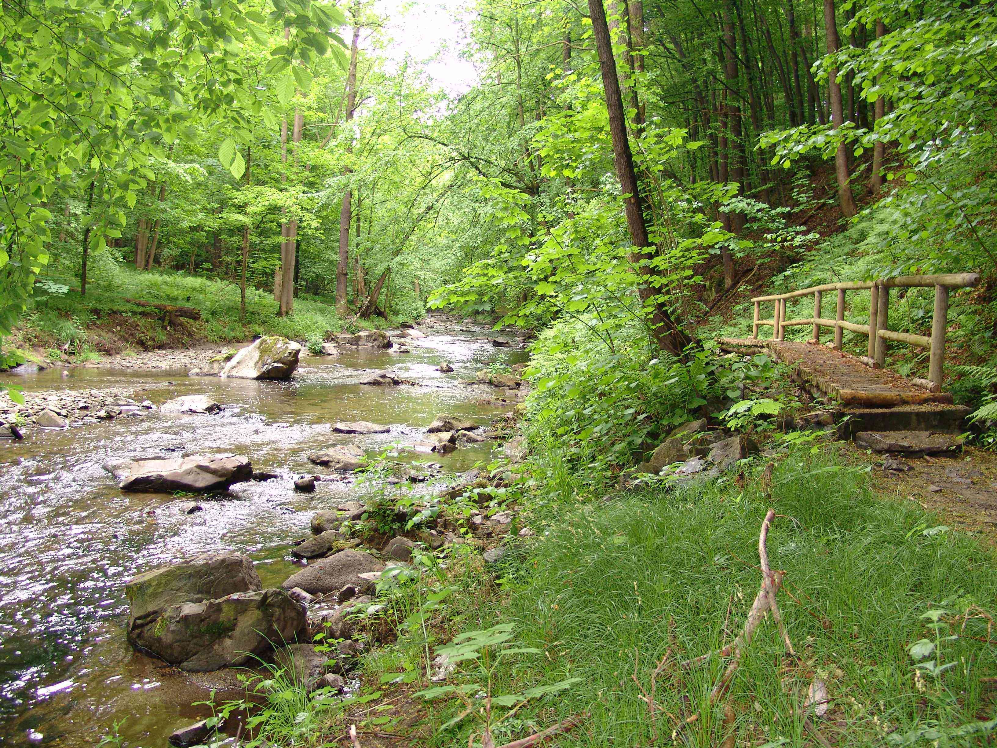
A shallow, rocky stream winding through a dense, vibrant green forest, with a wooden footbridge visible on the bank.
The Loebauer Wasser stream flowing through the lush, wooded valley of Georgewitzer Skala.

Georgewitzer Skala history and protected-area timeline

The natural features of the valley are matched by a long human history written into its slopes and roadside edges. Among the oldest visible traces is the Bielplatz, a Slavic section wall (Abschnittswall) generally dated to around the year 1000, which is recorded as a cultural monument within the reserve. A short distance away, the strata antiqua, an ancient Saxon trade road, once passed the valley on its way through Göda near Bautzen toward Jauernick-Buschbach near Görlitz and onward into Silesia. Traveling merchants using that route paid way tolls at a feature known as the Alte Schanze, an earthwork of Slavic origin later associated with early German settlement, dated to around 1100 and still recognizable in the landscape today.

Below the settlement of Georgewitz, the valley also contains the so-called Gemauerte Mühle, a stone-built mill first documented in 1425. The mill maintained a grain-grinding operation until a robber attack in 1807 led to its closure and eventual sale. The building later gained wider historical notice when Field Marshal Gebhard Leberecht von Blücher, campaigning against Napoleon in 1813, reportedly used it as quarters between 23 and 26 May of that year while establishing a field camp in the area.

The valley's most famous single rock formation, the Rittersprung, carries a popular local legend set around 1800. According to tradition, a local lord pursuing a maidservant from Bellwitz on horseback attempted to follow her by leaping his horse across the rock; the horse failed to stop in time and both horse and rider fell from the cliff with a scream that, according to folklore, can still be heard on quiet nights. The legend gives the rock its name and remains part of the cultural memory attached to the gorge.

Today, the upper edge of the reserve is touched by a section of the Lausitzer Schlange, a long-distance regional hiking trail running between Löbau and Zoblitz. That path passes to the east of the protected area and gives visitors a convenient way to approach the valley from the surrounding uplands without entering the protected forest itself.

Georgewitzer Skala landscape and geographic character

Georgewitzer Skala is a classic narrow rock-walled valley, the kind of landform in Upper Lusatia known locally as a skala, a term of Slavic origin simply meaning rock or cliff. The valley runs from south to north along the course of the Löbauer Wasser and is one of several similar gorges that give the Oberlausitzer Gefilde its distinctive texture, sitting alongside comparable features such as the Gröditzer Skala and the Lausker Skala.

The underlying geology is dominated by the West Lusatian granodiorite, including a local two-mica granodiorite variety that has been slowly worn away over thousands of years by the river's erosive action. The result is a tight, fissure-rich gorge with steep wooded flanks, exposed rock faces along the slopes, and a near-natural stream channel filled with larger boulders where the river still runs freely over its rocky bed. In the upper layers of soil and across the upland that frames the valley, the bedrock is masked by loess loam and river gravels left behind during the Weichselian glaciation, producing nutrient-rich land above while leaving the rock-controlled valley below.

The vertical profile of the valley is modest but well defined: the streambed sits at around 210 meters above sea level, while the forested slopes rise to about 240 meters before easing, with a moderate gradient, into the surrounding highland plateau. That short vertical span, combined with the abrupt woodland-to-field edge at the reserve boundary, gives the gorge a notably enclosed, almost secretive character compared to the open agricultural land around it.
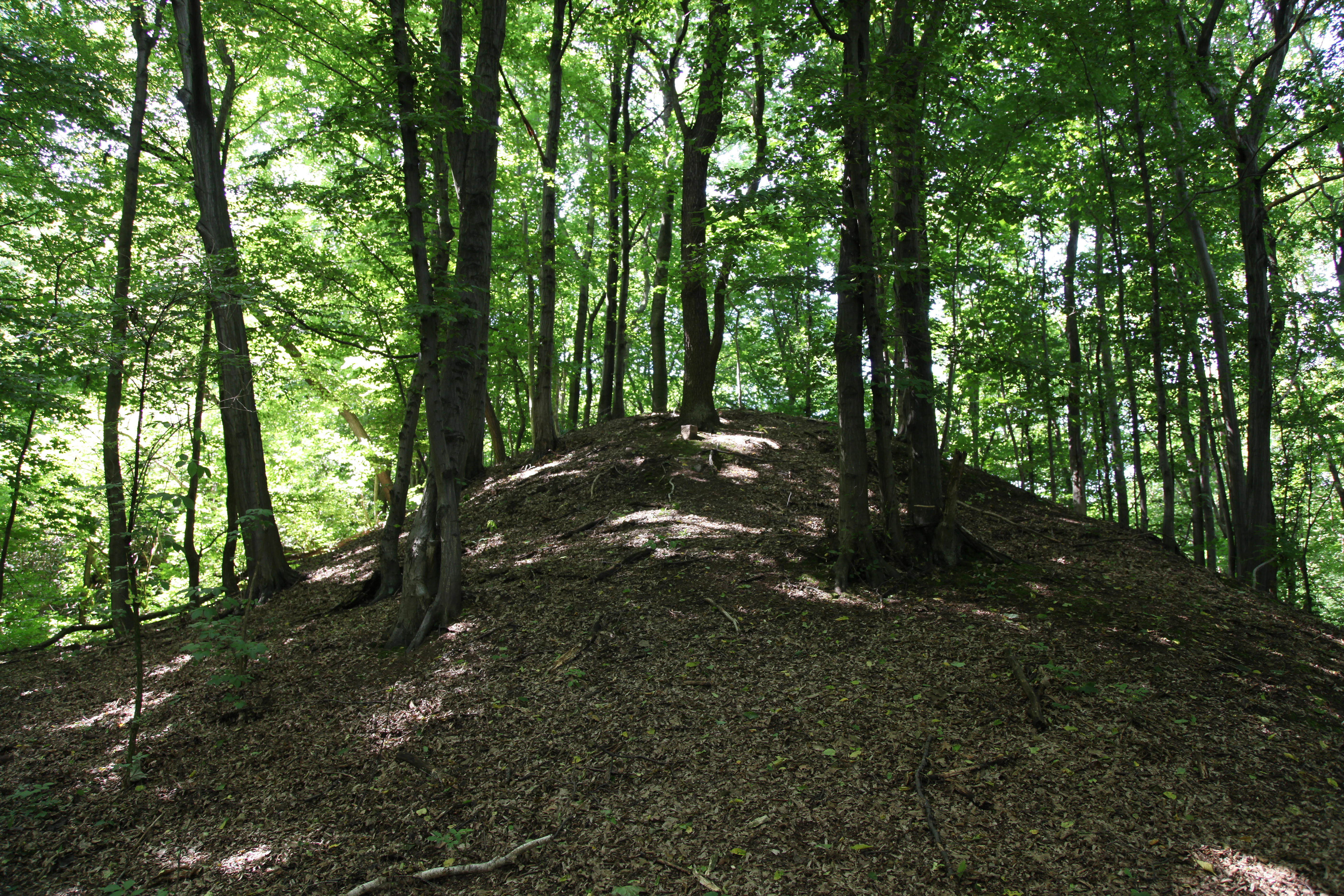
A gentle, leaf-covered earthen mound rises amidst a dense deciduous forest with dappled sunlight filtering through the canopy.
A forested mound at the historical site of Alte Schanze in Georgewitzer Skala.

Georgewitzer Skala ecosystems, habitats, and plant life

The ecological interest of Georgewitzer Skala rests on its combination of diverse near-natural deciduous forest communities with a natural stream habitat, all packed into a very small area. Forest cover dominates the reserve, and the tree composition shifts visibly from the waterside to the upper slopes. Near the stream, leaf-rich riparian strips of black alder form a narrow band along the watercourse, while the lower and middle slopes support linden-rich oak-hornbeam woodland with a strong hornbeam layer, grading further uphill into hornbeam-rich sessile oak-beech forest on better-drained positions. Below the woodland, a ground flora of characteristic spring and early-summer species thrives on the slightly base-rich soils created by the weathering granodiorite.

Soils derived from the local granodiorite are weakly alkaline in reaction, an unusual condition in this part of Saxony that supports a set of protected flowering plants including hollow corydalis, dark lungwort, lily of the valley, and greater stitchwort. The presence of these species, combined with the near-natural structure of the forest stands, is one of the main ecological arguments for the reserve's long-standing protected status. Together the woodland types, the rocky stream channel, and the loess-covered upland create a tight mosaic of microhabitats unusual for a protected area of this size.
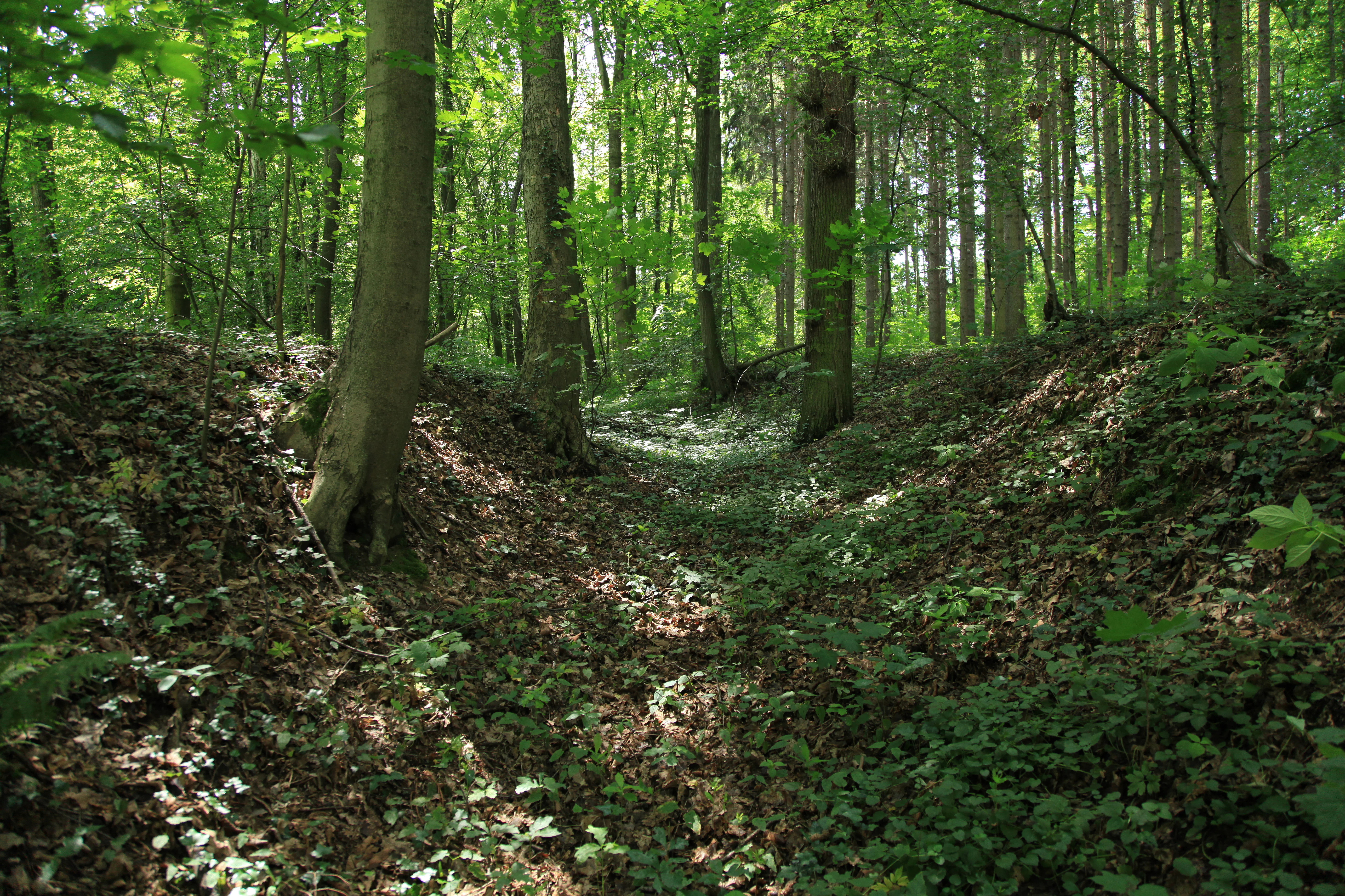
A view looking into a lush green forest with a natural depression or path lined by large tree trunks and ground cover.
A shaded forest path within the Georgewitzer Skala nature reserve.

Georgewitzer Skala wildlife and species highlights

The birdlife of the narrow valley is shaped by the combination of mature deciduous forest, rock faces, and a rocky, well-oxygenated stream. The most characteristic species include the kingfisher, which uses the steep bank sections of the Löbauer Wasser, the lesser spotted woodpecker, which depends on the older deciduous trees of the slope forests, and the grey wagtail, typically found along fast-flowing stony watercourses like the one running through the gorge. Their continued presence is treated as a useful indicator of the structural quality of the valley's habitats.

The watercourse itself, with its coarse, block-rich bed and natural flow regime, provides habitat for riverine invertebrates and small fish typical of small Upper Lusatian brooks, while the rock faces offer nesting and shelter sites for birds and small mammals that use cliff-like terrain. Mammals typical of mixed deciduous forest in the region, including common species such as red deer, roe deer, and wild boar, range throughout the wider landscape and use the reserve's forest cover as part of their range, although the reserve is most often discussed in terms of its woodland birds and its protected plant flora.

Georgewitzer Skala conservation status and protection priorities

Georgewitzer Skala has been a formally protected nature reserve since 1961, an unusually early designation in the regional context, reflecting the long-recognized conservation value of both its landform and its plant communities. Its protected status rests on two complementary pillars identified at the time of designation: its geomorphological character as a representative skala of the Oberlausitzer Gefilde, and the unusually intact state of its near-natural deciduous forest.

On the forest side, the reserve protects a compact but unusually full sequence of woodland types from alder riverside strips through oak-hornbeam to oak-beech forest, all on soils with weakly alkaline character derived from granodiorite weathering. That combination supports protected plant species such as hollow corydalis, dark lungwort, lily of the valley, and greater stitchwort, which would be hard to maintain in the surrounding agricultural landscape. On the geomorphological side, the reserve protects a representative reach of the Löbauer Wasser's granodiorite gorge, a landform under continuing pressure from any land-use changes in the surrounding catchment. The reserve's sharp forest-to-field boundary makes the protected forest easy to identify on the ground and helps maintain the contrast between enclosed woodland and open farmland that defines the valley's character.

Georgewitzer Skala cultural meaning and human context

The reserve carries a layered cultural heritage that ties it firmly to the Slavic and early German history of Upper Lusatia. At its core lies the Slavic section wall known as the Bielplatz, generally dated to around 1000 AD, which has been formally recognized as a cultural monument within the protected area. Close by, the strata antiqua, an ancient Saxon trade road linking Göda near Bautzen with Jauernick-Buschbach near Görlitz and continuing into Silesia, passed the valley and left behind the Alte Schanze earthwork, sometimes dated to around 1100, where merchants paid way tolls.

Below the village of Georgewitz, the medieval stone-built Gemauerte Mühle, first documented in 1425, anchors a more recent chapter of valley history. It was here that Field Marshal Blücher reportedly lodged in May 1813 during the wars against Napoleon, on his way through the area. The famous Rittersprung rock and its associated legend bring a folklore dimension to the valley's cultural identity. Together, these sites add a strong historical and narrative layer that complements the natural values of the reserve.

Top sights and standout views in Georgewitzer Skala

The principal highlights of Georgewitzer Skala are its compact granodiorite gorge, its diverse near-natural deciduous forest, and the historical features embedded directly within the protected valley. The reserve contains one of the more complete small-scale examples of a Lusatian skala, with rock faces, fissures, and a block-rich natural streambed along the Löbauer Wasser, framed by linden-rich oak-hornbeam and hornbeam-rich sessile oak-beech forest communities. Protected plant species such as hollow corydalis, dark lungwort, lily of the valley, and greater stitchwort grow on the slightly base-rich granodiorite soils, while kingfisher, lesser spotted woodpecker, and grey wagtail are among the characteristic woodland and waterside birds of the valley.

Beyond its natural assets, the reserve also contains the Slavic Bielplatz rampart, the Alte Schanze earthwork on the historic strata antiqua trade route, the medieval Gemauerte Mühle, and the legendary Rittersprung rock, all of which give the gorge a strong sense of historical depth within a very small spatial footprint.

Best time to visit Georgewitzer Skala

Spring is a particularly rewarding time to appreciate Georgewitzer Skala, when the ground flora of the slope forests, including protected species such as hollow corydalis and dark lungwort, comes into flower on the slightly alkaline granodiorite soils. Late spring and early summer also bring the characteristic leaf-out of the deciduous canopy and improved visibility along the valley before full summer foliage closes in the views. Autumn, with its leaf color on the oak, hornbeam, and beech dominated slopes, offers good conditions for general forest atmosphere, while winter, with bare branches, exposes the most striking geological features of the gorge, including its rock walls, fissures, and the block-strewn riverbed, with greater clarity than at other times of year.

Monthly climate preview

Track monthly temperature variations and precipitation averages across the protected terrain

Georgewitzer Skala Climate Normals and Long-Term Temperature Patterns

Measured coordinates reveal a steady progression of long-term temperature ranges alongside consistent precipitation metrics throughout the year. Reviewing the complete monthly profile provides deeper clarity on annual climate normals recorded at the representative station.
Annual mean8 °C
-2 °C19 °C
Jan-2°
Feb-1°
Mar
Apr
May13°
Jun17°
Jul19°
Aug19°
Sep14°
Oct
Nov
Dec-1°
Warmest month
July

18.8 °C

Coolest month
January

-2.5 °C

Wettest month
July

3 mm/day

Driest month
April

1.4 mm/day

Park location guide

Geography guide, regional context, and park location map for Georgewitzer Skala

Georgewitzer Skala park geography, regions, and map view in Germany

Understand where Georgewitzer Skala sits in Germany through a broader geographic reading of the surrounding landscape, nearby location context, and its mapped position within the national park landscape.

How Georgewitzer Skala fits into Germany

Germany is a federal republic in Western and Central Europe with a population of over 83 million across sixteen constituent states. It is Europe's largest economy by nominal GDP and a major global exporter and importer. The capital is Berlin, and the country borders Denmark, Poland, Czech Republic, Austria, Switzerland, France, Luxembourg, Belgium, and the Netherlands.

Wider geography shaping Georgewitzer Skala in Germany

Germany is located in Western and Central Europe, spanning 357,022 km². It borders Denmark to the north, Poland and the Czech Republic to the east, Austria and Switzerland to the south, and France, Luxembourg, Belgium, and the Netherlands to the west. The country has coastlines on the Baltic Sea and North Sea to the north, with the Alps located in the southern region.

Map view of Georgewitzer Skala

Use this park location map to pinpoint Georgewitzer Skala in Germany, understand its exact geographic position, and read its mapped placement within the surrounding landscape more clearly.

Pigeon | © OpenStreetMap contributors

Location context for Georgewitzer Skala

Landkreis Görlitz

Visualizing the granite gorge, deciduous forest, and protected valley habitats.

Georgewitzer Skala Photos and Landscape Scenery Exploration

Visual records capture the steep granodiorite rock faces, rocky stream channels, and forested ravine slopes that define Georgewitzer Skala. Examining field photography reveals the distinct terrain features, diverse forest communities, and protected natural character of this Upper Lusatian nature reserve.

A shallow, rocky stream winding through a dense, vibrant green forest, with a wooden footbridge visible on the bank.

A group of rustic stone and masonry buildings with red tile roofs situated in a green, wooded valley area.

A gentle, leaf-covered earthen mound rises amidst a dense deciduous forest with dappled sunlight filtering through the canopy.

A view looking into a lush green forest with a natural depression or path lined by large tree trunks and ground cover.

Park atlas

Compare surrounding rock gorges, river valleys, and forest reserves across Upper Lusatia.

Explore Parks Near Georgewitzer Skala and Related Protected Landscapes

Browse other protected areas near Georgewitzer Skala to uncover similar granodiorite gorges and wooded river valleys throughout the surrounding region. Comparing adjacent nature reserves provides deeper geographic context for the unique terrain and forest communities of eastern Saxony.
Watercolor illustration depicting a path through a green forest, with a pale meadow in the background.
Nature reserveSachsen
About 9.7 km away#1 closest

Northwest

Gröditzer Skala Nature Reserve: Geography and Protected Landscapes of the Upper Lusatian Region

A dense greywacke valley corridor in eastern Saxony

Centred on a narrow, rock-cut valley, Gröditzer Skala provides a dramatic display of geological features and botanical richness within the Landkreis Bautzen. This protected area, known for its steep slopes and diverse deciduous forest communities, offers a compact but highly varied terrain that remains a cornerstone of the regional natural heritage.

Area
0.39 km²
Established
1961
IUCN
IV
Relief
Upland
Nature reserveBautzen
About 17 km away#2 closest

Northwest

Spreeniederung Malschwitz Nature Reserve and Riverine Floodplain Geography

Protected riparian landscapes in the Bautzen district

Spreeniederung Malschwitz represents a significant protected floodplain along the Spree river. This nature reserve provides crucial habitats through its complex network of traditional fishponds, oxbow lakes, and old-growth forests, serving as a key staging site for migratory waterfowl within the Upper Lusatian landscape.

Area
18.57 km²
Established
2002
Natural monumentÚstí nad Labem Region
About 23 km away#3 closest

Southwest

Vlčice Natural Monument: Protected Acidophilic Beech Forest in the Ústí nad Labem Region

Mapped upland terrain and old-growth forest conservation

Vlčice represents a highly preserved fragment of old acidophilic beech forest in the northern Czech Republic. Characterized by its granodiorite geology and rolling upland terrain, the site provides a sanctuary for specialized forest species and serves as an important study area for natural woodland development within the broader Ústí nad Labem Region.

Area
0.273 km²
Established
2022
IUCN
IV
Relief
Upland
Watercolor illustration of rolling green hills, forests, and distant mountains
National parkCzechia
About 27 km away#4 closest

Southwest

Bohemian Switzerland National Park: Czech Sandstone Protected Landscape and Map Exploration

Discover its unique terrain and protected area geography.

Bohemian Switzerland National Park is a protected area in the Czech Republic known for its exceptional sandstone geology. This national park showcases a dramatic landscape of towering rock formations, deep gorges, and striking canyons, forming a significant part of the Elbe Sandstone Mountains. Through MoriAtlas, users can explore its mapped protected boundaries, understand its regional geographic context, and appreciate its unique natural heritage.

Area
79 km²
Established
2000
IUCN
II
Relief
Mixed relief
Watercolor painting showing a landscape with green hills, trees, and a river winding through the scene
National parkGermany
About 30 km away#5 closest

Southwest

Saxon Switzerland National Park: Protected Area Geography and Map Exploration

Discover its mapped boundaries and regional landscape context.

Saxon Switzerland National Park, a protected national park in Germany, offers a distinct focus for geographic and atlas-based discovery. This page details the park's specific protected landscape, its mapped boundaries, and its contribution to the regional geography. MoriAtlas allows for in-depth exploration of such natural areas, providing essential context for understanding their place within broader natural systems and mapped terrains.

Area
93.5 km²
Established
1990
IUCN
II
Visitors
1.7M annual
Watercolor painting of a green valley with a winding river and gentle mountains in the background, styled as a panoramic illustration.
Nature reserveSachsen
About 33 km away#6 closest

Southwest

Gimpelfang Nature Reserve: Mapped Forest Ecosystems and Protected Terrain in Sachsen

Ancient deciduous stands and brook-valley landscapes.

Gimpelfang is a ten-hectare nature reserve in the Saxon Switzerland district, notable for its mature broadleaf forest that escaped historical spruce planting. The site offers a window into regional ecology with its diverse brook-side ash and alder habitats and strictly protected total-reserve core, providing a dense, research-focused look at native woodland conservation in the German landscape.

Area
0.103 km²
Established
1961
IUCN
IV
A watercolor landscape illustration showing a winding river flowing through a lush green valley with distant hills.
Natural monumentÚstecký kraj
About 40 km away#7 closest

Southwest

Meandry Chřibské Kamenice: Geography of a Bohemian Natural Monument

Protected river meanders and sandstone valley terrain in northern Bohemia

Meandry Chřibské Kamenice serves as a vital protected area in the Czech Republic, specifically preserving the natural river dynamics of the Chřibská Kamenice stream. Its narrow floodplain, characterized by evolving meanders, riparian woodland, and marshy habitats, offers a focused look at how watercourses shape the sandstone landscapes of the Ústecký kraj region.

Area
0.085 km²
Established
1996
IUCN
III
Relief
Lowland
Natural monumentÚstecký kraj
About 42 km away#8 closest

Southwest

Sojčí rokle Natural Monument: Atlas and Geography of the Ústecký kraj Sandstone Gorge

A protected ravine sanctuary within the Bohemian Switzerland landscape region.

The Sojčí rokle natural monument features a deep, moist sandstone gorge that sustains a specialized microclimate. Located near Janská in the Ústecký kraj, the site serves as a vital ecological corridor with unique oak-hornbeam forests and rare plant life, representing the intricate rock-carved geography that defines the wider protected landscape of northern Bohemia.

Area
0.035 km²
Established
2016
IUCN
IV
Relief
Upland

Common questions about visiting, size, designation, and location context for Georgewitzer Skala

Georgewitzer Skala FAQs for park facts, access, geography, and protected area context

Find quick answers about Georgewitzer Skala, including protected-area facts, park geography, trail and visitor context, and how the park fits into its surrounding country and regional landscape.
MoriAtlas Explorer

Continue Your Protected Areas Search Across the Global Atlas

Deepen your exploration by continuing the structured search for national parks and protected areas worldwide. Utilize the comprehensive filtering capabilities to compare different conservation landscapes and refine your understanding of global park geography. Discover more about the distribution and characteristics of protected natural areas.

Global natural geography