Mori Atlas logo
Marine protected areaGifford Marine Park

Exploring the underwater topography and seamount-driven marine geography of the Tasman Sea

Gifford Marine Park and the Lord Howe Seamount Chain: Deep Ocean Protected Area Mapping

Gifford Marine Park protects a distinct underwater landscape located 700 kilometres off the coast of Queensland. The park encompasses two large guyots, or flat-topped seamounts, which rise steeply from the abyssal plain to influence local current patterns and nutrient cycles. This offshore reserve serves as a critical reference point for the Temperate East Marine Park Network, providing protected space for migratory whales and deep-sea pelagic habitats.

marine parkseamountguyotoffshore reserveTasman SeaLord Howe Seamount Chain

Gifford Marine Park

Marine protected area

Park overview

Structured park overview, official facts, and landscape profile for Gifford Marine Park

Gifford Marine Park park facts, protected area profile, and essential visitor context

Review the core facts for Gifford Marine Park, including designation, size, terrain, visitor scale, habitats, and operating context in one park-focused overview.

About Gifford Marine Park

Gifford Marine Park is one of Australia's most geographically remote marine protected areas. Positioned around 700 kilometres east of Brisbane, it lies in deep oceanic waters that are far from any coastline and have little visual presence above the surface. Its significance lies entirely below the waterline, in the submerged landscape of two ancient seamounts that rise from the surrounding abyssal depths.

These seamounts are part of the Lord Howe Seamount Chain, a string of geological structures that extends across a wide section of the Tasman Sea. The park protects the waters immediately surrounding the two summits known as Gifford Guyot and its neighbour, encompassing their steep flanks and the pelagic waters that pass over them. Guyots are flat-topped seamounts, typically formed by volcanic activity and later flattened over geological time, and they create distinctive ecological conditions because their elevated seafloor intercepts currents and supports complex habitat structure within an otherwise deep and uniform ocean environment.

The park forms one component of the Temperate East Marine Park Network, a coordinated system of Australian Commonwealth marine reserves that share planning arrangements across the temperate waters stretching along the eastern and southeastern margins of the continent. Within this broader network, Gifford is notable for its focus on a seamount ecosystem rather than coastal reef, continental shelf, or island habitats. The combination of offshore isolation, geological uniqueness, and biological productivity justifies its position as a separately managed reserve.

The marine park is managed as a Habitat Protection Zone under the IUCN Category IV framework, signalling that the primary conservation objective is the maintenance and recovery of habitat condition rather than a complete prohibition of all activities. This zoning reflects the broader Australian approach of using multiple management categories within its marine park system to balance protection with compatible uses.

Quick facts and research context for Gifford Marine Park

Gifford Marine Park is an offshore Commonwealth marine reserve situated east of the southern Queensland coast, well beyond the continental shelf. It belongs to the Temperate East Marine Park Network, a grouping of Australian marine parks that share administrative and ecological planning frameworks across the temperate waters of the western Tasman Sea.

The park's geography is dominated by two seamounts on the Lord Howe Seamount Chain, one of which, Gifford Guyot, lends its name to the protected area. The park is managed as a Habitat Protection Zone, recognised internationally under IUCN Category IV, which reflects an emphasis on safeguarding natural habitat conditions rather than restricting all human activity.

Protection and recognition

Documented marine area protection details and designation history

Gifford Marine Park Protection Status and Management Scope

Gifford Marine Park maintains a documented marine protection scope and defined conservation boundaries within the regional network. Recorded designation data and international recognition frameworks establish the baseline administrative profile for this marine protected area.

Protection details

Protection scope
Marine
Transboundary protection
No
Park context

Deeper park guide and search-rich context for Gifford Marine Park

Gifford Marine Park history, landscape, wildlife, and travel context

Explore Gifford Marine Park through its history, landscape character, ecosystems, wildlife, conservation priorities, cultural context, and seasonal travel timing in a structured park guide built for atlas discovery and search intent.

Why Gifford Marine Park stands out

Gifford Marine Park is best known for the two flat-topped seamounts, or guyots, that it encircles within the Lord Howe Seamount Chain. These ancient volcanic formations rise steeply from the deep seafloor and create a rare shallow and mid-depth environment in an otherwise very deep oceanic setting. The park is also recognised for its potential role in supporting large migratory whales, including humpback and sperm whales, which use the seamount environment for feeding, resting, breeding, and as navigational reference points. This combination of distinctive geology and marine megafauna presence gives the park a clearly defined identity among Australia's offshore marine reserves.
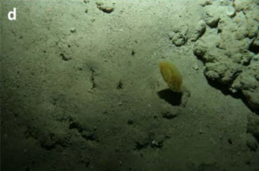
Underwater view of a sandy seafloor with a limestone rock formation on the right and a small, solitary yellow sea squirt in the center.
A yellow ascidian attached to a limestone outcropping on the seafloor of Gifford Marine Park.

Gifford Marine Park history and protected-area timeline

Gifford Marine Park was established as part of Australia's Commonwealth marine reserves program under the federal framework that created a coordinated network of offshore marine parks across the country's exclusive economic zone. Its inclusion in the Temperate East Marine Park Network places it within a system designed to represent the different marine environments of southeastern Australia through area-based protection.

The park's identification and establishment were closely tied to recognition of the ecological importance of the Lord Howe Seamount Chain and its individual seamount features. The seamount that ultimately gave the park its name, Gifford Guyot, had been mapped and studied as part of broader geological and oceanographic research into the submerged landscape east of Australia, and its conservation significance was reinforced by observations of large marine species, including humpback and sperm whales, moving through and around the area.

Following its designation, the park was assigned a Habitat Protection Zone status under the international IUCN protected area framework, a management classification that reflects an emphasis on conserving habitat quality rather than imposing the strictest level of reserve protection. This classification is consistent with the broader marine park zoning approach used across Australia's temperate east reserves.

Gifford Marine Park landscape and geographic character

The landscape of Gifford Marine Park is wholly submarine. There are no islands, reefs breaking the surface, or coastlines within or near the park. Instead, its geography is defined by the seafloor topography, particularly the sudden vertical presence of two seamounts rising out of a deep and otherwise relatively flat abyssal plain.

Gifford Guyot, the larger and namesake feature, is a flat-topped underwater mountain with steep sides, characteristic of guyot landforms shaped by long periods of subsidence and erosion. Its summit lies at a shallower depth than the surrounding seafloor, creating a localised high-relief environment in waters that would otherwise be extremely deep. The second seamount included within the park shares a similar profile and, together with Gifford Guyot, forms a paired geological feature along the Lord Howe Seamount Chain.

These structures profoundly influence the local marine landscape. As ocean currents encounter the seamounts, they can be deflected, accelerated, and mixed, producing upwellings and changes in water temperature and nutrient distribution. The resulting conditions differentiate the area from surrounding deep-sea environments and contribute to its ecological character, even though the dramatic physical shaping is invisible from above the waterline.

Gifford Marine Park ecosystems, habitats, and plant life

Ecologically, Gifford Marine Park represents a seamount habitat type rather than the more familiar coastal reef, shelf, or pelagic ecosystems that dominate many other Australian marine reserves. Seamounts are recognised globally as biodiversity hotspots within the open ocean because their elevated and structurally complex seafloor supports richer biological communities than the soft, sediment-covered abyssal plains around them.

The flanks and summits of the two guyots within the park provide hard substrate where sponges, corals, and other sessile invertebrates can attach, in contrast to the muddy sediments typical of the deeper surrounding seafloor. These biological aggregations in turn attract a variety of mobile species, including fishes and invertebrates that use the seamount structures for shelter and feeding.

Because the seamounts rise into the water column at depths that intersect with the normal ranges of large pelagic species, the park also supports a broader oceanic ecosystem above the seafloor. The interaction between the benthic environment of the guyots and the overlying water column gives the park a layered ecological structure, combining seafloor communities with the open-water habitat of the Tasman Sea.

Gifford Marine Park wildlife and species highlights

The wildlife profile of Gifford Marine Park is strongly shaped by the presence of the seamounts and their interaction with the wider ocean environment. The park is recognised as habitat for large marine species, particularly humpback whales and sperm whales, which are known to use areas around seamounts for rest, feeding, navigation, and in some cases breeding.

The seafloor communities associated with the guyots themselves support a range of invertebrate life adapted to hard substrates, including sponges and cold-water coral species typical of seamount environments in the region. These slow-growing, habitat-forming organisms contribute to the overall biodiversity of the park by providing structure that other marine animals rely on.

In the waters above the seamounts, the park overlaps with the migratory pathways of pelagic species, including tunas, billfishes, and other open-ocean swimmers that pass through the Tasman Sea. Although the park is not characterised by coastal or reef-associated species, the combination of benthic seamount communities and pelagic visitors gives it a distinctive place within Australia's offshore marine biodiversity estate.

Gifford Marine Park conservation status and protection priorities

Gifford Marine Park's conservation value lies in its protection of a relatively rare deep-sea habitat type within Australian waters. Seamount ecosystems are considered ecologically important because of their ability to concentrate biodiversity and biomass in otherwise resource-poor deep ocean environments, and protecting multiple seamounts within a single park strengthens the representation of this habitat type in Australia's marine reserve system.

The park's designation as a Habitat Protection Zone under IUCN Category IV emphasises the safeguarding of habitat quality and natural ecological processes, including the preservation of the seafloor structure and the biological communities it supports. This zoning allows some compatible activities to continue while limiting activities that could damage benthic habitats or significantly alter the marine environment.

As part of the larger Temperate East Marine Park Network, Gifford also contributes to broader conservation objectives such as the resilience of marine ecosystems to pressures including climate change, ocean acidification, and extractive uses. By protecting an offshore seamount system far from the coast, the park adds ecological depth and geographic spread to Australia's overall marine conservation estate.

Gifford Marine Park cultural meaning and human context

Because Gifford Marine Park lies far from any populated coastline and contains no land above the ocean surface, it does not have an associated onshore human settlement or community. Its cultural context is therefore primarily scientific and oceanic rather than based on local human heritage.

The name "Gifford" reflects the standard practice of naming seamounts and associated marine features in the Lord Howe Seamount Chain after geographic or scientific references, and the park borrows this nomenclature to identify its geographic focus. The conservation of this area can be understood as part of a wider cultural recognition that offshore, unseen environments also warrant formal protection, even when they are not visible or accessible to the general public.

Top sights and standout views in Gifford Marine Park

Gifford Marine Park stands out for protecting two of the seamounts of the Lord Howe Seamount Chain, including the namesake Gifford Guyot, in an offshore setting roughly 700 kilometres east of Brisbane. Its habitat protection status emphasises the maintenance of ecological conditions around these geological features rather than a strict no-activity regime, consistent with its role in the Temperate East Marine Park Network.

The park's combination of rare seamount habitat, presence of humpback and sperm whales, and remote Tasman Sea location makes it one of the more distinctive elements of Australia's offshore marine reserve system and a useful reference point for understanding how Australia protects deep, non-coastal ocean environments.

Best time to visit Gifford Marine Park

Gifford Marine Park is a remote offshore marine protected area with no land access or visitor facilities, so conventional "best time to visit" considerations based on weather, tourist seasons, or accessibility do not apply in the way they would for a land-based national park. The park is primarily relevant to researchers, commercial operators working under permit, and those engaged in offshore marine science rather than general tourism.

For those interested in the broader region or ecosystem, conditions in the Tasman Sea east of southern Queensland are strongly influenced by seasonal weather patterns, with calmer ocean conditions generally associated with the late spring to early autumn months. However, any on-water presence in or near the park would depend on vessel capability, permits, and regulatory requirements rather than seasonal visitor timing.

Monthly climate preview

Long-term representative measurements showing monthly temperature and precipitation cycles

Gifford Marine Park Climate Normals, Annual Temperature and Precipitation Rhythm

Historical data records the annual temperature and precipitation rhythm across representative coordinates within Gifford Marine Park. Examining the complete monthly climate normals reveals detailed seasonal variations in long-term averages.
Annual mean22 °C
19 °C25 °C
Jan24°
Feb25°
Mar24°
Apr23°
May22°
Jun21°
Jul20°
Aug19°
Sep20°
Oct20°
Nov22°
Dec23°
Warmest month
February

24.7 °C

Coolest month
August

19.1 °C

Wettest month
February

3.1 mm/day

Driest month
September

1 mm/day

Park location guide

Geography guide, regional context, and park location map for Gifford Marine Park

Gifford Marine Park park geography, regions, and map view in Australia

Understand where Gifford Marine Park sits in Australia through a broader geographic reading of the surrounding landscape, nearby location context, and its mapped position within the national park landscape.

How Gifford Marine Park fits into Australia

Australia is a constitutional monarchy and federal parliamentary democracy comprising six states and ten territories. With a population of nearly 28 million, it is one of the world's most urbanised countries, with most people concentrated on the eastern seaboard. The country has a high Human Development Index and is known for its cultural diversity, ancient Aboriginal heritage, and unique wildlife.

Wider geography shaping Gifford Marine Park in Australia

Australia occupies the entire Australian continent, the island of Tasmania, and numerous smaller islands. It is the world's flattest and driest inhabited continent, featuring vast deserts in the interior (the Outback), tropical rainforests along the eastern coast, and a coastline bordering the Indian and Pacific Oceans.

Map view of Gifford Marine Park

Use this park location map to pinpoint Gifford Marine Park in Australia, understand its exact geographic position, and read its mapped placement within the surrounding landscape more clearly.

Pigeon | © OpenStreetMap contributors

Location context for Gifford Marine Park

Queensland

Visual exploration of deep oceanic habitats and submerged guyot terrain

Gifford Marine Park Photos and Seamount Landscape Scenery

Visual documentation of Gifford Marine Park reveals the submerged topography and unique oceanic environment of the Lord Howe Seamount Chain. Examining these offshore marine habitats clarifies how ancient volcanic formations and pelagic waters shape the protected ecosystem.

Underwater view of a sandy seafloor with a limestone rock formation on the right and a small, solitary yellow sea squirt in the center.

An underwater photograph showing a textured limestone ridge on the ocean floor, characterized by greenish sediment, small sponges, and a small fish.

Park atlas

Compare adjacent marine protected areas and regional ocean geography

Exploring Other Parks Near Gifford Marine Park and Surrounding Offshore Reserves

Browse related protected areas and regional ocean reserves to compare unique seafloor topography and marine habitats. Extending the exploration beyond Gifford Marine Park provides valuable context for understanding offshore conservation networks.
A horizontal watercolor painting showing a soft, hazy view of coastal hills and islands against a pale sky.
Marine protected areaNew South Wales
About 488 km away#1 closest

South

Lord Howe Island Marine Park: Mapping the Southernmost Coral Reefs of New South Wales

A comprehensive marine protected area featuring barrier reefs and volcanic island topography.

Lord Howe Island Marine Park protects a rare marine environment defined by its position at the latitudinal limit of reef growth. Encompassing barrier reefs, lagoons, and rocky island coasts, this protected area serves as a critical habitat for endemic marine life influenced by the East Australian Current. Explore the complex underwater terrain and geographic boundaries that define this landmark marine reserve in the Tasman Sea.

Area
465.45 km²
Established
1999
IUCN
II
Relief
Lowland
Marine protected areaNew South Wales
About 539 km away#2 closest

Southwest

Central Eastern Marine Park: A Guide to Australia's Deep Ocean and Seamount Landscapes

Geographic analysis of seafloor canyons and marine ecosystems

Covering a vast expanse of the Pacific, Central Eastern Marine Park serves as a critical conservation zone for varied submerged terrain. From the shelf-incising canyons off New South Wales to the isolated guyots of the Tasmantid Seamount Chain, this park offers a comprehensive look at the geological features influencing eastern Australian marine life.

Area
70,054 km²
Established
2018
IUCN
IV
Relief
Mixed relief
Marine protected areaNew South Wales
About 544 km away#3 closest

South

Lord Howe Marine Park: Geographic Profile and Protected Marine Landscape Assessment

Mapping offshore seamounts and reef systems in the Tasman Sea.

Lord Howe Marine Park stands as a major protected area within Australian Commonwealth waters, defined by its immense scale and complex underwater topography. The park guards unique seafloor structures including ridges, plateaus, and the isolated reef environments of the Elizabeth and Middleton Reefs. This geographic overview highlights the park's role as a biological convergence zone where oceanic currents drive nutrient cycles and sustain significant seabird colonies and cetacean migration paths.

Area
110,126 km²
Established
2018
IUCN
IV
Relief
Lowland
National parkQueensland
559 km away#4 closest

West

Naree Budjong Djara National Park: Queensland National Park with Mapped Boundaries

Explore its protected landscape geography and regional context.

Naree Budjong Djara National Park represents a vital protected area within Queensland, Australia, offering a distinct national park experience. This profile details its geographic scope and mapped features, contributing to a comprehensive understanding of Queensland's protected lands. Engage with its landscape context for structured atlas exploration and a clearer view of its natural terrain.

Area
132.24 km²
Established
2011
IUCN
II
Climate
Subtropical
A soft watercolor painting of a landscape featuring rolling green hills, a faint mountain range in the distance, and sparse vegetation in the foreground.
Nature reserveNew South Wales
About 562 km away#5 closest

West

Cook Island Nature Reserve: Coastal Protected Landscapes and Island Geography in New South Wales

Strictly protected island terrain and offshore seabird refuge.

Cook Island Nature Reserve represents a specialized five-hectare island protected area off the northern New South Wales coastline. This offshore site functions as a vital nature reserve, characterized by its preserved scrub vegetation and role as a high-value habitat for breeding seabirds. Its geographic isolation and strict conservation focus offer a defined landscape contrast to the adjacent mainland coastal environments.

Area
0.05 km²
Established
1959
IUCN
Ia
Relief
Lowland
A soft watercolor painting depicting a coastal landscape with a green island in the middle ground and a pale sky above.
Marine protected areaNew South Wales
About 562 km away#6 closest

West

Cook Island Aquatic Reserve: Marine Protected Area and Coastal Geography Overview

Mapped marine landscapes on the New South Wales coast.

Cook Island Aquatic Reserve features a compact but ecologically rich seascape surrounding a rocky island near Fingal Head. This marine protected area demonstrates a precise zoned management strategy, preserving critical shark habitats and varied reef communities at the intersection of tropical and temperate maritime zones.

Area
0.74 km²
Established
1998
Relief
Lowland
Climate
Subtropical
Marine protected areaNew South Wales
About 564 km away#7 closest

West

Cape Byron Marine Park: Protected Marine Geography and Coastal Landscapes in New South Wales

Subtropical marine sanctuary and reef biodiversity atlas

Spanning from the Brunswick River to Lennox Head, Cape Byron Marine Park serves as a vital protected area on the Australian east coast. Analyze its coastal geography, including tidal estuaries, sandy surf beaches, and significant submerged reef structures that support a convergence of subtropical and temperate marine life.

Area
220 km²
Established
2002
Relief
Lowland
Climate
Subtropical
Nature reserveNew South Wales
About 564 km away#8 closest

West

Ukerabagh Island Nature Reserve: Mapped Geography and Protected Estuarine Landscapes

Coastal river island habitat in Northern New South Wales

Ukerabagh Island Nature Reserve offers a distinct look at tidal estuarine environments and coastal vegetation. This 125 hectare protected area acts as a sanctuary for bird populations and preserves remnant littoral rainforests within the lower Tweed River, providing a clear view into the ecological character of this southeastern Australian coastal region.

Area
1.25 km²
Established
1983
IUCN
Ia
Relief
Lowland

Common questions about visiting, size, designation, and location context for Gifford Marine Park

Gifford Marine Park FAQs for park facts, access, geography, and protected area context

Find quick answers about Gifford Marine Park, including protected-area facts, park geography, trail and visitor context, and how the park fits into its surrounding country and regional landscape.
MoriAtlas Explorer

Continue Your Protected Areas Search Across the Global Atlas

Deepen your exploration by continuing the structured search for national parks and protected areas worldwide. Utilize the comprehensive filtering capabilities to compare different conservation landscapes and refine your understanding of global park geography. Discover more about the distribution and characteristics of protected natural areas.

Global natural geography