Peaks
Shadow Peak
3,261 m

Technical overview of protected terrain, mountain ranges, and regional boundaries.
Examine the detailed geographic structure of Grand Teton National Park, encompassing 1300 square kilometers of mountainous terrain in Wyoming. This profile outlines elevation metrics ranging from 1940 meters to 4199 meters and categorizes the park's diverse alpine meadows, coniferous forests, and glacial features.
Related tags
Dramatic alpine peaks rising above a pristine valley in northwestern Wyoming
Grand Teton National Park protects a spectacular portion of the Teton Range and the northern Jackson Hole valley in northwestern Wyoming. The park encompasses approximately 310,000 acres of mountainous terrain, including Grand Teton, the tallest peak in the range at 13,775 feet, which rises more than 7,000 feet above the valley floor. The park is situated immediately south of Yellowstone National Park, to which it is connected by the John D. Rockefeller Jr. Memorial Parkway, and together with surrounding national forests these protected areas form the Greater Yellowstone Ecosystem, one of the world's largest intact mid-latitude temperate ecosystems. The park contains over 100 alpine lakes, the largest being 15-mile-long Jackson Lake, and the upper main stem of the Snake River winds through the valley. The Teton Range is the youngest in the Rocky Mountains, having formed between 6 and 9 million years ago as a dramatic fault-block mountain front rising abruptly from the valley without foothills. Some of the oldest rocks found in any American national park, nearly 2.7 billion years old, are exposed in the range.
Administrative distribution in Teton County and the United States
Tracing a protected conservation wilderness covering 1,300 square kilometers
Vertical range summary and recorded named natural features within the park
Peaks
3,261 m
Peaks
3,572 m
Peaks
3,767 m
Forests
2,072 m
Lakes
Forests
Temperate climate zones, mountain relief, and major water features across park geography
Mountains · Valleys · Cliffs · Forest · Grassland · Wetland · Lakes · Rivers · Waterfalls · Glacier · Canyon · Hills
Tundra habitat · Alpine meadow · Montane forest · Temperate coniferous forest · Temperate broadleaf forest · Grassland · Shrubland · Wetland · Riverine habitat · Lacustrine habitat · Glacial habitat
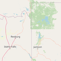
Trace regional park geography and connected protected landscapes within the iconic Greater Yellowstone Ecosystem for broader context.
Northwest

Glacially sculpted high-country basins in western Wyoming
Spanning the western face of the Teton Range, the Jedediah Smith Wilderness serves as a federally protected buffer for iconic mountain landscapes. The region features dramatic cirques, hanging valleys, and dense subalpine forest habitats, forming an essential, roadless link within the broader Greater Yellowstone Ecosystem. Explore the terrain features and structural geography that define this remote high-country wilderness area.
North
Explore mapped boundaries and regional natural landscape context.
Yellowstone National Park represents a significant protected landscape within Wyoming, designated as a US national park. This entry offers detailed insight into its geographic scope, mapped boundaries, and the unique natural terrain that defines it. Understand its role in regional geography and discover its protected-area identity through a structured atlas exploration, providing context for its conservation landscape.

Northeast
Rugged wilderness and glacial peaks in Wyoming
Discover the immense geographic scale of Shoshone National Forest, which protects a diverse landscape ranging from sagebrush valleys to 13,000-foot granite summits. This atlas overview details its role within the Greater Yellowstone Ecosystem and its expansive, federally designated wilderness areas, offering a clear perspective on its volcanic and glacial terrain.
Southeast
A core alpine environment within the Wind River Range.
Fitzpatrick Wilderness represents one of the most uncompromisingly wild segments of the Wind River Range, featuring persistent glaciers, dramatic U-shaped valleys, and high granite spires. This protected landscape offers a deep look into the alpine geography of Wyoming, preserved under the Wilderness Act to maintain its rugged character, remote glacial cirques, and intricate mountain ecosystems.
Northwest
High elevation marshes and protected water basins.
Red Rock Lakes Wilderness preserves an extensive high-elevation wetland complex in Beaverhead County, Montana. This nature reserve, characterized by shallow lake basins and forested mountain ridges, serves as a vital ecological corridor in the Northern Rockies. Its protected landscape offers a study in water-driven geography, where remote marshes and reflective lakes define the terrain's character.
North
Mapping rugged alpine terrain across four distinct mountainous units
Located in southwestern Montana, the Lee Metcalf Wilderness serves as a cornerstone of ecological connectivity within the Greater Yellowstone Ecosystem. Spanning over 250,000 acres, this protected area features a unique fragmented geography consisting of the Bear Trap Canyon, Spanish Peaks, Taylor-Hilgard, and Monument Mountains units. The landscape is defined by its roadless mountain ridges, forested slopes, and deep river corridors, providing essential sanctuary for large mammal populations.
Southeast
High-altitude alpine terrain and glacial basins
The Popo Agie Wilderness in Wyoming encompasses a dramatic vertical landscape, ranging from forested valleys to alpine summits above 13,000 feet. This protected area features the iconic Cirque of the Towers, dense hydrological networks of glacial tarns, and expansive granite formations that anchor its identity within the Greater Yellowstone Ecosystem.

Northwest
Extensive alpine ridges and wild river corridors
Spanning over 4.2 million acres, Salmon, Challis National Forest is a foundational protected landscape in Idaho. This area includes the highest peaks in the state, such as Borah Peak, and holds the majority of the Frank Church, River of No Return Wilderness. Utilize this atlas resource to examine the intricate mountain topography, expansive river systems, and the contiguous wild corridors that define this significant portion of the northern Rockies.
Deepen your understanding of Grand Teton National Park by exploring its specific mapped boundaries and the surrounding regional geography. This focused exploration provides essential context for comprehending its protected landscape identity and its role within the atlas of North American natural areas. Uncover the detailed geographic features that define this important national park.