
Cliffs
Park geography
Mapped boundaries, terrain elevation, and coastal landscape characteristics
Geographic Profile of Gwaii Haanas National Park Reserve and Haida Heritage Site
Examine the physical geography and structured dimensions of Gwaii Haanas National Park Reserve and Haida Heritage Site in British Columbia. This profile details the recorded 1470 square kilometer area, maximum elevations reaching 1100 meters, and a diverse terrain encompassing coastal cliffs, islands, and temperate forest ecosystems.
Related tags
Temperate RainforestMarine ConservationIndigenous HeritageCoastal IslandsPacific Northwest
Islands of Beauty: A Haida-managed protected archipelago spanning mountain to ocean
Gwaii Haanas National Park Reserve and Haida Heritage Site
Gwaii Haanas is a remarkable protected archipelago in southern Haida Gwaii, British Columbia, Canada, located approximately 130 kilometres off the mainland coast. The reserve encompasses 138 islands, with Moresby Island being the largest and Kunghit Island marking the southernmost point. The name Gwaii Haanas, meaning "Islands of Beauty" in the Haida language, reflects the profound spiritual and cultural significance this landscape holds for the Haida people, who have inhabited these islands for at least 14,000 years. This exceptional protected area is managed cooperatively by the Haida Nation and the Government of Canada through the Archipelago Management Board, representing one of the few places in the world where a representative area is protected from mountain top to ocean depth, combining terrestrial and marine conservation within a unified framework.
- Location
- Canada
- Park type
- National park
- Established
- 1988
- Area
- 1,470 km²
- Highest point
- 1,100 m
Location overview
Island and coastal geography within British Columbia, Canada
Geography of Gwaii Haanas National Park Reserve and Haida Heritage Site
Gwaii Haanas National Park Reserve and Haida Heritage Site lies in Canada within British Columbia and Haida Gwaii. Registered geographic facts classify the reserve as both an island park and a coastal park.
- Countries
- Canada
- Regions
- British Columbia, Haida Gwaii
- Primary location
- Haida Gwaii
- Geographic setting
- Coastal · Island
Boundary and coordinates
Explore spatial dimensions and the 1470 square kilometer footprint
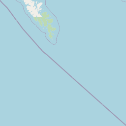
Gwaii Haanas National Park Reserve Boundary Map and Geographic Limits
Interactive boundary geometry outlines the spatial extent of Gwaii Haanas National Park Reserve and Haida Heritage Site. Recorded area metrics, center coordinates, and geographic spans clarify the physical dimension of the protected landscape.
- Boundary area
- 1,286.2 km²
- Boundary perimeter
- 1,306.5 km
- Northernmost point
- 52.8101° N
- Southernmost point
- 51.9418° N
- Easternmost point
- 130.9365° W
- Westernmost point
- 132.1088° W
- Geographic centre
- 52.4226° N, 131.4702° W
- North–south span
- 96.6 km
- East–west span
- 79.8 km
Elevation and terrain
Mountain relief metrics and recorded coastal and marine natural features
Gwaii Haanas National Park Reserve and Haida Heritage Site Terrain and Elevation
Recorded elevation records place the highest point at 1100 meters within a mountain relief classification. Linked feature cards supply names, types, and spatial relationships for recorded natural features.
- Maximum elevation
- 1,100 m
- Highest point
- 1,100 m
Selected named natural features
Cliffs
Gaowina Point
Cliffs
Forsyth Point
Capes
Tuga Point
Lakes
Upper Victoria Lake
Bays
Soulsby Cove
Environmental setting
Temperate climate zones, dominant forest cover, and coastal mountain relief classifications
Gwaii Haanas National Park Reserve and Haida Heritage Site Environmental Settings
Recorded landscape features and habitat types serve as interpretive categories for the physical setting of Gwaii Haanas National Park Reserve and Haida Heritage Site. Stored environmental classifications connect directly to relevant atlas destinations across the protected area.
- Relief
- Mountain
- Climate
- Temperate
- Water
- Major water bodies
- Forest cover
- Dense forest cover
Landscape features
Cliffs · Coast · Forest · Hills · Islands · Lakes · Mountains · Rivers · Tundra · Valleys · Wetland
Habitat types
Alpine meadow · Coastal habitat · Temperate coniferous forest · Tundra habitat · Wetland
Park atlas
Trace the regional park geography of British Columbia and the Pacific Northwest, comparing coastal islands, temperate rainforests, and marine protected areas.
Discover Other National Parks and Protected Areas Near Gwaii Haanas National Park Reserve and Haida Heritage Site
After exploring Gwaii Haanas National Park Reserve and Haida Heritage Site, delve into a broader collection of national parks and protected areas across the Pacific Northwest, including other coastal islands and temperate rainforest regions. This geographic overview allows you to compare diverse conservation landscapes, map regional protected-area spread, and understand the varied ecosystems of British Columbia.
Protected landscapeBritish Columbia
76 km away#1 closest
Northwest

Duu Guusd Heritage Site/Conservancy: Coastal Geography and Protected Land Map
A unified land and sea protected landscape in Haida Gwaii, British Columbia
Spanning over 227,000 hectares, Duu Guusd Heritage Site/Conservancy creates a massive protected corridor along the Pacific coast of British Columbia. This area links terrestrial forest ecosystems with marine waters, preserving complex island landscapes and significant Haida cultural sites throughout the northwestern corner of Graham Island.
- Area
- 2,277.12 km²
- Established
- 2008
- IUCN
- II
- Relief
- Mixed relief
State or regional parkBritish Columbia
About 158 km away#2 closest
Northeast
Klewnuggit Inlet Marine Provincial Park: Regional Geography and Protected Area Mapping
Coastal inlet, freshwater lakes, and northern forest ecosystems.
Klewnuggit Inlet Marine Provincial Park showcases the dramatic meeting of mountain, forest, and sea. Spanning from the sheltered waters of the Grenville Channel to inland freshwater systems, the park offers a detailed study of northern coastal geography, fjord-like marine channels, and diverse bird and marine wildlife habitats.
- Area
- 18 km²
- Established
- 1993
- IUCN
- II
- Relief
- Mixed relief
Marine protected areaBritish Columbia
About 176 km away#3 closest
North
Kitson Island Marine Provincial Park Map and Coastal Protected Area Atlas
Protected island and estuarine landscape in British Columbia
Kitson Island Marine Provincial Park encompasses a vital coastal island and the adjacent Flora Bank at the mouth of the Skeena River. This protected marine environment provides a rare example of accessible sandy beach terrain on the North Coast. Use this atlas resource to understand the park boundaries, island geography, and estuarine interface within the broader Inside Passage conservation network.
- Area
- 0.45 km²
- Established
- 1993
- IUCN
- II
- Relief
- Lowland
State or regional parkBritish Columbia
About 186 km away#4 closest
Northeast
Diana Lake Provincial Park: Mapping Coastal Rainforest and Wetland Geography in British Columbia
An examination of North Coast forest and freshwater ecosystems
Diana Lake Provincial Park represents a significant protected area in British Columbia, showcasing the diverse ecological character of the North Coast. The park boundary encompasses a mosaic of old-growth rainforest, open blanket bogs, and freshwater aquatic systems. By protecting these varied terrains, the region maintains vital habitats for Pacific salmon species while providing a structured landscape for understanding the wet maritime environment of the Pacific Northwest.
- Area
- 2.33 km²
- Established
- 1980
- IUCN
- II
- Relief
- Upland
Nature reserveBritish Columbia
About 189 km away#5 closest
Northeast
Gamble Creek Ecological Reserve: Protected Nature Reserve Geography and Forest Map
British Columbia North Coast forest and peatland research landscape.
Situated on the North Coast of British Columbia, Gamble Creek Ecological Reserve is a designated nature reserve comprising forest and bog ecosystems. The protected area serves as an important site for studying plant communities, including sphagnum moss and coastal bog species, within a unique altitudinal transition between coastal hemlock and subalpine zones.
- Area
- 10.26 km²
- Established
- 1991
- IUCN
- Ia
- Relief
- Mixed relief
Protected areaBritish Columbia
About 192 km away#6 closest
East
Hakai Lúxvbálís Conservancy: Protected Coastal Landscapes and Geography in British Columbia
Coastal wilderness, island terrain, and marine foreshore habitats
Spanning over 51,000 hectares of upland, Hakai Lúxvbálís Conservancy is defined by its connection between forested island ridges and the Pacific marine environment. This protected area on the British Columbia Central Coast offers a deep look into temperate rainforest geography and indigenous-led conservation frameworks that prioritize ecosystem integrity across island and sea.
- Area
- 1,229.98 km²
- Established
- 2008
- IUCN
- II
- Relief
- Lowland
Protected areaBritish Columbia
About 215 km away#7 closest
East
Fiordland Conservancy Protected Area: Mapping British Columbia's Glacial Fjord Coastline
A remote coastal wilderness in the Kitimat Ranges
Fiordland Conservancy guards an important stretch of the central British Columbia coast, where the steep, forested slopes of the Kitimat Ranges meet deep marine inlets. Known for its role in protecting the province's fjord environments, the area consists of an undeveloped, roadless landscape accessible only by sea, showcasing a dramatic transition from tidal shorelines to high mountain peaks.
- Area
- 768.25 km²
- Established
- 1987
- IUCN
- Ib
- Relief
- Mountain
Protected areaBritish Columbia
217 km away#8 closest
East
Kitlope Heritage Conservancy: Coastal Temperate Rainforest and Mountain Watersheds
A vast protected area in the Kitimat-Stikine region of British Columbia
Spanning from the Gardner Canal to glaciated inland summits, the Kitlope Heritage Conservancy protects an entire, undisturbed watershed. It is defined by its transition from saltwater fjords through ancient, salmon-bearing river valleys to high granite peaks, acting as a vital benchmark for coastal ecosystem integrity in the Pacific Northwest.
- Area
- 3,220.2 km²
- Established
- 1996
- IUCN
- Ib
- Relief
- Mountain
MoriAtlas Explorer
Continue exploring the protected geography of Gwaii Haanas National Park Reserve and Haida Heritage Site
Delve deeper into the mapped protected area and regional landscape of Gwaii Haanas National Park Reserve and Haida Heritage Site. Understanding its specific geographic boundaries and natural terrain provides valuable insight for your atlas exploration of Canada's protected lands and their unique environmental settings.
Browse next
Global natural geography
Explore related park routes
Explore MoriAtlas Global ParksBrowse All MoriAtlas ParksGlobal Park Map DiscoveryMoriAtlas: Browse All CountriesBrowse All MoriAtlas ContinentsNational Park Environment AtlasGrand Canyon National Park AtlasYellowstone National Park AtlasYosemite National Park Atlas and GeographySerengeti National Park AtlasGalápagos National Park Protected LandscapeBanff National Park Geography and AtlasKruger National Park Atlas EntryUluṟu-Kata Tjuṯa National Park AtlasExplore Uluru-Kata Tjuta National Park GeographyPlitvice Lakes National Park AtlasFiordland National Park Protected LandscapeGreat Smoky Mountains National Park AtlasAfghanistan National Parks and Protected AreasAlbania National Parks and Protected AreasAlgeria National Parks and Protected AreasAmerican Samoa National Parks and Protected AreasAndorra National Parks and Protected AreasAngola National Parks and Protected AreasAntarctica National Parks and Protected AreasAntigua and Barbuda Park List