

Mori Atlas logo
National parkHuascarán National Park

Discover the mapped boundaries and regional context of this significant protected national park in Ancash.

Huascarán National Park: Peru's Premier National Park Landscape and Protected Area Geography

(Parque Nacional Huascarán)

Huascarán National Park stands as a key protected national park within the Ancash region of Peru, offering a vital area for geographic exploration and atlas-based discovery. This page details the park's specific location, its role as a designated national park, and the surrounding regional geography that defines its unique landscape context. Users can investigate the mapped protected area boundaries and understand its place within the broader natural landscape of Peru, ideal for structured geographic reference.

UNESCO World Heritage SiteBiosphere ReserveGlacial LandscapeHigh-Altitude WildernessAndean MountainsTropical Glaciers

Huascarán National Park

National park

Park overview

Structured park overview, official facts, and landscape profile for Huascarán National Park

Huascarán National Park park facts, protected area profile, and essential visitor context

Review the core facts for Huascarán National Park, including designation, size, terrain, visitor scale, habitats, and operating context in one park-focused overview.

About Huascarán National Park

Huascarán National Park represents one of Peru's most significant protected areas, encompassing a vast landscape of extraordinary geological, ecological, and cultural value within the heart of the central Peruvian Andes. The park's core function is the protection of the Cordillera Blanca, a mountain range that dominates the landscape with more than thirty peaks exceeding 6,000 meters and numerous glaciers descending into glacial valleys. The western slopes drain to the Pacific Ocean via the Santa River, while eastern slopes contribute to the Marañón River system that ultimately flows to the Amazon and the Atlantic Ocean. This hydrological significance extends far beyond the park's boundaries, supplying water resources to downstream communities and agricultural lands across the region. The park's ecological importance stems from its remarkable altitudinal range and the resulting diversity of habitats, from montane forests through puna grasslands to permanent snowfields. This vertical zonation supports a surprising diversity of plant and animal species, including several endemic and endangered species that have adapted to the harsh high-altitude conditions. Beyond its natural values, the park contains at least 33 documented archaeological sites, including pre-Columbian roads, ancient settlements, agricultural terraces, and cave paintings that reflect the long human history of interaction with this mountain landscape.

Quick facts and research context for Huascarán National Park

Huascarán National Park is located in the Ancash region of central Peru, with the nearby city of Huaraz serving as the primary access point. The park protects the Cordillera Blanca, a 650-kilometer mountain range containing 660 tropical glaciers (the largest glaciated area in the tropics) and over 300 glacial lakes. The elevational range spans from approximately 2,500 meters to peaks above 6,000 meters, creating diverse ecological zones from subalpine forests to alpine tundra. The park was designated a UNESCO World Heritage Site in 1985 and a Biosphere Reserve in 1977. It contains 25 trekking routes and 102 mountaineering climbing routes, making it a premier destination for high-altitude adventure and scientific research.

Protection and recognition

Factual records outlining the terrestrial boundary status and global conservation framework.

Huascarán National Park Protection Status and International Designation

Established in 1985 as a terrestrial protected area, Huascarán National Park maintains documented global significance through formal international conservation frameworks. Documented records confirm the park holds dual status as both a UNESCO World Heritage site and a UNESCO Biosphere Reserve.

International recognition

Protection details

Protection scope
Terrestrial
Designated year
1985
Core area
3,400 km²
Buffer area
2,486.38 km²
Park context

Deeper park guide and search-rich context for Huascarán National Park

Huascarán National Park history, landscape, wildlife, and travel context

Explore Huascarán National Park through its history, landscape character, ecosystems, wildlife, conservation priorities, cultural context, and seasonal travel timing in a structured park guide built for atlas discovery and search intent.

Why Huascarán National Park stands out

Huascarán National Park is best known for protecting the Cordillera Blanca, the highest tropical mountain range on Earth, and for harboring Peru's tallest peak, Mount Huascarán. The park is internationally recognized for its exceptional glaciological significance, containing the largest concentration of tropical glaciers in the world. It is also famous for the queen of the Andes (Puya raimondii), one of the world's largest and most remarkable bromeliads, which grows in the high Andean environments. The park's dramatic landscape of U-shaped valleys, towering snow-capped peaks, and azure glacial lakes creates one of the most spectacular mountain environments in the Americas, supporting a unique blend of endemic species adapted to extreme high-altitude conditions.

Huascarán National Park history and protected-area timeline

The formal protection of the Cordillera Blanca began with early conservation advocacy in the 1960s. In 1960, Senator Augusto Guzmán Robles presented a bill to the Peruvian Congress for the creation of Huascarán National Park, marking the first official legislative effort to protect the area. The Forestry and Hunting Service presented a preliminary delimitation project in 1963 for a Cordillera Blanca National Park covering 321,000 hectares. A government resolution in February 1966 prohibited logging and hunting of native species within the area, and later that year the Patronage of Huascarán National Park was formed in Yungay. In 1967, Peace Corps volunteers Curry Slaymaker and Joel Albrecht formulated a delimitation proposal for 85,000 hectares, while the Forest Regional Service of Huaraz established a vicuña and queen-of-the-Andes surveillance zone covering approximately 10,000 hectares. On July 1, 1975, Huascarán National Park was officially created by decree with its current extension of 340,000 hectares. UNESCO recognized the park as a Biosphere Reserve in 1977, and in 1985 it was declared a World Heritage Site based on natural criteria.

Huascarán National Park landscape and geographic character

The landscape of Huascarán National Park is defined by the dramatic, glaciated terrain of the Cordillera Blanca, a mountain range that forms part of the central Peruvian Andes. The park encompasses approximately 340,000 hectares spanning roughly 150 kilometers north to south with an average width of about 25 kilometers. The terrain features classic U-shaped valleys carved by ancient glacial activity, interspersed with steep-walled cirques and dramatic arêtes. More than 660 tropical glaciers descend from the high peaks, representing the largest glaciated area in the tropical zone of the planet. These glaciers feed over 300 glacial lakes, many of which display striking turquoise or azure waters due to glacial flour. The elevation range spans from around 2,500 meters in the valley floors to several peaks exceeding 6,000 meters, with Mount Huascarán itself reaching 6,768 meters as Peru's highest summit. High plateaus intersected by ravines and torrential creeks complete the characteristic high Andean terrain, creating a landscape of outstanding geological and scenic significance.

Huascarán National Park ecosystems, habitats, and plant life

The ecology of Huascarán National Park reflects the exceptional environmental gradients created by its dramatic altitudinal range within a tropical setting. Being the highest tropical mountain range in the world, the Cordillera Blanca supports climates ranging from subalpine to alpine and tundra conditions. The valleys and mountain slopes are covered with scattered high Andean forests dominated by Polylepis trees, a genus specifically adapted to high-elevation conditions, along withBuddleja species and Alnus acuminata. The more open areas support puna grassland, a characteristic high-elevation grassland ecosystem. The park's flora includes approximately 779 identified plant species, with the queen of the Andes (Puya raimondii) standing as one of the most representative and iconic species. This remarkable bromeliad can reach heights exceeding 15 meters and produces massive flower stalks, making it one of the largest herbaceous plants in the world. Other notable species include Escallonia resinosa,Vallea stipularis, various Lupinus species, and Vaccinium floribundum.

Huascarán National Park wildlife and species highlights

The wildlife community of Huascarán National Park includes both remarkable bird diversity and several threatened mammal species adapted to the high-altitude environment. More than 120 bird species have been documented within the park, including the Andean condor, a symbol of the Andes that soars on thermal currents along the high peaks. The avifauna also includes the torrent duck, puna tinamou, Chilean pintail, Andean crested duck, giant hummingbird, puna ibis, white-tufted grebe, giant coot, chiguanco thrush, and Andean gull. More than ten mammal species have been observed in the park, with several facing conservation concerns. The endangered species include the colocolo (a small wild cat), the rare Andean mountain cat, the spectacled bear (the only bear species in South America), the taruca deer, the vicuña (a valuable camelid), the white-tailed deer, puma, northern viscacha, long-tailed weasel, hog-nosed skunk, and the Andean fox (culpeo). This mammalian community represents a significant conservation asset, particularly for the rare Andean mountain cat which has a highly restricted range.

Huascarán National Park conservation status and protection priorities

Huascarán National Park holds exceptional conservation significance as both a UNESCO World Heritage Site and a Biosphere Reserve, recognized for its outstanding universal value under criteria relating to geological processes and biodiversity. The park protects the world's highest tropical mountain range and its associated glacial systems, representing irreplaceable examples of ongoing glacial processes in a tropical setting. The conservation of the Polylepis forests and the queen of the Andes populations are particular priorities, as these species face significant pressures from climate change and habitat modification. The park's designation as a biosphere reserve in 1977 extended protection beyond the core protected area to encompass the broader Santa River valley, including villages and agricultural lands, reflecting an integrated conservation approach. However, the park faces significant environmental challenges, including glacier retreat driven by global warming, impacts from hydropower development, legal and illegal mining operations with inadequate environmental standards, and ongoing conflicts between conservation objectives and traditional land use practices by local communities who maintain ancestral rights to portions of the landscape.

Huascarán National Park cultural meaning and human context

Huascarán National Park contains significant cultural heritage dating from pre-Columbian times, with at least 33 archaeological sites documented within its boundaries. These sites include cave paintings, ancient settlements, agricultural terraces, tombs, fortresses, and irrigation works that reflect the long history of human occupation and land use in this high-altitude environment. One notable feature is a pre-Columbian road connecting the towns of Olleros and Chavín de Huantar, linking the park to the broader cultural landscape of the ancient Chavín civilization. This archaeological significance adds a cultural dimension to the park's value, demonstrating that the Cordillera Blanca has been a significant landscape for human communities for millennia. The ongoing presence of local communities within and adjacent to the park, who practice traditional livestock husbandry, creates both management challenges and opportunities for integrating conservation with sustainable traditional land use.

Top sights and standout views in Huascarán National Park

Huascarán National Park offers exceptional highlights including the opportunity to explore the world's highest tropical mountain range, climb Peru's highest peak (Mount Huascarán at 6,768m), and witness the largest concentration of tropical glaciers on Earth. The park features over 300 glacial lakes, with the Llanganuco Lakes being among the most spectacular, set beneath towering peaks in U-shaped valleys. The queen of the Andes (Puya raimondii) represents a unique botanical treasure, while the Andean condor and spectacled bear provide unforgettable wildlife encounters. With 25 trekking routes and 102 mountaineering objectives, the park offers world-class adventure opportunities across a dramatic landscape of snow-capped peaks, ancient glaciers, and biodiversity unique to high-altitude tropical environments.

Best time to visit Huascarán National Park

The park experiences two distinct seasons that significantly affect the visitor experience. The rainy season from December to March brings frequent thunderstorms and transforms the landscape into vibrant shades of green, with daily temperatures ranging from 5°C to 20°C. The dry season from April to November offers almost daily sunshine with cloudless but cold nights, with temperatures ranging from 2°C to 24°C. For mountaineering and trekking, the dry season generally provides more stable conditions and better visibility, though the rainy season offers lush green landscapes and fewer crowds. The best overall conditions for most activities typically occur from May through September, when weather patterns are most predictable and trail conditions are most favorable for high-altitude trekking and climbing expeditions.
Monthly climate preview

Long term temperature averages and seasonal precipitation cycles in the high Ancash Andes

Monthly Climate Normals and Average Weather for Huascarán National Park

Long term climatological records from a representative elevation of 3,947 meters indicate stable daytime warmth paired with freezing nighttime temperatures and a pronounced dry cycle during mid year months. Accessing the complete monthly climate profile reveals detailed precipitation trends, average minimums, and historical weather variations across the year.
Annual mean8 °C
7 °C9 °C
Jan
Feb
Mar
Apr
May
Jun
Jul
Aug
Sep
Oct
Nov
Dec
Warmest month
October

8.9 °C

Coolest month
July

6.9 °C

Wettest month
February

2.1 mm/day

Driest month
August

0.3 mm/day

Park location guide

Geography guide, regional context, and park location map for Huascarán National Park

Huascarán National Park park geography, regions, and map view in Peru

Understand where Huascarán National Park sits in Peru through a broader geographic reading of the surrounding landscape, nearby location context, and its mapped position within the national park landscape.

How Huascarán National Park fits into Peru

Peru is a megadiverse country in western South America with a population of over 34 million. It spans three distinct geographic regions: the Pacific coastal desert in the west, the Andes mountains running north to south, and the Amazon rainforest in the east. The country has one of the longest histories of civilization in the world, tracing back to the Caral-Supe civilization of the 10th millennium BCE, and was home to the Inca Empire before Spanish colonization in the 16th century.

Wider geography shaping Huascarán National Park in Peru

Peru is located in western South America along the Pacific coast. The country encompasses three major geographic regions: the coastal desert plains along the Pacific, the Andes mountain range extending from north to southeast, and the Amazon basin rainforest in the eastern interior. It shares borders with Ecuador and Colombia to the north, Brazil to the east, Bolivia to the southeast, and Chile to the south.

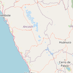
Map view of Huascarán National Park

Use this park location map to pinpoint Huascarán National Park in Peru, understand its exact geographic position, and read its mapped placement within the surrounding landscape more clearly.

Pigeon | © OpenStreetMap contributors

Location context for Huascarán National Park

Ancash
Natural feature types

Explore Named Natural Features Within Huascarán National Park

Gain deeper insight into the physical geography of Huascarán National Park by exploring its documented natural features. MoriAtlas provides a structured view of the peaks, glaciers, and alpine basins that define this unique mountain region in the Peruvian Andes.
Recorded earthquake history

Review the Historical Earthquake Catalogue for Huascarán National Park

Examine documented seismic records associated with the geography of Huascarán National Park. This catalogue provides organized data on past earthquake events, allowing for a clearer understanding of seismic history in the surrounding Andean terrain through MoriAtlas data.

Huascarán National Park Earthquake History

Catalogued events

23 events

Strongest magnitude

Magnitude 5.7

Most recent event

Dec 22, 2024

This history includes earthquakes recorded inside the park or within 50 km of its borders

Park atlas

Continue your park discovery by tracing regional protected landscapes and comparing the diverse Andean mountain geography surrounding Huascarán.

Explore Nearby National Parks and Protected Areas Beyond Huascarán, Peru's Andean Mountain Range

Continue your exploration beyond Huascarán National Park to browse other national parks and protected areas across Peru's vast Andean region, examining the varied glacial landscapes, high-altitude ecosystems, and conservation efforts. Discover how these distinct protected areas connect geographically, offering diverse terrain and ecological zones for comprehensive atlas-style comparison.
Nature reservePeru
26 km away#1 closest

Southeast

Cordillera Huayhuash Reserved Zone: Protected Mountain Geography and Andean Watersheds

High-altitude glacial terrain in central Peru

Cordillera Huayhuash Reserved Zone comprises a dense concentration of glacial peaks and highland basins. As a major source of water for both the Pacific coast and the Amazon, this protected area represents a unique geographic crossroads where ice fields and alpine puna support critical regional ecosystems in the heart of the Andes.

Area
675.9 km²
Established
2002
Relief
Mountain
Climate
Alpine
National parkSan Martín Region
85 km away#2 closest

North

Rio Abiseo National Park: Peru's Protected Landscape Identity and Geographic Context

Discover the mapped boundaries and regional atlas information.

Investigate Rio Abiseo National Park, a designated national park situated within the San Martín Region of Peru. This detailed entry focuses on its protected landscape characteristics and its specific geographic placement. Understand the park's mapped boundaries and its role in the broader atlas of protected areas, offering a structured approach to geographic discovery.

Area
2,745.2 km²
Established
1983
IUCN
II
Relief
Mountain
National parkHuánuco Region
126 km away#3 closest

East

Tingo María National Park: National Park Protected Landscape in Huánuco Region, Peru

Atlas exploration of park boundaries and regional geography.

Investigate Tingo María National Park, a key protected area situated in the Huánuco Region of Peru. This national park designation signifies its importance for understanding the country's natural landscapes and mapped geography. Explore its protected territory and discover its place within the regional atlas.

Area
47.778 km²
Established
1965
IUCN
II
Relief
Mountain
National parkPeru
137 km away#4 closest

Northeast

Cordillera Azul National Park: A National Park for Geographic Discovery in Peru

Explore Peru's protected landscape and regional map context.

Cordillera Azul National Park serves as a dedicated entry point for understanding Peru's protected natural areas through a geographic lens. This park's identity is tied to its specific mapped boundaries and its contribution to the nation's diverse terrain. Focusing on Cordillera Azul National Park allows for detailed atlas exploration of its unique landscape context within western South America, providing factual data for geographic understanding.

Area
13,531.9 km²
Established
2001
IUCN
II
Relief
Mountain
Wildlife reserveCajamarca Region
153 km away#5 closest

Northwest

Sunchubamba Game Reserve: Geographic Overview of Protected Andean Landscapes in Northern Peru

Examining dry forest ecosystems and managed habitat in the Cajamarca Region

Explore the unique environmental footprint of Sunchubamba Game Reserve, a protected area in northern Peru characterized by its blend of native dry forests and non-native tree plantations. This record details the reserve as a historical hacienda site that now serves as an important study in land-use, wildlife management, and the evolution of Andean highland conservation practices.

Area
597.35 km²
Established
1977
IUCN
VI
Relief
Mountain
National parkPasco Region
159 km away#6 closest

Southeast

Yanachaga, Chemillén National Park: Protected Area in Pasco Region, Peru

Mapped terrain, Pleistocene refuge, and rich biodiversity.

Yanachaga, Chemillén National Park, a national park situated in Peru's Pasco Region, preserves over 122,000 hectares of mountainous cloud forest and rainforest ecosystems. Its landscape is characterized by dramatic canyons and steep forested slopes, creating significant altitudinal variation from 460 to 3,643 meters. Recognized as a Pleistocene refuge, the park shelters ancient forest remnants and harbors exceptional biodiversity, including hundreds of bird species and iconic mammals, offering rich context for geographic and protected-area exploration.

Area
1,220 km²
Established
1986
IUCN
II
Relief
Mountain
Protected areaOxapampa Province
181 km away#7 closest

Southeast

Yanesha Communal Reserve: Geography and Protected Area Context in Oxapampa Province

A vital transition zone between the Andes and the Amazon

Gain insight into the physical character of Yanesha Communal Reserve, where humid tropical forests and river channels converge to form a complex ecosystem. This protected area offers a look at how sustainable land use and conservation intersect within the Palcazu River basin. Browse the geographic boundaries and mapped landscape features that define this essential region in central Peru.

Area
347.45 km²
Established
1988
IUCN
VI
Scope
Terrestrial
Nature reserveLima Region
About 186 km away#8 closest

South

Ancón Reserved Zone: Protected Coastal Desert and Bay Ecosystems in Lima Region

Coastal desert landscapes and marine habitat protection

The Ancón Reserved Zone represents a key protected area where the dry coastal plains of Peru reach the Pacific Ocean. Its mapped boundaries encompass a critical transition zone between arid desert terrain and marine environments, offering a concentrated look at specialized regional ecology within the Lima Province.

Area
21.93 km²
Established
2013
Relief
Lowland
Climate
Arid

Common questions about visiting, size, designation, and location context for Huascarán National Park

Huascarán National Park FAQs for park facts, access, geography, and protected area context

Find quick answers about Huascarán National Park, including protected-area facts, park geography, trail and visitor context, and how the park fits into its surrounding country and regional landscape.
MoriAtlas Explorer

Continue Your Protected Areas Search Across the Global Atlas

Deepen your exploration by continuing the structured search for national parks and protected areas worldwide. Utilize the comprehensive filtering capabilities to compare different conservation landscapes and refine your understanding of global park geography. Discover more about the distribution and characteristics of protected natural areas.

Global natural geography