
Streams
Park geography
A detailed spatial analysis of regional terrain, waterways, and alpine landscapes.
Comprehensive Geographic Profile and Mapped Boundaries of the John Muir Wilderness
Examine the physical characteristics and recorded geography of the John Muir Wilderness in California. This structured profile presents map boundaries, alpine relief data reaching 4421 meters, and extensive hydrographic systems including diverse lakes, streams, and wetlands contained within the protected area.
A high-Sierra wilderness of granite peaks, glacial lakes, and alpine meadows named for naturalist John Muir.
John Muir Wilderness
The John Muir Wilderness is a large federally designated wilderness area that stretches along the crest of the Sierra Nevada in eastern California. Spanning roughly 90 miles of high mountain country, the wilderness connects the Inyo and Sierra National Forests on both sides of the Sierra crest and forms a critical link in one of the most continuous high-elevation landscapes in the lower 48 states. Its terrain is defined by sharp granite peaks, deeply carved glacial canyons, and an extraordinary density of alpine lakes. The wilderness contains the largest contiguous area above 10,000 feet in the continental United States, along with the southernmost glacier in the country. It is named for John Muir, the Scottish-American naturalist whose writing and advocacy helped shape modern American conservation. Today the area is recognized as one of the most significant backcountry landscapes in the United States, valued alike for its geology, its alpine ecosystems, its wildlife, and its long hiking traditions along routes such as the John Muir Trail and the Pacific Crest Trail.
- Location
- United States of America
- Park type
- Wildlife reserve
- Established
- 1964
- Area
- 2,641.8 km²
- Highest point
- 4,421 m
Location overview
Country and regional jurisdiction records for the protected area
John Muir Wilderness Geography and Regional Setting
John Muir Wilderness is established within the United States of America and California. Administrative membership records outline the territorial framework and regional jurisdiction for the protected area.
- Countries
- United States of America
- Regions
- California
- Primary location
- California
Boundary and coordinates
Interactive boundary geometry and derived area measurements
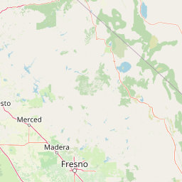
John Muir Wilderness Boundary Map and Geographic Extent
Mapped geographic outlines establish clear spatial context for the protected territory. Accompanying dimensional metrics outline total area span and coordinate limits without surveying claims.
- Boundary area
- 2,644.6 km²
- Boundary perimeter
- 871.6 km
- Northernmost point
- 37.6135° N
- Southernmost point
- 36.4633° N
- Easternmost point
- 118.0965° W
- Westernmost point
- 119.1318° W
- Geographic centre
- 37.1884° N, 118.722° W
- North–south span
- 127.6 km
- East–west span
- 92.1 km
Elevation and terrain
Mountain relief metrics and recorded water features
John Muir Wilderness Terrain and Elevation Summary
Recorded elevation metrics outline the vertical range of John Muir Wilderness, reaching a highest point of 4421 meters. Associated feature cards detail streams, lakes, and wetlands located within the protected area.
- Highest point
- 4,421 m
Selected named natural features
Peaks
Mist Peak
3,867.6 m
Streams
Rodgers Creek
Peaks
Mount Morrison
3,731 m
Streams
Middle Fork Bishop Creek
Mountain saddles
Granite Bear Pass
3,780 m
Environmental setting
Interpreting alpine relief, water presence, and rugged mountain terrain categories
John Muir Wilderness Environmental Classifications and Alpine Setting
Recorded landscape features and climate zones function as broad interpretive categories for physical setting analysis across the terrain. Stored environmental attributes connect directly to relevant atlas destinations where matching classifications are indexed.
- Relief
- Mountain
- Climate
- Alpine
- Water
- Major water bodies
Landscape features
Mountains · Valleys · Cliffs · Canyon · Forest · Lakes · Rivers · Glacier
Park atlas
Compare adjacent high Sierra wilderness areas and regional mountain terrain
Explore Parks Near John Muir Wilderness and Surrounding Protected Landscapes
Browse nearby national parks and protected areas sharing the rugged terrain of the eastern Sierra Nevada. Comparing adjacent wilderness landscapes provides broader geographic context for high elevation alpine ecosystems.

Protected landscapeCalifornia
Park boundaries overlap#1 closest
North

Inyo National Forest: An Atlas of Protected Landscapes and Sierra Nevada Geography
High altitude wilderness and volcanic terrain in Eastern California
Spanning from the arid Owens Valley floor to the 14,000 foot crest of the Sierra Nevada, Inyo National Forest remains a cornerstone of the American West. This protected landscape contains the Ancient Bristlecone Pine Forest, Mount Whitney, and the Mono Inyo volcanic chain, providing a dense geographic record of glacial, tectonic, and ecological diversity across a vast managed corridor.
- Area
- 7,702.71 km²
- Established
- 1907
- IUCN
- Ib
- Relief
- Mountain
National parkCalifornia
Park boundaries overlap#2 closest
Southeast
Kings Canyon National Park National Park: California Protected Landscape & Geography Atlas
Mapped park boundaries and regional natural context.
Kings Canyon National Park stands as a key protected national park within California, offering a specific focus for geographic understanding and atlas-based exploration. This page details the park's mapped boundaries and its integration into the broader regional geography of California. For users interested in the distribution of protected lands and the mapping of natural landscapes, Kings Canyon National Park provides a crucial point of study within the comprehensive park atlas.
- Area
- 1,869.25 km²
- Established
- 1890
- IUCN
- II
- Visitors
- 641K annual
National parkCalifornia
Park boundaries overlap#3 closest
South
Sequoia National Park National Park: Geographic Identity and Protected Landscape Atlas
Explore mapped boundaries and the terrain of this California protected area.
Gain a structured understanding of Sequoia National Park as a protected landscape, focusing on its mapped geographic boundaries and its context within California. This entry provides foundational data for exploring the park's natural terrain and its role in a broader atlas of conservation lands, ideal for users seeking detailed geographic information.
- Area
- 1,635.19 km²
- Established
- 1890
- IUCN
- II
- Visitors
- 1.2M annual

Protected landscapeCalifornia
Park boundaries overlap#4 closest
Northwest
Sierra National Forest: Protected Landscapes of the Central California Sierra Nevada
Geography of alpine lakes, conifer forests, and mountain basins
Spanning from 900 to nearly 14,000 feet in elevation, Sierra National Forest protects a massive vertical range of California terrain. Discover its iconic wilderness areas and reservoir-studded landscape, providing a deep look at the geographic connectivity between major national parks in the central Sierra Nevada.
- Area
- 5,300 km²
- Established
- 1893
- Relief
- Mountain
- Climate
- Alpine

Protected landscapeCalifornia
6.7 km away#5 closest
South
Sequoia National Forest: Protected Sierra Nevada Geography and Mountain Terrain
A vast protected landscape spanning 1.1 million acres in California
Spanning Tulare, Kern, and Fresno counties, Sequoia National Forest preserves iconic giant sequoia groves across multiple river watersheds. The terrain features vertical relief exceeding 11,000 feet, showcasing a range of ecosystems from chaparral slopes and coniferous forests to glacial cirques and granite spires located within the southern Sierra Nevada range.
- Area
- 4,829.17 km²
- Established
- 1908
- Relief
- Mountain
- Climate
- Mediterranean
Wildlife reserveFresno County
About 8 km away#6 closest
Northwest
Kaiser Wilderness: Exploring the Alpine Ridges and Glacial Terrain of the Central Sierra Nevada
A federally protected wilderness area in Fresno County, California.
Kaiser Wilderness offers a dense collection of signature Sierra Nevada landforms, including granite cliffs, subalpine forests, and high-altitude lakes. This wildlife reserve preserves a rugged, glacier-scoured interior that provides a distinct contrast to the surrounding regional landscape of the Sierra National Forest, making it a critical entity for understanding mid-elevation mountain ecology.
- Area
- 92 km²
- Established
- 1976
- IUCN
- Ib
- Relief
- Mountain
National parkCalifornia
20 km away#7 closest
Northwest
Yosemite National Park: Protected Landscape Identity and Geographic Atlas Context
Mapped boundaries and regional setting for a key California national park.
Delve into the protected landscape identity of Yosemite National Park, examining its specific geographic features and its place within the broader atlas of California's natural areas. This entry provides detailed context on its mapped boundaries, regional positioning, and significance as a protected natural site, essential for understanding its landscape and conservation geography.
- Area
- 3,070 km²
- Established
- 1890
- IUCN
- II
- Visitors
- 3.9M annual
Wildlife reserveTulare County
22 km away#8 closest
South
Jennie Lakes Wilderness in Tulare County: Sierra Nevada Protected Landscape Map
High-country geography and wilderness boundaries
Jennie Lakes Wilderness offers a distinct look at high Sierra Nevada topography, featuring granite ridges, alpine lakes, and deep canyons. This Tulare County reserve acts as a critical transition zone between adjacent national parks, preserving a diverse mix of subalpine forests and rugged mountain peaks within its 10,500 acre boundary.
- Area
- 42.72 km²
- Established
- 1984
- IUCN
- Ib
- Relief
- Mountain
MoriAtlas Explorer
Continue Exploring the Geography and Boundaries of John Muir Wilderness
Investigate the high-altitude terrain and protected boundaries of John Muir Wilderness through our detailed geographic data. Learn how these glacial landscapes and alpine peaks contribute to the broader Sierra Nevada mountain system on MoriAtlas. Access maps and structured facts to deepen your understanding of this significant California protected area.
Browse next
Global natural geography
Explore related park routes
Explore MoriAtlas Global ParksBrowse All MoriAtlas ParksGlobal Park Map DiscoveryMoriAtlas: Browse All CountriesBrowse All MoriAtlas ContinentsNational Park Environment AtlasGrand Canyon National Park AtlasYellowstone National Park AtlasYosemite National Park Atlas and GeographySerengeti National Park AtlasGalápagos National Park Protected LandscapeBanff National Park Geography and AtlasKruger National Park Atlas EntryUluṟu-Kata Tjuṯa National Park AtlasExplore Uluru-Kata Tjuta National Park GeographyPlitvice Lakes National Park AtlasFiordland National Park Protected LandscapeGreat Smoky Mountains National Park AtlasAfghanistan National Parks and Protected AreasAlbania National Parks and Protected AreasAlgeria National Parks and Protected AreasAmerican Samoa National Parks and Protected AreasAndorra National Parks and Protected AreasAngola National Parks and Protected AreasAntarctica National Parks and Protected AreasAntigua and Barbuda Park List