
Mori Atlas logo
Nature reserveNaturschutzgebitt Kelsbaach

Ecological contrasts of dolomite rock faces, limestone plateaus, and stream gorges within the Moselle valley

Naturschutzgebitt Kelsbaach Nature Reserve: Mapping Luxembourg Protected Geological Landscapes

(Naturschutzgebiet Kelsbaach)

Naturschutzgebitt Kelsbaach represents a significant protected area in Luxembourg, spanning 75 hectares of varied terrain above the Moselle river vineyard terraces. The geography of the reserve is defined by sharp ecological transitions, including sun-baked dolomite cliff formations, nutrient-poor dry grasslands, and a narrow, cool, mossy stream ravine. This compact site provides a rare look at the intersection of Luxembourgish limestone geology and the specialized habitats of the Moselle region.

limestone cliffsdolomite rocksdry grasslandswild orchidsstream gorgewall lizard habitat
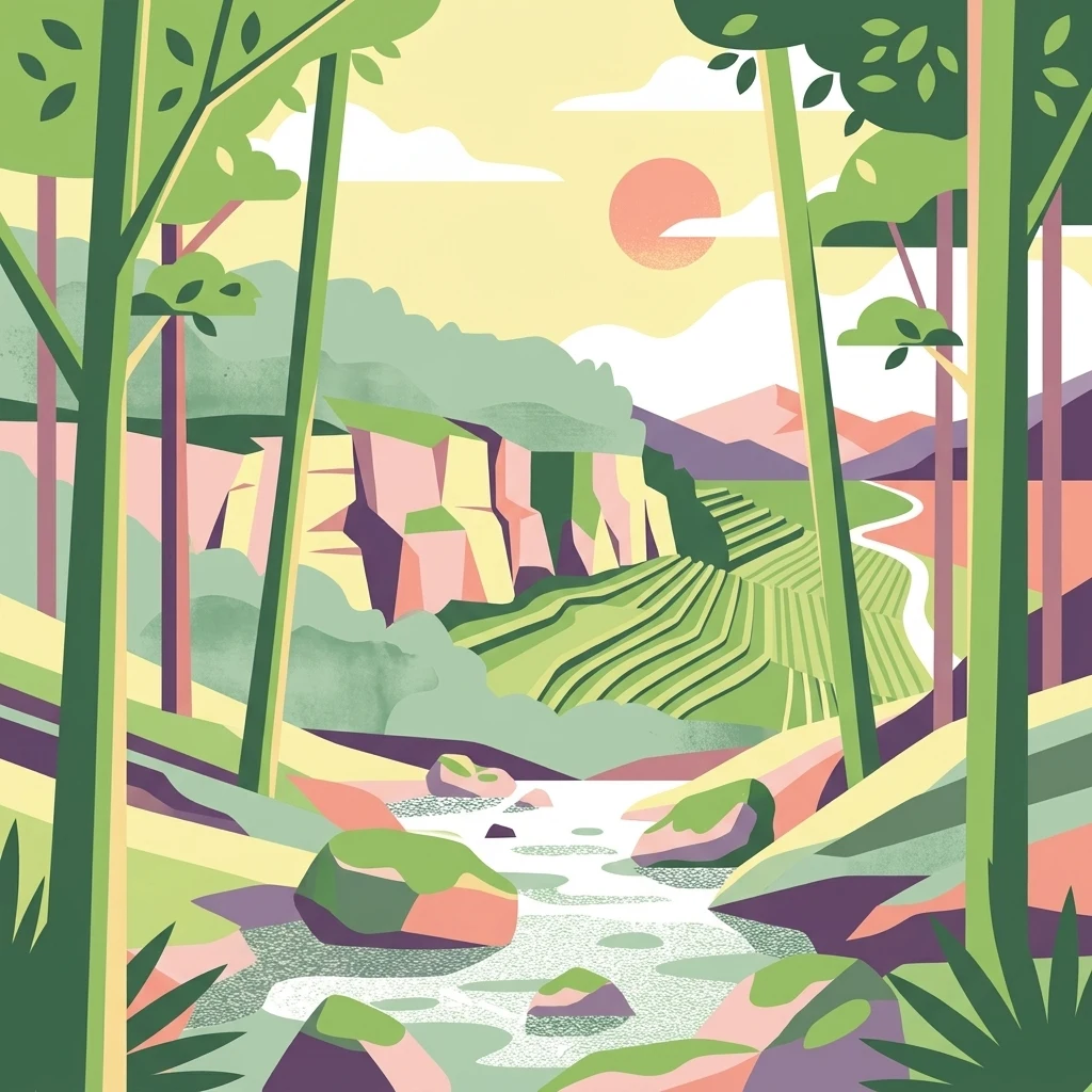
A flat style digital illustration of a nature reserve, featuring a stream in the foreground with mossy boulders, terraced green fields and a rocky cliff face in the midground, and a sunrise or sunset in the background.

Naturschutzgebitt Kelsbaach

Nature reserve

Park overview

Structured park overview, official facts, and landscape profile for Kelsbaach Nature Reserve

Kelsbaach Nature Reserve park facts, protected area profile, and essential visitor context

Review the core facts for Kelsbaach Nature Reserve, including designation, size, terrain, visitor scale, habitats, and operating context in one park-focused overview.

About Kelsbaach Nature Reserve

The Kelsbaach nature reserve lies in the heart of Luxembourg's lower Moselle wine region, between the town of Grevenmacher and the village of Machtum. Although the protected area covers only about 75 hectares, it manages to compress an unusually rich variety of landscapes, habitats, and geological history into a small footprint along the steep left bank of the Moselle.

Geologically, the reserve belongs to the Muschelkalk formations that characterise much of the Luxembourg Moselle region. A prominent rock wall is built on the Trochite layer, above which sits the younger Ceratite layer. The Ceratite rock, originally a marine sediment laid down in ancient seas, has been transformed by slow chemical processes into dolomite. Along the upper reaches of the Kelsbaach stream, this dolomite was quarried and mined well into the 20th century for building stone, fertilizer, flour, and cement production. Remains of an old dolomite gallery are still visible near the mouth of the Kelsbaach gorge.

The landscape itself is shaped by both geology and water. The Kelsbaach runs through a narrow, steep, and deeply shaded gorge. In heavy rain it becomes a waterfall plunging into the shadowy ravine, while in high summer it can dry up almost completely. This shifting water regime, combined with the steep slopes and unstable ground above the impermeable marl of the Middle Muschelkalk, has triggered major landslides in the past, including the prehistoric formation of the Longkaul breach above Wellbierg and a 1964 slide that destroyed the Deisermillen mill complex.

Ecologically, the reserve is significant for the contrast it preserves between extreme habitats. Dry, sunlit dolomite rock faces and old vineyard terraces support heat-loving reptiles and drought-adapted plants, while the cool humid gorge supports mosses, ferns, and moisture-loving trees such as sycamore, wych elm, and large-leaved lime. On the plateau above, the nutrient-poor calcareous grasslands are home to several protected orchid species. This combination of microclimates, geology, and cultural landscape makes Kelsbaach one of the more ecologically concentrated natural sites in Luxembourg's Moselle valley.

Quick facts and research context for Kelsbaach Nature Reserve

Located on the left bank of the Moselle in eastern Luxembourg, the Kelsbaach reserve spans parts of the communes of Flaxweiler, Wormeldange, and Grevenmacher. It covers roughly 75.45 hectares and has been formally protected as a national-interest nature reserve since 3 August 1998, with national code PS 09.

The site is defined by a sharp ecological contrast: hot, dry dolomite cliffs above the vineyards, cool and humid conditions along the Kelsbaach stream, and species-rich dry grasslands on the plateau. These grasslands are notable for protected orchids, and the warm rock faces shelter specialized reptile and plant species adapted to heat and drought. The reserve is also part of a cultural landscape shaped by 2,000 years of viticulture around Grevenmacher.

Protection and recognition

Documented terrestrial protection history established in 1998

Naturschutzgebitt Kelsbaach Protection Status and Designation History

Naturschutzgebitt Kelsbaach holds a recorded terrestrial protection status established in the designated year of 1998. Review the structured conservation history, management scope, and verified designation records for this protected area.

Protection details

Protection scope
Terrestrial
Designated year
1998
Transboundary protection
No
Park context

Deeper park guide and search-rich context for Kelsbaach Nature Reserve

Kelsbaach Nature Reserve history, landscape, wildlife, and travel context

Explore Kelsbaach Nature Reserve through its history, landscape character, ecosystems, wildlife, conservation priorities, cultural context, and seasonal travel timing in a structured park guide built for atlas discovery and search intent.

Why Kelsbaach Nature Reserve stands out

Kelsbaach is best known for its combination of calcareous and dolomitic geology, including the marked rock walls above the Moselle vineyards formed by the Trochite and Ceratite layers of the Luxembourg Muschelkalk. The reserve's plateau is celebrated for its nutrient-poor, lime-rich dry grasslands that support rare wild orchids, including military orchid, lizard orchid, and man orchid. Equally distinctive is the dramatic environmental contrast within the reserve itself. Above the vineyards, sun-warmed dolomite cliffs host heat-loving species such as wall lizards and drought-adapted plants like white stonecrop and rusty-back fern. Below, the narrow Kelsbaach gorge forms a cool, mossy, humid microclimate where moisture-loving trees and stream-dwelling birds thrive. This juxtaposition of hot dry cliff and cool shaded ravine, within a short distance, gives the reserve a striking ecological signature along the Luxembourg Moselle.
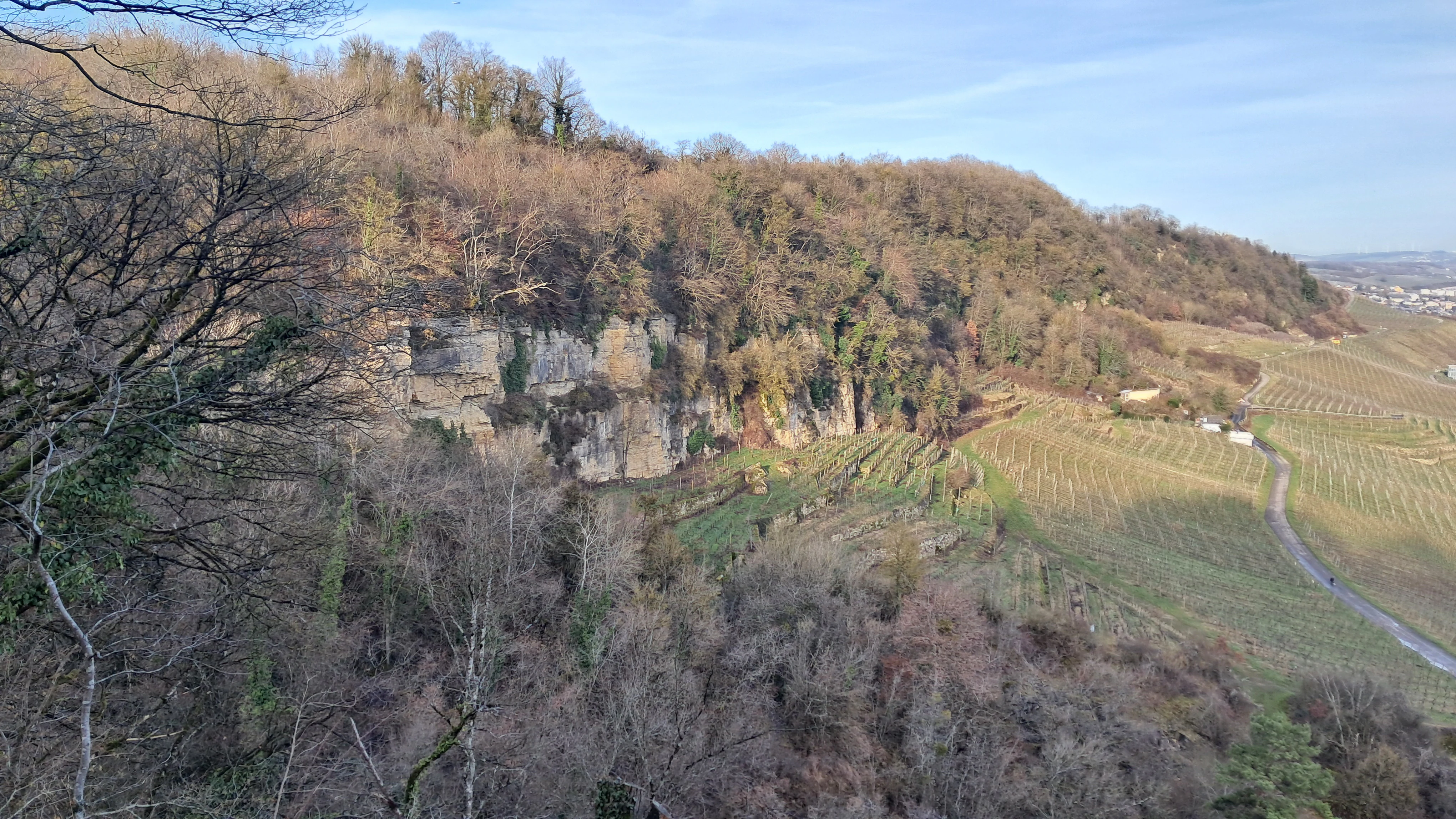
A wide view of a forested hillside with exposed rocky cliffs in the Naturschutzgebitt Kelsbaach nature reserve, with terraced vineyards visible on the side.
The wooded slopes and exposed rock formations of the Kelsbaach nature reserve near Grevenmacher.

Kelsbaach Nature Reserve history and protected-area timeline

The natural and cultural history of the Kelsbaach area stretches back millennia. The underlying geology reveals an ancient marine past, with limestone and dolomite formed from layers of marine life that were later transformed chemically into the dolomite cliffs visible today along the Moselle.

Human use of the area is equally long-lived. The dolomite of the Ceratite layer was quarried and mined for centuries, and well into the 20th century the rock was extracted for use as building stone, fertilizer, milling flour, and cement. Transport of the heavy stone to the Moselle was originally carried out by a small rail system and later a cable railway down to the riverbank. A labyrinth-like gallery from these former workings can still be visited near the entrance of the Kelsbaach gorge.

The unstable geology of the valley, with hard limestone and dolomite of the Upper Muschelkalk resting on the impermeable, slippery marl of the Middle Muschelkalk, has repeatedly caused major landslides. In prehistoric times, a massive slide formed the broad Longkaul depression on the plateau above Wellbierg. A more recent and very large event occurred in December 1964, when roughly a million cubic metres of soil and rock began to slide across a 250-metre-wide front between the Kelsbaach and the Deisermillen, ultimately destroying the historic mill complex that had stood on the Moselle road. The Deisermillen system had been fed by eight springs that once powered four separate mills along the stream's descent to the river.

The area formally became a protected nature reserve on 3 August 1998, through a Grand Ducal regulation covering approximately 75.45 hectares. In 2002, the Forestry Administration, together with the Commune of Grevenmacher, established a 4 km 'Wine and Nature' discovery trail, formalising public access and interpretation of the reserve's geology, biodiversity, and two-thousand-year viticultural history associated with Grevenmacher.

Kelsbaach Nature Reserve landscape and geographic character

The landscape of the Kelsbaach reserve is defined by an unusually compressed vertical and ecological gradient along the Luxembourg Moselle. From the river, the vineyards climb up the slope in a series of man-made terraces until they reach the base of a striking limestone wall, the Trochite layer, which forms a clear geological horizon across the hillside. Above this wall, the younger Ceratite layer sets the upper slope and plateau, and it is here that the reserve's most distinctive rocky terrain begins.

Much of the plateau and upper slope is built on dolomite, a rock transformed from the original marine Ceratite limestone through natural chemical change. This dolomite gives the area its dry, rocky character and supports both the dramatic white rock faces and the sparse, arid grasslands on the upper plateau. The surface heat is intense in summer, and cracks, ledges, and rocky crevices shape every habitat visible on the slope.

The most visually striking feature of the reserve is the Kelsbaach gorge itself. The stream has cut a narrow, steep, shaded ravine into the hillside, producing a cool, moist, almost cave-like atmosphere that contrasts sharply with the hot, exposed rock above. In winter and after heavy rains, the Kelsbaach tumbles into this gorge as a small waterfall, while in late summer the stream can shrink to almost nothing. The result is a small but dramatic canyon, set right above the famous vineyard terraces of the Moselle valley and offering one of the most concentrated landscape contrasts in Luxembourg's wine country.
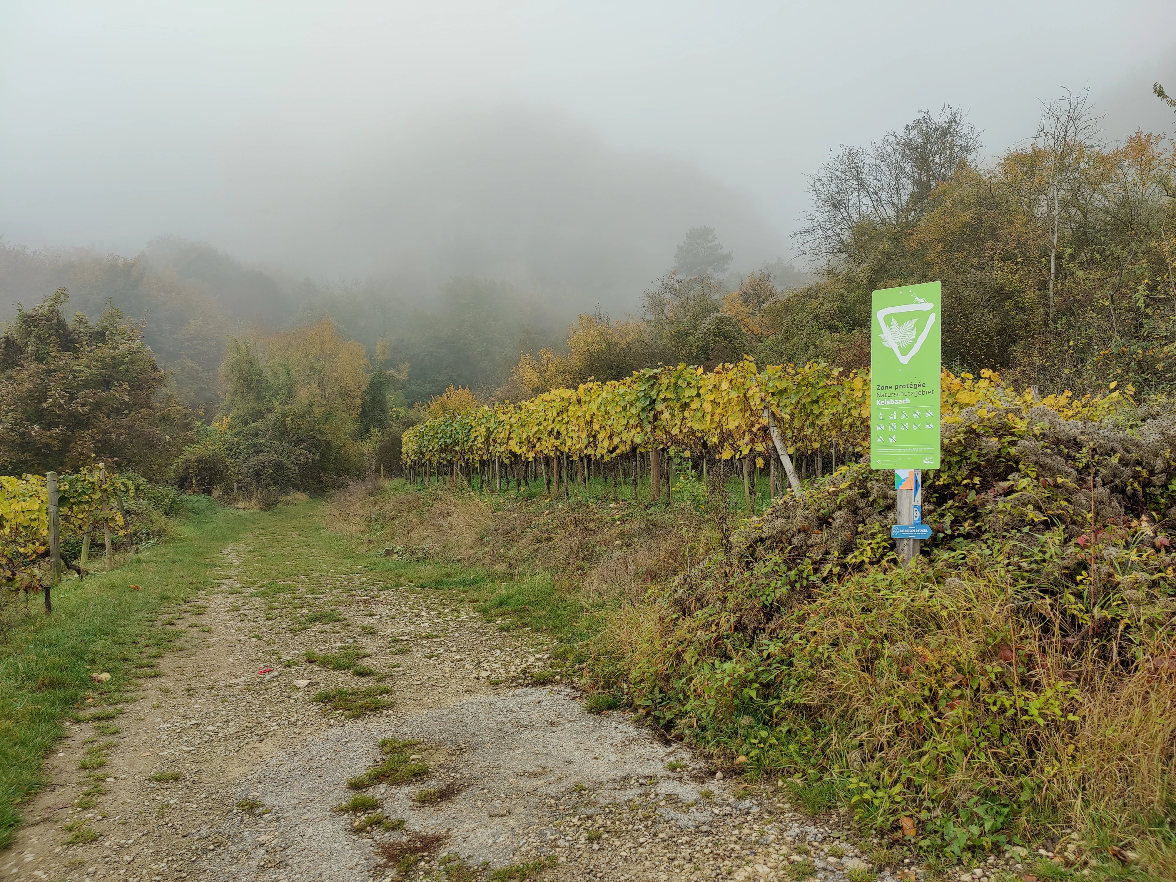
A dirt trail winds past a line of autumn-colored grapevines with a green nature reserve sign on the right; the background is obscured by thick fog.
A green nature reserve sign marking a vineyard area at Naturschutzgebitt Kelsbaach.

Kelsbaach Nature Reserve ecosystems, habitats, and plant life

Ecologically, the Kelsbaach reserve is best understood as a mosaic of three strongly contrasting habitat types packed into a small area. Each habitat reflects the underlying geology, exposure, and water regime of its specific location on the slope above the Moselle.

On the sun-exposed dolomite cliffs and rocky slopes, conditions are hot and dry. Here, habitats are dominated by drought-adapted plants, scattered shrubs, and reptiles specialised for warm rock faces. The microclimate of these rocks allows species more typical of Mediterranean environments to thrive in the heart of Luxembourg. Stone walls and terraces along the Wellbierg vineyards provide similar conditions, supporting additional heat-loving flora and fauna in small artificial habitats.

The Kelsbaach gorge is the ecological opposite of the cliffs above it. Inside the narrow ravine, the air is cool, damp, and shaded. Mosses and humidity-loving plants colonise the rocks and soil, and the canopy is dominated by moisture-loving deciduous trees such as sycamore maple, wych elm, and large-leaved lime. The original calcareous beech forest that once occupied the slope above the cliffs has been largely altered by human activity into a mixed woodland with hazel and field maple; nevertheless, fragments of these lime-rich woodlands still influence the area's character.

The plateau grasslands above the cliff form perhaps the most ecologically distinctive habitat in the reserve. These nutrient-poor, calcareous dry grasslands, populated with low herbs and characteristic steppe-like species, support several protected wild orchids. Together, these grassland, cliff, and gorge habitats make the reserve a textbook example of how a small area can combine geological variety with strong ecological contrasts.

Kelsbaach Nature Reserve wildlife and species highlights

The wildlife profile of Kelsbaach reflects the reserve's strong contrast between dry, exposed rock habitats and the cool, sheltered Kelsbaach gorge. Different groups of animals dominate each of these worlds, and the reserve is notable for the unusual presence of more southerly species in a Luxembourgish setting.

On the warm dolomite cliffs and old vineyard walls, the most visible species is the common wall lizard, a heat-loving reptile that hunts insects among the rocks and is agile enough to scale even vertical stone surfaces. The dry, sun-baked rock faces also support a community of drought-adapted invertebrates, including the butterfly fauna typical of calcareous grasslands and dry slopes.

The Kelsbaach gorge supports a very different set of species. The clear, fast-flowing, and rocky sections of the stream provide hunting habitat for the white-throated dipper, a stream-dwelling songbird that searches for insect larvae and small aquatic invertebrates among the stones. The grey wagtail is also regularly present along the watercourse, feeding along the edges of the stream in the shaded, mossy environment. Amphibians and moisture-loving invertebrates also benefit from the persistent humidity of the gorge.

On the dry plateau grasslands, the rich wildflower communities, particularly of orchids, attract a wide range of pollinators, especially butterflies, which are drawn to the nectar of rare orchid species such as military orchid, lizard orchid, and man orchid. The combination of dry grassland, rocky cliff, shaded gorge, and vineyard edge gives the reserve an unusually diverse fauna for its small size, but the wildlife story is fundamentally one of two very different microclimates sitting on top of one another.

Kelsbaach Nature Reserve conservation status and protection priorities

Kelsbaach has been formally protected as a nature reserve of national interest since 3 August 1998, under Grand Ducal regulation covering roughly 75.45 hectares. The decision to protect the area reflects both the high ecological value of its habitats and the fragility of the dry calcareous grasslands and cliff ecosystems that depend on very specific site conditions.

From a conservation perspective, the reserve's most important contribution is the preservation of nutrient-poor, calcareous dry grasslands on limestone and dolomite. These habitats are exceptionally rich in plant species, including several protected wild orchids, but they are also vulnerable: they depend on low nutrient levels and traditionally open conditions, and they can easily be lost if the land is fertilised, afforested, or abandoned without management.

Equally important is the protection of the geological-climatic mosaic itself. The contrast between hot dry dolomite cliffs and a cool shaded stream gorge supports a genuinely rare combination of Mediterranean-like and central European species in a single small site. Protecting both the rocky outcrops and the watercourse ensures that specialised cliff species, stream wildlife, and grassland flora can continue to coexist. The surrounding cultural landscape, including old stone walls and vineyard terraces, is also recognised as an important habitat in its own right, providing additional niches for the reserve's reptiles and drought-adapted plants.

The 2002 establishment of the 4 km Wine and Nature discovery trail reflects the fact that conservation here is closely linked with public access and education. By channeling visitors along an established route and providing interpretive stations, the management aims to balance the area's scientific and ecological value with its cultural heritage and recreational use along the Luxembourg Moselle.

Kelsbaach Nature Reserve cultural meaning and human context

Kelsbaach sits within one of the oldest and most intensely cultivated wine regions in Luxembourg, and the protected area reflects thousands of years of human shaping of the landscape. The Moselle vineyards between Grevenmacher and Machtum have been worked for around two millennia, and the dry stone terraces climbing up the slope from the river are themselves a recognised cultural and ecological feature, providing habitat for heat-loving species such as wall lizards and rare ferns.

The reserve also preserves evidence of older extractive industries. The dolomite of the upper Ceratite layer was historically mined and quarried for use as building stone, fertiliser, flour, and cement. The transport of this heavy material was supported first by a small rail line and later by a cable railway descending to the Moselle. A labyrinth-like gallery from this mining past can still be visited at the entrance to the Kelsbaach gorge, making the area a working link between natural and industrial heritage.

Equally important is the history associated with the Deisermillen. Eight springs along the Kelsbaach once fed a system of four mills arranged in sequence: a limestone and oil mill, an oak bark mill, and a tanning mill along the Moselle road. The 1964 landslide destroyed this complex, and its disappearance is part of the reserve's living memory. The 2002 discovery trail deliberately integrates these cultural layers, weaving together viticulture, mining, milling, and nature into a single narrative of the Luxembourg Moselle landscape.

Top sights and standout views in Kelsbaach Nature Reserve

The reserve's defining quality is the tight concentration, within just over 75 hectares, of three sharply contrasting habitats: sun-baked dolomite cliffs, a cool mossy stream gorge, and species-rich calcareous dry grasslands on the plateau. Combined with a strongly expressive geology of limestone and dolomite, this creates one of the most compact and varied ecological sites along Luxembourg's Moselle.

Visitors and conservation interest focus on several standout features: rare wild orchids in the plateau grasslands, heat-loving reptiles and drought-adapted plants on the cliffs and old vineyard walls, white-throated dippers and grey wagtails along the Kelsbaach stream, and visible traces of 2,000 years of human history in quarrying, milling, and wine-growing. The 4 km Wine and Nature discovery trail links these features in a single accessible circuit starting from Grevenmacher, Machtum, or the Deisermillen site.

Best time to visit Kelsbaach Nature Reserve

Spring is widely the most rewarding season to experience the Kelsbaach reserve, when the dry grasslands on the plateau come into flower and the wild orchids, including military orchid, lizard orchid, and man orchid, are at their most visible. This is also when temperatures on the exposed dolomite cliffs are warm enough to be lively without being oppressive, and reptiles such as the common wall lizard are most active and easiest to observe.

Summer brings the driest conditions in the reserve. The dolomite rocks and vineyard walls are at their hottest, supporting heat-loving species, but the Kelsbaach stream itself may shrink to almost nothing, and waterfalls along the gorge only appear during heavy rainfall. Autumn is generally a calmer season, with softer light on the Moselle vineyards and the rock walls, and stable conditions for walking the discovery trail. Winter, after rain or snowmelt, is the best time to witness the Kelsbaach in its most dramatic form, when it cascades into the gorge as a seasonal waterfall.


Monthly climate preview

Long-term representative temperature and precipitation averages for Luxembourg

Naturschutzgebitt Kelsbaach Climate Normals and Annual Weather by Month

Representative coordinate records show average monthly temperatures ranging from near freezing to warm summer maximums alongside steady precipitation throughout the year. Reviewing the complete twelve-month profile provides deeper analytical context on long-term thermal and moisture rhythms across the terrain.
Annual mean9 °C
0 °C19 °C
Jan
Feb
Mar
Apr
May13°
Jun17°
Jul19°
Aug19°
Sep14°
Oct
Nov
Dec
Warmest month
July

19.1 °C

Coolest month
January

0.4 °C

Wettest month
December

2.7 mm/day

Driest month
April

1.6 mm/day

Park location guide

Geography guide, regional context, and park location map for Kelsbaach Nature Reserve

Kelsbaach Nature Reserve park geography, regions, and map view in Luxembourg

Understand where Kelsbaach Nature Reserve sits in Luxembourg through a broader geographic reading of the surrounding landscape, nearby location context, and its mapped position within the national park landscape.

How Kelsbaach Nature Reserve fits into Luxembourg

Luxembourg is a small landlocked nation in Western Europe and the world's only grand duchy. It borders Belgium, Germany, and France, with Luxembourg City as its capital and largest city. The country has one of the highest GDP per capita figures globally and hosts several EU institutions, notably the Court of Justice. Its population of nearly 700,000 is multinational, with Luxembourgish as the national language and French and German as administrative languages.

Wider geography shaping Kelsbaach Nature Reserve in Luxembourg

Luxembourg is located in Western Europe, landlocked between Belgium to the west and north, Germany to the east, and France to the south. The terrain consists largely of forested uplands and plains in the Oesling region to the north, with the Gutland region in the south featuring more fertile land. The country covers 2,586 square kilometres, making it Europe's seventh-smallest nation.

Map view of Kelsbaach Nature Reserve

Use this park location map to pinpoint Kelsbaach Nature Reserve in Luxembourg, understand its exact geographic position, and read its mapped placement within the surrounding landscape more clearly.

Pigeon | © OpenStreetMap contributors

Visualizing dolomite cliffs, dry grasslands, and the Kelsbaach stream gorge

Naturschutzgebitt Kelsbaach Photos and Landscape Scenery

Visual records reveal the complex terrain, sun-baked rock faces, and shaded ravine habitats characteristic of Naturschutzgebitt Kelsbaach. Examining these protected landscapes helps observers understand the dramatic ecological contrast compressed across the Moselle valley hillside.

A wide view of a forested hillside with exposed rocky cliffs in the Naturschutzgebitt Kelsbaach nature reserve, with terraced vineyards visible on the side.

A small stream flows over rocks through a wooded forest area with mossy banks and dormant trees.

A dirt trail winds past a line of autumn-colored grapevines with a green nature reserve sign on the right; the background is obscured by thick fog.

Park atlas

Compare regional park geography, limestone formations, and connected river valley habitats.

Explore Parks Near Naturschutzgebitt Kelsbaach and Surrounding Protected Landscapes

Visitors browsing Naturschutzgebitt Kelsbaach can examine adjacent protected areas and nearby valley reserves to evaluate shared regional geological patterns. Expanding the search reveals how different limestone formations, river gorges, and dry grassland habitats connect across the surrounding terrain.
Nature reserveRheinland-Pfalz
About 3.4 km away#1 closest

Southeast

Langheck bei Nittel Nature Reserve: A Detailed Atlas of Protected Moselle Landscapes

Ecological geography and calcareous grassland habitat in Rheinland-Pfalz

Langheck bei Nittel is a significant nature reserve located in the Upper Moselle valley of Germany. The site protects a rare mosaic of calcareous dry grasslands, shrubbery, and forest edges that host a high concentration of orchid species. As a critical component of the regional biotope network, it offers insight into the conservation of warm-loving flora and the management of stony, nutrient-poor landscapes.

Area
0.42 km²
Established
1998
Watercolor painting of a green, rolling hillside landscape with faint pink floral details in the foreground.
Nature reserveRheinland-Pfalz
About 8.6 km away#2 closest

Northeast

Perfeist bei Wasserliesch: Protected Grassland and Botanical Mapping in Rheinland-Pfalz

A regional sanctuary for rare orchids and calcareous meadow flora.

Perfeist bei Wasserliesch represents a significant protected area within the German Moselle landscape. Spanning 22 hectares of dry, sun-exposed calcareous soil on the Liescher Berg, the reserve offers a focused look at open grassland ecology. Its unique status as a botanical reference point highlights how small-scale protected land maintains rare plant species and fragile meadow habitats against the backdrop of the surrounding Moselle valley hill country.

Area
0.22 km²
Established
1986
Nature reserveRhineland-Palatinate
About 12 km away#3 closest

East

Wiltinger Saarbogen: Mapping the Natural Saar River Meander and Floodplain Habitats

A critical protected nature reserve in the Rhineland-Palatinate river landscape.

Wiltinger Saarbogen remains a rare, natural river arc within the Saar valley. This protected area offers a deep look into riverine geography, featuring a concentrated mosaic of gravel banks, reed-fringed wetlands, and riparian forests that stand in contrast to the engineered shipping canals of the region.

Area
1.67 km²
Established
1997
Nature reserveLuxembourg
About 12 km away#4 closest

West

Cornelysmillen-Schucklai Nature Reserve: Geographic and Protected Area Overview

Wetland ecosystems on the Luxembourg plateau

Cornelysmillen-Schucklai serves as a key protected area of national interest, encompassing a mosaic of marshland, meadows, and deciduous woodland. This reserve acts as a vital corridor for moisture-dependent plant communities and threatened bird populations, defining the hydrological character of the plateau region with its intricate stream systems and restored pond basins.

Area
1.437 km²
Established
2023
Relief
Upland
Climate
Temperate
Watercolor painting of a green, rolling landscape with scattered trees and soft, faded hills in the background.
Nature reserveLuxembourg
About 12 km away#5 closest

West

Naturschutzgebitt Aarnescht Nature Reserve; Geographic Atlas and Protected Area Profile

Exploring calcareous dry grasslands and ecological mosaic habitats in Luxembourg

Discover the geographic composition of Naturschutzgebitt Aarnescht, a premier nature reserve in Luxembourg. This profile details the site's unique Keuper sediments, extensive orchid populations, and varied terrain, including traditional orchards and oak low-forests that form a vital protected landscape.

Area
0.752 km²
Established
1988
Relief
Upland
Climate
Temperate
A horizontal watercolor painting depicting a gentle river flowing through a soft green landscape with trees and distant rolling hills.
Nature reserveLuxembourg
About 14 km away#6 closest

West

Naturschutzgebitt Birelergronn Nature Reserve: Luxembourg Protected Valley Geography

A sandstone valley landscape in central Luxembourg.

Naturschutzgebitt Birelergronn encompasses a 270 hectare nature reserve in Luxembourg, recognized for its complex hydrological features and historic milling valley structure. The area highlights the geological significance of the Luxembourg Sandstone, supporting diverse alluvial forests and the expansive Neimillen wetland complex which defines the regional ecosystem.

Area
2.717 km²
Established
1999
Relief
Upland
Climate
Temperate
Watercolor painting of a rolling green forest landscape with a winding path and soft, abstract hills in the background.
Nature reserveRhineland-Palatinate
About 16 km away#7 closest

East

Mattheiser Wald Nature Reserve: A Protected Forest Landscape in Rhineland-Palatinate

Ecological mapping of urban forest and valley terrain

Mattheiser Wald represents a vital nature reserve and Natura 2000 site in the Trier region. The area is characterized by high-value oak and hornbeam woodland, abandoned military disturbance zones that host rare wildlife, and an intricate stream valley system. This atlas entry provides a detailed look at the reserve's topography and its status as a critical conservation landscape within an urban environment.

Area
4.47 km²
Established
2003
Relief
Upland
Climate
Temperate
A horizontal watercolor painting of a wetland scene with still water, grassy banks, small islands, and rolling hills in the background.
Nature reserveSchengen
About 17 km away#8 closest

South

Haff Réimech Nature Reserve: Wetland Geography and Protected Landscape in Schengen

Reclaimed industrial wetlands in the Moselle river valley

Haff Réimech is a protected wetland sanctuary located in the Moselle valley near Schengen. The reserve features approximately forty shallow lakes created from former sand and gravel pits, now surrounded by reedbeds and riparian woodland. This mosaic landscape serves as a key site for migratory bird species, demonstrating a unique transition from industrial extraction to a managed, ecologically rich floodplain environment.

Area
1.008 km²
Established
1998
Relief
Lowland
Climate
Temperate

Common questions about visiting, size, designation, and location context for Kelsbaach Nature Reserve

Kelsbaach Nature Reserve FAQs for park facts, access, geography, and protected area context

Find quick answers about Kelsbaach Nature Reserve, including protected-area facts, park geography, trail and visitor context, and how the park fits into its surrounding country and regional landscape.
MoriAtlas Explorer

Continue Your Protected Areas Search Across the Global Atlas

Deepen your exploration by continuing the structured search for national parks and protected areas worldwide. Utilize the comprehensive filtering capabilities to compare different conservation landscapes and refine your understanding of global park geography. Discover more about the distribution and characteristics of protected natural areas.

Global natural geography