Mori Atlas logo
Nature reserveKleine Schorfheide

Tracing the boundaries of former military training grounds, Havel floodplains, and lake mosaics in Northern Brandenburg

Kleine Schorfheide Nature Reserve: Mapped Protected Landscapes and Geographic Context in Brandenburg, Germany

(Naturschutzgebiet Kleine Schorfheide)

Kleine Schorfheide encompasses 73.75 square kilometres of protected terrain in northern Brandenburg, spanning the districts of Oberhavel and Uckermark. This nature reserve preserves a distinct mosaic of formerly unmanaged military training grounds, the near-natural Havel river floodplain, and the extensive Himmelpforter Heide forest. By integrating diverse habitats including open heath-like terrain and multiple lake systems like Tangersdorfer See, the reserve functions as a critical example of regional landscape-level conservation.

nature reserveBrandenburgmilitary training ground landscapeopen heathmixed forestHimmelpforter Heide

Kleine Schorfheide

Nature reserve

Park overview

Structured park overview, official facts, and landscape profile for Kleine Schorfheide

Kleine Schorfheide park facts, protected area profile, and essential visitor context

Review the core facts for Kleine Schorfheide, including designation, size, terrain, visitor scale, habitats, and operating context in one park-focused overview.

About Kleine Schorfheide

Kleine Schorfheide is a state-level nature reserve in northern Brandenburg that draws its identity from a combination of past military use, riverine landscape and extensive forest. Covering about 73.75 square kilometres, the reserve extends across parts of the Oberhavel and Uckermark districts, reaching into the areas of Fürstenberg/Havel, Zehdenick, Lychen and Templin. Its roughly 18 kilometre east-west extent connects the former Tangersdorf and Vogelsang military training grounds, the natural Havel floodplain between them, and the Himmelpforter Heide, a large forested area in the western part of the protection zone.

Because large portions of the reserve were used as military training areas in earlier decades, the landscape includes extensive tracts of previously unmanaged, non-agricultural land. These open, undisturbed surfaces are a defining element of the protected area and one of the main reasons for its designation. The intervening Havel floodplain adds a near-natural river landscape with associated wetlands and waterbodies, reinforcing the ecological coherence of the reserve.

Within its boundaries, the reserve encompasses a chain of named lakes that contribute to the lake-rich character typical of the Brandenburg landscape. These include the Tangersdorfer See, the Großer Kramssee, the Haussee near Barsdorf, the Großer Beutelsee, the Großer Kuhwallsee and the Großer Lankensee. Together, they create a varied mosaic of aquatic habitats interspersed with the open former training grounds and the coniferous and mixed woodlands of the Himmelpforter Heide.

The site is partially integrated into the European Union Natura 2000 network through the Habitats Directive site known as "Kleine Schorfheide-Havel". Its current legal basis is the protection ordinance of 21 July 2000, which superseded earlier arrangements. The reserve therefore serves both as a Brandenburg-level protection area and as part of the broader European ecological network for threatened habitat types and species.

Quick facts and research context for Kleine Schorfheide

Kleine Schorfheide is a Brandenburg state nature reserve of about 73.75 square kilometres that extends roughly 18 kilometres across the northern part of the state. It straddles the Oberhavel and Uckermark districts and is managed under a protection ordinance from 21 July 2000, with the site originally established before 1994. The reserve is partly integrated into the Natura 2000 network as part of the FFH area "Kleine Schorfheide-Havel". Its core components are the former Tangersdorf and Vogelsang military training grounds, the near-natural Havel floodplain that links them, the Himmelpforter Heide forest area, and a series of named lakes.

Protection and recognition

Examine the documented protection status and governance records for Kleine Schorfheide.

Kleine Schorfheide Protection Status and International Recognition Data

Kleine Schorfheide maintains structured protected area designation records and official database entries within international conservation inventories. Reviewer data compiles verified protection status frameworks, management parameters, and historical designation milestones for geographical analysis.

Protection details

WDPA ID
318663
Park context

Deeper park guide and search-rich context for Kleine Schorfheide

Kleine Schorfheide history, landscape, wildlife, and travel context

Explore Kleine Schorfheide through its history, landscape character, ecosystems, wildlife, conservation priorities, cultural context, and seasonal travel timing in a structured park guide built for atlas discovery and search intent.

Why Kleine Schorfheide stands out

The reserve is best known for its large, formerly militarily used open landscapes that have been preserved in an unmanaged state, combined with a near-natural stretch of the Havel river floodplain and the adjoining Himmelpforter Heide forest. Together, these areas form a contiguous mosaic of former training grounds, woodland and lake-rich lowlands that gives the site its distinctive ecological character.
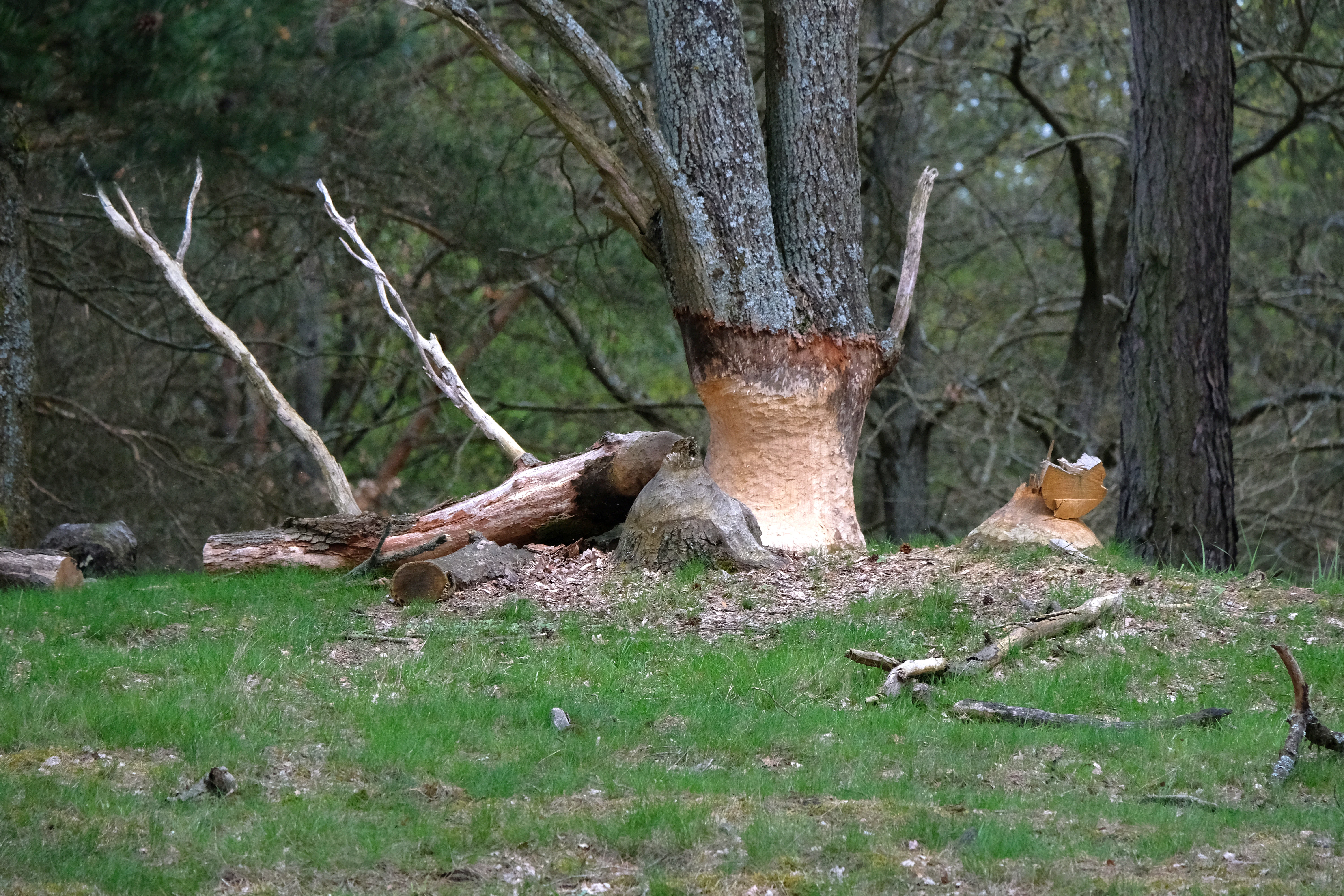
A thick tree trunk in a forest with deep, light-colored tooth marks circling the base, indicating activity by beavers, with fallen branches on the grassy ground nearby.
A tree trunk showing clear signs of beaver gnawing in the Kleine Schorfheide nature reserve.

Kleine Schorfheide history and protected-area timeline

The lands that now make up the Kleine Schorfheide were used as military training grounds at Tangersdorf and Vogelsang, and the surrounding landscape was shaped by that long period of restricted access and non-agricultural use. The area was designated as a nature reserve before 1994, in recognition of the unusual condition of these previously unmanaged open landscapes and of the connecting Havel floodplain and Himmelpforter Heide forest area.

The reserve's current form is defined by a protection ordinance issued on 21 July 2000, which has since governed land use, conservation measures and protective provisions within the site. Over time, parts of the reserve have also been formally included in the European Natura 2000 network through the Habitats Directive area "Kleine Schorfheide-Havel", extending its significance beyond Brandenburg to the wider European conservation framework.

The reserve's published literature includes a 1993 article in "Naturschutz und Landschaftspflege in Brandenburg", in which Ernst Preis and Norbert Bukowsky discussed the area as part of a series on nature and conservation on Brandenburg's former military training grounds.

Kleine Schorfheide landscape and geographic character

The landscape of the Kleine Schorfheide is shaped by a transition between wide, open, formerly militarily used terrain and forested, lake-rich lowland. The broad sandy and dry open areas of the former Tangersdorf and Vogelsang training grounds still bear the imprint of past military activity and, freed from cultivation, have developed their own characteristic mosaic of heath-like vegetation, grassland and bare ground.

Between and around these open tracts sits the near-natural floodplain of the Havel river, with meandering channels, wet meadows and riparian structures that contrast with the drier, more elevated areas. To the west, the Himmelpforter Heide adds an extensive forested heathland, giving the reserve a marked vertical and ecological variation. This combination of open ground, riverine wetland and woodland creates a diverse, scannable landscape across the reserve's roughly 18 kilometre length.

Embedded in this mosaic are several lakes that contribute visual and ecological variety, including the Tangersdorfer See, Großer Kramssee, Haussee, Großer Beutelsee, Großer Kuhwallsee and Großer Lankensee. The lakes reinforce the typical lake-plain character of northern Brandenburg and break up the otherwise continuous forest and heath terrain.

Kleine Schorfheide ecosystems, habitats, and plant life

Ecologically, the reserve is defined by the contrast between three main habitat systems: the open, formerly disturbed landscapes of the Tangersdorf and Vogelsang training grounds, the near-natural Havel floodplain that links them, and the large forested heath of the Himmelpforter Heide. This combination creates a mosaic of habitat types unusual in the regional context, with open sand- and heath-grounded communities sitting alongside wet meadows, riparian woodland and coniferous forest.

The open training-ground landscapes retain ecologically valuable vegetation that has developed in the absence of intensive agriculture or forestry, with dry and semi-dry habitats dominating over much of their area. The Havel floodplain contributes a contrasting set of wet habitats, including riparian structures and meadows, while the Himmelpforter Heide adds acidic woodland and heath communities typical of the sandy soils of northern Brandenburg. Several lakes add further aquatic and shoreline habitat complexity.

The integration of part of the reserve into the Natura 2000 Habitats Directive site "Kleine Schorfheide-Havel" reflects the European-level recognition of these habitat mosaics. It also indicates that specific habitat types of conservation concern are present within the reserve, justifying its inclusion in the broader European ecological network alongside purely national protection measures.

Kleine Schorfheide wildlife and species highlights

The reserve's varied mix of dry open land, wet riverine habitat, heath woodland and lakes creates conditions for a broad spectrum of wildlife. The presence of beaver is documented within the area, as a notable example of a mammal that benefits from the combination of wooded watercourses and extensive undisturbed habitat. The image of a beaver construction within the reserve is part of the site's visual record.

The open sandy and heath-like areas of the former training grounds typically support specialist fauna adapted to dry, low-vegetation habitats, while the Havel floodplain and lake margins provide habitat for water-associated species including waterfowl, amphibians and wetland invertebrates. The Himmelpforter Heide's forests and heath communities contribute woodland-based species, completing the faunal mosaic that the reserve's protected status is intended to safeguard.

Beyond these general ecological patterns, specific species-level information is limited in the public source material, and the reserve's broader value is better understood through its habitat mosaic and its role within the European Natura 2000 network than through individual species checklists.

Kleine Schorfheide conservation status and protection priorities

The principal conservation value of the Kleine Schorfheide lies in the preservation of large, formerly militarily used open landscapes that have never been subject to intensive agricultural or forestry management. This unusual, long-standing absence of land-use pressure has allowed open-ground habitats to persist in a near-natural state that would otherwise be rare in a region otherwise dominated by managed forest and farmland.

The reserve is also important as a connector. By combining the Tangersdorf and Vogelsang training-ground areas with the Havel floodplain and the Himmelpforter Heide, it maintains ecological continuity between dry open land, wetland and forest that is unusual at this scale in northern Brandenburg. The protection ordinance of 21 July 2000 provides the current legal framework, while the partial inclusion of the site in the Natura 2000 network through the Habitats Directive area "Kleine Schorfheide-Havel" extends its significance to the European level.

Together, these national and European designations recognise both the habitat mosaic and the specific habitat types of conservation concern within the reserve. The site's protected status is therefore best understood not as a simple sanctuary for individual species but as the safeguarding of an unusually coherent, large-scale transition between open, wetland and forest habitats in the northern Brandenburg landscape.

Kleine Schorfheide cultural meaning and human context

The reserve's cultural dimension is closely tied to its history as part of the former military training grounds at Tangersdorf and Vogelsang. For decades, these lands were inaccessible to the public and excluded from typical forms of agricultural and forestry use, which has shaped both the physical landscape and how the area is perceived locally.

The surrounding towns of Fürstenberg/Havel, Zehdenick, Lychen and Templin are part of a broader regional identity in northern Brandenburg that combines small-town life, inland waterways and nearby protected landscapes. The presence of the reserve adjacent to these settlements contributes to the area's character as a region defined by lakes, forests and the Havel river system, even though specific cultural traditions tied directly to the reserve are not elaborated in the available source material.

Top sights and standout views in Kleine Schorfheide

What sets the Kleine Schorfheide apart is the scale and coherence of its open, formerly military landscapes combined with a near-natural Havel floodplain and a large adjoining heath forest. This unusual combination makes the reserve a regionally significant example of landscape-level conservation in northern Brandenburg.

Its partial integration into the European Natura 2000 network, its extensive lake system including the Tangersdorfer See, Großer Kramssee and Großer Beutelsee, and its protected status under a long-standing state ordinance together make the site a strong example of large-scale, multi-habitat protection in the lake-rich landscapes of Brandenburg.

Best time to visit Kleine Schorfheide

Because much of the reserve's appeal lies in its open heath-like landscapes, lake margins and deciduous forest, late spring through early autumn tends to offer the most accessible conditions for experiencing the area. Mild weather in this window makes walking and observation more comfortable, while the long daylight hours of late spring and summer support broader activity across both the open ground and the lake shorelines.

In colder months, the open former training grounds and the lakes take on a more austere character, and the value of a visit shifts toward winter wildlife observation and quiet landscape experience. Visitors should keep in mind that the site is a regulated nature reserve, with access governed by the protection ordinance of 21 July 2000, and any timing decision should respect applicable local access rules.

Monthly climate preview

Long-term temperature and precipitation patterns across Brandenburg

Kleine Schorfheide Climate Normals and Annual Weather by Month

Kleine Schorfheide exhibits a measured annual temperature range from sub-zero winter minimums to warm summer maximums alongside steady daily precipitation normals. Analyzing the full twelve-month dataset reveals detailed monthly shifts in regional climate conditions for this protected location.
Annual mean9 °C
-1 °C19 °C
Jan-1°
Feb
Mar
Apr
May13°
Jun17°
Jul19°
Aug19°
Sep15°
Oct
Nov
Dec
Warmest month
July

19.3 °C

Coolest month
January

-0.8 °C

Wettest month
July

2.5 mm/day

Driest month
April

1.1 mm/day

Park location guide

Geography guide, regional context, and park location map for Kleine Schorfheide

Kleine Schorfheide park geography, regions, and map view in Germany

Understand where Kleine Schorfheide sits in Germany through a broader geographic reading of the surrounding landscape, nearby location context, and its mapped position within the national park landscape.

How Kleine Schorfheide fits into Germany

Germany is a federal republic in Western and Central Europe with a population of over 83 million across sixteen constituent states. It is Europe's largest economy by nominal GDP and a major global exporter and importer. The capital is Berlin, and the country borders Denmark, Poland, Czech Republic, Austria, Switzerland, France, Luxembourg, Belgium, and the Netherlands.

Wider geography shaping Kleine Schorfheide in Germany

Germany is located in Western and Central Europe, spanning 357,022 km². It borders Denmark to the north, Poland and the Czech Republic to the east, Austria and Switzerland to the south, and France, Luxembourg, Belgium, and the Netherlands to the west. The country has coastlines on the Baltic Sea and North Sea to the north, with the Alps located in the southern region.

Map view of Kleine Schorfheide

Use this park location map to pinpoint Kleine Schorfheide in Germany, understand its exact geographic position, and read its mapped placement within the surrounding landscape more clearly.

Pigeon | © OpenStreetMap contributors

Location context for Kleine Schorfheide

Brandenburg

Explore the terrain, open heath mosaics, and riverine wetlands of this Brandenburg reserve.

Kleine Schorfheide Photos and Landscape Scenery: Visualizing the Protected Area

Examine detailed visual documentation capturing the open sandy plains, forest edges, and tranquil lake environments that define this protected Brandenburg landscape. Photographic records reveal the distinct ecological transition zones between former military training grounds and the natural Havel river floodplain.

A thick tree trunk in a forest with deep, light-colored tooth marks circling the base, indicating activity by beavers, with fallen branches on the grassy ground nearby.

Park atlas

Compare regional nature reserves and connected lowland protected areas across northern Brandenburg.

Exploring Parks Near Kleine Schorfheide and Surrounding Protected Landscapes

Browse other parks near Kleine Schorfheide to examine similar forest mosaics, lake systems, and riverine floodplains throughout the region. Expanding the geographic comparison reveals broader ecological patterns across northern Brandenburg protected landscapes.
A soft watercolor painting of undulating green hills and forest foliage against a white background.
Nature reserveBrandenburg
About 11 km away#1 closest

East

Buchheide Nature Reserve: Glacial Terrain and Forest Conservation in Brandenburg

Base-rich moraine and waterlogged habitat geography

The Buchheide nature reserve in Brandenburg offers a distinct case study in post-glacial landscape ecology. Centered on lime-rich ground moraine and seasonal wetness, the area supports specialized forest habitats. This site provides a clear view into the interactions between ancient geological formations, riparian zones, and current regional conservation strategies across the Uckermark.

Area
5.66 km²
Established
1990
IUCN
IV
Watercolor illustration of a winding river surrounded by soft green trees and low hills under a pale sky.
Nature reserveBrandenburg
About 14 km away#2 closest

Northwest

Kastavenseen-Molkenkammersee Protected Nature Reserve: Mapped Lake Geography and Forest Terrain

A key node in the Brandenburg lake and forest conservation network

Kastavenseen-Molkenkammersee is a notable nature reserve in Brandenburg defined by its four core waterbodies. The area features a complex mosaic of wetlands, reedbeds, and mixed woodland typical of the post-glacial lake districts. As a protected landscape, it serves as an essential link in the ecological corridor between the Uckermark and the neighboring Mecklenburg borderlands.

Area
2.68 km²
Established
2009
IUCN
IV
A soft, artistic watercolor painting of a green landscape leading to a lake, with rolling hills in the background and soft morning or evening light.
Nature reserveBrandenburg
About 15 km away#3 closest

East

Bollwinwiesen/Großer Gollinsee Nature Reserve: Brandenburg Protected Area Atlas

Oligotrophic lake chains and peat-forming mire landscapes

Bollwinwiesen/Großer Gollinsee forms a critical ecological anchor within the Schorfheide-Chorin Biosphere Reserve. The area preserves a distinct glacial mosaic where clear water, Sphagnum-dominated mires, and traditional wet meadows converge to create a protected landscape defined by its high ecological integrity and historic conservation status.

Area
9.075 km²
Established
1990
IUCN
IV
Relief
Lowland
Watercolor painting of a gentle green hilly landscape with a foreground of soft pink and purple tones, set against a light background.
Nature reserveLandkreis Uckermark
About 20 km away#4 closest

East

Endmoränenlandschaft bei Ringenwalde: Nature Reserve and Glacial Landscape Exploration

Geomorphology and protected forest geography in Landkreis Uckermark

This nature reserve stands as a textbook example of end moraine morphology shaped by Pleistocene glaciers. The area serves as a vital component of the broader Schorfheide-Chorin Biosphere Reserve, preserving a distinct system of forested ridges, basin lakes, and varied micro-relief that offers deep insight into the natural history of the Brandenburg region.

Area
5.69 km²
Established
1990
IUCN
IV
A watercolor painting depicting a calm wetland landscape with thin, bare tree trunks rising from the water, backed by soft green rolling hills and lush vegetation.
Nature reserveBrandenburg
About 23 km away#5 closest

East

Arnimswalde Nature Reserve: Mapped Protected Lake and Forest Ecosystems in Brandenburg

Glacial landscape and Natura 2000 protected territory

Arnimswalde represents a significant protected nature reserve within the Brandenburg region of Germany. This detailed geographic profile covers the reserve's unique glacial lake basins, peat-stained dystrophic waters, and diverse forest communities, offering a structured view of its contribution to regional biodiversity and the broader Schorfheide-Chorin conservation framework.

Area
14.069 km²
Established
1990
IUCN
IV
Nature reserveBrandenburg
About 23 km away#6 closest

East

Winkel Nature Reserve: Glacial Landscape and Wetland Geography in Brandenburg, Germany

Mapping kettle-hole basins and moraine terrain

Winkel Nature Reserve serves as a vital protected area for studying the hydrological character of the Uckermark. The reserve features a dense network of small, water-filled kettle holes formed by melting glacial ice. This geographic record explores the interconnected wetland habitats and ground moraine surfaces that define this sensitive protected landscape in northeastern Germany.

Area
1.45 km²
Established
1990
IUCN
IV
A soft watercolor illustration of a lake landscape with calm water, a green tree-lined shore, and gently rolling hills in the background.
Nature reserveBrandenburg
About 25 km away#7 closest

East

Krinertseen Nature Reserve: Protected Glacial Lakes and Bog Landscapes in Brandenburg

Essential geographic data for the Uckermark wetland conservation area.

Krinertseen provides a concentrated view of Brandenburg's post-glacial terrain. This nature reserve serves as an ecologically significant area defined by mesotrophic-alkaline lakes and active lake-succession mires. The site acts as a key component of the wider Schorfheide-Chorin conservation network, showcasing the complex relationship between regional hydrology and protected forest ecosystems.

Area
3.51 km²
Established
1990
IUCN
IV
Relief
Lowland
Nature reserveBrandenburg
About 29 km away#8 closest

Northeast

Zerweliner Koppel Nature Reserve: Mapped Protected Landscapes in the Brandenburg Region

A preserved mosaic of woodland and lakeside habitats

Located in the Uckermark district, Zerweliner Koppel represents a vital protected area characterized by its interweaving of wet and dry habitats. This nature reserve supports an array of ecosystems ranging from nutrient-poor lakes and calcareous fens to oak and beech forests, providing a stable refuge for diverse wildlife species in northeastern Germany.

Area
1.93 km²
Established
2005
IUCN
IV
Relief
Lowland

Common questions about visiting, size, designation, and location context for Kleine Schorfheide

Kleine Schorfheide FAQs for park facts, access, geography, and protected area context

Find quick answers about Kleine Schorfheide, including protected-area facts, park geography, trail and visitor context, and how the park fits into its surrounding country and regional landscape.
MoriAtlas Explorer

Continue Your Protected Areas Search Across the Global Atlas

Deepen your exploration by continuing the structured search for national parks and protected areas worldwide. Utilize the comprehensive filtering capabilities to compare different conservation landscapes and refine your understanding of global park geography. Discover more about the distribution and characteristics of protected natural areas.

Global natural geography