Mori Atlas logo
Nature reserveNaturschutzgebiet Krielower See

Discover the mapped boundaries and unique ecological terrain of this important Brandenburg nature reserve.

Naturschutzgebiet Krielower See: A Protected Glacial Wetland Landscape in Brandenburg, Germany

Naturschutzgebiet Krielower See encompasses 155 hectares of vital wetland habitats within the Havelland region of Brandenburg, Germany. This nature reserve, centered on a historically silted-up glacial lake basin, serves as a crucial ecological link between the Plessow lakes and the Havel floodplain. The terrain presents a mosaic of reed beds, sedge marshes, alder carr, and wet meadows that function as an essential biotope connector in the northeastern German landscape.

wetland reserveglacial lakeverlandet lakeHavellandBrandenburgmire

Naturschutzgebiet Krielower See

Nature reserve

Park overview

Structured park overview, official facts, and landscape profile for Krielower See Nature Reserve

Krielower See Nature Reserve park facts, protected area profile, and essential visitor context

Review the core facts for Krielower See Nature Reserve, including designation, size, terrain, visitor scale, habitats, and operating context in one park-focused overview.

About Krielower See Nature Reserve

The Krielower See Nature Reserve lies in the western outskirts of the Havel floodplain, north of the Berlin to Magdeburg railway line and west of the small village of Phöben. It occupies parts of the municipal areas of Groß Kreutz (Havel) and Werder (Havel), encompassing the districts of Krielow, Schmergow, Kemnitz, and Phöben. The surrounding cultural landscape once consisted of extensively used grasslands and former peat workings, but today the area is shaped primarily by ecological processes and targeted conservation management.

At the heart of the reserve is the Krielower See itself, a shallow waterbody that originated from glacial activity during the last ice age. Like many lakes across Brandenburg, it sits in a basin formed by the scouring of glacial tongues and by meltwater channels. Over time, postglacial groundwater filled these depressions, creating shallow lakes that gradually silted up once they lost strong connection to flowing water. Today the lake has almost entirely given way to marsh vegetation and is sometimes referred to as the Krielower Luch.

The reserve's ecological value lies partly in its position as a stepping stone in a larger wetland chain. A periodically water-bearing ditch called the Torfgraben once connected the Krielower See southward to the Havel and northward to the Großer Plessower See, allowing water, nutrients, and species to move between these systems. Restoration efforts in the surrounding Krielower meadows have sought to reactivate these natural dynamics. The reintroduction of beavers and their dam-building activity further reshaped hydrology, leading to rewetting of former dry meadows and shifting large parts of the area toward semi-aquatic habitats that can no longer be mowed by machine.

Quick facts and research context for Krielower See Nature Reserve

Located in the Havelland natural region of Brandenburg, between the municipalities of Groß Kreutz (Havel) and Werder (Havel), the reserve covers roughly 155 hectares of lake, marsh, and wetland habitat west of the Havel river. The central lake, once open water, is now nearly completely overgrown as part of a post-glacial siltation process.

Protection and recognition

Documented terrestrial boundary records and international protection data

Naturschutzgebiet Krielower See Protection Status and Recognition Data

Comprehensive conservation metrics outline the recorded terrestrial protection status and management scope established for Naturschutzgebiet Krielower See. Verified international recognition sources and official designation records provide transparent context for evaluating the protected area.

Protection details

Protection scope
Terrestrial
Transboundary protection
No
WDPA ID
329498
Park context

Deeper park guide and search-rich context for Krielower See Nature Reserve

Krielower See Nature Reserve history, landscape, wildlife, and travel context

Explore Krielower See Nature Reserve through its history, landscape character, ecosystems, wildlife, conservation priorities, cultural context, and seasonal travel timing in a structured park guide built for atlas discovery and search intent.

Why Krielower See Nature Reserve stands out

Krielower See is especially known for its near-verlandet, or largely silted-up, glacial lake set within a connected chain of wetland habitats that link Lake Plessow with the Havel. The reserve is recognized as an important refuge for wetland birds such as common cranes and spotted crakes, as well as for amphibians, otters, and rare mollusks. Its combination of a former open lake, peat cuttings, reed beds, mires, and wet meadows makes it a textbook example of a renaturating Brandenburg lowland wetland complex.
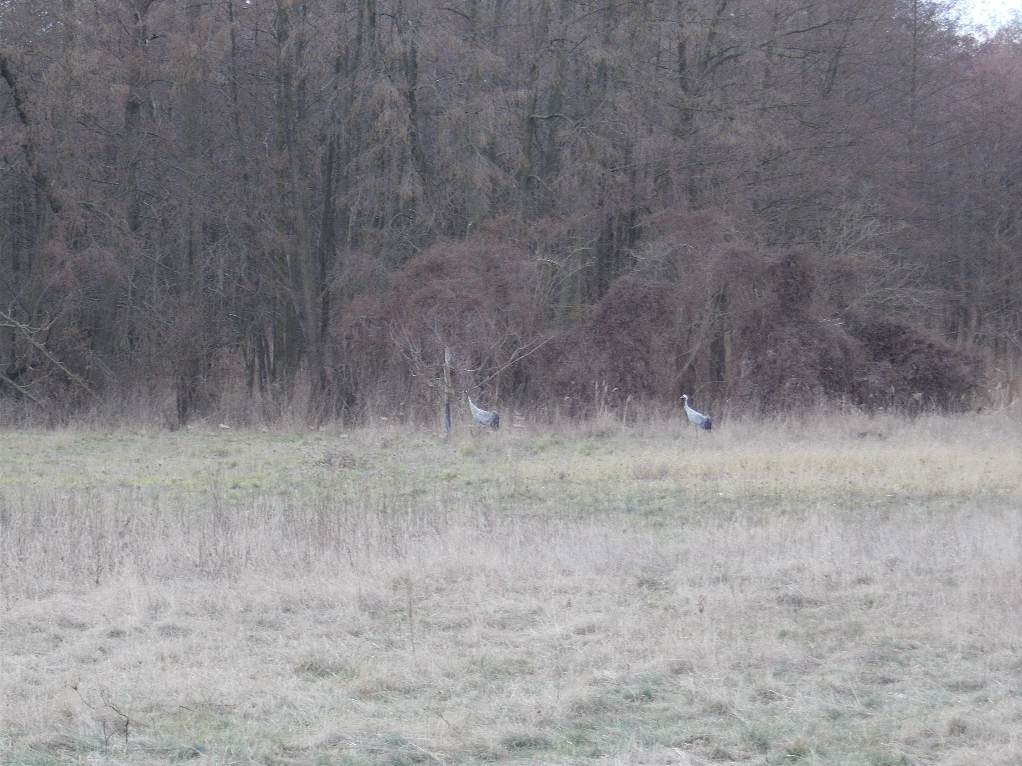
Two cranes standing in a grassy field in front of a dense, bare-branched forest.
Two cranes foraging at the edge of the alder swamp within the Krielower See nature reserve.

Krielower See Nature Reserve history and protected-area timeline

The Krielower See itself is a relic of glacial landscape formation during the Pleistocene, when ice tongues and meltwater carved out the shallow basin in which it lies. In historical times the open water was known as the Krielower See, while the increasingly marshy surroundings were referred to as the Krielower Luch. Over the centuries, the lake gradually filled in, and peat cutting in places further altered its character, until it became the almost fully overgrown wetland seen today.

Formal conservation came much later. The Brandenburg Minister for Agriculture, Environmental Protection and Spatial Planning designated the area as the Naturschutzgebiet Krielower See on 31 August 2004, under Section 21 in conjunction with Section 19 of the Brandenburg Nature Conservation Act. The designation also aligned the area with European nature protection frameworks, and the site is now listed as a Fauna-Flora-Habitat (FFH) site under the designation DE 3543-301, part of the Natura 2000 network. Subsequent restoration work focused on the surrounding Krielower meadows aimed to re-flood formerly drained grasslands and to support traditional grazing practices, including the use of water buffalo for landscape management in areas made too wet for machinery.

Krielower See Nature Reserve landscape and geographic character

The landscape of the reserve is defined by a flat, low-lying glacial terrain typical of central Brandenburg. Its central landform is the former lake basin of the Krielower See, now an almost completely silted-up waterbody within a wider moor channel. The historic open water has been replaced by a mosaic of reed beds, sedge marshes, wet meadows, willow scrub, and alder carr, framed by the older Pleistocene sand formations of the Phöbener Berge to the east, where the Wachtelberg rises to about 83.7 meters and the Haakberg to about 87.9 meters above sea level.

Once these ice age deposits formed the western edge of a large sand island between the Havel and the Plessow lakes. North and south of the Krielower See, the Torfgraben, a seasonally water-bearing former peat cutting, provides a narrow linear connection toward the Großer Plessower See and the Havel. The combination of glacial lake basin, peat cuttings, glacial sand uplands, and floodplain zones gives the reserve a layered, ecologically diverse topography despite its modest elevation differences. Today the area reads visually as a wide, open wetland landscape interrupted by patches of wet woodland and bordered by farmland and the Berlin to Magdeburg railway corridor to the south.

Krielower See Nature Reserve ecosystems, habitats, and plant life

Ecologically, the reserve centers on a dynamic gradient from open water to fully terrestrial wetland. The remnant eutrophic lake carries water vegetation characteristic of the Magnopotamion and Hydrocharition vegetation types, including pondweed communities and floating aquatic plant associations. Surrounding peat cuttings support specialized stonewort (Armleuchteralgen) communities, while the larger wetland matrix is composed of reed communities, large sedge marshes (Großseggenriede), floodplain grasslands (Flutrasen), Molinia meadows on calcareous substrates, and wet tall-herb communities.

Willow scrub and alder carr (Erlenbruch) occupy the wetter transitions, particularly along former drainage channels and the edges of the old lake basin. These habitats correspond to officially listed natural habitat types of community interest under Germany's federal nature conservation act. The management goal is to preserve, restore, and develop the area as a key segment of the regional biotope network between the Kleiner Plessower See and the Havel, allowing water, nutrients, and species to move between these larger wetland systems.

Krielower See Nature Reserve wildlife and species highlights

Krielower See is recognized as a habitat and retreat area, as well as a potential source for renewed expansion, for a wide range of protected and ecologically important species. Common cranes (Grus grus) are especially visible along the edge of the alder carr, as captured in the area's iconic imagery. The reserve also supports a rich community of marshland and wetland birds including spotted crake (Porzana porzana), corncrake (Crex crex), common snipe (Gallinago gallinago), and garganey (Anas querquedula).

Among herptiles, the reserve hosts the natterjack toad-adjacent species complex including the garlic toad (Pelobates fuscus) and moor frog (Rana arvalis), along with the grass snake (Natrix natrix). Mammals include the Eurasian otter (Lutra lutra), while the European beaver (Castor fiber) plays an especially significant ecological role by damming drainage channels and rewetting former dry grasslands. The invertebrate fauna is notable for rare snails such as the small discoid snail Anisus vorticulus and the two Vertigo species, Vertigo moulinsiana and Vertigo angustior, which are listed as species of community interest. In addition, water buffalo introduced to the area help maintain open wet grassland habitats that can no longer be managed mechanically.

Krielower See Nature Reserve conservation status and protection priorities

The reserve is designated under Brandenburg state law and integrated into the European Natura 2000 network as a Fauna-Flora-Habitat site. Its primary conservation objective is to preserve and develop the area as a functioning segment of the regional biotope network linking the Havel floodplain and the Plessow lake chain. This includes maintaining and restoring open water, peat-cutting ponds, reed beds, wet meadows, tall-herb vegetation, willow scrub, and alder marsh.

A second objective involves protecting habitats for species of community interest, particularly common crane, spotted crake, corncrake, common snipe, garganey, grass snake, garlic toad, moor frog, otter, and rare mollusk species. Long-term faunistic and floristic monitoring is carried out by NABU conservation area caretakers, with records reported to the Naturgucker observation portal, supporting evidence-based management. Restoration of the Krielower meadows, sparked in part by the arrival of beavers that have raised water tables and made mechanical management impossible, has shifted management toward grazing-based conservation using hardy livestock such as water buffalo.

Krielower See Nature Reserve cultural meaning and human context

The Krielower See lies within a long-settled rural landscape of Brandenburg, interspersed among the historic villages of Krielow, Schmergow, Kemnitz, and Phöben. These villages, like much of the surrounding Havelland, have traditionally depended on agriculture, particularly on the extensive pastures and meadows of the Havel floodplain. The transformation of the lake basin from open water to wetland and the loss of usable dry pastureland reflects broader regional patterns of land-use change in Brandenburg after the second half of the twentieth century.

Elements of cultural identity remain visible in the area's topography, the legacy of peat cutting that shaped parts of the wetland, and in the continued practice of traditional livestock grazing. The introduction of water buffalo to maintain wet meadows adds a distinctive contemporary farming element tied directly to the reserve's conservation strategy.

Top sights and standout views in Krielower See Nature Reserve

Krielower See stands out for its combination of a former glacial lake now functioning as a near-natural wetland, a key ecological link between the Plessow lakes and the Havel, and a remarkable diversity of protected species within a relatively compact 155-hectare area. The visible presence of cranes along the alder carr edge, the visible and ecological impact of beaver activity, and the use of water buffalo as conservation grazers give the reserve a distinctive identity that combines glacial landscape history with active, habitat-driven conservation.

Best time to visit Krielower See Nature Reserve

Visit timing at Krielower See is shaped primarily by seasonal wetland dynamics and wildlife activity rather than by structured visitor programming. Spring is often the most rewarding season, when rising water levels, fresh growth in the reed beds and wet meadows, and the arrival and display of cranes and other marshland birds are most visible. Early morning and dusk tend to offer the best chances of observing wetland birdlife and large mammals such as the otter or beaver.

Summer brings lush growth across reed beds, sedge marshes, and wet tall-herb communities, when insect activity peaks and frog and toad populations are most audible. Autumn can deliver rich color and movement across the landscape as migratory birds pass through and cranes prepare for departure. Winter tends to be quieter and colder, with frozen or partially frozen wetland surfaces and minimal bird song.

Monthly climate preview

Long-term temperature ranges and precipitation averages across representative coordinates

Naturschutzgebiet Krielower See Climate Normals and Monthly Weather Patterns

Representative coordinate records reveal a measured annual rhythm of monthly temperature variation and precipitation totals at Naturschutzgebiet Krielower See. Reviewing the complete twelve-month climatology profile provides deeper analytical insight into multi-year meteorological standards.
Annual mean9 °C
-1 °C20 °C
Jan-1°
Feb
Mar
Apr
May14°
Jun18°
Jul20°
Aug20°
Sep15°
Oct
Nov
Dec
Warmest month
July

20.3 °C

Coolest month
January

-0.7 °C

Wettest month
July

2.4 mm/day

Driest month
April

1 mm/day

Park location guide

Geography guide, regional context, and park location map for Krielower See Nature Reserve

Krielower See Nature Reserve park geography, regions, and map view in Germany

Understand where Krielower See Nature Reserve sits in Germany through a broader geographic reading of the surrounding landscape, nearby location context, and its mapped position within the national park landscape.

How Krielower See Nature Reserve fits into Germany

Germany is a federal republic in Western and Central Europe with a population of over 83 million across sixteen constituent states. It is Europe's largest economy by nominal GDP and a major global exporter and importer. The capital is Berlin, and the country borders Denmark, Poland, Czech Republic, Austria, Switzerland, France, Luxembourg, Belgium, and the Netherlands.

Wider geography shaping Krielower See Nature Reserve in Germany

Germany is located in Western and Central Europe, spanning 357,022 km². It borders Denmark to the north, Poland and the Czech Republic to the east, Austria and Switzerland to the south, and France, Luxembourg, Belgium, and the Netherlands to the west. The country has coastlines on the Baltic Sea and North Sea to the north, with the Alps located in the southern region.

Map view of Krielower See Nature Reserve

Use this park location map to pinpoint Krielower See Nature Reserve in Germany, understand its exact geographic position, and read its mapped placement within the surrounding landscape more clearly.

Pigeon | © OpenStreetMap contributors

Location context for Krielower See Nature Reserve

Brandenburg

Visual reference collection for the glacial lake basin, reed beds, and wetland habitats of Brandenburg.

Naturschutzgebiet Krielower See Photos and Protected Landscape Scenery

Visual records reveal the flat glacial terrain, extensive reed beds, and alder carr defining the protected wetland reserve. Examining these landscape photographs helps clarify the ecological character of the former lake basin and surrounding Brandenburg habitats.

Two cranes standing in a grassy field in front of a dense, bare-branched forest.

Park atlas

Compare regional wetland reserves and connected lowland habitats across Brandenburg

Explore Parks Near Naturschutzgebiet Krielower See and Surrounding Protected Landscapes

Browsing other parks near Naturschutzgebiet Krielower See reveals broader ecological patterns within the surrounding Havelland region. Continuing from this glacial lake reserve allows for deeper comparison of lowland wetland ecosystems and connected floodplain corridors.
Watercolor painting of a lush, flat landscape with low green hills in the distance and wetland vegetation in the foreground.
Protected landscapeBrandenburg
About 7.4 km away#1 closest

West

Landschaftsschutzgebiet Brandenburger Osthavelniederung: Protected Landscape and Regional Geography

Mapped Havel River floodplain and glacial moraine terrain in Brandenburg.

Covering over 9,000 hectares, this protected landscape serves as a prime example of the Brandenburg Havel region. The area integrates a network of canals, dikes, and backwater lakes with isolated moraine ridges, creating a diverse geographic mosaic of river-managed lowlands and forested glacial remnants.

Area
93.81 km²
Established
1998
Relief
Lowland
Climate
Temperate
A soft watercolor illustration showing rolling green hills, a small stream winding through the foreground, and distant purple-toned peaks against a white background.
Nature reserveBrandenburg
About 7.6 km away#2 closest

Southeast

Glindower Alpen: Protected Nature Reserve and Clay Mining Geography in Brandenburg

A striking post-industrial landscape and nature reserve

Glindower Alpen is a 120-hectare nature reserve near Werder, Germany, characterized by an atypical terrain of deep ravines and ridges resulting from historical clay mining. This protected area stands out as an island of mixed deciduous forests and dry grasslands amidst the broader flat geography of the Brandenburg region.

Area
1.19 km²
Established
1995
Relief
Upland
Climate
Temperate
A watercolor illustration showing a landscape with small clusters of trees and grassy ground under a soft, light-filled sky.
Nature reserveBrandenburg
About 10 km away#3 closest

Southwest

Lehniner Mittelheide und Quellgebiet der Emster: Nature Reserve and Protected Landscape Atlas

Mapping Brandenburg inland heath and spring valley terrain

Examine the geographic layout of Lehniner Mittelheide und Quellgebiet der Emster, a nature reserve in the Brandenburg district of Potsdam-Mittelmark. This protected area connects dry sandy heathland with the aquatic corridors of the Emster headwaters and Mühlenteich pond, offering a clear example of glacial lowland landscape integration.

Area
6.4 km²
Established
1996
IUCN
IV
Relief
Lowland
A soft, artistic watercolor painting of a river landscape with trees, grassy banks, and rolling hills in the background.
Nature reserveBrandenburg
About 11 km away#4 closest

Northeast

Falkenrehder Wublitz Nature Reserve: Brandenburg Wetland Geography and Protected Landscape Atlas

A mapped riparian wetland reserve within the Havel valley floodplain.

Falkenrehder Wublitz is a nature reserve in Brandenburg, Germany, established to safeguard a representative slice of the Havel lowland wetlands. Centered on the Wublitz side arm of the Havel river, this protected area features diverse aquatic habitats, wet meadows, and swamp forests. The reserve plays a functional role in regional conservation by linking smaller wetland pockets into a broader, connected riparian landscape near the Havel Canal.

Area
0.976 km²
Established
2002
IUCN
IV
A soft watercolor illustration of a rolling green landscape with a small cluster of trees and birch trees in the foreground, against a pale background.
Nature reserveBrandenburg
About 13 km away#5 closest

Northeast

Ferbitzer Bruch Nature Reserve: Exploring Brandenburg Protected Landscape Boundaries

A lowland mosaic of sandy habitat in the Havelland region

Ferbitzer Bruch provides a focused look at the sandy lowland ecosystems characteristic of western Brandenburg. This nature reserve, anchored between the Havel Canal and the Döberitzer Heide, preserves a distinct mosaic of open heath, scrub, and woodland habitats that define this segment of the German landscape.

Area
11.564 km²
Established
1996
IUCN
IV
A soft watercolor painting showing rolling green hills, patches of open land, and trees against a pale sky background.
Nature reserveHavelland
About 13 km away#6 closest

Northeast

Döberitzer Heide Nature Reserve: Geographic Atlas and Protected Landscape Mapping

Glacial sand flats and heathlands in the Havelland region

Döberitzer Heide occupies a unique position on the southeastern Nauener Platte, providing a study of dry heath, grassland, and wetland habitats. Once a restricted military training ground, the area now functions as a vital protected landscape where European bison and wild horses maintain open terrains. This atlas entry focuses on the regional geography and the structural components of this nature reserve situated near the urban centers of Berlin and Potsdam.

Area
34.15 km²
Established
1997
Relief
Upland
Climate
Temperate
A horizontal watercolor illustration depicting a calm lake surrounded by soft green forest and distant hazy hills.
Protected areaBerlin
About 19 km away#7 closest

East

EU-Vogelschutzgebiet Westlicher Düppeler Forst: Protected Area and Regional Geography

Ecological sanctuary and Havel lakeshore landscape in Berlin

Located in the Steglitz-Zehlendorf district, this protected area spans nearly 10 square kilometres of diverse woodland and aquatic terrain. The site combines historical cultural landmarks with essential breeding grounds for migratory birds, including significant woodpecker populations and varied riparian corridors throughout the southwestern Berlin borderlands.

Area
9.44 km²
Established
2003
Watercolor painting of a green wetland area with soft, blurred rolling hills in the background.
Nature reserveBerlin
About 20 km away#8 closest

East

Großes Fenn Nature Reserve: Protected Peatland and Kettle Bog Geography in Berlin

A study of post-glacial landforms and mire environments.

Großes Fenn represents a rare urban kettle bog formed during the last glacial period, now protected within the Berlin region. This reserve showcases the historical peat-forming processes and the fragile ecological balance of small depressions in the Düppeler Forest, offering a compact site for understanding glacial landscape legacies.

Area
0.064 km²
Established
1986
IUCN
IV

Common questions about visiting, size, designation, and location context for Krielower See Nature Reserve

Krielower See Nature Reserve FAQs for park facts, access, geography, and protected area context

Find quick answers about Krielower See Nature Reserve, including protected-area facts, park geography, trail and visitor context, and how the park fits into its surrounding country and regional landscape.
MoriAtlas Explorer

Continue Your Protected Areas Search Across the Global Atlas

Deepen your exploration by continuing the structured search for national parks and protected areas worldwide. Utilize the comprehensive filtering capabilities to compare different conservation landscapes and refine your understanding of global park geography. Discover more about the distribution and characteristics of protected natural areas.

Global natural geography