Why Langue de Barbarie National Park stands out
Langue de Barbarie National Park is best known for its exceptional bird populations and its role as a nesting site for threatened marine turtles. The shallow lagoon waters and mudflats provide critical feeding and resting grounds for thousands of migratory birds traveling along the East Atlantic Flyway. The park's beaches serve as important nesting habitat for hawksbill turtles, one of the most endangered marine turtle species globally. The peninsula's dramatic transformation following the 2003 breach also makes it a notable example of coastal erosion dynamics in West Africa.
Langue de Barbarie National Park history and protected-area timeline
The modern history of Langue de Barbarie is marked by a dramatic environmental transformation that reshaped the peninsula's geography. In October 2003, authorities cut a four-meter-wide breach in the peninsula near Saint-Louis as an emergency measure to mitigate potential flooding in the city. However, the artificial opening quickly widened beyond all expectations, expanding to 800 meters within weeks and effectively severing the southern end of the peninsula from the mainland. This breaching event transformed what had been a peninsula into an island, fundamentally altering the local hydrology and ecology. By December 2013, the sea had claimed more than three kilometers of land, resulting in the loss of villages and tourist facilities. By January 2020, the breach had widened to approximately six kilometers. This ongoing coastal erosion phenomenon has caused significant changes to the flora and fauna of the area, while simultaneously creating new ecological conditions that continue to evolve.
Langue de Barbarie National Park landscape and geographic character
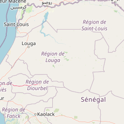
The landscape of Langue de Barbarie National Park is defined by its coastal peninsula setting, characterized by low-lying sandy terrain that rises only slightly above sea level. The peninsula consists of mobile sand dunes that shift with wind and tidal forces, creating a dynamic and somewhat fragile environment. Beach areas line the ocean-facing side, while the landward side borders the calmer waters of the Senegal River estuary and associated lagoon systems. The park encompasses tidal mudflats that are exposed at low tide and submerged during higher water levels, supporting specialized salt-tolerant vegetation and benthic organisms. The overall topography is flat and uniform, with the most significant relief provided by the dune ridges that parallel the coastline. The park's island portion, formed after the 2003 breach, now consists of the isolated southern section separated from the mainland by the widened channel.
Langue de Barbarie National Park ecosystems, habitats, and plant life
The ecological character of Langue de Barbarie National Park centers on its function as a coastal wetland ecosystem where riverine and marine influences intersect. The shallow, sheltered lagoon waters create ideal conditions for fish and crustaceans that form the base of the food web supporting abundant bird populations. The park supports overwintering populations of greater flamingos, various species of herons and egrets, and numerous wader species including sandpipers, plovers, and curlews. Terns and gulls nest on the beach areas, while the adjacent waters provide foraging habitat for seabirds. The marine environment supports a diverse fish community that sustains both avian predators and marine mammals. The tidal flats support communities of mollusks and crustaceans that process organic material and serve as prey for shorebirds. The vegetation consists primarily of salt-tolerant plant species adapted to the brackish conditions and periodic inundation.
Langue de Barbarie National Park wildlife and species highlights
The wildlife of Langue de Barbarie National Park is characterized by exceptional concentrations of waterbirds and the presence of threatened marine reptiles. The park supports abundant populations of flamingos, which feed on brine shrimp and algae in the shallow lagoon waters. Herons, egrets, and bitterns stalk the wetlands in search of fish and invertebrates, while flocks of waders probe the mudflats for crustaceans and mollusks. The park is particularly notable for its turtle populations, with three species found within its waters and beaches. The critically endangered hawksbill sea turtle uses the park's beaches for nesting, making it a site of particular conservation importance for this globally threatened species. The surrounding ocean waters support dolphins and occasionally larger marine species that pass through the coastal zone. The fish community in the estuary provides prey for both avian and marine predators, creating a productive and ecologically interconnected system.
Langue de Barbarie National Park conservation status and protection priorities
Langue de Barbarie National Park represents an important conservation priority in West Africa due to its role as a Ramsar-designated wetland and habitat for globally threatened species. The park's designation as a Ramsar site in April 2021 acknowledged its international significance as a wetland that supports biodiversity and provides ecosystem services. The protection of hawksbill turtle nesting beaches is particularly critical, as this species has suffered severe population declines throughout its range due to egg collection, coastal development, and fisheries bycatch. The park also serves as a key node in the network of West African coastal protected areas that support migratory birds traveling the East Atlantic Flyway. Conservation challenges include the ongoing coastal erosion triggered by the 2003 breach, which continues to alter the park's habitat structure and may require adaptive management strategies. The proximity to Saint-Louis also creates human-use pressures that require active management to balance conservation with sustainable use.
Langue de Barbarie National Park cultural meaning and human context
Langue de Barbarie sits in the vicinity of Saint-Louis, one of Senegal's oldest cities and a historic center of West African trade and colonial activity. The peninsula has traditionally supported fishing communities whose livelihoods depend on the rich marine and estuarine waters. The area holds cultural significance as part of the broader Senegal River region, which has been inhabited for centuries and features in the historical narratives of trade, migration, and cultural exchange along the West African coast. The landscape's transformation following the 2003 breach has also created new considerations for local communities who once accessed the area by land but now must use boats to reach the island portion. The park's establishment as a protected area reflects a modern approach to balancing community resource use with biodiversity conservation.
Top sights and standout views in Langue de Barbarie National Park
Langue de Barbarie National Park offers a distinctive combination of coastal wilderness, significant birdlife, and marine turtle nesting habitat within a relatively compact protected area. The park provides accessible wildlife observation opportunities in a scenic coastal setting where the desert meets the Atlantic. The Ramsar designation reflects the wetlands' importance to migratory waterbirds, while the presence of nesting hawksbill turtles adds a rare and endangered element to the park's biodiversity. The ongoing coastal transformation creates a dynamic landscape that illustrates natural processes and the challenges of coastal zone management in a changing climate. Visitors can experience a region where geography, ecology, and human history intertwine along one of West Africa's most interesting coastal interfaces.
Best time to visit Langue de Barbarie National Park
The optimal time to visit Langue de Barbarie National Park coincides with the dry season from November through May, when conditions are most favorable for wildlife observation and outdoor exploration. During this period, migratory birds from Europe are present in large numbers, particularly between November and March when flamingos and various wader species concentrate in the wetland areas. The dry season also offers more comfortable temperatures and lower humidity compared to the rainy summer months. The period from March to May often sees hawksbill turtles nesting on the beaches, providing opportunities to observe these endangered reptiles. The wet season from June to October brings higher temperatures and increased rainfall, which can limit accessibility and make wildlife viewing more challenging, though the landscape remains accessible.